

Abstract
The development, floruit and decline of the urban phase of the Indus Civilisation (c.2600/2500-1900 BC) provide an ideal opportunity to investigate social resilience and transformation in relation to a variable climate. The Indus Civilisation extended over most of the Indus River Basin, which includes a mix of diverse environments conditioned, among other factors, by partially overlapping patterns of winter and summer precipitation. These patterns likely changed towards the end of the urban phase (4.2 ka BP event), increasing aridity. The impact of this change appears to have varied at different cities and between urban and rural contexts. We present a simulation approach using agent-based modelling to address the potential diversity of agricultural strategies adopted by Indus settlements in different socio-ecological scenarios in Haryana, NW India. This is an ongoing initiative that consists of creating a modular model, Indus Village, that assesses the implications of trends in cropping strategies for the sustainability of settlements and the resilience of such strategies under different regimes of precipitation. The model aims to simulate rural settlements structured into farming households, with sub-models representing weather and land systems, food economy, demography, and land use. This model building is being carried out as part of the multi-disciplinary TwoRains project. It brings together research on material culture, settlement distribution, food production and consumption, vegetation and paleoenvironmental conditions.
Export citation and abstract BibTeX RIS

Original content from this work may be used under the terms of the Creative Commons Attribution 4.0 license. Any further distribution of this work must maintain attribution to the author(s) and the title of the work, journal citation and DOI.
1. Introduction
The urban phase of the Indus Civilisation (c.2600/2500-1900 BC) offers an interesting case of social resilience and transformation in the face of a variable and changing climate. This early expression of urbanism in South Asia has long been associated with climate dynamics, believed to have been enabled by an intensification in precipitation and, centuries after, impacted by a trend towards aridification. However, the interrupted trajectories of Indus cities contrast with the trajectories of smaller settlements (e.g. villages), which survive the period and, in some regions, increase in number (Green and Petrie 2018). This pattern suggests a systematic difference between urban and rural in terms of sustainability and resilience of practices and institutions under environmental stress (Petrie 2019, Petrie et al 2019). Although there is enough evidence to support a link between climate and social change, the mechanism(s) by which aridification contributed to de-urbanisation, but not depopulation, is still under debate. Moreover, the continuity of occupation of the rural landscapes poses a challenge, particularly to those interpretations defining the abandonment of the Indus cities as societal collapse rather than social transformation (Petrie 2019).
Here we introduce an agent-based modelling (ABM) approach to represent and connect the factors possibly determining the trajectory of village settlements of the Indus Civilisation. This approach includes a collection of modular components designed to be sufficiently explicit, but still generic, representations of weather and land systems, food economy, demography and settlement at a local-to-regional scale. Although independent, all modules are being designed to fit together into a single simulation model, the Indus Village model. Working towards a better understanding of how environmental factors influence social change, we seek to use this integral model to assess the implications of different food production strategies for the sustainability of urban and rural populations and the resilience of such strategies in the face of climate-driven changes in water availability.
This work is part of TwoRains (2015–2020, ERC H2020-648609), a multi-disciplinary project focused on Indus Civilisation sites in Haryana, NW India. The project goal is to improve the understanding of human adaptations to variable rainfall systems and climate change, as well as the resilience and sustainability of the choices available during the development of the Indus Civilisation.
2. Indus Civilisation: a case of collapse or resilience?
The Indus Civilisation spread over a large portion of South Asia, including most of modern Pakistan and parts of northwest India. The Indus Civilisation is characterised almost exclusively through archaeological evidence, specifically, by a set of unique architectural and artefactual types (e.g. Wright 2010, pp 23, 326–30). More notably, the urban phase of the Indus Civilisation, also named the Harappa or Mature Harappan period (c.2600/2500-1900 BC), presents one of the earliest instances of urban settlements worldwide (Mcc 1981, Possehl 1990, 2002, Petrie 2013). The full expression of Indus urbanisation appears limited to five settlements that each grew to a significant size (80+ ha) between c.2600 and 2500 BC and thrived for an exceptional amount of time (c. 600–700 years; Petrie 2013). Indus cities were far apart from each other, and were located in different ecological zones within the plains of the Indus River Basin (figure 1). As their low number indicates, cities were the exceptions to the Indus settlement system, which was mainly comprised of towns and villages. Several lines of evidence suggest that Indus Civilisation was a predominantly rural society (Singh et al 2018, 2020, Parikh and Petrie 2019).
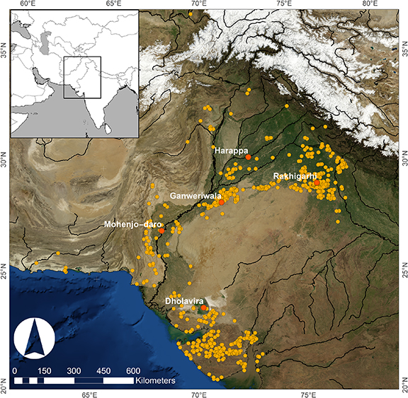
Figure 1. The distribution of Mature Harappan major (white) and minor (yellow) sites.
Download figure:
Standard image High-resolution imageIndus social and cultural complexity underwent a period of deterioration (c.2000–1900 BC), culminating with the abandonment of all but one of the large urban centres (Harappa), which itself saw a decline in occupied area, and a cessation in the use of Indus script, seals, and many elements specific to the Mature Harappan material culture. South Asia would not see a comparable expression of urbanism for many centuries, which makes it distinct to the trajectory observed in the Near East (Petrie 2013).
Many causes have been proposed for the de-urbanisation of the Indus Civilisation, among which climate change has received increasing attention (Macdonald 2011, Dutt et al 2019). Although a consensus is still elusive (Petrie 2017), recent studies offer multi-proxy evidence that suggest both the emergence and decline of the Mature Harappan phase broadly coincides with climatic changes linked to the amelioration and degradation of regional precipitation levels (Dixit et al 2018, Giesche et al 2019).
The Indus Civilisation thus presents a compelling case of contrasting trajectories of different components of a socio-ecological system, where the decline of urban lifeways coexists with the resilience of rural contexts (Petrie 2019). The relatively robust urban centres, whose occupation endured centuries, were ultimately unsustainable when facing a prolonged period of environmental stress. Villages, however, occupied a central place in the Indus settlement system before, during, and after the urban period, suggesting that rural lifeways remained flexible and capable of adaptative transformation (Madella and Fuller 2006: figure 9, Parikh and Petrie 2019). If Indus urbanism was an experiment that proved unsustainable, Indus villages may hold the key for a successful model (or rather models) of agricultural systems that can be resilient to climate change.
3. Indus food production: patterns of diversity and variability
Archaeological evidence dating to the Mature Harappan period extends over most of the Indus River Basin and marginally towards Iran and northern Afghanistan (figure 1). This large area consists of a mix of diverse environments, affected by desert (BWh), semi-arid (BSh) and humid subtropical (Cwa) climates under the Köppen–Geiger classification (Beck et al 2018). Diversity and variability of environmental conditions are expressed on both local and regional scales, including alluvial plains and fans, intermontane valleys and islands, with water input relying on perennial rivers, rainfall, and groundwater.
The environmental diversity and variability in the Indus River Basin are largely due to the incidence of partially overlapping winter and summer rainfall systems (figure 2; Petrie et al 2017). Winter precipitation is produced by the confrontation of westerly weather patterns, carrying moisture from the Persian Gulf and the north of the Arabian Sea, with the southern slopes of the Hindu Kush, the Karakoram, and the Himalayas. Summer precipitation is associated with the South Asian summer monsoon, which is triggered by the northward movement of the Intertropical Convergence Zone. The presence of these two atmospheric systems is influenced by complex climate dynamics, and renders precipitation in this area highly variable from one year to another (Baudouin et al 2020a, 2020b).
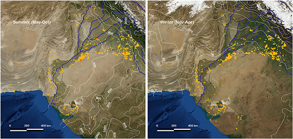
Figure 2. The distribution of Mature Harappan major (orange) and minor (yellow) urban sites, and the average total precipitation (mm) during summer (May–October) and winter (November–April) over the Indus Basin during 1951–2000 (Global Precipitation Climatology Centre, version 2018 at 0.25°; Meyer-Christoffer et al 2018).
Download figure:
Standard image High-resolution imageDespite the high interannual and spatial variability, the separation of winter and summer rains remains consistent throughout the region (figure 3, top row). Both rainy seasons are well defined with daily precipitation often peaking in February and July, separated by dry gaps around May and November (Baudouin et al 2020a, 2020b). Even though the summer monsoon is stronger, particularly on the plains, both rainfall systems are key to alleviate soil water stress as reflected in the Agricultural Reference Index for Drought (ARID) index (Woli et al 2012), which accounts for other factors affecting soil water balance (figure 3, bottom row).
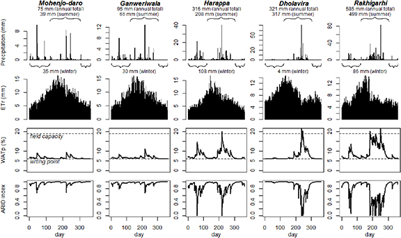
Figure 3. Daily precipitation during 1990 (NASA POWER) on the location of the five major Indus urban centres and estimated values of reference evapotranspiration (ETr), proportion of soil water content (WATp), and the ARID index (Woli et al 2012). ETr was calculated following Allen et al 1998 and WATp and ARID were simulated using the Soil Water Balance model (Wallach et al 2014, pp 24–28 and 138–144).
Download figure:
Standard image High-resolution imageArchaeological evidence suggests that Indus populations were already well adapted to those environments during the pre-urban or Early Harappan Period (c.3000–2600 BC) (Petrie et al 2017, Petrie 2019). The homogeneity implied by the term 'civilisation' should consider the many differences between Indus sites regarding not only artefactual and architectural styles, but also subsistence strategies (Petrie et al 2017, 2018). The spectrum of agropastoral strategies of the Indus population is still not fully understood. However, there is clear evidence that Indus farmers engaged with a wide range of food production practices (Joglekar et al 2013, Petrie and Bates 2017). The Indus subsistence economy involved mainly the cultivation of wheat, barley, millets and other staple food crops, raising cattle (zebu, water buffalo), sheep and goat, and other activities depending on local conditions, such as fishing and foraging.
Recent analyses of paleoclimate proxies (e.g. Dixit et al 2018, Giesche et al 2019) have indicated that Indus urbanism broadly coincides with a distinct intensification of precipitation in the region (4.5–4.3 ka BP), which appears to reflect an increase in winter precipitation (Giesche et al 2019), while the decline and abandonment of cities occurred during a period of aridification that was driven by the decrease in both winter and summer precipitation. Among the many subsistence activities performed in the Indus Civilisation, crop-based agriculture is the most vulnerable to the risks entailed by the complex conditions influencing water availability in this region. It is important to consider the degree to which the decline of the Indus cities might have been directly or indirectly linked to the underperformance or failure of agricultural food production.
Recent contributions have raised a number of points specifically concerning the diversity of crops grown and consumed, both at local and regional scales, during the time span of the Indus Civilisation (e.g. Madella and Fuller 2006, Petrie et al 2016, Petrie and Bates 2017, Bates et al 2017a, 2017b, Bates 2019). Given the current archaeobotanical evidence, it has been argued that the frequency in use of winter crops (rabi—wheat, barley, pea, lentil, chickpea) and summer crops (kharif—millet, rice, tropical pulses) responded to the distribution of the two rainfall systems (Kajale 1991, Meadow 1996, Weber 1999, Fuller and Madella 2002, Madella and Fuller 2006, Weber et al 2010, Wright 2010, Fuller 2011, Pokharia et al 2014, Weber and Kashyap 2016). The higher abundance of summer crops in southern Indus sites (Gujarat), and lower abundance in western sites (Sindh), correlates well with the distribution of summer precipitation (figure 2, left). Conversely, winter crops are clearly less present in those sites that receive the least amount of winter rain (figure 2, right). The eastern sites (Haryana and Indian Punjab), receiving both summer and winter precipitation, display significant evidence of crops grown in both seasons.
If conditions today are a valid reference for the past, the population inhabiting sites in the Lower and Middle Indus would have endured extremely arid conditions year-round (figure 3, Mohenjo-daro and Ganweriwala). The location of Mohenjo-daro receives an average of 79 mm of annual precipitation (1984–2008, NASA POWER), indicating that this important city could have relied almost completely on river or groundwater. Conversely, rainfed agriculture would have been feasible in the northern regions closer to the Himalayas, which probably had the best conditions for growing both winter and summer crops with no or little need for irrigation. The easternmost part of the latter region, Haryana and Indian Punjab, receives the most precipitation on average (499 mm at Rakhigarhi), though this is mainly due to the summer monsoon (figure 3, Rakhigarhi).
Archaeobotanical research on the eastern sites suggests that wheat and barley (Triticum sp., Hordeum vulgare) could have played a more significant role based on their calorific value, even under conditions where summer crops are less exposed to risks associated with aridity (Bates et al 2017a). However, the widespread presence of millets (such as Echinochloa sp.) indicates that these crops also received special attention from Indus farmers. The ubiquity of small grain crops raises the more general issue of how to assess the factors determining the factual and perceived adequacies of different crops, which could potentially include aspects such as resistance to drought, easiness of cultivation, familiarity, functionality or even taste.
Haryana and Indian Punjab are particularly interesting regions not only to illuminate food production in the Indus Civilisation, but also to investigate the decision-making involved in crop choices of farmers in other past and also present societies. Crop choices are more complex in regions like Haryana where conditions can sustain two growing seasons per year. It has been argued that different forms of multi-cropping were used by Indus Civilisation farmers (Petrie and Bates 2017). Multi-cropping, i.e. 'the production of two or more crops per year on the same land', is deemed an effective risk-management strategy in the past, buffering the effects of insufficient harvests of any single crop in any particular year (Marston 2011). As defined by Andrews and Kassam (1976, Table 1), the term refers not only to growing crops on the same space of land over multiple seasons (sequential multi-cropping), but also combining crops within the same season (intercropping), e.g. combining crops with similar ecological requirements or growing habits on the same area of land. More broadly, the diversification of subsistence practices has been argued to be the most common adaptation to a 'predictable unpredictability' (Miller 2011).
4. Towards a 'testable narrative' of the Indus Civilisation
One of the overarching objectives of the TwoRains project is the synthesis, integration and interrogation of the heterogeneous datasets generated by its members through the realisation of a modelling programme. The programme mission is to explore human adaptation to the shifting landscapes of NW India and expose the sustainability of different types of possible human responses to abrupt climate change.
More specifically, the modelling approach presented here aims to evaluate the following sequence of hypotheses or 'testable narrative', which is informed in the background knowledge summarised above:
- 1.Urbanism is the product of a complex system. Given enough frequency of exchange between settlements, resources tend to concentrate on 'hubs'. This theoretical premise agrees with the archaeological evidence, as part of the characteristic Indus artefact assemblage was either imported or made of imported raw materials from significant distant sources (Wright 2010, pp 148–66, 182–203). There is also evidence dating to the third millennium B.C. for the integration of Indus settlements into a larger exchange network (Uesugi 2019), with the presence of Indus products in Central Asia, Pakistani Makran, Persian Gulf, and Mesopotamia (Possehl 2002, Wright 2010, pp 225–32).
- 2.Local diversity hinders settlement rural-urban differentiation. Diversity of cropping strategies at a local scale, together with population dispersal in small communities, are cultural adaptations to the unpredictability of Indus environments. These traits improve resilience locally, but decrease productivity at a regional scale, shortening surplus directed to non-food-producing activities and exchange, thus undermining urbanism.
- 3.Favourable conditions relax adaptation. Pre-urban Indus settlements were already well adapted to unpredictability. However, motivated by the more favourable conditions towards the transition to the urban period, farmers progressively took more risks by specialising in the most productive crops under these conditions, being able to feed more people, thus supporting settlement growth and urbanism. Productivity here refers to the harvest yield in bulk weight per labour hour and area, with the assumption that under their respective optimal conditions, these crops are more productive than the alternatives.
- 4.Unfavourable conditions strengthen adaptation. Once precipitation began to decrease towards the end of the urban period, the productivity of winter mono-crop strategies also decreased and, with them, the generation of surplus for exchange. With fewer opportunities for exchange, farmers had strong motivation to adopt alternative cropping strategies (diverse, resilient, low-level productivity).
- 5.The exchange network collapses. With increasing aridity and higher local crop diversity, regional food production rates become progressively smaller and the extensive, unified exchange network eventually collapses.
- 6.The subsistence crisis led to migration and abandonment of cities. With exchange networks collapsing, urban settlements would be lacking enough food to supply their inhabitants. The bulk of the urban population would be motivated to move to rural settlements or migrate to other regions, as seems to indicate the overall shift of settlement density from the Lower and Middle Indus to Punjab, Haryana, and Gujarat (Green and Petrie 2018).
5. The Indus Village model
5.1. Concept and purpose
The end-goal of the TwoRains modelling programme is the Indus Village model (figure 4). This model aims to represent one or more rural settlements with a population structured in households. Households engage in crop-based agricultural production. Other economic activities, such as animal husbandry, are simplified, but represented. The land use of a household, including one or multiple cropping strategies, is allocated in the area surrounding settlements, considering the specific environmental conditions and the current workforce, know-how and dietary preferences of the household.

Figure 4. Graphic overview of the Indus Village model. Emoji's reproduced from https://twemoji.twitter.com/. CC BY 4.0. Cube representing land units reproduced from www.needpix.com/. CC0. This 'Mother wtih infant icon' has been obtained by the author(s) from the Wikimedia website, where it is stated to have been released into the public domain. It is included within this article on that basis. Pottery icon reproduced from https://svgsilh.com/. CC0. Images of people reproduced from https://thenounproject.com. CC BY 3.0.
Download figure:
Standard image High-resolution imageFood products are processed into foodstuffs to be consumed or stored. Households may have the opportunity to exchange foodstuffs with other local households or with partners assumed to exist outside the locality. Each household member receives a share of food and has its probability of dying modified by the differences of nutrients gained and needed. While the nutrition of members impacts household survival, the difference between consumed and desired diet is factored by household decision making as a driver for changing the production strategy.
We explore different scenarios of adaptation to specific environmental conditions, assessing the level of resilience of different cropping strategies (e.g. mono- versus multi-cropping). Our main objective is to test the hypotheses listed above, especially regarding if and how strategies emphasising diversity strengthen resilience in the face of climate change, but generally decrease the surplus needed for sustaining the urban (i.e. non-food-producer) population. However, we also expect the model to set a framework for exploring alternative models to those underlying our current design.
5.2. Indus Village as an archaeological agent-based model
The Indus Village model was conceptualised through the ABM approach (Gilbert 2008, Crooks et al 2018, Railsback and Grimm 2019). ABM stands out from other modelling approaches as it allows for bottom-up design, generating aggregate patterns through processes at the individual level, including the behaviour of entities (agents) towards other entities in their environment (Epstein and Axtell 1996). ABM is less abstract because it uses explicit representations of entities and processes within the systems of interest. However, ABM often requires more specifications and assumptions and can produce highly complex behaviour, presenting a workflow filled with both conceptual and technical challenges, from the interdisciplinary dialog to the control required for programming and simulating complex systems (Romanowska 2015, Lake 2015).
ABM is particularly extended in ecology, geography, and most social sciences. In archaeology, ABM has been applied to numerous case studies in the last two decades (Christiansen and Altaweel 2006, Lake 2014, Madella et al 2014, Cegielski and Rogers 2016, Barton 2016). The TwoRains modelling programme is inspired by the Artificial Anasazi (Axtell et al 2002, Diamond 2002, Janssen 2009, Swedlund et al 2016), MASS (Wilkinson et al 2013), and SimulPast projects (Angourakis et al 2014, 2015, 2017, Madella et al 2014).
5.3. The life of an Indus Village farmer
The development of the Indus Village model has been focused on representing a generic, yet reliable, portrait of the village economy during the Indus Civilisation's urban period. The keystone of such a portrait is the definition of how we expect the 'life' of a farmer to be, within the limits of the artificial world of the model.
The Indus Village farmer is an abstraction of the decision-making process within a household regarding agriculture, through either leadership or consensus. Agriculture is one of the possible solutions to the deeper economic problem of food production: how to satisfy the desired diet with limited material, social, and cultural resources. Farmers are aware of their satisfaction, and (re-)order their priorities accordingly. The challenge for farmers is then to find the best match between a target production and the possibilities available (the 'why').
The first item in our artificial farmer's agenda is to decide what activities to perform, not only what crops to cultivate, but also in what measure agriculture is even preferable or viable (the 'what'). Activities such as animal husbandry, fishing, hunting, and foraging are complements or alternatives to agriculture, particularly at the scale of households. The range of options available for Indus Village farmers, both in terms of activities and crop choices, is constrained by the know-how accumulated through cultural transmission in previous generations.
The options available to farmers are also limited by the land's characteristics and social tenancy (the 'where'). Farmers only consider those land units already in use by them or not used by others, as there is no representation of conflicts in the Indus Village. Farmers assess the potential of land units for each activity considered by perceiving certain visible properties (elevation, state of soil water content, ecological community). These properties are dependent on, but not equal to, the quantitative variables at play in yield generation (conservative assumption about cognition). If the land is unavailable or irremediably unproductive, households can reconsider their commitment to the location and migrate.
Indus Village farmers must also account for the workforce available (the 'how'), dependent only on household members (assuming no cooperation between households). The labour available must meet the requirements for obtaining a minimum output of a given activity, while additional investment may increase production (intensification with decreasing returns). While all other activities are simplified, crop cultivation involves a specific calendar of tasks. When considering the cultivation of crops in a land unit, farmers must distribute their workforce between tasks spread over months, like field preparation (e.g. levelling, clearing, draining, ploughing), sowing, field maintenance (e.g. weeding, protection, monitoring), and harvest. They can however, reassess their labour investments daily or even their commitment to an activity or land unit, e.g. by abandoning failing crops.
The Indus River Basin, though diverse, is marked by the presence or proximity to rivers. Would Indus Village farmers be more successful if cultivating crops near a river, i.e. through recession or irrigated agriculture? As river inflow does not necessarily follow the pattern of local precipitation, it may serve to alleviate the consequences of aridification. However, cultivable land along rivers might not be available locally, and its preparation and maintenance can be more labour-intensive than rainfed fields. Moreover, the rivers of the Indus River Basin are known to have shifting paths and flood due to extreme precipitation events.
These and other decision moments are expected to emerge during simulations. They are guides for establishing an acceptable compromise between complexity and simplification in the Indus Village model.
5.3.1. Model design.
The Indus Village model is comprised of households, land units, and a global environment, all of which contain different variables and sub-models describing dynamics therein (figure 5).
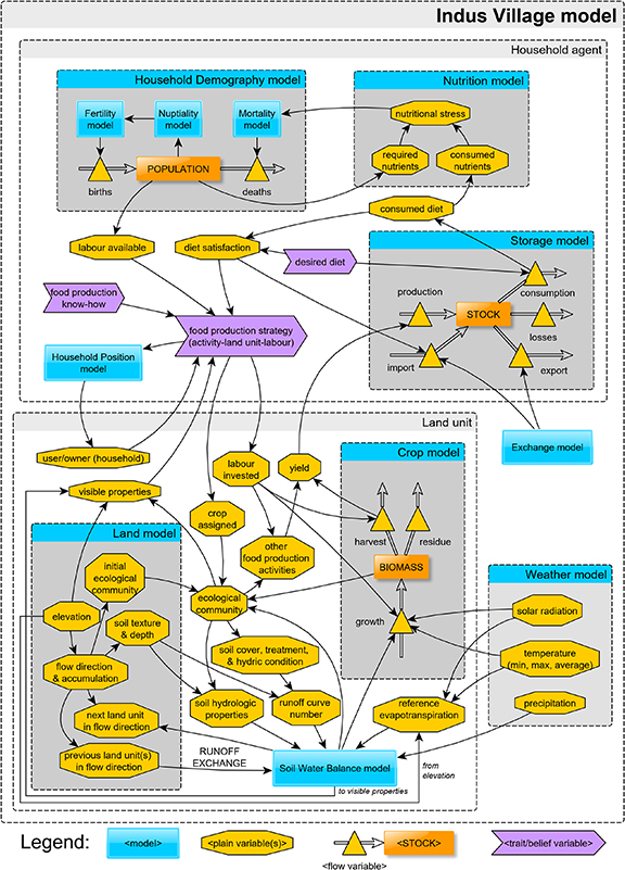
Figure 5. Outline of the dependencies of variables and sub-models of the Indus Village model (parameters are not represented).
Download figure:
Standard image High-resolution imageThe scale of the area represented in the model will be one of the aspects explored in future simulation experiments. However, both the model and experiments are being design for the scale of the direct land use of an agricultural village (c. 25 km2 or 2500 ha).
The entire model is to be run with a time step of a day, though most processes occur only under certain conditions: some are active during a continuous sequence of days, such as crop growth (from sowing to harvest), while others are solved discretely after certain events, one or more times in a year, such as the selection of production strategies. The general flow of the model describes a population of farming households and their members, settling or re-settling within the local area, choosing a food production strategy and the corresponding land use and labour investment, and managing and consuming the produce. The household re-evaluates the production strategy seasonally, guided by an average diet desired, while the actual consumption of nutrients affects the probability of death of individual members.
The core of the model lies in between the workings of the sub-models. Seasonally, household agents will compare their desired diet, expressed as a composition of foodstuffs, to the diet realised during the last yearly cycle (the last two cropping seasons), and either continue or modify their production strategy accordingly. Changes in the production strategies can involve selecting other available land units, shifting the activities or crops assigned to currently used land units, or redistributing the labour invested in those land units. The stress on diet satisfaction and, consequently on the stability of strategies, can be alleviated by acquiring foodstuffs through exchange with external actors. Figure 5. Outline of the dependencies of variables and sub-models of the Indus Village model (parameters are not represented).
5.4. Modularity and progressive development
All models used within the Indus Village model are purposely kept as independent components. Modularity allows for a paced and cleaner improvement of each model and even their eventual replacement by a competing model. Additionally, significant effort and discipline are being put into developing multiple versions that, though progressively more complex, are revised, tested, and documented. In this way, we hope to improve the intelligibility of their outcomes and guarantee that these models survive the project, remaining accessible for future replication or re-use.
The development of the Indus Village model is ongoing, but it has consolidated several sub-models. These sub-models were implemented in NetLogo, which is an open-source software platform for modelling and simulation specialised in ABM (Wilensky 1999). NetLogo was considered the best option for delivering compact sharable models within the short term. All files related to the Indus Village model and its sub-models are stored under version control in a public repository (https://github.com/Two-Rains/indus-village-model) and have been released as a citable repository (Angourakis 2020a).
5.5. Environmental sub-models
5.5.1. Weather model.
A relatively simple model whose function is to simulate daily weather variables required by the Soil Water Balance and Crop models. Daily solar radiation (MJ m−2) and temperature (°C) (average, maximum and minimum) are simulated using a sinusoid function (controlled by the annual minimum and maximum) with daily normal noise (controlled by daily standard deviation). Daily precipitation (mm) is derived from the annual curve of accumulated precipitation, which is simulated using a double-logistic function (Shabani et al 2018) followed by a stochastic algorithm to break the curve into stepped slopes in order to obtain discrete precipitation events. This was selected as the best parametric approach able to recreate the pattern found in most of the Indus River Basin and particularly Haryana (i.e. two rain seasons; see model study in Angourakis 2020b). This approach requires the annual total precipitation and six other shape parameters that control the two seasons' timing, spread and relative proportion of annual precipitation. To simulate interannual variability, the curve is re-generated every year with normal noise applied for all parameters. Reference evapotranspiration (mm) is calculated through the Penman-Monteith method, using the grass cover reference and assuming a constant wind velocity of 2 m s−1 (Allen et al 1998). While all other weather model variables are assumed homogeneous throughout the space of the model, reference evapotranspiration is influenced by terrain elevation. See example of the Weather model outputs in figure 6.

Figure 6. Example of the combined output of the Weather, Soil Water Balance and Crop sub-models for a single land unit for 5 years (5 × 365 d). The Weather model outputs are solar radiation, average daily temperature, precipitation, reference evapotranspiration (ETr) (see parameter setting in Angourakis 2020c). The proportion of soil water content (WATp) and the ARID index are calculated using the Soil Water Balance model (parameter values from Wallach et al , pp 138–144). The bottom plot shows crop biomass (solid lines) and fraction returned as harvest yield (dashed lines) for wheat (Triticum) and rice (Oryza) simulated by the Crop model (parameter values for Yecora Rojo and IR72 cultivars in Zhao et al 2019, Table 1a).
Download figure:
Standard image High-resolution image5.5.2. Soil Water Balance model.
A dynamic systems model originally developed by Woli et al (2012) for computing the ARID and further documented and implemented in R by Wallach et al 2014, pp. 24–28 and 138–144). This model calculates daily changes in soil water table in order to obtain ARID, depending on the balance between inflows (precipitation, runoff in, irrigation) and outflows (transpiration, runoff, deep drainage). ARID reflects patterns of both overall intensity and calendar distribution of precipitation. For instance, because of differential transpiration, winter rainfall will normally have a longer effect easing aridity than the same amount of rainfall during summer (figure 6).
5.5.3. Land model.
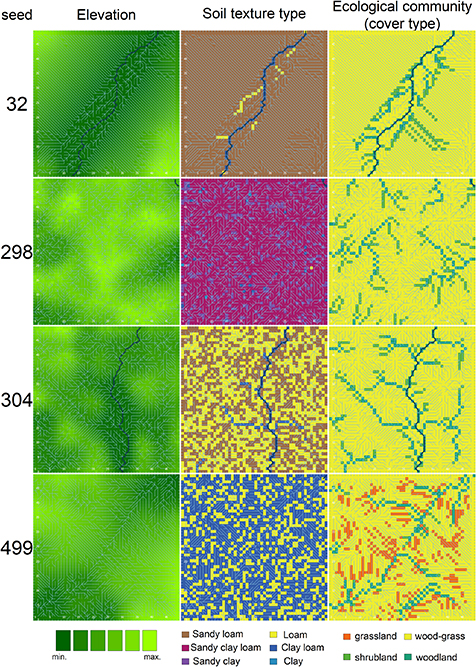
A procedural generation engine to generate collections of terrain grid masks to be imported into simulation experiments (section 5.3). This model first generates the elevation of land units through a series of algorithms aimed at emulating the terrain of alluvial plains at a local scale. Flow direction and accumulation are derived following a standard algorithm used in GIS (Jenson and Domingue 1988, Huang and Lee 2015). As a proxy of long-term erosion and deposition of materials, flow accumulation is used for estimating soil depth and textural composition (percentages of sand, silt and clay) using four sigmoid functions, to which normal noise is added. Soil texture is then used to determine the soil water conditions required by the Soil Water Balance model by cross-referencing soil texture type in external tabulated data. As a proxy of long-term water availability, flow accumulation is also used to set the composition of initial ecological communities (percentages of grass, brush and wood vegetation) using three logistic functions constrained by the premise of ecological succession (wood takes preference over brush and grass, and brush over grass). The initial ecological community determines the climax state in a land unit, with no water stress (ARID = 0) and when not allocated to crops or animal grazing. The ecological community at any given time is to be used as a visible property factored in the Household Position model and the allocation of land use. Figure 7 shows a few examples of the terrain data generated by the Land model. To combine the outputs of the Weather and Land models and provide ARID as input to the Crop model, an extension was created to account for surface water horizontal dynamics (runoff exchange in figure 5), based on a simplified flow transmission algorithm (Yang et al 2018) (see the video included in Angourakis 2020c, showing an one-year simulation of this integration of sub-models).
Figure 7. Examples of 50 × 50 terrain masks generated by the land model emulating local terrains (25 km2, i.e. 1 land unit = 1 ha) in the Indus Basin. Blue lines show direction and intensity of water flow. Soil texture types refer to the USDA's classification based on percentage of sand, silt and clay (USDA 1987). Ecological communities is a classification based on percentage of grass, shrub/brush and wood vegetation; it translates into cover types used by the USDA to tabulate runoff curve numbers (Cronshey 1986, table 2.2). The terrain random number generator seed (right) controls the setting of parameters within predefined ranges and all other stochastic procedures in the Land model (see parameter setting of these examples in Angourakis 2020c).
Download figure:
Standard image High-resolution image
5.5.4. Crop model.
An adapted version of the dynamic crop model, named SIMPLE, proposed by Zhao et al (2019). This model is executed in each land unit used for crop cultivation. It calculates daily crop biomass (figure 6), receiving weather variables, ARID coefficient and labour invested as inputs and accounting for crop properties as parameters based on contemporary datasets (range of sowing and harvest dates, potential harvest index, base and maximum temperature for growth, thermal age required for each stage of development, radiation use efficiency and its sensitivity to drought and extreme heat). At harvest time, it delivers yields to be stored as foodstuff stocks by the corresponding household. The SIMPLE crop model greatly simplifies several aspects known to influence crop growth (e.g. root and leaf growth, soil fertility), and its results must be evaluated with caution. However, its parsimony allows for more clarity in the first version of the Indus Village model.
5.6. Population and economy sub-models
5.6.1. Storage model.
A simple model of stored foodstuff that accounts for inflows (production and import/acquisitions) and outflows (consumption, losses due to expiration and export/distribution). The yearly product of each type of foodstuff (e.g. wheat grains) is controlled as separate stocks.
5.6.2. Nutrition model.
A model that calculates an index of nutritional stress using the quantities of each type of nutrients required and consumed by each household member. The output, the index of nutrition stress, is used by the Household Demography model to modify the age- and sex-specific probability of death.
5.6.3. Household Demography model.
A demographic model that applies modelled life table age- and sex-specific probabilities to individuals within households for giving birth, marrying, and dying, and handles the repercussions of these events. The output of the Household Demography model, i.e. the size and age/sex composition of households (referenced as 'POPULATION' in figure 5), are inputted into the calculation of the available labour hours and the required nutrients.
5.6.4. Household Position model.
A model representing the hypothetical rationale of households when deciding a location to settle. Factors in this model include quality of land available, path cost distance to water source and to other household bases.
5.6.5. Exchange model.
A model that handles the exchange of foodstuff between households and simulates the supply and demand of each product from outside the locality, assuming the existence of a regional exchange network. By representing external supply and demand, this sub-model will allow controlled experiments regarding the sensitivity of village-level subsistence systems to its integration into a broader economic system.
6. Experimental design
Simulation models are often characterised as 'virtual laboratories' because simulation experiments follow the same rationale of real-world experiments (Winsberg 2010). In both cases, experiments replicate what is deemed essential of a system to test hypotheses about its behaviour. In contrast to observing the original system directly, experiments are, by definition, repeatable and executable under controlled conditions. In contrast with direct observations, experiments are designed to operationalise hypotheses, minimising the influence of unknown and confounding variables.
The Indus Village model include all elements we considered necessary to replicate the key features of the system of interest—i.e. the food economy of Indus Civilisation villages. Among these elements, parameters, i.e. variables controlled externally, play a central role in setting the conditions for expressing our guiding hypotheses as simulation experiments. However, before approaching hypotheses with simulation experiments, it is important to perform an exhaustive sensitivity analysis. Such a necessary step consolidates the understanding of each parameter's effect over a selected group of variables and can help focus or redirect experiments.
Experiments will address our guiding hypotheses by monitoring different variables related to the controlled variation of specific parameters. Although the experimental design is still evolving during model development, hypotheses will be tested through the following general criteria:
- 1.Urbanism is the product of a complex system. This hypothesis is at the root of our modelling approach and serves as an assumption for all other hypotheses. Because of that, it is possibly beyond the testing scope of a model representing a single settlement. However, this hypothesis can be illuminated by observing population growth in the Indus Village while varying the amount and diversity of the external supply and demand of foodstuff (parametrised in the Exchange model). Such an experiment would be interpreting population growth as a factor in urbanisation and foodstuff supply and demand as proportional to exchange opportunities.
- 2.Local diversity hinders settlement rural-urban differentiation. We will tackle this hypothesis with an experiment monitoring population growth while exploring the systemwide food production know-how, limiting the maximum number of different food production strategies at any given time. Through this experiment it will be possible to observe the demographic consequences of extreme commitment to mono-crop cultivation and compare it to various forms of multi-cropping. This experiment will need to be run under different environmental scenarios, multiple times, to verify that the demographic effects attributed to food production diversity are not due to environmental differences.
- 3.Favourable conditions relax adaptation/Unfavourable conditions strengthen adaptation. Once the effect of food production diversity in population growth is understood, another set of experiments will then observe both population growth and food production diversity under varying conditions of water availability. The two sources of water in the model, precipitation and river inflow, must be explored separately and then together in order to discern their potential interaction. Following this first batch of experiments with stable conditions, the two mirrored hypotheses can be approached through varying parameters during simulations (i.e. climate change scenarios). For example, by starting a simulation with a low average of annual precipitation (unfavourable condition; expected adaptation through diversification) and raising this parameter to a significantly higher level (favourable condition; expecting relaxation of adaptation through more risky and high-yielding strategies) over a predefined transition period.
- 4.The exchange network collapses. As with the first hypothesis, to adequately address the impact of food production diversification in exchange networks between settlements would require scaling up the Indus Village model. Nevertheless, we believe essential insights might be gained by observing population growth and foodstuff exported under controlled conditions of food production diversity (systemwide know-how). Assuming that the modelled village is not an outlier, the level of foodstuff exported would indicate how many exchange opportunities exist within the exchange network.
- 5.The subsistence crisis led to migration and abandonment of cities. Even though the hypotheses concerns cities, we can use the Indus village model to address it by assuming that the Exchange model represents an exchange network that includes cities. Under this assumption, the hypothesis can be tested by observing foodstuff exports under decaying environmental conditions (aridification). However, the hypothesis (and ultimately our 'testable narrative') would not be confirmed if an exports decrease is not accompanied by changes in the local diversity of food production strategies.
7. Validation plan
Validation of archaeological computational models can have important pitfalls, such as uncertainty and equifinality (Brouwer Burg et al 2016). In planning this process, the concern in the Indus Village model has focused on the danger of circularity and model overfitting, which has been a valid criticism for many iterations of ABM.
The validation of the model will necessarily be an open-ended process as it is ultimately dependent on the quantity and quality of the data in the archaeological record. As in most modelling applications in archaeology, the data required for validation to be statistically convincing is a promise that may never come. There will always exist large areas of uncertainty to be filled by assumptions to interpret the data, which often are not extracted from direct and repeatable observations.
When approaching socio-environmental systems, it may appear methodologically sound to run all simulation experiments using empirical data on one well-documented location. The obvious advantage would be to skip the added complexity of simulating these data, reducing the parameter space of the model significantly. Such a line of reasoning would then suggest that, after performing a sensitivity analysis on the remainder of the model, simulation runs could be directly compared with variables estimated from archaeological data and thus calibrated and validated through error-measuring and optimisation techniques. However, without the possibility of varying the conditions fixed on the input data, there is little guarantee that the conditions producing trajectories approximating the archaeological record are not an artifact of the specific dataset introduced.
We aim to avoid this pitfall by simulating terrains and weather variables through parametric models, i.e. the Land and Weather models. Their inclusion allows us to explore a large set of conditions that are comparable but not equal to real datasets. With this strategy, it becomes possible to assess the effect of certain parameters through sensitivity analysis that otherwise would not be visible, e.g. the total annual precipitation or the presence and inflow of a passing river. We believe this type of verification to be an important step before validation, particularly when ground-truthing may be unfeasible or take years of re-focused research.
Our ambition regarding calibration and validation is to first characterise overall simulation results qualitatively through simulation experiments, in order to test the narrative guiding the modelling process. In a later phase, advancing towards validation, the model will be run under the range of conditions estimated for the archaeological sites and periods studied by TwoRains. Using paleoclimate proxies to calibrate the Weather model will be a promising path to explore. The site-specific simulated trajectories would then be compared to the available archaeological data, and model validation techniques will be applied discretionally. The lines of evidence currently considered for validation are site-level estimated ranges of population, either as individuals or households, and the relative proportion of archaeobotanical remains attributed to distinctive crops, as an approximation of their weight in dietary composition.
8. Conclusion
History and archaeology have proved invaluable in investigating social resilience and transformation in the face of climate change. We argue that the case of the Indus Civilisation can illuminate the potential differences between urban and rural communities facing aridification. Indus archaeology offers a myriad of lines of evidence on this subject, which is unfortunately seldom unified. In TwoRains, we take this necessary synthesis as an essential requirement, achievable only through intensive interdisciplinary work.
The Indus Village model represents an ongoing effort in joining contextual knowledge, consolidated and ongoing datasets, assumptions, and narratives developed in multiple disciplines into a single coherent 'virtual laboratory'. To guide the modelling process, we have defined a set of hypotheses or 'testable narratives' about the process leading to the floruit and decay of Indus Civilisation cities. This narrative proposes that increasing precipitation led to higher investment in fewer high-yield crops, boosting exchange and urbanisation, while, later, aridification favoured greater diversity and more resilient low-yield crops, reducing the opportunities for exchange and rendering cities unsustainable. After an exhaustive sensitivity analysis of the model parameters, we will use the Indus Village model to test the various components of this guiding narrative by performing a series of experiments relating parameters to specific effects in variables. Armed with these experimental results, the last open-ended step will be to ground the model with the available archaeological and paleoclimate data to address hypotheses within specific Indus Civilisation sites.
Although ambitious in its scope and complexity, the model is intended to be rigorous, controllable, and intelligible at all stages of development. Additionally, by keeping its design modular and public, we aim to guarantee its usefulness to future models and generations of modellers. We believe that simulation approaches, such as the one presented here, are essential for promoting model-based science, emphasising the development of better explanations and enforcing the foundations for better policies and practices.
Acknowledgments
This paper was made possible thanks to funding from the European Research Council (ERC) under the European Union's Horizon 2020 research and innovation programme (grant agreement no 648609) for the TwoRains project (www.arch.cam.ac.uk/research/projects/two-rains). TwoRains is a collaboration between researchers at the University of Cambridge and Banaras Hindu University in Varanasi that was begun as the Land, Water and Settlement project (www.arch.cam.ac.uk/research/projects/land-water-settlement/). We would also like to acknowledge funding from the DST-UKIERI programme and the McDonald Institute for Archaeological Research. Meteorological data used in figure 3 were obtained from the NASA Langley Research Center (LaRC) POWER Project funded through the NASA Earth Science/Applied Science Program (https://power.larc.nasa.gov/). The attributions regarding graphic assets used in figure 4 are as follows: all emojis are by Twemoji licensed under CC-BY 4.0 (https://github.com/twitter/twemoji); cube representing land units is by OpenClipart-Vectors (pixabay.com) under Creative Commons Zero License for Public Domain, available at www.needpix.com/photo/100634/block-grass-earth-land-green-grass-free-vector-graphics-free-pictures-free-photos-free-images; icon depicting a mother with an infant is by the CDC (U.S. federal government) and is in the public domain (available at https://commons.wikimedia.org/wiki/File:Mother_wtih_infant_icon.svg); pottery icons are under Creative Commons Zero License for Public Domain and were obtained at svgsilh.com; 'people' icon by Fahmihorizon under CC-BY 3.0 obtained at https://thenounproject.com/icon/1426355/; the central 3D scene was created by A. Angourakis. All remaining graphic assets used in figure 4 are in the public domain. Certain images in this publication have been obtained by the author(s) from the Wikipedia/Wikimedia website, where they were made available under a Creative Commons licence or stated to be in the public domain. Please see individual figure captions in this publication for details. To the extent that the law allows, IOP Publishing [and full partner name (if applicable)] disclaim any liability that any person may suffer as a result of accessing, using or forwarding the image(s). Any reuse rights should be checked and permission should be sought if necessary from Wikipedia/Wikimedia and/or the copyright owner (as appropriate) before using or forwarding the image(s). Certain images in this publication have been obtained by the author(s) from the Pixabay website, where they were made available under the Pixabay License. To the extent that the law allows, IOP Publishing disclaims any liability that any person may suffer as a result of accessing, using or forwarding the image(s). Any reuse rights should be checked and permission should be sought if necessary from Pixabay and/or the copyright owner (as appropriate) before using or forwarding the image(s).
Data availability statement
No new data were created or analysed in this study.