

Abstract
Aircraft activity is expanding across Arctic Alaska, potentially changing social-ecological systems. Arctic communities report that aircraft disturb wildlife and negatively influence harvest practices and experiences. Limited data have restricted knowledge about the extent of aircraft activity over traditional harvest areas. Our objective was to use soundscape monitoring methods to document aircraft overflights around the rural subsistence-based community of Nuiqsut to inform impact mitigation processes. This study provides the first quantitative estimates of aircraft activity in rural Arctic Alaska. We deployed 20 acoustic monitoring systems in summer 2016 along travel corridors used to harvest caribou (Rangifer tarandus). Sound recordings captured 7465 aircraft events during peak caribou harvest season. Aircraft activity reached a median of 12 overflights per day near human development, approximately six times greater than undeveloped areas. Aircraft noise decreased incrementally with distance from human development. Given that subsistence harvesters report that aircraft startle caribou and prefer to avoid aircraft themselves, this result implies that they will need to travel farther for a successful harvest, incurring higher costs of fuel, equipment, and effort. Such costs could be prohibitive for many harvesters. Our research demonstrates that acoustic data can aid in understanding how human-to-human interactions impact social-ecological dynamics in the Arctic.
Export citation and abstract BibTeX RIS
1. Introduction
Beginning with industrial-scale oil extraction in the 1970s, the negative impacts of small aircraft activity on local wildlife and traditional hunting have been one of the largest, most frequent, and ongoing concerns expressed by rural communities in Arctic Alaska (USAED 1996, USDOI BLM 1997, 2003, SRB&A 2009, USDOI BLM SAP 2010, ICAS 2014, NPR-A Working Group 2014, 2015, NSB 2015, 2017). Aircraft-hunter conflict has remained unresolved partly because of limited data on the extent and characteristics of small aircraft traffic in the region. Regulatory agencies, namely the Federal Aviation Administration, have no plans to generate such data. Public land agencies document take-offs and landings for permitted aircraft within their jurisdiction (USDOI BLM 2017), but these data provide little information about flight paths or private operations over rural residents hunting lands. Therefore, we collaborated with rural community residents to design and implement a new approach to this decades-old problem. Specifically, we applied a soundscape ecology technique to quantify aircraft activity over the traditional caribou (Rangifer tarandus) hunting areas of a rural arctic community.
Soundscape ecology offers an innovative means to understand how anthropogenic activity impacts remote ecosystems like the Arctic. A soundscape has been defined as the aggregate pattern of abiotic, biotic, and anthropogenic sounds that emerge from a given landscape (Ambrose and Burson 2004, Farina 2012, Mullet et al 2016). Analyzing the composition of soundscapes can estimate the impacts of anthropogenic noise sources on wildlife and human communities (Swanson 2002, Barber et al 2010, Pijanowski et al 2011, Francis et al 2017).
Rural community residents regularly report that aircraft activity affects their traditional harvest success by startling caribou (USDOI BLM SAP 2015, SRB&A 2017). Most empirical acoustic research has examined the impacts of anthropogenic noise on avian and marine wildlife, with terrestrial mammals receiving less attention, particularly in the high Arctic (Stinchcomb et al 2019). A few studies confirm that caribou flee and become restless when exposed to low-flying aircraft (Calef et al 1976, Maier et al 1998). Some additional evidence suggests that caribou tolerate aircraft outside of the calving period; however, chronic exposure to noise may exert indirect effects on wildlife fitness, especially during high-stress seasons when the energy expended to avoid aircraft could otherwise be invested in reproduction, offspring development, or foraging (Murphy and Curatolo 1987, Luick et al 1996; Reimers and Colman 2006, Stankowich 2008). If long-term caribou responses to aircraft mirror responses to other industrial and motorized activity, herds could be displaced from their historical range (Braem et al 2011) and change the timing of their seasonal migration (Mahoney and Schaefer 2002). The traditional knowledge of Arctic community Elders suggests that caribou herds no longer pass through areas of heavy industrial activity or historical river crossings (SRB&A 2017).
For human communities, soundscapes carry culturally constructed meanings that contribute to their sense of place, spirituality, and cultural identity (Lashua 2006, Chandola 2013). The frustration that Arctic indigenous communities express towards aircraft may be explained, in part, as an interruption of cultural practices that are closely tied to the natural environment (i.e. subsistence activities). Based on a survey of hunters in the rural indigenous community of Noatak, Alaska, Halas (2015) reported that 72% of locals perceived that aircraft reduced the quality of their hunt.
By startling wildlife, diverting their movements, or frustrating the hunter, aircraft disruption of harvest practices could undermine the well-being, cultural traditions, and cultural identity of rural Arctic communities (Smith et al 2009). The diversion of caribou can also reduce food availability and access for these communities (USDOI BLM 2017, SRB&A 2017). During a scoping meeting near Nuiqsut, Alaska in 1996, a local resident spoke of their hunt for caribou being disrupted by aircraft activity:
'we see a helicopter, maybe two or one or two of them, just flying around after chasing the caribous back out there. So I take everybody, went home with empty—no food, no meat, nothing' (unknown, USAED (U.S. Army Engineer District, Alaska) 1996).
Hunters continue to report that they avoid areas where aircraft frequently occur (SRB&A 2017). Such avoidance could result in the loss of traditional hunting lands and their associated oral histories (USDOI BLM 2003).
Aircraft-hunter-caribou interactions exhibit substantial spatiotemporal variability, complicating empirical efforts to understand causal relationships (Vistnes and Nellemann 2008). The limited availability of data on small aircraft in Arctic Alaska further restricts researchers' ability to study when, where, and how much aircraft activity occurs over traditional harvest areas during peak hunting seasons. Despite the widespread and long-standing concerns of rural Arctic communities, peer-reviewed research has yet to investigate how subsistence practices respond to aircraft activity (Stinchcomb et al 2019).
Here, we used acoustic monitoring methods (Lynch et al 2011) to document an Arctic soundscape and monitor aircraft activity in critical caribou hunting areas around the rural Arctic community of Nuiqsut, Alaska. This research was implemented in response to a request by the Kuukpik Subsistence Oversight Panel, a board of Nuiqsut residents that provides a representative voice on local issues and reviews outside efforts that could affect community activities (e.g. subsistence harvesting). Our study was exploratory rather than hypothesis-driven with objectives to (i) collect baseline data on aircraft activity over Nuiqsut's caribou harvest areas during Summer 2016; and (ii) examine how aircraft expands the 'footprint' of human activity in a relatively remote and inaccessible part of the world.
We provide the first quantitative estimates of small aircraft activity in Alaska's high Arctic that will help inform the longstanding concern of rural Arctic communities about the impacts that aircraft exert on their traditional ways of life. As aircraft-dependent activity expands across remote Arctic regions (Carr et al 2013), this issue is increasingly contentious among diverse stakeholders. Our use of acoustic data to address aircraft disturbance therefore has broad implications for understanding human interactions in the Arctic that affect the dynamics of tightly coupled social-ecological systems.
2. Methods
2.1. Study area
Nuiqsut (70.2175° N, 150.9764° W) is a rural community in Arctic Alaska (figure 1), located approximately 29 km inland from the Arctic Ocean on the Colville River Delta. The population of Nuiqsut (n = 411, US Census Bureau 2016) is 89% Alaska Native Inupiat (NSB (North Slope Borough) 2015). During the summer (Jun–Sep), Nuiqsut residents use the Colville River system (figure 2) for access to fish and wildlife resources (Braem et al 2011, SRB&A 2017). Caribou represent the most highly harvested terrestrial species in total usable kilograms per year (47 600 kg yr−1, Brown et al 2016). The surrounding landscape is flat, low-lying tundra broken by a patchwork of lakes and waterways in the summer (Jun–Sep) and covered by snow and ice in the winter (Oct–May). Local temperatures range from −49 to 26 °C with 297 d below freezing (NSB (North Slope Borough) 2015).
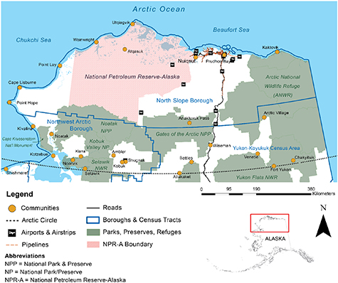
Figure 1. Map of Arctic Alaska, including the North Slope and Northwest Arctic Boroughs, and part of the Yukon-Koyukuk Census Area. Infrastructure is largely clustered in the northeast around oil developments expanding from Prudhoe Bay to Nuiqsut. Pictured airports and airstrips are public and multi-use facilities. Each community also has a local airstrip used primarily for transportation and cargo services. Source layers were derived using public data from the Bureau of Land Management (BLM) Arctic Office, Alaska State Geospatial Clearinghouse, National Parks Service Integrated Resource Management Applications (IRA) data store, and the U.S. Census Bureau.
Download figure:
Standard image High-resolution image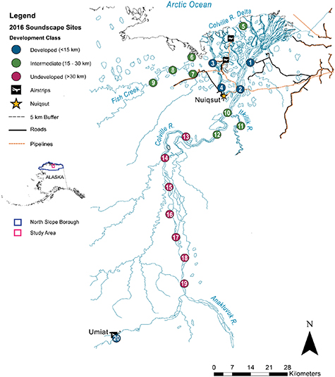
Figure 2. Map of our 2016 soundscape study area in the Colville River region of northern Alaska, including the rural community of Nuiqsut. Soundscape monitoring sites were deployed in the summer 2016 to capture aircraft disturbance over Nuiqsut's traditional caribou harvest areas, primarily the Colville River corridor and its tributaries. For analysis, sites were grouped by mean distance from village and industry infrastructure (i.e. airstrips and drill sites) on the Colville River delta ('Development Class'): Developed (less than 15 km), Intermediate (15–30 km), and Undeveloped (over 30 km). Development classes are indicated by the color of the site points. Airstrips on the Colville River delta are associated with oil drilling sites, and the airstrip at Umiat on the southwest edge of our study area is used primarily for research and management activities. Source layers were derived using public data from the Bureau of Land Management (BLM) Arctic Office and the Alaska State Geospatial Clearinghouse.
Download figure:
Standard image High-resolution imageOil and gas developments partially envelop Nuiqsut around the Colville River delta, overlapping with high-use traditional harvest areas. Aircraft transport equipment and workers among industry associated airstrips throughout the area. A small airport also exists in Nuiqsut, serving passenger and cargo flights, some private planes, and scientific research efforts. The peak of industrial, commercial, and research activities involving aircraft aligns with the Nuiqsut community's peak harvest season for caribou (Jun–Sep).
2.2. Acoustic monitoring methods
To quantify aircraft activity and noise levels over Nuiqsut's traditional harvest area during peak caribou harvest season, we collected acoustic data from 20 monitoring systems thatrecorded from June to August 2016. We collaborated with Nuiqsut community organizations and a Tribal entity (e.g. Kuukpik Subsistence Oversight Panel, Caribou Subsistence Monitoring Panel) to establish our monitoring sites every 10 km along traditional harvest corridors (figure 2, table S1 (https://stacks.iop.org/ERL/15/115005/mmedia)). For analysis, we classified our sites into 'development classes' by mean distance from Nuiqsut and the surrounding industry infrastructure (i.e. airstrips and drill sites) on the Colville River delta. Developed sites were less than 15 km from development, Intermediate sites were 15–30 km from development, and Undeveloped sites were over 30 km from development (figure 2). We accessed our monitoring sites using local boat guides, rather than an aircraft that may contribute to the community's frustration. Consequently, restricted access to some sites resulted in recording variable recording lengths among our 20 sites. We obtained full recordings (80–84 d) from six sites and partial recordings (51–76 d) from four sites; nine of the remaining sites recorded for 21–41 d (table S3).
For our recording systems, we utilized a consumer-grade digital audio recorder (Roland R-05, Roland Corporation 2010, Los Angeles, CA) calibrated to provide absolute sound pressure level (SPL) measurements (Mennitt and Fristrup 2012). The device was elevated 1.5 m (5 ft) above ground on a galvanized steel pole, protected by a windscreen constructed with plastic garden wire surrounded by 2.54 cm (1 in) pile faux fur fabric, and topped with a plastic pot saucer for rain dispersion (figure 3). The systems recorded continuous environmental sound for 26–30 d at a time, before we visited the sites to collect data cards and exchange batteries. Systems remain deployed for approximately 3 months (Jun–Aug).
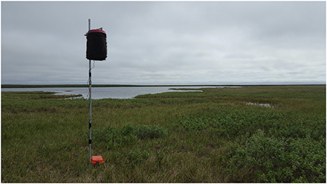
Figure 3. Example of an acoustic monitoring system deployed near Nuiqsut, Alaska to capture aircraft activity. A Roland R-05 Digital Audio Recorder is hung securely from a galvanized steel pole, protected by a windscreen, and wired to a battery system at the base (protected by a waterproof case). These systems monitored continuous environmental sound from Jun–Aug 2016, for 26–30 d at a time until data cards and batteries needed to be replaced.
Download figure:
Standard image High-resolution imageUpon data card collection, raw recordings had to be converted from SPL data to NVSPL files (NPS/Volpe format) that parse the recording into hourly data and translate it into a format that can be read by acoustic analysis software and visualized into spectrograms (NPS 2013). To identify aircraft sound events, we conducted audiovisual analysis of hourly spectrograms using the Sound Pressure Level Annotation Tool (SPLAT) from the Acoustic Monitoring Toolbox version 1.05591 (NPS 2008), following protocols outlined by the NPS (Lynch et al 2011). We defined one aircraft event as an unbroken period over which aircraft signals are audible above background noise by the human listener. Although two events may be the same aircraft, we considered each event as one instance of aircraft disturbance. During audiovisual analysis, we were able to reliably discriminate between three types of aircraft: high-altitude jet, propeller plane, or helicopter. We annotated each event with a source code according to these types (table S2). During the summer, most hunters in Nuiqsut use watercraft to access caribou hunting areas. We therefore annotated watercraft signals during audiovisual analysis and extracted the same metrics to facilitate a comparison with aircraft.
2.3. Quantifying aircraft disturbance
We compared aircraft disturbance across the three development classes: developed sites (<15 km from development); intermediate sites (15–30 km from development); and undeveloped sites (>30 km from development). We consider two components of 'disturbance': activity (number of events) and noise (magnitude of sound). We chose total aircraft sound events, median aircraft events per day, median sound exposure levels (SELs; the total acoustic energy of a noise event), and median daily noise-free intervals (NFIs; the amount of time between two aircraft events) to characterize aircraft disturbance, summarized over each development class. As a reference for aircraft noise levels, we characterized the natural component of the soundscape using Natural Ambient Sound Level (Lnat), a standard estimate for the level of environmental sound that would exist in the absence of human-derived noise. We provide detailed definitions of these metrics in our supplemental materials. We used a combination of Python v 3.5.1 and R v 3.2.4 (R Development Core Team 2016) to extract these metrics for each site and summarize those metrics over each development class.
To visualize median NFIs across the study area, we used the Kernel Interpolation with Barriers tool in the Spatial Analyst toolbox in ArcMap 10.4.1 (Esri Inc. 2016). The resulting heat map provides a preliminary estimation of aircraft noise disturbance over space (figure 4(a)). We caution that the Kernel Interpolation method does not account for sound attenuation and considerable data gaps exist west of Nuiqsut and over 50 km upriver. We therefore recommend that the spatial interpolation of median daily NFIs should always be interpreted with reference to the prediction standard error map (figure 4(b)).

Figure 4. (a) Estimated distribution of median noise-free intervals (NFIs) over the study area generated by Kernel Interpolation with Barriers in ArcMap 10.3. Disturbance level is presented on a scale from cool color (blue, long NFI and low disturbance) to warm and hot color (red, high disturbance). Red areas experience the shortest intervals between aircraft events, and thus the greatest potential disturbance. The corresponding prediction standard error (b) must be considered when interpreting this heat map. Standard error is lower around sites that are clustered together and which recorded for the longest periods. Data are especially limited for sites 6–9 and 16–19 (see table S1).
Download figure:
Standard image High-resolution image3. Results
Acoustic monitoring systems captured a total of 7465 aircraft events from 03 June to 28 August 2016 (table 1). We found aircraft activity to be concentrated around human development, where median events reached 11 aircraft per day (table 1). In undeveloped areas, event rates dropped to one aircraft event per day, whereas activity at intermediate sites fell between developed and undeveloped levels, with a median of seven events per day (table 1).
Table 1. Metrics of aircraft and watercraft disturbance from 2016 soundscape monitoring sites around the Colville River region in northern Alaska. Site-based data was summarized across three regions: developed (<15 km from infrastructure), intermediate (15–30 km from infrastructure), and undeveloped (>30 km from infrastructure). We report aircraft event rates, sound exposure levels (SELs), noise-free intervals (NFIs) in each region. We provide median absolute deviation (MAD) as an index for variability of each disturbance metric. Lnat is the existing ambient sound level in the absence of aircraft activity and serves as a baseline environmental condition.
| Range Median Lnat (dBA)a | Total Events | Median Daily Events | MAD Daily Events | Median SEL (dBA) | MAD SEL (dBA) | Max SEL (dBA) | Median NFI (h) | MAD NFI (h) | |
|---|---|---|---|---|---|---|---|---|---|
| Aircraft | |||||||||
| Developed (n = 5) | 33.8–40.2 | 4046 | 12 | 6.4 | 64 | 8 | 94 | 0.5 | 4 |
| Intermediate (n = 7) | 25.3–47.4 | 2839 | 7 | 4.7 | 60 | 8 | 101 | 1 | 4 |
| Undeveloped (n = 7) | 28.9–37.8 | 565 | 2 | 1.8 | 58 | 7 | 103 | 13 | 15 |
| Average, all sites b | n/a | 7465 | 6 | n/a | 61 | n/a | 89 | 5 | n/a |
| Watercraft | |||||||||
| Developed (n = 5) | 33.8–40.2 | 1397 | 5 | 4 | 65 | 6 | 89 | 1 | 9 |
| Intermediate (n = 7) | 25.3–47.4 | 865 | 3 | 3.2 | 63 | 8 | 96 | 1 | 16 |
| Undeveloped (n = 7) | 28.9–37.8 | 668 | 2 | 1.4 | 61 | 7 | 84 | 2 | 40 |
| Average, all sites b | n/a | 2930 | 2 | n/a | 62 | n/a | 79 | 4 | n/a |
a dBA = A-weighted decibels, a standard unit of sound pressure normalized to human hearing. bAverage median value, except for Total Events which is summed across sites.
The median NFI, or time between subsequent aircraft events, in developed environments was less than 1-h long. The shortest observed median NFI (0.5 h, or two aircraft every hour) occurred close to the Nuiqsut community at sites situated between industry airstrips (table S3). Our heat map shows that NFI durations increased incrementally with distance from the developed Colville Delta (figure 4(a)). A region 50–80 km upriver from Nuiqsut experienced the most quietude, with estimated NFIs between 13 and 22 h (figure 4(a)). Comparing two 24-h spectrograms from a developed and undeveloped site with equal recording days (sites 3 and 15, figure 2) exemplifies the clear difference in aircraft activity levels between these areas (figures 5(a), (b)).

Figure 5. Sound visualized in 24-h spectrograms for developed (a) and undeveloped (b) sites on the same recording day. The difference in aircraft activity is apparent with 20 aircraft signatures can be seen at the developed site (#3, figure 2) compared to 4 visible at the undeveloped site (#15, figure 2) over a 24-h period. Aircraft sound events are annotated by white boxes. Each row of the spectrogram spans 2 h of the day, with sound frequency (Hz) mapped on the vertical axis of each row. Sound pressure is represented by color on a spectrum of blue (low pressure, perceived quiet) to yellow and white (high pressure, perceived loudness). Spectrograms are presented in A-weighted decibels to correct for human hearing.
Download figure:
Standard image High-resolution image
Aircraft median SEL ranged from 55 to 69 dBA (table S3) and exceeded Lnat levels by 26–32 dBA at 60% of our sites (n = 12). The maximum aircraft SEL observed was 103 dBA from a helicopter flying over an undeveloped site (Site 15, table S3). Individual aircraft SELs, however, varied considerably across the study area due to the distance of the aircraft from the sound monitor and environmental conditions such as wind or rain.
Median watercraft sound levels (range median 61–65 SEL dBA) were similar to aircraft sound levels (range median SEL 58–64 dBA) across the study area (table 1). However, maximum watercraft SELs only exceeded 90 dBA in one case, whereas maximum aircraft SELs exceeded 90 dBA at 40% of our sites (table S3). Watercraft were detected most frequently around the developed Colville delta at a rate of five events per day (table 1).
4. Discussion
We are the first to successfully document aircraft noise around a remote Arctic environment that is important to indigenous hunters. Local areas within 15 km of Nuiqsut and nearby oil and gas development infrastructure experienced the greatest disturbance from aircraft. The difference in aircraft activity between such developed sites and intermediate (15–30 km from Nuiqsut) sites with the same recording period was negligible (table S3). Therefore, we suggest that a 30 km radius around infrastructure may represent the existing boundary for high aircraft disturbance.
Activity levels within 30 km of Nuiqsut were similar to local civil operations over the same time period at airports in the western and central plains regions of the United States (e.g. Jackson, Wyoming and Grand Island, Nebraska) as well as Hilo, Hawaii, and Juneau, Alaska (FAA 2020; for details about this comparison, see supplementary materials). Locally, these airports serve an average human population of 40 189 people,1 95 times the population size of Nuiqsut. Although indirect, this comparison demonstrates that Nuiqsut may be experiencing a level of aircraft traffic reflective of a substantially larger and more populated location. A more careful and extensive analysis, however, would be required to directly compare aircraft activity magnitudes.
Still, we speculate that aircraft activity during our study period may have been lower than preceding and subsequent years. Crude oil prices dropped to a 15-year low in early 2016, which likely reduced industry and state-sponsored activity in the area. Since our study, oil lease sales and development have expanded considerably in relatively undisturbed areas to the west and southwest of Nuiqsut (BLM 2020a). As these and other developments proceed across the Alaskan Arctic, including the recently approved leasing of coastal lands in the Arctic National Wildlife Refuge (BLM 2020b), we expect aircraft use and disturbance to intensify over the traditional subsistence lands of multiple rural Arctic communities.
Watercraft disturbance paralleled the pattern of aircraft disturbance, declining over 30 km away from development. Our use of local-hired boat drivers for transportation limited our site locations to the river corridor, biasing our data towards higher detection of watercraft as opposed to other motorized noise sources. However, watercraft occurred at 30% the rate of aircraft in developed and intermediate regions. Low watercraft activity in undeveloped regions remains consistent with lower caribou harvest activity on the upper Colville (SRB&A 2017). These data suggest that Nuiqsut hunters typically travel on land and river less than 30 km from the community.
The harvest area of highest use therefore overlaps with the highest aircraft activity that we documented, which could have consequences for continued subsistence practices. Since harvesters frequently report that they avoid areas of high aircraft traffic due to the startling of caribou as well as their own frustrations with noise (USAED (U.S. Army Engineer District, Alaska) 1996; SRB&A 2017), our results suggest that harvesters will have to travel more than 30 km from Nuiqsut to avoid future aircraft encounters. Traveling farther upriver generates additional costs for the harvester including time, spare equipment, and watercraft fuel (Moerlein & Corothers 2012, Brinkman et al 2014). It also introduces safety concerns, as traveling farther for longer time periods increases vulnerability to mechanical breakdown in areas where rescue is complicated and challenging (Clark et al 2016, Christie et al 2018). These costs may be prohibitive for many members of the community, leading to a few well-equipped harvesters embarking on intensive trips to take multiple animals and share the harvest when they return (Magdanz et al 2002, Wolfe et al 2009). An increasing reliance on these 'super households' may lead to a loss of traditional harvest lands, a weakening of sociocultural networks, and a rise in community vulnerability to environmental change (Herman-Mercer et al 2019, Burnsilver et al 2016, Baggio et al 2016).
Our findings indicate that hunters who travel farther from development are less likely to encounter an aircraft. Yet our data also show that undeveloped sites exhibited the largest difference between median and maximum aircraft SELs, suggesting that a single aircraft encounter could exert a greater impact in distant, undeveloped areas as compared to developed areas near the community. This implication aligns with acoustic monitoring research from the western U.S., which found that remote environments have begun to experience long periods of audible anthropogenic noise, including aircraft overflights (Lynch et al 2011). The quietest soundscapes may thus be more vulnerable to future aircraft disturbance than those already subject to high aircraft and human traffic (Penland 1989; Lynch et al 2011). Such increasing and sustained disturbance of environments where anthropogenic noise has typically been absent can affect wildlife diversity, distribution, and behavior across taxa (Barber et al 2010, Buxton et al 2017). Recent research has demonstrated that some wildlife populations in Arctic Alaska, including caribou, are unlikely to habituate to anthropogenic activity and infrastructure (Johnson et al 2020). Small noise disturbances (i.e. 3–10 dB) can also degrade human experiences in nature and contribute to frustrations with motorized noise, as quietude strongly contributes to hunter and recreator satisfaction (Mace et al 1999, Heberlein 2002). Considering that aircraft-hunter conflict has persisted for nearly 50 years in the Arctic, it is unlikely that rural community residents will habituate anytime soon (Stinchcomb et al 2019).
5. Conclusions
We are just beginning to understand how acoustic data can inform social-ecological research and management. By capturing anthropogenic activity, acoustic data can refine landscape-scale analyses on impediments to hunter and wildlife movements (Mcrae et al 2008, Fullman et al 2017). Although it remains clear from local community testimonies that aircraft noise is affecting hunter experiences and raising concerns about its effects on wildlife, causal relationships among aircraft activity, hunter movements, and caribou responses cannot be determined due to insufficient data on all variables at the same time in the same place. Therefore, following the current study, research was implemented during 2019 (NSF award # 1839192) across Alaska's North Slope using a grid of 40 acoustic recorders and trail cameras to explore the relationship between sound and caribou occupancy in the region. Eventually, experimental designs with auditory treatments will be needed to provide a more precise understanding of causation between noise and behavioral response of caribou. As human activity and development expand across Arctic regions, determining the resulting acoustic footprint will be necessary to conserve quiet refugia for both humans and wildlife.
Studies that incorporate acoustic data offer an opportunity to closely couple social and ecological dynamics. Since our systems are low-cost and user-friendly, they could be implemented in communities across Alaska that share a longstanding concern of anthropogenic disturbance to their subsistence practices (Stinchcomb et al 2019). Engaging local people in soundscape research could facilitate the decision-making process by enhancing the relevance and legitimacy of scientific efforts to local communities (Meadow et al 2015). Under rapid climate change, political pressure to develop the Arctic, and movements for indigenous rights, integrated acoustic research will help us understand the cumulative impacts of human activity on Arctic ecosystems and cultures. This knowledge is critical to balancing the needs of diverse user groups in preserving the integrity of Arctic social-ecological systems.
Acknowledgments
We would like to thank the community of Nuiqsut, Kuukpik Subsistence Oversight Panel, Inc., and many local hunters for collaborating with us and kindly sharing their time and knowledge. Funding for our research was provided by Alaska NSF EPSCoR Award #OIA-1208927 and the state of Alaska. We received additional financial and logistical support from the Institute of Arctic Biology and the Resilience and Adaptation Program at the University of Alaska Fairbanks, and the Bureau of Land Management Arctic Field Office. The findings and conclusions in this article reflect those of the authors and do not necessarily represent the views of the Bureau of Land Management nor the National Parks Service.
Data availability statement
The data that support the findings of this study are available upon reasonable request from the authors.
Footnotes
- 1
City, State (Airport code): Palm Springs, CA (PSP); Idaho Falls, ID (IDA); Pendleton, OR (PDT); Jackson, WY (JAC); Garden City, KS (GCK); Grand Island, NE (GRI); Lawton, OK (LAW); Port Arthur, TX (BPT); Hilo, HI (ITO); Juneau, AK (JNU).