

Abstract
Changes in the Yangtze River level induced by large-scale human water regulation have profound implications on the inundation dynamics of surrounding lakes/wetlands and the integrity of related ecosystems. Using in situ measurements and hydrological simulation, this study reveals an altered Yangtze level regime downstream from the Three Gorges Dam (TGD) to the Yangtze estuary in the East China Sea as a combined result of (i) TGD's flow regulation and (ii) Yangtze channel erosion due to reduced sediment load. During the average annual cycle of TGD's regular flow control in 2009–2012, downstream Yangtze level variations were estimated to have been reduced by 3.9–13.5% at 15 studied gauging stations, manifested as evident level decrease in fall and increase in winter and spring. The impacts on Yangtze levels generally diminished in a longitudinal direction from the TGD to the estuary, with a total time lag of ∼9–12 days. Chronic Yangtze channel erosion since the TGD closure has lowered water levels in relation to flows at most downstream stations, which in turn counteracts the anticipated level increase by nearly or over 50% in winter and spring while reinforcing the anticipated level decrease by over 20% in fall. Continuous downstream channel erosion in the near future may further counteract the benefit of increased Yangtze levels during TGD's water supplement in winter and accelerate the receding of inundation areas/levels of downstream lakes in fall.
Export citation and abstract BibTeX RIS

Content from this work may be used under the terms of the Creative Commons Attribution 3.0 licence. Any further distribution of this work must maintain attribution to the author(s) and the title of the work, journal citation and DOI.
1. Introduction
China's Three Gorges Dam (TGD), thus far the world's largest hydroelectric project (Nilsson et al 2005), initialized water impoundment in June 2003. In less than one month, the water level of the Yangtze River immediately upstream of the TGD was elevated by more than 50 m (to 135 m above the Yellow Sea Datum), creating the Three Gorges Reservoir (TGR) and submerging ∼500 km upstream (China Three Gorges Construction Yearbook (CTGCY) 2004). The Yangtze River downstream from the TGD (figure 1(a)), a total length of ∼1600 km constituting nearly 30% of this longest river in Asia, has since been regulated under an altered flow regime (Gao et al 2013).
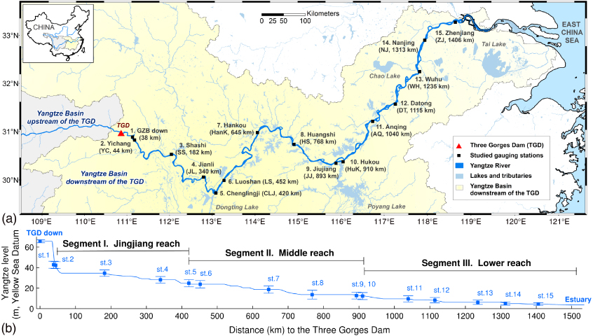
Figure 1. (a) The Yangtze hydrologic basin downstream of the Three Gorges Dam (a total area of 784 000 km2, accounting for 44.6% of the entire Yangtze Basin) and studied gauging stations. (b) Longitudinal profile of average station elevations. Station distances to the TGD were geodesic distances manually measured along the associated Yangtze segments on GoogleEarth and Landsat images. The conventional definition of the Yangtze middle reach includes both Jingjiang reach (Segment I) and middle reach (Segment II) classified in this study.
Download figure:
Standard image High-resolution imageIn a typical annual cycle, Yangtze outflow from the TGD is controlled under four water dispatch modes, namely, (i) pre-discharge dispatch: TGR water release in late May–early June for the preparation of downstream summer flood control, (ii) flood-control dispatch: flow adjustment in July–August, (iii) water-storage dispatch: water impounding in mid-September–October for the preparation of electricity generation and water supply in winter, and (iv) water-supplement dispatch: water release in January–March (CTGCY 2004, Ou et al 2012). Such a dispatch scheme has been gradually adopted with yearly intensified water regulation since TGR's initial impoundment (i.e., June, 2003) (figure 2(a)). Correspondingly, the maximal TGR level reached in each water-storage dispatch mode steadily increased from ∼135 m in 2003–2005, ∼155 m in 2006–2007, ∼170 m in 2008–2009, to the maximal capacity level of 175 m since 2010 (figure 2(b)).
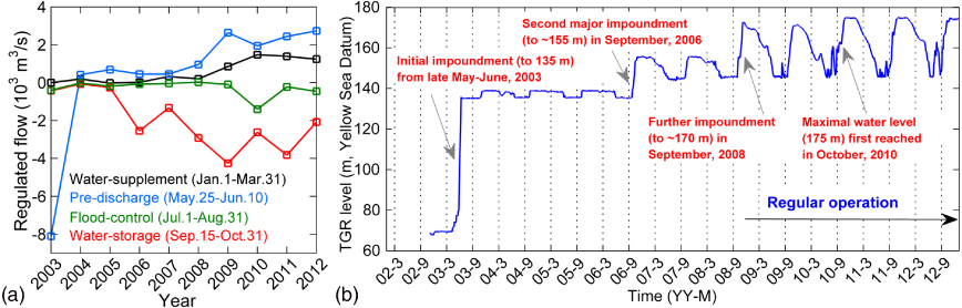
Figure 2. (a) Annual means of TGD flow regulation (m3 s−1) (i.e., outflow subtracting inflow) under different water dispatch modes; (b) daily TGR levels (m) during 2003–2012. Daily measurements of TGD flows and levels were acquired by the China Three Gorges Corporation (www.ctgpc.com.cn).
Download figure:
Standard image High-resolution imageAs with some other largest hydroelectric projects, the TGD has received worldwide attention due to its profound impacts on downstream hydraulics, channel morphology, and ecological systems (Fearnside 1988, Li 2009, Tullos 2009, Qiu 2011, Sun et al 2012). The Yangtze Basin downstream of the TGD is a critical ecoregion that contains ∼40% of freshwater lake area and ∼30% of freshwater marsh/wetland area in China (estimated from the Global Lakes and Wetlands Database by Lehner and Döll (2004)). As the majority of these lakes and wetlands are located in the Yangtze floodplain, their inundation levels and areas interact with local Yangtze levels (Yin et al 2007, Guo et al 2012), which vary predictably with changing flows (Leopold and Maddock 1953). TGD regulation, typically described as flow decrease in fall while increase in winter and spring, interfered with the natural seasonality of downstream Yangtze levels and thus river–lake interactions (Hu et al 2007, Guo et al 2012, Ou et al 2012, Zhang et al 2012, Liu et al 2013).
Concurrent with TGD's flow regulation, a considerable amount of sediment in the upstream Yangtze flow (e.g., ∼60% in 2003–2006 estimated by Xu and Milliman (2009)) has been retained in the TGR, leading to decrease of sediment load released from the dam and long-term geometric/morphologic changes (e.g., erosion) to the downstream Yangtze channel (Yang et al 2007, Xu and Milliman 2009, Li et al 2009, Cheng et al 2011, Dai and Liu 2013). Channel-derived sediment in the downstream reach did not completely offset the sediment loss in the TGR (Yang et al 2007). Continuous channel erosion due to sediment supply deficiency in turn lowers Yangtze water levels in relation to flows, complicates anticipated level changes induced by flow regulation, and therefore further impacts the integrity of the surrounding riparian environment and ecosystems.
Existing studies of TGD's downstream impacts have primarily focused on (i) the alteration of Yangtze flows (Dai et al 2008, Xiao and Chen 2011, Gao et al 2013), (ii) the decrease of sediment transport rate and the consequential channel degradation/erosion (Yang et al 2006, 2007, Hu et al 2009, Li et al 2009, Xu and Milliman 2009, Cheng et al 2011, Dai and Liu 2013), and (iii) the change of inundation level/area of individual lakes in the riparian zone and their water exchange with the Yangtze main stem (Hayashi et al 2008, Dai et al 2010, Feng et al 2011, Huang et al 2011, Zhao et al 2011, Feng et al 2012, Guo et al 2012, Lai et al 2012, Liu et al 2013). Assessments of TGD's impacts on Yangtze River levels are limited to part of the downstream segment or small fractions of time periods (Zhou 2010, Huang et al 2011, Lai et al 2012, Sun et al 2012), and are lacking a longitudinal depiction of the intra-annual patterns of downstream levels altered by TGD's flow and sediment regulation.
Here we present a first systematic assessment of the TGD influence on the seasonal regime of Yangtze River levels immediately downstream from the TGD water-control system to the Yangtze estuary, by comparatively quantifying the impacts of two major outcomes of TGD operation: (i) regulated Yangtze flow and (ii) concurrent channel erosion due to reduced sediment load. Specifically, the analysis was targeted to address three scientific questions currently under inadequate investigation in the literature. First, in what magnitude has TGD's regular flow regulation influenced the downstream Yangtze level: e.g., how does the influence compare to natural level variability in typical annual cycles? Second, how has the magnitude and time lag of the influence vary from the TGD to the estuary? Third, how much has riverbed erosion in the downstream Yangtze channels further complicated (i.e., counteracted or reinforced) the seasonal level changes induced by TGD's flow regulation? Given the essential importance of Yangtze levels in the downstream hydrology, findings of this study provide scientific implications on the extended investigation of TGD-induced impacts on the dynamics and sustainability of Yangtze-connected lakes, wetlands and related ecosystems. The quantitative relations between TGD's flow regulation and downstream Yangtze levels provided here also facilitate the policy making of potential adaptation strategies for Yangtze level changes as well as the practice of downstream flood control, water supply, and navigation management.
2. Data and methods
To diagnose TGD's influences on the complete downstream reach, we selected 15 gauging stations along the Yangtze River with a total length of 1406 km (figure 1). These stations start from the downstream side of the Gezhouba (GZB) dam (st. 1) and end with Zhenjiang (st. 15) near the Yangtze estuary to the East China Sea, and are divided into three major segments (termed as Jingjiang, middle, and lower reaches) defined by Chenglingji (st. 5) and Hukou (st. 10) at the outlets of China's two largest freshwater lakes, Dongting and Poyang, respectively. Three sets of stations are found in very close proximities (<50 km), located immediately downstream from the GZB (i.e., 6 km between st. 1–2) and near the upstream/downstream edges of large lakes (i.e., 32 km between st. 5–6 and 17 km between st. 9–10). Excluding these short distance intervals, the studied stations are distributed along the downstream Yangtze River with an average interval of 119.4 (±36.5) km. The GZB dam, part of the Three Gorges water-control system, is a small afterbay located 38 km downstream from the TGD, with limited storage capacity of ∼4% of the TGR's (CTGCY 2004, China Yangtze Power Co., Ltd 2013). Its primary function is to adjust the tail water flow from the TGD and improve navigation conditions of the Yangtze segment between the two dams. Flow regulation by the GZB is negligible as verified by high agreement of daily outflows from both dams (see figure S1 in the supplementary methods, available at stacks.iop.org/ERL/8/044012/mmedia). Daily water levels at downstream GZB (st. 1) and TGD inflows/outflows were acquired from the China Three Gorges Corporation (www.ctgpc.com.cn). Daily measurements of both levels and discharges at st. 2–15 during 2004–2012 were acquired from the Yangtze Waterway Bureau (www.cjhdj.com.cn).
We formulated two hypothetical scenarios to account for the influences of TGD's flow regulation and Yangtze channel geometric changes, respectively: (i) a non-regulation scenario assuming no flow regulation from the TGD (i.e., natural flows) but changing/realistic downstream channel geometries, and (ii) a static-channel scenario assuming no flow regulation and constant downstream channel geometry since the year 2004. Specifically, the non-regulation scenario aims to replicate natural downstream levels during the post-dam period when downstream channel erosion still likely occurred due to continuous sediment deposition in the impounded TGR, while the static-channel scenario further removes the influence of channel geometric changes on the non-regulated downstream levels.
The hydrological model PCR-GLOBWB (Van Beek et al 2011, Wada et al 2011, 2013) was applied to simulate regulated (Qr) and natural (Qn) daily Yangtze flows during 2004–2012. Daily amounts of flow regulation exerted on each station (ΔQ) were calculated as Qr subtracting Qn, and corrected by flow time lags identified from daily series of observed levels between stations. Simulated ΔQ are subject to uncertainties caused by complex interactions between the Yangtze main stem and adjacent large lakes/tributaries which were not considered by our model. Thus, our calculated Yangtze level changes are approximations of the potential influences of TGD's flow regulation; such level changes tend to be reduced by river and river–lake hydrodynamics at the cost of further impacting lake/wetland inundation patterns (refer to the supplementary methods). To capture channel geometric changes at each station, stage–discharge rating curve for individual years in 2004–2012 were established as compound power-law functions (Leopold and Maddock 1953) fitted to the observed daily levels and discharges. However, our acquired discharge record was limited to st. 2, 3, 6, 7, 9, and 12; daily discharges at the other stations (st. 4, 5, 8, 10, 11, 13–15) were estimated by model simulations calibrated by observed discharges at nearby stations. For these stations, yearly rating curves were established using observed levels and simulated discharges (see table S2 for fitting statistics, available at stacks.iop.org/ERL/8/044012/mmedia). All station discharges were further adjusted using observed levels to reduce erroneous level estimations caused by backwater and unsteady flows (Chow 1959). Natural discharges were calculated as adjusted station discharges added by simulated ΔQ. Station water levels under the non-regulation scenario were hence estimated from natural discharges and yearly rating curves, while levels under the static-channel scenario were recovered from natural discharges and the rating curves of 2004. The static-channel scenario was not performed at Huangshi (st. 8) due to absence of level observations prior to 2010, nor at Nanjing (st. 14) or Zhenjiang (st. 15) due to complicated ratings likely caused by amplified uncertainties of flow simulations. The detailed method and estimation uncertainties are elaborated in the supplementary methods.
3. Results and discussion
Station levels in both hypothetical scenarios (non-regulation and static-channel) were calculated on a daily basis for 2004–2012. We here emphasize the period of regular TGD operation since 2009 (refer to figure 2) in order to assess the full influence of flow control on the downstream Yangtze levels. The average annual variations of daily station levels in 2009–2012 are provided in figure 3, while the corresponding daily and seasonal station level changes are presented in figures 4 and 5, respectively.
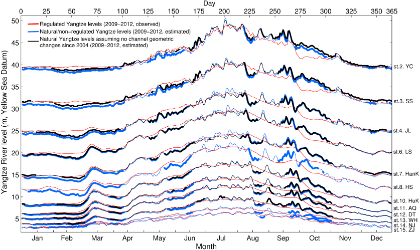
Figure 3. Average annual variations (2009–2012) of daily Yangtze levels under the regulated/realistic and hypothetical scenarios at selected gauging stations. Days with significant differences from the regulated levels on a 10-day scale are thickened. Level changes at Huangshi (st. 8) were assessed in the years 2010–2012 due to lack of observations prior to 2010.
Download figure:
Standard image High-resolution image
Figure 4. (a) Average annual relative regulation intensities of flows and levels (2009–2012) in the classified downstream Yangtze segments; (b) average annual variations of TGD-induced level changes (2009–2012) at studied gauging stations. Days with significant differences on a 10-day scale are thickened. The time lag of TGD's influences between the downstream stations is illustrated by the dotted red lines. Due to close proximities to the neighbor stations, locations of st. 2, 6, and 10 are not to scale in the distance axis; travel rates of TGD's influences (reflected as the slopes of the dotted red lines) around these stations should be interpreted with caution.
Download figure:
Standard image High-resolution image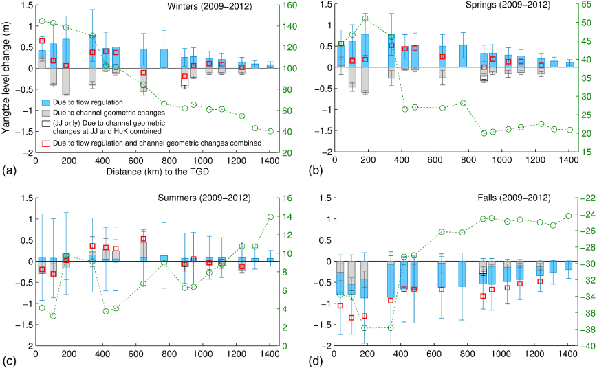
Figure 5. Seasonal profiles of TGD-induced level changes and relative regulation intensities at studied stations: (a) winter (December–January–February), (b) spring (March–April–May), (c) summer (June–July–August), and (d) fall (September–October–November). Error bars denote the standard deviations of daily levels in each season of the annual cycle averaged in 2009–2012 (2010–2012 at Huangshi, st. 8). The locations of st. 2, 6, and 10 are not to scale in the distance axis due to close proximities to the neighbor stations.
Download figure:
Standard image High-resolution image
3.1. Influence of flow regulation
The seasonality of downstream Yangtze levels was considerably altered by TGD's flow regulation, primarily reflected by the significant and persistent level changes under TGD's four major water dispatch modes (thickened lines in figures 3 and 4). In a regular annual cycle (e.g., the average of 2009–2012), the TGR started the preparation of electricity generation in the fall recession season (mid-September–October), elevating the water level from ∼145 m to the storage capacity maximum of 175 m in the water-storage dispatch mode. As a consequence, downstream Yangtze levels were decreased by 27.5–45.9% of the natural annual level variations at the studied stations (see figure 4(a) and the supplementary results, available at stacks.iop.org/ERL/8/044012/mmedia). We estimated additional level drops of 1.17 (±1.29) m and 0.97 (±1.05) m attributed to this dispatch mode at Chenglingji (st. 5) and Hukou (st. 10), the outlets of Lakes Dongting and Poyang, respectively. Such level decrease accelerated the water drainage of connected lakes and wetlands (i.e., the 'emptying effect'; Zhang et al (2012)), and partially contributed to the observed area decline of Lakes Dongting and Poyang in the recent fall seasons (Guo et al 2012, Feng et al 2013). The TGR level was steadily lowered to 155 m under the following water-supplement dispatch mode in January–March. This lowering corresponded to increased outflow from the TGD that elevated downstream station levels by 9.7–32.5% of the annual level variations and largely eliminated the natural minimum levels in late-February (figure 3). The TGR level was further decreased to the operation minimum level (145 m) under the pre-discharge dispatch mode in May–early June for the preparation of summer flood storage. Continuous flow release during this dispatch mode increased downstream station levels by 11.4–32.2% of the annual level variations, e.g., with additional rise of 0.62 (±0.56) m and 0.43 (±0.44) m estimated at Chenglingji (st. 5) and Hukou (st. 10), respectively. Such level rise tended to restrict tributary/lake outflow to the Yangtze River (i.e., the 'blocking effect' Hu et al 2007, Zhang et al 2012), leading to further increased lake areas during the spring rainy season in the downstream Yangtze Basin. The coming flood-control dispatch mode in July–August stabilized the Yangtze flows and helped mitigate flood pressure by reducing 12.7–27.2% of the natural summer fluctuation in the downstream station levels. The overall impact of TGD's flow regulation reduced the natural variation of downstream station levels by 9.1–13.5% in the Jingjiang reach (st. 1–4), 4.5–7.5% in the middle reach (st. 5–9), and 3.9–4.4% in the lower reach (st. 10–15). These influences (averaged for 2009–2012) are double to triple the influences averaged for 2004–2012, and can be considered as the full impact of TGD's flow regulation on the downstream Yangtze levels.
Although the seasonality of altered levels prevailed in the entire downstream Yangtze River, the occurrence time and magnitude of level changes varied among the selected stations. The occurrence time of level change relates to the travel time of TGD outflow as a function of distance and wave velocity. Our results indicate an average time lag of ∼9–12 d for any flow regulation at the TGD to impact the Yangtze flow/level near the estuary (table S1, available at stacks.iop.org/ERL/8/044012/mmedia). Magnitude of level change is determined by (i) the proportion of flow regulation relative to local Yangtze discharge and (ii) the sensitivity of level change to flow regulation associated with channel hydraulic geometry. Station observations revealed a stepwise accumulation of Yangtze flow downstream from the TGD (figure S5, available at stacks.iop.org/ERL/8/044012/mmedia), primarily demarcated by major tributary confluences, i.e., Chenglingji (st. 5), Hankou (st. 7, Han River confluence), and Hukou (st. 10); Yangtze flows in segments between and beyond these confluences stayed fairly constant with minor fluctuations. As a result, influence on the downstream level generally diminished with increased distance from the TGD (figures 3 and 4) while strengthened TGD influence in local segments (such as the Jingjiang reach) was mainly attributed to the variation of channel cross-sectional geometry, i.e., reduced width or increased gradients along the segment. Specifically, the maximum daily level drop under a regular water-storage dispatch mode (2009–2012) increased downstream along the Jingjiang reach from 2.89 m to 3.36 m, and then gradually decreased along the middle and lower reaches from 2.44 to 0.67 m. Similarly, maximum daily level increase under the water-supplement dispatch mode increased downstream along the Jingjiang reach from 1.11 to 2.09 m, and then declined along the middle and lower reaches from 1.42 to 0.23 m.
Such distance-decay patterns are also observed in the seasonal means of level changes summarized in figure 5. It is noted that despite the effect of flood mitigation, the Yangtze level means in summer slightly increased due to the baseline control of TGR's minimum operation level (145 m). The complexity of summer flow regulation was reflected by the large level variations. In addition to level changes, relative regulation intensities were calculated to compare the altered seasonal levels in proportion to natural seasonal variations. In winter, the regulated levels along the Jingjiang reach were constantly above the natural level fluctuation (intensities > 100% at st. 1–5). Although the influence was gradually weakened downstream, regulation intensity still exceeded 40% near the estuary. The consequential increase and decrease of downstream Yangtze levels, as regulated in spring and fall respectively, were generally in sync with the natural rise and fall of the downstream levels but ∼20–50% stronger.
3.2. Influence of channel geometric changes
Channel geometric changes have complicated the effects of TGD operation on the Yangtze levels beyond flow regulation. Instead of direct alteration of the Yangtze flow, channel geometric changes reshaped stage–discharge ratings and thus impacted the downstream levels in relation to flows. Since the TGD closure, gradually intensified flow regulation concurrent with continuous declines of downstream levels, particularly at low-flow stages, suggests a chronic process of channel scouring along the Yangtze River. As illustrated further in the supplementary results (figure S6, available at stacks.iop.org/ERL/8/044012/mmedia), we estimated that the channel erosion rate at the stage of the first-quartile flow during 2004–2012, for instance, decreases from 10.2–3.4 cm yr−1 downstream along the Jingjiang reach, 4.9–2.5 cm yr−1 along the middle reach, to 1.7–0.9 cm yr−1 along the lower reach. Despite the relatively slow erosion rates, riverbed degradation accumulated over multiple years could lead to significant discrepancy from the anticipated level influence of flow regulation alone.
We calculated the daily/seasonal Yangtze levels under the static-channel scenario for selected stations (shown in figures 3–5) in order to take account of the influences induced by channel changes erosion (manifested as additional level drop) throughout the cross-sectional channel profiles in the downstream Yangtze River. On the one hand, the substantial erosion in low-stage portions of the channel conflicted with the expected level increase under TGD's dispatch modes in winter and spring; on the other hand, erosion-induced level drops near middle-stage channel portions reinforced Yangtze level decline caused by the water-storage dispatch mode in fall. Compared to the natural flow levels in 2004, flow-induced level increments at the selected stations during 2009–2012 were counteracted by 15.1–123.6% in winter (9 out of the 12 assessed stations over 50%) and 11.6–79.4% in spring (9 stations over 30%), except downstream GZB (st. 1) where slight channel aggradation (∼0.25 m) occurred in its low-stage portion (figure 5). Particularly at Hankou (st. 7), the average winter level increase was completely counteracted by its deep channel scouring, resulting in a net level change of −0.11 (±0.29) m in winter. The spring 'blocking effect' for Lakes Dongting and Poyang were partially alleviated as indicated by the erosion-induced level drops at Chenglingji (st. 5) and Huku (st. 10) that respectively counteract 11.6% and 42.4% of flow-induced level increase. Conversely, channel erosion strengthened the anticipated Yangtze level decrease due to TGD's water storage in fall by up to 69.5% (8 stations over 20%). The fall 'emptying effect' for Lake Poyang was further reinforced as channel erosion at Hukou (st. 10) triggered another 22.8% of level drop (negligible erosion was detected at Chenglingji in fall). Supported by daily observation data, we noticed that water levels at Jiujiang (st. 9) were affected by both channel changes of its own and channel changes at Hukou. The considerable volume of tributary flow from Lake Poyang to the Yangtze through Hukou, constituting ∼15–45% of the local conflux, generated consistently strong backwater effects on the upstream vicinity and complicated the stage–discharge relation at Jiujiang (located ∼20 km upstream). As a result, Yangtze levels at Jiujiang were predominantly associated with Hukou levels, and subject to declines caused by channel degradation at both stations. Combining such dual effects, an average year-round net reduction (2009–2012) was identified for the Jiujiang Yangtze levels: from 0.00 (±0.19) m in spring to −0.83 (±0.58) m in fall (figure 5).
Similar to the flow-induced level changes, level changes caused by channel degradation generally reduced with increased distance from the TGD. This is attributed to the combined effects of recovered sediment load from the upstream and tributary sources, decreased flow regulation intensities, and wider or lower-gradient channel cross sections (associated with weaker incision/scouring effects of the flow on riverbeds). Intriguingly, the magnitudes of level changes caused by flow regulation and channel geometric changes tend to follow generally symmetrical patterns despite the exceptions of st. 4–6 and in summer. This suggests an intrinsic association between channel cross-sectional morphology and erosion rate: higher channel gradients are not only more sensitive to flow-induced level changes but also likely to undergo faster erosion. Except the distance from the TGD and channel morphology, the more complex longitudinal pattern of erosion-induced level changes (figure 5) implies many other important factors such as riverbed materials, the extent of local sediment supply, and the sediment transport capacity of the flow (Li et al 2009). For example, the negligible level changes at Chenglingji (st. 5) and Luoshan (st. 6) in both winter and spring implied certain degrees of channel aggradation during regular TGD operation, most likely through the increased sediment load from Lake Dongting (Xu and Milliman 2009, Li et al 2009)). However, this influence appeared rather regional; evident deep channel scouring continued from Hankou (st. 7) and was gradually weakened in the lower reach. Water levels at high-flow stages were subject to additional lifting (i.e., at subcritical flows) due to rising backwater downstream in the flood season. Thus, the estimated summer level increase (primarily at st. 4–7) may not necessarily indicate upper channel aggradation, and the erosion-induced level drops calculated in fall were considered to be conservative.
4. Summary and concluding remarks
We have shown an altered regime of the downstream Yangtze levels driven by two major outcomes of TGD operation: (i) regulated flows and (ii) degraded channels due to reduced sediment load. During the average annual cycle of TGD's full operation since 2009, the regulated Yangtze flow have reduced the natural annual variations of downstream levels by 3.9–13.5% among the studied gauging stations, primarily resulting from increased levels in winters (up to 0.20–2.09 m) and decreased levels in falls (up to 0.67–3.36 m). Level changes induced by flow regulation appeared to be magnified downstream along the Jingjiang reach and then gradually diminished in the middle and lower reaches, with a time lag of ∼9–12 d in total to reach Zhenjiang (st. 15) near the estuary. Chronic channel degradation concurred in the downstream Yangtze River, mostly substantial in the low-stage channel portions.
In general, the impacts of flow regulation and channel erosion were complementary in late summer and fall but conflicting in spring and winter, which had profound implications on the downstream hydrologic system. As of 2009–2012, channel erosion had counteracted nearly half or more of the anticipated level increments in spring and winter by at most studied gauging stations. While such deep channel erosion partially alleviated the 'blocking effect' on downstream tributaries and lakes in spring, it also reduced the potential benefit of level increase from the flow release in winter. In contrast, the accelerated drainage of downstream lakes/wetlands induced by TGR's water impoundment in fall, i.e., the 'emptying effect', was further reinforced by additional Yangtze level drop up to 69.5% (e.g., 22.8% at Hukou) triggered by concurrent channel degradation. Due to accessibility of data, the effect of channel changes was assessed relative to the benchmark levels in the year 2004 rather than the pre-dam period before June, 2003. Considering that channel degradation occurred immediately after the TGD closure (Dai and Liu 2013), our estimations of erosion-induced influences may be slightly conservative. Since TGD's flow control is already in full operation while channel erosion still remains as a chronic and continuous process, the impact of channel morphologic changes on the downstream Yangtze levels is anticipated to be further amplified and hence increasingly important in the future decades.
Acknowledgments
This work was supported in part by the USGS Landsat Science Team Program Grant (No. G12PC00071) to University of California, Los Angeles (UCLA). YW was financially supported by the Research Focus Earth and Sustainability of Utrecht University (Project FM0906: Global Assessment of Water Resources). The authors gratefully acknowledge Dr Laurence C Smith and Dr Michael E Shin at UCLA Department of Geography for the constructive suggestions on hydraulic theories, result implications, and graphic designs.