

Abstract
The western United States (U.S.) has been experiencing more severe wildfires, in part due to climate change, but the underlying synoptic patterns and their modulation in driving fire weather is unclear. Here we investigated the relationship between weather regimes (WRs) and fire weather indices, specifically vapor pressure deficit (VPD) and the Canadian Forest Fire Weather Index. By identifying five singular WRs using k-means clustering, we found that a particular regime (WR-2), one characterized by a distinct tripolar wave train pattern over the continental U.S., has exhibited an increased frequency since 1980. The ascribed WR-2 regime was found to be mainly responsible for rising trends in the fire weather indices, especially VPD. Further, the average fire indices of the WR-2 regime played a more important role than the frequency in shaping the rising trends in the fire weather indices. The increased frequency of the WR-2 WR was mainly attributed to anthropogenic forcing and, the year-to-year variation of the frequency was associated with sea surface temperature anomalies over the subtropical eastern Pacific. Human-induced climate change might have furthered the exacerbation of wildfire danger in the western U.S. by modulating the behaviors of WRs and fire weather indices.

Original content from this work may be used under the terms of the Creative Commons Attribution 4.0 license. Any further distribution of this work must maintain attribution to the author(s) and the title of the work, journal citation and DOI.
1. Introduction
Massive wildfires have become increasingly commonplace in the western United States (US) (Westerling et al 2006, Abatzoglou and Williams 2016, Abatzoglou et al 2021, Zhuang et al 2021), with resultant catastrophic impacts on human and animal habitats, air quality, the carbon cycle, water supply, as well as other runoff-related water hazards (Bowman et al 2009, Williams et al 2022, Chikamoto et al 2023). Prior research has demonstrated that observed temperature warming coupled with dryness have increased arid fire-season fuel risks, (Diffenbaugh et al 2015, Abatzoglou and Williams 2016, Williams et al 2019).
The danger of a wildfire incident occurring is generally quantified by the vapor pressure deficit (VPD) (Williams et al 2014, 2019, Abatzoglou and Williams 2016, Mueller et al 2020, Zhuang et al 2021, Varga et al 2022) and the Canadian Forest Fire Weather Index (FWI) (Van Wagner and Pickett 1985, Van Wagner 1987). Both the VPD and the FWI are expressed as functions of temperature and moisture (i.e. humidity), among other variables. The FWI, based on surface air temperature, relative humidity, rainfall and wind, has been widely used to quantify fire vulnerability across the world (Carvalho et al 2008, Dowdy et al 2009, Karali et al 2013, Jain et al 2017, Kirchmeier-Young et al 2017, Vitolo et al 2019). The aforementioned FWI ascribed variables are known to be modulated by weather regimes (WRs) defined as common, large-scale circulation patterns that have been widely used to characterize weather and climate (Robertson and Ghil 1999, Muñoz et al 2017, Vigaud et al 2018, Zhang and Villarini 2019, 2021, Zhang et al 2022). For example, WRs in the western U.S. are highly linked with specific patterns and variability of precipitation, temperature, humidity and winds (Robertson and Ghil 1999, Zhang et al 2022), as are those in the Midwest (Zhang and Villarini 2019), Northeast (Coe et al 2021) as well as within the Contiguous US (Francis et al 2018, 2022, Robertson et al 2020, Ratterman et al 2023).
The aforesaid offers the prospect that WRs may well serve to characterize fire weather danger. Previous studies have identified the relationship between WRs and wildfires, an example of which was conducted on the Spanish mainland by Rodrigues et al (2019). Other studies have also analyzed seasonal circulation patterns associated with wildfires in the northwestern U.S., western U.S. and California (Zhong et al 2020, Zhuang et al 2021, Chen et al 2023, Guirguis et al 2023).
To recapitulate, the western U.S. has witnessed an alarming increase in the severity and frequency of wildfires. It is postulated that a changing climate, that is now characterized by drier and hotter conditions, is in part driving the trend in wildfire frequency. However, only a few studies have been conducted in the West that have examined the association between daily WRs and wildfire variability, and more importantly, their modulation through anthropogenic forcing. Here we examine whether, to what extent, and how WR analysis is able to quantify fire weather danger across the West.
2. Data and methods
To explore the WRs connection to fire weather vulnerability/danger in the western U.S., we focused on the June to October period, i.e. the warm season. To further appreciate the impacts of large-scale circulation on wildfire danger, we also considered some regions beyond the western US. We utilized the fifth generation European Center for Medium-Range Weather Forecasts (ECMWF) Reanalysis ERA5 dataset at 0.25-degree spatial resolution at the hourly time scale to calculate the daily VPD and FWI; these were aggregated at the monthly scale (Hersbach et al 2020). We made use of the following ERA5's variables: temperature, relative humidity, rainfall, wind, and the 500 hPa geopotential height. Observed sea surface temperatures (SSTs) at 1-degree spatial resolution were obtained from the Hadley Center of the UK Met Office (Kennedy et al 2019). Inclusion of observed SSTs meant that we could examine the association between SSTs and the frequency of the WRs; this was done by regressing SSTs onto the WR frequency after detrending.
The Coupled Model Intercomparison Project Phase 6 (CMIP6) experiments were used for the attribution analysis given the increasing trend in the WRs frequency and analyzing VPD trends (Eyring et al 2016, p 6, Gillett et al 2016) as follows: (a) historical all forcing (HIST_ALL), (b) historical greenhouse gases (HIST_GHG) and, (c) historical natural forcing (HIST_NAT) (ref. table S1). In addition to the CMIP6 experiments, the Geophysical Fluid Dynamics Laboratory's Forecast-oriented Low Ocean Resolution version of CM2.5 (FLOR) control experiment (https://nomads.gfdl.noaa.gov/dods-data/FLOR/CM2.5/) was used to examine the circulation patterns associated with sea surface warming in the subtropical eastern Pacific (Vecchi et al 2014); this high-resolution fully-coupled model (∼50 km atmosphere) has been extensively evaluated over the past decade for its hydroclimate representation of the western U.S. (Vecchi et al 2014, 2019, Wiel et al 2016).
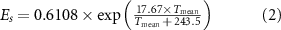
The Canadian Forest FWI, created by combining the Initial Spread Index (ISI) and the BuildUp Index (BUI), was determined using the following daily meteorological variables—surface air temperature, relative humidity, rainfall and wind (Van Wagner and Pickett 1985, Van Wagner 1987, Stocks et al 2011). Specifically, the calculation of FWI comprised daily total rainfall, and daily mean surface air temperatures, relative humidities, and winds. Three fuel moisture categories, or codes, were used in the FWI system; i.e., the Fine Fuel Moisture Code (FFMC), the Duff Moisture Code (DMC), and the Drought Code (DC). FFMC represents fuel moisture of forest litter fuels under the shade of a forest canopy; this is designed to represent moisture conditions for shaded litter fuels. DMC represents fuel moisture of decomposed organic material underneath the litter, and lastly DC represents drying deep into the soil. ISI is a combination of FFMC along with wind observations, while BUI is a combination of DMC and DC (Van Wagner and Pickett 1985, Van Wagner 1987). We calculated the daily FWI index from the ERA5 reanalysis data using the FWI system package in R (https://search.r-project.org/CRAN/refmans/cffdrs/html/fwi.html). VPD is the difference between the saturation vapor pressure and the actual vapor pressure. VPD is an important driver of atmospheric water demand for vegetation, and has been widely used to quantify fire weather across the world (Seager et al 2015, Williams et al 2019, 2020, Zhuang et al 2021); this was calculated by equation (1):

where Es and Ea represent saturation vapor pressure and actual vapor pressure respectively. Es is a function of dry bulb temperature and Ea was calculated using dew point temperature (Williams et al 2019, Chiodi et al 2021). VPD was calculated at the daily time scale of the ERA5 reanalysis data.
The calculation of Ea and Es from the Bolton equation were as follows:

where, (°C) is daily mean air temperature, and RH is relative humidity (%). The daily anomaly was defined as the deviation of the daily value from the long-term climatology on that day (1981–2010 in this study). Atmospheric aridity, as represented by the VPD, was calculated at the daily time scale of the ERA5 reanalysis.

As important drivers of the weather and climate, the WRs were defined as typical and recurrent synoptic patterns derived from 500 hPa geopotential height anomalies following previous studies (Robertson and Ghil 1999, Muñoz et al 2017, Vigaud et al 2018, Zhang and Villarini 2019, 2021, Zhang et al 2022). Previous studies have found the thermal dilation can affect the trend in 500 hPa geopotential heights (Horton et al 2015, Swain et al 2016), and consequently the frequency of WRs. To evaluate the thermal dilation contribution, we removed the linear trend in the 500 hPa geopotential height averaged over the globe prior to analyzing the WRs. The results with and without detrending were compared to evaluate the impacts of thermal dilation.
The average fire weather indices (FWI or VPD) for a particular WR were calculated as composite/average fire weather indices for the occurrence of the WR during a set period (e.g. a year). For example, average fire weather indices of the VPD for WR-1 in 1998 was calculated by averaging the VPD for the WR existence.
As large-scale circulation patterns exert strong impacts on meteorological variables such as rainfall, wind, temperature and humidity, the WRs were used to understand historical changes of FWI and VPD. We obtained the WRs by applying k-means clustering to the daily 500 hPa geopotential height anomaly fields based on the ERA5 reanalysis data and CMIP6 models. The k-means clustering uses Euclidean distance to quantify similarity. We use the 500 hPa geopotential height fields to derive the WRs because the 500 hPa geopotential height field better represented the processes in the mid-troposphere leading to changes in weather, and is a variable that represents both dynamic and thermodynamic processes (Christidis and Stott 2015). Many previous studies have used the 500 hPa geopotential height field to examine WRs over North America (McMurdie and Casola 2009, Horton et al 2015, Lee et al 2019, Liu et al 2023, Molina et al 2023). Previous studies have found that the 500 hPa geopotential height field can increase due to thermal dilation (Horton et al 2015, Swain et al 2016). Furthermore, to quantify the potential impacts of thermal dilation, we performed additional analysis of the WRs after detrending the 500 hPa geopotential height field. Based on a sensitivity analysis (Zhang and Villarini 2019) in which the number of clusters was assessed over a range four to seven, five clusters were selected, since the analysis indicated that four clusters were too few while six or seven became redundant in terms of resolving patterns.
To examine the significance of trends in the variables of interest, we applied linear regression analyses to assess the trends, and used the t-test to assess the P-value for the trends with the null hypothesis 'The trend is equal to zero'.
Given the variable Y = Y1 + Y2 + Y3 + Y4 + Y5, where Y is the mean VPD during June-October and Y1-5 represents the contribution of WRs1 to 5 to Y by determining the label of WRs on each day. The linear trend of Y (i.e. mean VPD) is equal to the sum of the linear trends of Y1, Y2, Y3, Y4 and Y5 respectively as follows:

where β is the linear trend (i.e. linear regression coefficient with respect to time) of the average VPD during June–October of 1980–2018, and β1-5 is the linear trend of VPD corresponding to WRs1-5 for the same period; this decomposes the trend of the mean VPD into the contributions of each WR, allowing us to understand the contribution of each WR to the historical trends of VPD or FWI.
Following previous studies (Cassano et al 2007, Horton et al 2015), we derived statistical methods to quantify the relative contributions of WR frequency and the average VPD of WR (average VPD over days with a specific WR) to the trends of VPD. The mean FWI (e.g. VPD; here as ) of all the WRs in June–October of a year can be represented as:

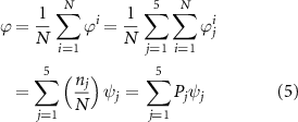
where N indicates the total number of WRs during June–October of a particular year, likewise denotes the number of WRs. is the VPD on a day during June-October. indicates the VPD on days that belong to a specific WR (i.e. 1–5). is the mean VPD for each WR. /, and indicates the ratio of the frequency of a WR to the total frequency of all WRs. The mean VPD for a specific WR (j) was represented as:


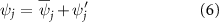

where denotes the climatological mean FWI for a specific WR, is the anomaly of the mean FWI, is climatological mean proportion of frequency of a WR to the total number of WRs, and is the anomaly of the mean proportion.


Substituting equations (6) and (7) into equation (5) results in:
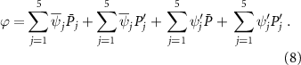
Applying the trend analysis to equation (8), we have:
where is the trend in FWI, the first term on the right represents the contribution from the frequency of WRs, the second term is the contribution from the changes in average FWI associated with WRs, and the third term represents the interactions between the first and second terms.

3. Results
3.1. Increasing fire weather vulnerability/danger
Increasing trends, averaged over June–October, in VPD and FWI were identified across the continental United States during the period of 1980–2018, but were significant and most substantial in the West (ref., figure 1). Overall, the regions with significant increasing trends, such as the Southwest, where the increases were of the greatest magnitude, demonstrated increases in FWI that are consistent with increases in VPD (ref., figure 1). Such upward trends in fire weather indices signify an increasing vulnerability/danger of wildfires, consistent with recent conflagrations in these regions (Dennison et al 2014, Holden et al 2018, Parks and Abatzoglou 2020, Chiodi et al 2021).

Figure 1. Trends in VPD (unit: hPa/year) and FWI (unit: values/year) during June–October for the period 1980–2020 using ERA5 data. Hatching represents trends that are statistically significance at the 0.05 level.
Download figure:
Standard image High-resolution image3.2. Weather regimes and fire weather
To elucidate the underlying factors contributing to the aforementioned notable trends and their modulation by WRs, we employed a k-means cluster analysis on ERA5 data to identify five distinct WRs (WR-1, WR-2, etc) from the daily 500 hPa geopotential height field anomalies (ref., figure 2). Building upon previous studies that examined WRs within the continental United States (Zhang and Villarini 2019, 2021), each WR was characterized by a specific mid-tropospheric pressure pattern (ref., right column figure 2): WR-1 was characterized by a ridge over the western region, and a trough in the eastern region in the 500 hPa geopotential height field. In contrast, WR-2 exhibited a tripolar pattern of ridge-trough-ridge. WR-3 displayed a meridionally muted pattern with a trough in the western region, and a ridge in the eastern region. WR-4 featured a meridionally amplified pattern with a pronounced trough in the western region, and a strong ridge in the eastern region. Lastly, WR-5 presented as a tripolar pattern with zonal trough-ridge-trough. The five distinct WRs provided a framework towards understanding the dynamic atmospheric conditions that influence fire weather patterns, and their contribution to the observed trends. The VPD anomalies associated with each WR exhibited distinct spatial characteristics, (ref., left column in figure 2). For the fire-related climate impacts, WR-1 was associated with high positive VPD anomalies, both in the western and southeastern U.S., and negative anomalies in the Great Plains and the Midwest. WR-2 was associated with positive VPD anomalies over the Pacific Northwest and California, negative VPD anomalies over the northern Great Plains, and overall positive anomalies over the northern U.S. By contrast, WR-3 exhibited negative VPD anomalies over the Pacific northwest and California, and positive anomalies over the southeast, and the Midwest. WR-4 showed negative anomalies over the western U.S., and positive anomalies over the eastern U.S. WR-5 depicts positive VPD anomalies in the U.S. except for parts of the southwest.

Figure 2. The anomalies of VPD (unit: hPa), FWI and 500 hPa geopotential height (unit: gpm) associated with the five weather regimes based on ERA5 data.
Download figure:
Standard image High-resolution imageBy and large, the FWI anomalies associated with the five WRs strongly bore a resemblance to the VPD distribution, albeit with slightly different localized features (ref., middle column in figure 2). The anomalies of FWI and VPD, associated with the five WRs, were consistent with precipitation and temperature anomalies (figure S1), implicating a drought linkage in those regions. The result presented also echoes the finding by Stuivenvolt-Allen and Wang (2022), i.e. that extratropical transitioning cyclones in the western North Pacific create a variety of WRs and associated fire weather fluctuations across North America. Note that the composites of VPD and FWI associated with the five WRs (figure S2) are different from the anomalies of the two indices associated with the WRs (figure 2).
Given prior discussions on VPD and FWI, we next examined the role of each WR's accountability in the growth of weather index trends across the western United States (see Methods). We focus on the WRs after the trends in the 500 hPa geopotential height field were removed (see Methods). In the western U.S., the WR2 regime accounted for the largest share of the increasing trends among the fire weather indices, while all the other WRs exhibited weakly positive or negative trends in VPD and FWI over the past few decades (ref., figure 3). Specifically, the fire weather indices associated with the WR1 regime exhibited no trend, while those concomitant with the WR3, WR4 and WR5 regimes have a marginally positive trend.

Figure 3. Trends in VPD (unit: hPa/year: Right) and FWI (values/year; Left) associated with the five WRs based on ERA5 data. The trends are calculated by summing fire weather indices corresponding to each weather regime divided by the total number of days for the June–October period of each year during 1980–2020, followed by linear regression fitting of the calculated annual fire indices onto years. The stippling represents trends that are statistically significant at the 0.05 level.
Download figure:
Standard image High-resolution imageGiven the dominant role of the WR2 regime in increasing fire weather vulnerability/danger in the western U.S., we further characterized the contribution of frequency and average fire indices of WRs for all the fire weather indices. Overall, the trends in the average fire indices (see Methods) of fire weather indices across the five WRs were similar and positive, although the WR2 regime exhibited a slightly higher average fire index compared to the other four WRs (ref., figure S3). Meanwhile, the frequencies of the five WRs exhibited markedly different trends. Specifically, the frequency of the WR2 regime had a significant increasing trend, consistent with the significant trends in FWI and VPD associated with this WR (ref., figure 4). However, the other four WRs exhibited much weaker trends compared to WR2 (figure 4). Using the statistical framework (see Data and Methods), it was found that both frequency and average fire indices of WR2 contribute to the increasing trends in FWI and VPD, with the average fire indices of WR2 contributing more than the frequency (figure 5). We also applied the statistical framework to other WRs (figures S4–S7). It is noted that the average fire indices of WR3 also contribute positively to the total trend of fire weather indices, but the frequency of WR3 contributes weakly negative (figure S6). The contributions of frequency and average fire indices of WR1 exhibit different signs and cancel each other out (figure S4), similar to WR5 (figure S7); this explains why WR1 and WR5 contribute little to the total trend of fire weather indices. The aforesaid results suggest that the average indices of WRs and their frequences contribute differently to the total trend of fire weather indices (figures 4 and S4–S7). Moreover, the increasing trend in the average fire indices of WRs for VPD and FWI can be attributed to the increasing trend in air temperature (i.e. saturation vapor pressure), and decreasing humidity that tends to lower actual vapor pressure across the west (figure S8).

Figure 4. (a) Frequencies (unit: occurrence) and trends of the five weather regimes (unit: occurrence/year) based on ERA5 data during June–October of 1980–2020 and (b) the ensemble frequencies (unit: occurrence) and trends (unit: occurrence/year) of WR2 (weather regime 2) across different CMIP6 historical experiments during June–October of 1980–2014. β represents the Poisson regression coefficient.
Download figure:
Standard image High-resolution image
Figure 5. Contribution of WR2 frequency, average fire indices of WR2, and interactions between frequency and average fire indices to the trends in VPD/FWI caused by WR2.
Download figure:
Standard image High-resolution image3.3. Diagnostics and attribution
As was noted earlier, we also undertook an attribution study to understand the increasing trend in the frequency of the WR2 regime; this was done by undertaking three historical experiments (see Methods): historical all forcing (Hist_ALL), historical greenhouse gases (Hist_GHG), and historical natural forcing (Hist_NAT) for the period of June-October (figure 4(b)). The increasing trend observed in the WR2 regime (β = 0.0043) was slightly overestimated by Hist_ALL (β = 0.0061), and mostly reproduced by Hist_GHG (β = 0.0035), but not by Hist_NAT (β = 0.0004); this suggests a crucial role of greenhouse gases in driving a warming climate and so, subsequent increased frequency of the WR2 regime (ref., figure 4(b)). It is noted that the historical experiments in CMIP6 can only cover 1980–2014, while the observed trend is based on the period 1980–2020. This might cause the discrepancy in the trends of WR2 between observations and Hist_ALL.
To further understand the climatic drivers of the WR-2 regime, we regressed the SSTs onto the frequency of the WR2 regime during the study period. As shown in figure 6(a), there is evidence of strong sea surface warming in the subtropical eastern Pacific, implying that the subtropical Pacific warming might play a crucial role in the increasing number of the WR2 events and so, enhanced teleconnection. To substantiate the aforementioned, we regressed the 500-hPa geopotential height onto the SST anomaly averaged over the subtropical eastern Pacific (180° E–240° E and 5° N–20° N) which revealed a wave train pattern similar to the WR2 regime as noted in figure 6(b). It is noted that the regressed pressure pattern (ref., figure 6(b)) fails to exhibit the high-pressure system over Maine in the WR2 based upon ERA5 data (ref., figure 2(l)).

Figure 6. (a) Regression of WR2 frequency (detrended; unit: occurrence) onto SST (unit: °C), and (b) regression of 500 hPa geopotential height (unit: gpm) onto SST averaged over subtropical Eastern Pacific (EP) (180° E–240° E and 5° N–20° N; detrended) during June-October of 1980–2020 based on observations.
Download figure:
Standard image High-resolution image
The subtropical eastern Pacific warming bears similarity to the positive phase of the Pacific Meridional Mode (PMM) (Chiang and Vimont 2004) that leads to wide impacts on regional climate (Chang et al 2007, Stuecker 2018, Zhang et al 2018, Hari et al 2022). Diagnostic analyses using ERA5 data suggests that Rossby wave activities (Takaya and Nakamura 2001) propagate from the PMM region to the continental US, favoring WR2 regime-like circulation patterns (figure S9). Furthermore, a 1000 year control experiment with the Geophysical Fluid Dynamics Laboratory's FLOR (Vecchi et al 2014) confirmed the role the subtropical eastern Pacific warming (i.e. different phases of the PMM) (Chiang and Vimont 2004) plays in favoring WR2 regime-like circulation patterns (ref., figure S10).
4. Discussions and concluding remarks
Understanding the factors that contribute to fire weather is crucial for effectively managing, and mitigating wildfire risks. In this study, we explored the influence of WRs on fire weather, utilizing two widely used fire weather indices-the VPD and the FWI. By examining the frequencies of different WRs, we were able to uncover a significant increase in trend in both VPD and FWI across the western U.S., and we also discovered that this trend was primarily driven by the average fire indices of the WR2.
The WR2 WR, distinguished by distinct tripolar wave trains over the continental U.S., was found to play a crucial role in shaping fire weather conditions in the region. Our analysis revealed that the increasing frequency of the WR2 regime is strongly associated with SST anomalies in the subtropical eastern Pacific. While reanalysis data and protracted control experiments can support the association between the SST anomalies in the subtropical eastern Pacific (e.g. PMM) and the WR2-regime circulation patterns, more efforts are required to verify the causal relationship. The increasing frequency of the WR2 regime can largely be attributed to anthropogenic forcing based upon CMIP6 single-forcing experiments; this affords valuable insights into the underlying mechanisms influencing fire weather patterns. The implications of our results are significant, as they suggest that anthropogenic forcing and the resultant modifications of climate dynamics in the subtropical eastern Pacific are likely contributing to the exacerbation of wildfire vulnerability/danger in the western U.S., as such, it provides a new framework for comprehending such danger not only in the western U.S. but also in other regions across the world. However, there is still uncertainty in the attribution analysis of the increasing trend in WR2 due to model selection and sample size (Wang et al 2023).
While our study has shed light on the influence of WRs on fire weather conditions, it is important to note that the relative roles of anthropogenic forcing and internal variability in driving precipitation trends in the western U.S. were not specifically examined. It is worth mentioning that although the CMIP6 models may underestimate the trends in ensemble mean VPD compared to the ERA5 reanalysis data (figure S11), they do capture the overall trend direction in VPD across the western U.S. The median of VPD trends across the continental U.S. in the ensemble mean of CMIP6 (figure S12) is 0.0038 hPa/year, while it is 0.0043 hPa/year when using ERA5 data (figure S11). While this work has identified a noticeable impact of thermal dilation on WR2's frequency (figure S13), the trend in the frequency of WR2 is still statistically significant after removing the trend of Z500 averaged over the globe.
The novelty of this study lies in building the linkage between WRs and wildfire conditions; this by quantifying the contribution of each WR to the trends in VPD and FWI. What was found vis-à-vis the connections between WRs and wildfire conditions have implications for fire management and planning; this for the reason that WRs can be predicted reasonably well at seasonal time scales from seasonal forecast products issued by the National Oceanic and Atmospheric Administration (Ratterman et al 2023). The work undertaken here emphasizes the complex interplay between climate drivers, WRs, and fire weather conditions—as such it underscores the need for comprehensive and integrated approaches to wildfire management, bearing in mind the influence of both natural climate variability and human-induced climate change. By deepening our understanding of the abovementioned factors and their interactions, we can develop more effective strategies to mitigate wildfire risks, protect ecosystems, and safeguard communities. It is essential to continue advancing our knowledge in this field by utilizing this knowledge to inform policies and practices that promote sustainable and resilient fire management in the face of a changing climate.
Acknowledgment
The CMIP6 model outputs were obtained from the website (https://esgf-node.llnl.gov/projects/cmip6/). Geopotential height and other variables are obtained from the fifth generation European Center for Medium-Range Weather Forecasts (ECMWF) ERA5 data (www.ecmwf.int/en/forecasts/datasets/reanalysis-datasets/era5). Sea surface temperature was taken from the Hadley Center of the UK Met Office (www.metoffice.gov.uk/hadobs/hadisst/). The Geophysical Fluid Dynamics Laboratory's Forecast-oriented Low Ocean Resolution version of CM2.5 (FLOR) control experiment was obtained from the website (https://nomads.gfdl.noaa.gov/dods-data/FLOR/CM2.5/). Y.C. is supported by the Utah Agricultural Experiment Station, Utah State University (approved as journal paper 9836), U.S. Geological Survey and Utah Center for Water Resources Research for the 104b grant (G21AP10623-04), the U.S. Department of Interior, Bureau of Reclamation (R22AP00220 and R24AP00321), the Strategic Environmental Research and Development Program (RC20-3056), and a US Department of Energy grant (DESC0016605). W.Z. is supported by UAES Extension Water Initiative Grant, the U.S. Geological Survey under Grant No. G21AP10623 and Grant No. G24AP00051-00 through the Utah Center for Water Resources Research at the Utah Water Research Laboratory, NOAA Grants (NA23OAR4310611-T1-01 and NA24OARX459C0014-T1-01) and Bureau of Reclamation (R22AP00220 and R24AP00321).
Data availability statement
All data that support the findings of this study are included within the article (and any supplementary files).