

Abstract
It is undeniable that coastal regions worldwide are facing unprecedented damages from catastrophic floods attributable to storm-tide (tidal) and extreme rainfall (pluvial). For flood-risk assessment, although recognizing compound impact of these drivers is a conventional practice, the marginal/individual impacts cannot be overlooked. In this letter, we propose a new measure, Tide-Rainfall Flood Quotient (TRFQ), to quantify the driver-specific flood potential of a coastal region arising from storm-tide or rainfall. A set of inundation and hazard maps are derived through a series of numerical and hydrodynamic flood model simulations comprising of design rainfall and design storm-tide. These experiments are demonstrated on three different geographically diverse flood-affected coastal regions in India. The new measure throws light on existing knowledge gaps on the propensity of coastal flooding induced by the marginal/individual contribution of storm-tide and rainfall. It shall prove useful in rationalizing long-term flood management strategies customizable for storm-tide and pluvial dominated global coastal regions.
Export citation and abstract BibTeX RIS

Original content from this work may be used under the terms of the Creative Commons Attribution 4.0 license. Any further distribution of this work must maintain attribution to the author(s) and the title of the work, journal citation and DOI.
1. Introduction
There is a growing concern in global coastal regions of the losses incurred from the unprecedented occurrences of catastrophic floods caused by storm-tide and extreme rainfall (Muis et al 2016, Buchanan et al 2017). The recent flooding due to torrential downpours in Europe, Japan, and East Africa in 2018 and flooding from Typhoon Mangkhut in September 2018, Hurricane Michael in October 2018, Hurricane Lane in August 2018, Hurricane Harvey in August 2017, and Hurricane Irma in September 2017 are few examples of such catastrophic events. Over the Indian subcontinent, the recent devastating cyclone-driven floods in Andhra and Odisha coasts, August 2018 and 2019 Kerala floods, July 2018 Mumbai floods, and November 2015 Chennai floods are a few pixels of the bigger picture. According to Open Government Data (2019), nearly 17 lakh houses were damaged, and 25 000 lives were lost due to concurrent floods between 2001 to 2015. Although no region can be assured to be flood-proof, coastal regions are undeniably at higher risk from multiple flood drivers (e.g. extreme rainfall, tide, surge, and sea-level rise) (Kron 2013, Brown et al 2014, Wahl et al 2017). In these regions, the inland areas encounter pluvial flooding from extreme rainfall, while the coasts are threatened by the impact of storm-tide (the combination of astronomical tide and surge elevation).
It is a conventional practice to consider the compound impact of the tide and extreme rainfall for flood risk assessment (Lian et al 2017, Moftakhari et al 2017). Under this limelight, a handful of studies have investigated the interaction between rainfall and surge by employing various numerical and statistical techniques (Svensson and Jones 2002, Svensson et al 2004, Hawkes et al 2008, Lian et al 2013, Xu et al 2014). Copulas have been the first choice in many studies for establishing joint distributions of precipitation and storm-surge (Tu et al 2018, Xu et al 2018). Zheng et al (2013) and Wu et al (2018) utilized a bivariate logistic threshold-excess model and found that the majority of the Australian coastline showed an asymptotic dependence (extreme rainfall is likely to co-occur with extreme storm surge). In their later work, Zheng et al (2014) revisited the gaps and compared three bivariate statistical extreme value methods to quantify the dependence between these flood drivers. Few studies have taken a step forward and investigated the dynamics of coastal flood characteristics involving both rainfall and surge through hydrodynamic and hydrologic models (Thompson and Frazier 2014, Karamouz et al 2017, Olbert et al 2017). Recently, Bilskie and Hagen (2018) revealed the existence of a 'flood transition zone' in a coastal region where flooding is influenced by both rainfall excess and storm-surge. The transition zone is identified as the region where ηR > ηS and ηRS > ηR [η is the maximum simulated water level at a transect due to rainfall excess (R), hurricane storm surge (S) or combined rainfall excess and hurricane storm surge (RS)]. However, the study neither evokes any idea on the concept of storm-tide (as only the surge component was considered) nor identifies flood hazard during the process.
The current literature indicates that substantial research has been put into addressing the compound impacts of rainfall and surge on coastal flooding. However, an understanding of the individual impacts of rainfall and storm-tide is crucial for long-term floodplain planning and management and has not been investigated. Unfortunately, none of the studies have considered the complete tidal information represented by storm-tide (both astronomical and surge elevation), as their primary focus was to model flood for a specific event that is more likely to be affected by surge. Our goal in this paper is not to identify the compound behavior or understand the joint occurrence of flood drivers that have been extensively researched before, but to develop an incisive measure to explicate the marginal/individual contribution of storm-tide and rainfall to coastal flooding. We hypothesize that—'every coastal region has an innate response to the propensity of flooding due to either storm-tide or extreme rainfall'. The outcomes from this research shall provide recommendations for long-term floodplain planning through the rationalization of coastal flood management strategies. This is expected to benefit particularly, the low and medium-income nations, where an engineered investment on flood protection measures can yield better security in terms of lesser damage. In an effort to understand this phenomenon, we have chosen three geographically diverse coastal flood-prone regions. A series of numerical experiments are put forward to obtain design rainfall and design storm-tide, followed by flood hazard assessment in a 1D-2D coupled hydrodynamic flood model platform. We introduce an incisive measure, Tide-Rainfall Flood Quotient (TRFQ), to classify these regions into 'storm-tide dominated' and 'pluvial dominated' regions and later propose a set of recommendations that may be looked upon more vigorously while advocating long-term coastal floodplain planning and management.
2. Case-studies
We select three geographically diverse flood-prone coastal regions in the Indian sub-continent to demonstrate the proposed concept of TRFQ. The criteria of selection of these regions are decided on the basis of (i) susceptibility to floods and (ii) availability of high-resolution bathymetry. Among them are the Mithi Catchment (geographical area ∼76 sq. km; location: 19° 02' N to 19° 12' N latitude and 72° 48' E to 72° 56' E longitude) in Mumbai, Maharashtra; Jagatsinghpur District (geographical area ∼1760 sq. km; location: 19° 58' N to 20° 23' N latitude and 86° 3' E to 86° 45' E longitude) in Odisha, and Greater Chennai Corporation (GCC) (geographical area ∼574 sq. km; location: 9° 02' N to 19° 12' N latitude and 72° 48' E to 72° 56' E longitude) in Chennai, Tamil Nadu (figure 1). More details on the case-studies are provided in supplementary information (Text S1). The Mithi catchment consists of the Mithi River, which originates from Vihar Lake and touches the Arabian Sea at Mahim Bay. The river changes its course from steep gradient in the upper reaches to moderate gradient in the lower reaches, making it favorable for the spilling of the flood-water over the river banks.
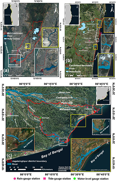
Figure 1. Description of case-studies: (a) Mithi river catchment in Mumbai (b) Greater Chennai Corporation (GCC) in Chennai, and (c) Jagatsinghpur district in Odisha. The inset maps in each figure depict (i) a zoomed view of the shape of the coastal bathymetry that acts as an inlet for intrusion of the tidal waves, and (ii) a part of the river reach length in the area marked by a dense built-up area and huge urban settlements along the river course. The location of rain-gauge, tide-gauge and water level gauging stations are marked in pink circles, pink squares, and green circles, respectively.
Download figure:
Standard image High-resolution imageApart from this, severe storm-tide and surge impacts along the coastline Ranger et al (2011) during the monsoon months exacerbate flood risk in the coastal zones. The Jagatsinghpur region in Odisha is identified as a severe flood-prone region (Ghosh et al 2019, Swain et al 2019, Mohanty et al 2020) as it faces severe floods recurrently during monsoon. This region, in the shape of a trigon, is surrounded by Rivers Mahanadi and Devi on two sides and the Bay of Bengal on the other side. The heavy streamflow from these rivers inundates the floodplains, while tide along with surge during post-monsoon cyclones affects the coastal villages. The GCC region is severely prone to pluvial flooding. The heavy rainfalls during the North East Monsoon (October to December), aging drainage systems and low carrying capacity of the rivers have aggravated the flood risk in recent decades leading to six major floods between 1943 and 2015.
3. Methods
3.1. Data collection
The long-term hourly rainfall information (period: 1970–2011) is collected from India Meteorological Department (Pune, India) operated monitoring stations located at Santacruz in Mithi catchment, Paradeep, Bhubaneswar, and Puri in Jagatsinghpur, and Meenambakkam and Nungabakkam in GCC region. The hourly astronomical (period: 1900–2100) and minute-wise observed storm-tide information (period: 2011–2015) are collected from Indian National Centre for Ocean Information Services (Hyderabad, India). The topographic data in the form of bare earth LiDAR DEMs and other geographical information such as river geometry, land-use land-cover, built-up area, and waterbodies corresponding to the most comprehensive data and comprising of the maximum available length i.e. 2011, are obtained from National Remote Sensing Centre (Hyderabad, India).
3.2. Hydrodynamic flood simulations with design rainfall and storm-tide
The design rainfall time-series ( ) is computed by employing a novel regionalization technique introduced by Mohanty et al 2018). Here, the rainfall information from the monitoring stations is utilized to form a
  by employing the Depth-Duration-Frequency information and design temporal pattern in a non-linear optimization framework. For the stations, a comprehensive multivariate frequency analysis composing of marginal depth-frequency and marginal-duration frequency is performed using various parametric and non-parametric distributions. More details on the list of distributions/models are provided in Sherly et al (2015) and Mohanty et al (2018). The marginals from these distributions are used to derive the conditional probability using copula functions. The joint return period is derived from the quantile values represented by the reciprocal of exceedance probability as described in the supplementary section (Pseudo Code S1). An elaborate description of this approach is provided in the supplementary section (Text S2: figure S1 is available online at (stacks.iop.org/ERL/15/064029/mmedia)). On the other hand, the design storm-tide time-series (
 ) is derived by considering astronomical tide and surge (non-tidal residual) elevation modeled with a family of parametric and non-parametric distributions. The quantile values represented by the reciprocal of exceedance probabilities of astronomical tide and surge are used to derive the corresponding design elevations for a particular return period, as described in the supplementary section (Pseudo Code S2). The sum of design astronomical-tide and design surge elevations is considered as design storm-tide elevation. The temporal pattern, obtained by standardizing the observed time series, is multiplied with the design storm-tide elevation to yield the design storm-tide time series. A detailed description of the computation of
  is provided in the supplementary section (Text S3: figure S2).
The flood model simulations are performed by a 1D-2D coupled MIKE FLOOD (MIKE 11 + MIKE 21 FM HD) model (Löwe et al 2017, Jamali et al 2018, DHI 2019). MIKE FLOOD has been preferred in several past studies (Wright et al 2008, Jamali et al 2018, 2019, Abebe et al 2019, Mohanty et al 2020) owing to numerous advantages and unique features over other flood models such as inclusion of a comprehensive hydraulic structures package, GIS integration, consideration of flooding, wetting and drying depths, seamless conversion of high resolution gridded bathymetry to unstructured triangulated mesh for computational simplicity, inland flooding solver for replicating flood wave propagation in steep gradients, and parallel and GPU computing for faster numerical simulations. More details on its scientific background are provided in the supplementary information (Text S4: Sub-section 1, figures S3 to S6). A key highlight of the MIKE FLOOD is the efficiency with which it can account for the interaction between the downstream channel flow and inflowing storm-tide in coastal regions. More details on this interaction, along with the mathematical equations and key assumptions, are provided in the supplementary information (Text S4). The entire landscape (including built-up area) was processed into a non-orthogonal unstructured triangular mesh in a 2D environment, while the river channel bathymetry was modeled in a 1D environment (Text S4: Sub-section 2, figures S7). Both of these interfaces were interlinked to each other in MIKE FLOOD by establishing lateral linkages for each case-study (figure S8). Other flood influencing basin characteristics such as river channel geometry (channel width and depth), overland floodplain slope, and floodplain resistance (land-use and land-cover) are also considered within the flood model. A detailed specification of the various inputs, considered for each case-study is provided in the supplementary information (Text S4: table S2).
A set of validation experiments is carried out to test the performance of the flood model set-up of each case-study under data-scarce situations. For Mithi catchment, a severe flood event of July 2013 is simulated and compared with the observed flood inundation hot-spots. The flood inundation map is able to capture the flood zones, especially the chronic flood inundation locations. Due to the unavailability of any flood maps in Jagatsinghpur district, a 1D water level calibration (September 2011) and validation (August 2004) are performed. The simulated water levels are compared with the observed water levels through four performance indices. The peak water levels are captured accurately, proving the reliability of the model-setup. For the GCC region, the December 2015 flood event is validated by comparing with 407 locations of observed floodwater depths. A high degree of accuracy is achieved during the comparison. After validation, the  and
and  time-series in the form of time-varying flow conditions are provided as inputs to the model. Two sets of simulations are designed: (i) Pluvial driven: 24 h
  for 2, 5, 10, 20, 50, 100, 200, 500 and 1000 yr return period with a constant 2 yr return period
  and (ii) Storm-tide driven: 24 h
 for 2, 5, 10, 20, 50, 100, 200, 500 and 1000 yr return period with a constant 2 yr return period
  . Although infinite combinations of design rainfall and design storm-tide can be constructed, the above proposed simulation schemes (i & ii) are the only means to portray the marginal/individual impacts of the flood-drivers. The flood hazard is quantified based on the tuple of floodwater depth and velocity ['(d,f)'], i.e. the product of depth 'd' and velocity of flood flow 'f', which captures the momentum of floodwater. The hazard is discretized into five classes based on the degree of severity to humans and economic livelihood, as proposed by Mani et al 2014) (table S4). The five classes are: 'very-low' [0 m2s−1 <'(d,f)' ≤ 0.3 m2s−1], 'low' [0.3 m2s−1 <'(d,f)' ≤ 0.7 m2s−1], 'moderate' [0.7 m2s−1 <'(d,f)' ≤ 1.2 m2s−1], 'high' [1.2 m2s−1 <'(d,f)' ≤ 1.6 m2s−1] and 'very-high' ['(d,f)' >1.6 m2s−1] (table S3). We define TRFQ as the ratio of flood inundation extent (FIE) simulated with
  to
to  (equation (1)). It is expressed as

We define two variants of TRFQ, namely TRFQa, which considers all the five flood hazard classes, and TRFQb, which considers only the high and very-high flood hazard classes in their expressions. The contrasting behavior of these TRFQ variants with various sets of pluvial and storm-tide driven simulations is explored for each case-study. However, since very-low, low and moderate flood hazard spots appear more frequently across a region during a flood event unlike the other classes, the consideration of all the flood hazard classes are more likely to skew the TRFQ values. Most importantly, as high and very-high flood hazard classes imply a higher liklihood of damage/loss, be it human, structural, and economic (Middelmann-Fernandes 2010, Jamali et al 2018), TRFQb is identified as a more appropriate measure. Based on the TRFQb values, we classify the region as storm-tide dominated if TRFQb > 1. When TRFQb < 1, it refers to pluvial dominated. Later, we investigate if there exists any relation between TRFQb and size of catchment. To ensure the flexibility of TRFQb on its application to other coastal regions, where different hazard classes might exist, we perform similar experiments and compare the dynamics with two widely used other flood hazard classifications.
4. Results and discussion
4.1. Regionalized design rainfall ( ) and storm-tide () scenarios


The  and
and  time-series for the three case-studies are formulated (figure S12). We notice a larger cumulative rainfall depth for all return periods with Mithi (Mumbai), followed by Jagatsinghpur (Orissa) and the GCC (Chennai) region. For instance, with a 100-yr rainfall event, Mithi experiences 541 mm of rainfall, while the latter two regions could accumulate 403 and 359 mm of rainfall. Similar results are noticed in the peak rainfall values as well. The peak rainfall in Mithi and Jagatsinghpur appears at similar and shorter time instances, while in the GCC region, it is slightly delayed. This variation is due to different temporal patterns in these case-studies, which distribute the cumulative rainfall depth at different periods. The harmonic analysis of astronomical tide provides us with 37 tidal constituents, among which the principal diurnal and semidiurnal constituents are tabulated in table S1. These values comply closely with those reported earlier by Unnikrishnan (1999) and Sindhu and Unnikrishnan (2013).
4.2. Flood hazard with marginal rainfall and storm-tide
The performance of the flood model for all three case-studies is validated with past flood events. (Text S4; Sub-section: 3). For Mithi catchment, the validation is performed for a 2-day flood event of 23rd and 24th July 2013. We observe a good agreement between the simulated flood areas and the observed inundated regions, especially the high flood-depths are captured properly (figure S9). For Jagatsinghpur district, a 1D water level calibration and validation are performed at two stream-gauge stations located at Naraj and Alipingal with the help of four performance indices. The performance indices are Root Mean Square Error (RMSE), Index of agreement (d), Deviation in peak (Dp), and Percentage deviation in peak (% Dp). The model performs well during calibration and validation, as identified from the performance indices (figure S10 and table S3). The RMSE values were found to be very low [0.24 m and 0.23 m for Naraj and Alipingal in 2011; and 0.26 and 0.24 for Naraj and Alipingal in 2004, respectively] in the two locations during the calibration and validation experiments. The d values closer to unity [0.99 and 0.94 for Naraj and Alipingal in 2011; and 0.99 and 0.98 for Naraj and Alipingal in 2004, respectively] imply an excellent match of the simulated water levels with the observed data. Furthermore, the low values of Dp [0.07 m and − 0.09 m for Naraj in 2011 and 2004; and −0.10 m and −0.17 m for Alipingal in 2011 and 2004] and % Dp [0.25 and −0.83 for Naraj in 2011 and 2004; and −0.82 and −0.78 for Alipingal in 2011 and 2004] indicate that the simulated water level is nearly same as the observed peak water levels of the flood event. For the GCC region, the validation is conducted for a severe flood event that occurred between 1st and 3rd December 2015. Overall, the simulated flood depths match very closely to the observed flood values, except at a few locations over the floodplains of River Adyar. Nearly 60% of the values fall within the range of ±0.5 m, indicating a reasonable degree of accuracy in capturing the observed flood inundation for a complex river network (figure S11).
The flood hazard maps derived with  and
and  for Mithi catchment are illustrated in figure 2. We notice a progressive increase of FIE with the escalation of both
  and
and  . However, a comparatively larger FIE is observed with
  , which is expected as it covers the entire region, unlike
  whose impact is limited up to a few kilometers from the coastal reaches. With a 200 yr
  , we notice a 58% increase in the FIE compared to a 5 yr rainfall event. Similar observations are seen with
  (65% increase). In the case of storm-tide driven flooding, we notice the emergence of inundation along the southern coast. As we focus on the hazard, we find an increase in 'high' and 'very-high areas with an increase in both
  and
and  elevations but with a subsequent decline in 'very-low' hazard areas. Interestingly, storm-tide dominates rainfall when we quantify the percentage of the area under the aforementioned classes of flood hazard. This observation is dangerous from the viewpoint of human fatalities and damages, as a higher flood hazard is likely to cause more chaos than lower flood hazard. Even with a 200 yr event, as high as 56.15% of the area experiences 'high' and 'very-high' hazard with storm-tide, compared to 39.58% with rainfall. One can easily spot the devastating impact of storm-tide (identified by red and orange), reaching even up to a distance of 7 km from the coastal open boundary. This observation leads to numerous implications for a heavily urbanized city such as Mumbai. The fact that storm-tide impact is prominent to such long distances shall affect the functioning of the urban drainage network. The backflow of seawater blocks the drainage mechanism, thus making it nearly impotent for an efficient flow (Hallegatte et al 2010), which was only one of the major highlights of the devastating July 2005 flood event (944 mm of rainfall in 24 h and 4.48 m of tide). Along with that, the overtopping of sea water in the upstream areas is a menace to the unaccounted slum population (Chatterjee 2010).

Figure 2. Flood hazard maps for Mithi catchment in Mumbai based on '(d, f)' for rainfall driven: (a)  of 5 yr,
  of 2 yr; (b)
  of 50 yr,
  of 2 yr (c)
  of 100 yr,
  of 2 yr; and (d)
  of 200 yr,
  of 2 yr; and storm-tide driven: (e)
  of 5 yr, DR of 2 yr; (f)
  of 50 yr, DR of 2 yr (g)
  of 100 yr, DR of 2 yr; and (h)
  of 200 yr,
  of 2 yr scenarios; the inset maps in each hazard map depicts the FIE (km2). We notice larger FIE and percentage of areas under 'high' and 'very-high' flood hazard with storm-tide driven flooding.
Download figure:
Standard image High-resolution imageWith Jagatsinghpur (figure 3), we notice a massive increase in FIE with the progression of rainfall and storm-tide elevations. When we compare the FIE for a 200 yr  and
and  to the corresponding 5 yr counterpart, we find an increase of as high as 108% and 133%, respectively. With high rainfall depths, several areas in the central region are inundated, which were otherwise facing lower hazard at lesser rainfall depths. The flatness of the terrain in this region is not conducive for easy drainage of floodwater to the Bay of Bengal, consequently progressing the flooding extent and hazard with time. This is why the 'high' and 'very-high' hazard spots continue to increase at higher rainfall elevations. Interestingly, the storm-tide impact is prominent even at lesser design elevations due to the presence of vast intertidal areas and complex network of small streams as they continue to inundate larger areas in the coastal stretches with 'high' and 'very-high' hazard. We find that the areas under 'high' and 'very-high' flood hazard increases steadily (32.01%, 33.17%, 34.47%, and 35.58% with 5-, 50-, 100-, and 200 yr
  , respectively), more or less similar to rainfall-driven flooding (48.78%, 53.21%, 55.52%, and 58.58% with 5-, 50-, 100-, and 200 yr
  , respectively).
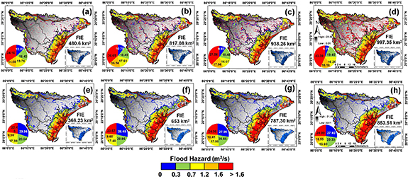
Figure 3. Flood hazard maps for Jagatsinghpur region in Odisha based on '(d, f)' for rainfall driven: (a)  of 5 yr,
  of 2 yr; (b)
  of 50 yr,
  of 2 yr (c)
  of 100 yr,
  of 2 yr; and (d)
  of 200 yr,
  of 2 yr; and storm-tide driven: (e)
  of 5 yr, DR of 2 yr; (f)
  of 50 yr, DR of 2 yr (g)
  of 100 yr, DR of 2 yr; and (h)
  of 200 yr,
  of 2 yr scenarios; the inset maps in each hazard map depicts the FIE (km2). We find a larger contribution of
  to 'high' and 'very-high' flood hazard ['(d, f)'> 1.2 m2s−1] than the corresponding
  scenarios.
Download figure:
Standard image High-resolution imageThe flood maps for Chennai are illustrated in figure 4. Similar to Jagatsinghpur and Mithi, higher rainfall and storm-tide events contribute to an increase in FIE than observed with less extreme events. The increment in FIE reaches 107% and 140%, respectively, vis-à-vis a 200 yr and 5 yr  or
or  .
.

Figure 4. Flood hazard maps for GCC area in Chennai based on '(d, f)' for rainfall driven: (a)  of 5 yr,
  of 2 yr; (b)
  of 50 yr,
  of 2 yr (c)
  of 100 yr,
  of 2 yr; and (d)
  of 200 yr,
  of 2 yr; and storm-tide driven: (e)
  of 5 yr, DR of 2 yr; (f)
  of 50 yr, DR of 2 yr (g)
  of 100 yr, DR of 2 yr; and (h)
  of 200 yr,
  of 2 yr scenarios; the inset maps in each hazard map depicts the FIE (km2). The percentage of areas falling under 'high' and 'very-high' ['(d, f)' > 1.2 m2 s−1] flood hazard is found nearly same in both the scenarios with slightly higher contribution from rainfall.
Download figure:
Standard image High-resolution imageThe contribution of rainfall proliferates, especially in the northern and central regions, while the impact of storm-tide is confined to the eastern coastal region, with a majority of them characterized by 'low' hazard. With the rainfall-driven flooding, only a large patch in the southern portion exhibits a 'high' flood hazard, which intensifies with larger rainfall depth. The severe storm-tide impact is almost imperceptible until a 100-yr event, after which the 'high' and 'very-high' hazard areas (10.34%) start appearing; most of these hazard areas confined to the coastal stretches near Adyar, Cooum and Kosasthalyar rivers (northern part). The tidal impact is mostly attenuated by the Buckingham Canal running parallel to the coastline. This finding corroborates that the storm-tide does not largely amplify the severity of flood hazard unless it is a rare extreme event.
4.3. Tide-Rainfall Flood Quotient
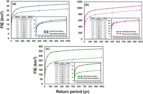
The TRFQa and TRFQb for each region are illustrated in figure 5. In each case, we discover a monotonic progression in the TRFQ values with an increase in the return period. In Mithi (figure 5(a)), the inundation extent with  exceeds that caused by
  as reflected by TRFQa values (TRFQa < 1). Interestingly, we witness an altogether different behavior while considering 'high' and 'very-high' hazard classes, explained by TRFQb. Here,
  dominates the
  contribution to flood hazard. This observation is prominent even at low return periods. With a further increase in storm-tide elevation, TRFQb increases, signifying a larger contribution to increasing proportions of the area under 'high' and 'very-high' hazard classes. This observation reveals the contrasting features of TRFQ values by the introduction of skew in TRFQa with consideration of all flood hazard classes. In Jagatsinghpur (figure 5(b)), both TRFQa and TRFQb were <1 for all return periods. While considering 'high' and 'very-high' hazard, both the flood drivers contributed nearly equal, but the impact of
  is slightly suppressed. This finding is conclusive from the TRFQb values that increase from 0.91 with a 2 yr event and reaches up to 0.95 with a 1000 yr event. In GCC region ((figure 5(c))
  has a larger impact on inundated areas falling under 'high' and 'very-high' hazard, as a result of which TRFQa & TRFQb are <1 even at larger return periods.
Figure 5. TRFQ values for (a) Mithi catchment (b) Jagatsinghpur district and (c) GCC for various scenarios of rainfall and storm-tide. The larger graph exemplifies the progression of FIE by considering all classes of flood hazard (very-low to very-high) in rainfall and storm-tide driven simulations, while the inset graph illustrates for a combination of high and very-high hazard. The inset table lists the values of TRFQ for all ranges of flood hazard (TRFQa) and combination of high and very high flood hazard (TRFQb). From the TRFQb values, we conclude that Mithi catchment is storm-tide dominated, while Jagatsinghpur and GCC region are pluvial dominated.
Download figure:
Standard image High-resolution image
4.2.1. Sensitivity of TRFQ (TRFQb)
This section reports the sensitivity of TRFQb with flood hazard classification and the size of the catchment. For the former, we select the widely used Australian and U.K flood hazard classifications (Text S5: sub-section 1 and table S5) and compare the set of TRFQb values with ours (table S6). We do not find any significant deviations in TRFQb values, which confirm that irrespective of the flood hazard classification adopted, the characterization of the catchment as either 'storm-tide dominated' or 'pluvial dominated' remains unaltered. This observation affirms the flexibility of TRFQb for its application to regions where different hazard classifications might be adopted. To advance our understanding of the influence of the size of the catchment on TRFQb, we perform a sub-catchment level TRFQb analysis for the GCC region (Text S5: sub-section 2). The sub-catchment analysis is performed in Arc GIS 10.6, giving rise to four sub-catchments of varying geographical sizes (figure S13). Based on the TRFQb values, we find that all the sub-catchments are pluvial dominated (TRFQb < 1) [More details in figures S14 and S15]. Earlier, a similar behavior was noticed with the GCC region as well (figure 5(c)). Although the TRFQb values are observed to be nearly same in the sub-catchments, Kosasthalaiyar sub-catchment has the highest value, followed by Kovalam, Adyar and Cooum sub-catchments. Interestingly, even though Kosasthalaiyar has the largest geographical area among the four sub-catchments, the storm-tide slightly dominates the pluvial impact, leading to the largest TRFQb value. This observation provides important evidence that larger catchment size may not necessarily contribute to lesser TRFQb value as anticipated. The channel dimensions (Czech et al 2016, Hajdukiewicz et al 2016, Wyżga et al 2016) may influence the propagation of floodwaters contributed from storm-tide and rainfall in the coastal stretches, and hence the TRFQb values. Basin characteristics such as slope (Kazakis et al 2015, Kourgialas and Karatzas 2017), drainage density (Zaharia et al 2017, Liu et al 2019), flow direction (Wang et al 2015) and upslope contributing area (Samela et al 2017, da Costa et al 2019) may also play a significant role in the flooding pattern observed in the case-studies. A significant interaction between the rainfall-runoff and storm-tide occurs within the channel. The interaction results into a complicated pattern giving rise to over-tides and compound tides (due to alterations in principal diurnal and semidiurnal tidal constituents), and back-water effect (due to reduction in the velocity of streamflow draining into the sea). The extent and velocity of overflowing floodwater across the river channels onto the floodplains are decided by the resultant discharge modelled within the MIKE FLOOD model.
5. Conclusion
The present study explores characteristics of coastal catchments by developing a new metric, Tide-Rainfall Flood Quotient (TRFQ) which classifies them into 'storm-tide dominated' and 'pluvial dominated' flood-prone regions. Although the compound impacts of flood drivers have been studied before, we realize an appropriate knowledge on the susceptibility of a coastal region to the marginal/individual impacts of rainfall and storm-tide is valuable information, which would provide long-term solutions for landscape and floodplain planning. It would provide long-term solutions to the disaster management experts and water professionals in low and medium-income nations for rationalizing the various flood control options within the flood risk management framework. The proposed TRFQ metric is essentially probabilistic in nature as the return periods of design rainfall and design storm-tide are derived by considering exceedance probabilities (a reciprocal of return period) in their estimation framework. We find that TRFQ derived flood maps depict the propensity of tidal/pluvial flooding in coastal regions and thus possess immense potential to be viewed as a cartographic deliverable. Inarguably, TRFQ adds great value by bringing a new dimension to the widely practiced flood-risk maps. In this letter, to demonstrate the concept of TRFQ, we selected three geographically diverse flood-prone coastal regions in India. The flood hazard information was derived from both inundation and wave velocity obtained from a comprehensive 1D-2D MIKE FLOOD model considering a high-resolution LiDAR DEM. The precision of model set-up for each case-study was tested by validating with past floo'd events. A high degree of accuracy is achieved between the simulated and observed flood inundation statistics, proving the superior performance of the model for each case-study. Later, a set of specific combinations of storm-tide and pluvial driven simulations were proposed to quantify the marginal/individual impacts of
  and
and  as hydrologic and hydrodynamic inputs, respectively. Based on our analyses, we find that Mithi catchment (Mumbai) is 'storm-tide dominated', while Jagatsinghpur (Odisha) and GCC region (Chennai) are 'pluvial dominated'.
Given that extreme events of rainfall and storm-tide are probable over coastal regions, most often in tandem, every region has an inherent response to either of these drivers. TRFQ will facilitate planning and rationalization of long-term flood-management options over coastal catchments through characterization of pluvial/tidal flood dominance. For storm-tide dominated regions, severe flood hazard can be alleviated by building coastal defense structures such as closure dams, tide breakers, and storm-surge barriers at appropriate locations. The tide and surge forecasting systems in these regions should be equipped with state-of-the-art ocean circulation models such as Advanced Circulation (ADCIRC) and wind wave models namely SWAN, WAM, and WAVEWATCH III. Further, to keep an account of the progression of tide in the urban drainage, depth measuring sensors can be installed at several flood affected hotspots. Although simultaneous occurrence of hazard due to rainfall and storm-tide are likely, our maiden attempt in quantifying the inherent response of any catchment to the individual impacts of these drivers reveals the possibility of designing a new cartographic product that, if consulted during planning phases, will deliver valuable information to flood control authorities. On the other hand, for pluvial dominated regions, structural measures such as rainwater storage structures, lakes, and detention basins should be prioritized in the flood management plans. In such regions, the existing flood forecasting systems should be equipped with physics-based models such as Weather Research and Forecasting (WRF) for improved rainfall forecasting. For instance, in urban centers like Mumbai where pattern-less spatio-temporal variations of rainfall exist (Singh et al 2017), short-term forecasts derived from numerical weather prediction (NWP) models may provide valuable information for real-time flood forecasting. In addition, Doppler Weather Radar (DWR) designed to provide improved convective rainfall forecasts can be identified as a potential source of improved boundary conditions to NWP. The resilience of the urban drainage infrastructure needs to be revamped, in order to tackle complexities associated with the drainage network and possible serious breakdowns during heavy flood flows.
The alterations in TRFQ through characterization of flood hazard is an intricate process and depends on the feedback between flood drivers (rainfall and storm-tide elevations) and basin characteristics in a hydrodynamic-cum-geomorphic environment. In the present study, we demonstrate the contrasting behavior of TRFQ to flood hazard classes through two variants, namely TRFQa (considering all flood hazard classes) and TRFQb (considering only high and very-high flood hazard classes). However, as consideration of all flood hazard classes is amenable to introducing skew in the TRFQ values, we consider TRFQb as a more appropriate measure. The flexibility of TRFQb for its application to other coastal regions with different flood hazard classifications is also investigated. We notice that irrespective of any hazard classification, the dynamics of TRFQb remains unaffected. It is possible that the cut-offs of hazard classes and hazard classification for other regions might differ. On such occasions, the selection of flood hazard classes rests on the government, policy makers and disaster management bodies. A standard protocol of 'which' and 'how' flood hazard classes can be considered in the identification of TRFQ should be outlined.
The derivation of TRFQ is a challenging task with the rigorous involvement of hydrodynamics in the process of flood inundation mapping. Thanks to rapid advances in computing science in recent decades that have contributed to an exponential improvement in the computational capability and geometric flexibility of the flood models. A new era is not far when the constraints faced in terms of data handling and computational complexities will be alleviated. The characterization of TRFQ is a one-time task and is worth exemplifying for nations like India that has a long geographical coastline of nearly 7500 km. TRFQ, as a cartographic product, possesses crucial qualitative and quantitative information on understanding the influence of flood drivers on flood damage. In an era where all nations are trying their best to face climate change-related consequences, such as increase in rainfall extremes and sea-level rise, the information on TRFQ holds prime importance within the framework of coastal flood management for long-term solutions.
TRFQ, surprisingly not having been conceptualized well in the past, holds promise for contributive value to flood risk management in coastal cities, particularly for low and medium-income nations where huge investment in flood control options is a costly affair. For long-term landscape and urban planning, we propose this metric be necessarily derived to control the high cost associated with flood management through optimal selection of structural and non-structural measures. A set of global screening studies (Nicholls et al 2008, Hanson et al 2011, Hallegatte et al 2013) has ranked 136 coastal port cities that will be largely impacted by climate extremes, land subsidence, and growing populations and assets in the upcoming decades. We emphasize that TRFQ assessment should be initiated on priority in these cities followed by other vulnerable regions. We need to acknowledge the looming catastrophic flood events ahead and acquire behavioral knowledge of coastal catchments to alleviate flood damage and losses.
Acknowledgments
The work presented here is jointly supported by the Office of the Principal Scientific Advisor, Govt. of India (Project No. 16DST022), Ministry of Earth Sciences, Govt. of India (Project No. 14MES003), and ISRO-IIT(B)-Space Technology Cell (Project No. 14ISROC009 and RD/0119-ISROC00-001). The hourly observed station level rainfall data used for design rainfall analysis for all three case-studies are procured from Data Supply Portal of India Meteorological Department, Pune available at http://dsp.imdpune.gov.in/. The authors acknowledge the Special Relief Commissioner, Govt. of Odisha for providing the observed taluka-level rainfall data for Jagatsinghpur district at http://srcodisha.nic.in/rain_fall.php. The station-level observed streamflow and water-level data for stations at Naraj and Alipingal for validating past flood events in Jagatsinghpur district is available at http://indiawris.gov.in/wris/. The observed and simulated tide elevation data for design tide analysis for all three case-studies is procured from Indian National Centre for Ocean Information Services (https://incois.gov.in/portal/datainfo/drform.jsp). Land use-Land Cover data for all three case-studies are obtained by National Remote Sensing Centre, Hyderabad (https://www.nrsc.gov.in/) and are available at https://bhuvan-app1.nrsc.gov.in/thematic/thematic/index.php. The built-up layer for all three case-studies is obtained from open street maps at https://www.openstreetmap.org.
Data availability statement
The data that support the findings of this study are available from the corresponding author upon reasonable request.