

Abstract
Global models of biophysical suitability for oil palm consistently rank Brazil as having the greatest potential for expansion, with estimates as high as 238 Mha of suitable lands. In 2010, Brazil launched the Sustainable Palm Oil Production Program (SPOPP) to incentivize oil palm development without deforestation on as much as 30 Mha. Here we examine oil palm expansion before and after the SPOPP's launch. In Pará, the major oil palm producing state in Brazil, we analyze the extent and change in oil palm cultivation from 2006−2014 using satellite imagery, ground-truthed verification, site-based interviews, and rural environmental (land) registration data. Between 2006−2014, oil palm area (≥9 ha) expanded >200% to ~219 000 ha. Of the ~148 000 ha of oil palm developed, ~91% converted pasturelands while ~8% replaced natural vegetation, including intact and secondary forests. Although >80% of all oil palm parcels rest <0.5 km from intact forests, direct conversion of intact forests declined from ~4% pre-SPOPP (2006−2010) to <1% post-SPOPP (2010−2014).
Despite low and declining deforestation rates associated with oil palm expansion in Pará, our results also show a low area of oil palm development overall compared with reported land suitability. To explore potential contributing factors, we conducted semi-structured interviews with researchers, company representatives, and government officials involved in the sector to characterize the perceived factors influencing oil palm development and the role of agro-ecological suitability mapping among them. Interviews indicated that: (1) individual effects of suitability mapping efforts to encourage oil palm expansion on cleared areas, i.e. without deforestation, cannot be disentangled from pre-existing public and private deforestation reduction initiatives; and, (2) socio-economic constraints, e.g. high relative production costs and limited familiarity with this crop, appear to partially explain the major discrepancy between estimated potential suitable areas with realized oil palm development.
Export citation and abstract BibTeX RIS
1. Introduction
Agricultural expansion has been a major source of deforestation across tropical regions (Geist and Lambin 2002, Rudel et al 2009, Gibbs et al 2010, Henders et al 2015). Cultivated area for oil palm, in particular, expanded four-fold between the 1960s and the mid-2000s, as the crop transformed tropical landscapes, especially in Indonesia and Malaysia (Kongsager and Reenberg 2012, Carlson et al 2012b, Gunarso et al 2013, Henders et al 2015). Despite potential for oil palm development without forest conversion, historically oil palm development has involved clearing of primary or secondary forests. Between 13%−90% of studied oil palm expansion was observed to have cleared forested lands across several tropical countries including Indonesia, Malaysia, Colombia, and Peru (Gutierrez-Velez et al 2011, Wicke et al 2011, Miettinen et al 2012, Carlson et al 2012b, 2012a, Gunarso et al 2013, Castiblanco et al 2013, Margono et al 2014, Vijay et al 2016, Furumo and Aide 2017).
Among potential oil palm producing countries, global biophysical models suggest Brazil has the largest remaining potential land area suitable for oil palm production, with estimates ranging from 30−42 Mha without forests (Ramalho Filho et al 2010, Pirker et al 2016) to 228 Mha including forests (Stickler et al 2007). From 2004−2014, deforestation rates in the Brazilian Amazon declined over 70% (Nepstad et al 2014), with notable progress on decoupling Amazonian forest conversion and soy production (Macedo et al 2012, Richards et al 2014) and advances in corporate agreements for reducing deforestation in the cattle supply chain (Gibbs et al 2016). Given historical links between deforestation and oil palm development worldwide, questions remain whether Brazil would be successful in decoupling its oil palm growth from deforestation and thus promote oil palm production without imperiling Brazil's progress in reducing Amazonian deforestation.
In response to the social and environmental challenges of oil palm growth observed elsewhere, in 2010, the Brazilian Agricultural Research Agency (EMBRAPA) released a biophysical suitability map for oil palm cultivation in Brazil, entitled the 'Agro-ecological Zoning of Oil Palm Cultivation for Deforested Areas in the Legal Amazon,' henceforth, ZAE. The mapping process first excluded legally protected parks, intact forest areas, and indigenous reserves from consideration, then evaluated biophysical characteristics such as soil and precipitation suitability (SI section 1) to conclude that Brazil contains the world's largest potential of non-forested suitable lands to cultivate oil palm: 31.2 Mha of suitable non-forested lands, or nearly two-fold all oil palm area planted by 2010 worldwide (Pirker et al 2016).

Figure 1. Extent of oil palm planted by 2014, by 2006 land use. Conversion of intact forest and secondary vegetation areas was limited, but often near existing oil palm development. Base map sources—roads (SETRAN 2009), mills (CIFOR 2015), urban areas (IBGE 2015), water bodies (MMA), forest (INPE).
Download figure:
Standard image High-resolution imageWhile led by the soils division of EMBRAPA's northern region and financed by the Federal Ministry of Science and Technology, the ZAE was a collaborative effort among many other public and private actors. This high degree of intergovernmental coordination would be expected to strengthen the ZAE's potential effects. EMBRAPA has affirmed that it is illegal to breach the ZAE, such that palm producers would likely be concerned about avoiding deforestation. Moreover, oil palm projects within ZAE's restricted areas would be prevented from obtaining environmental licenses and public credit. More broadly, the ZAE formed the basis of Brazil's 2010 Sustainable Palm Oil Production Program (SPOPP). The objectives of the SPOPP were both to support palm cultivation as a means for inclusive economic development and to diversify fuel sources used to fulfill expectations on increasing national biodiesel requirements. The National Biodiesel Use Policy (PNPB, Law n° 11.097/2005) mandated a 2% biodiesel-fossil fuel blend by 2008, 5% by 2010, and 7% by 2014. In 2016, the blend mandate was further increased to 10% by 2019 (ANP, 2016). With the goals of PNPB in the background, the SPOPP intended to facilitate ~R$60 m (~$34 m, 2010 USD) towards crop research, offer funding for technical assistance and three special low-interest financing lines, and create a Chamber of Palm Oil Production that would include federal government representatives, producers, and consumers to identify opportunities to improve the palm oil supply chain (INCRA 2010, Bertone 2011).
When the SPOPP was launched in 2010, the State of Pará represented >80% of Brazil's reported oil palm production, with official estimates of ~60 000–108 000 ha under oil palm cultivation (FNP 2010, Homma 2016, IBGE 2017). By supporting the ZAE within the SPOPP, the federal government sought to provide a framework for the crop to expand on areas designated as previously deforested lands. The ZAE concluded that oil palm could potentially expand over 300 times the 2010 planted area to >30 Mha without direct forest loss (Ramalho Filho et al 2010). Apart from the ZAE and the sector's efforts for zero-deforestation, some secondary and even intact forest conversion was possible and indeed may have still remained within a property holder's legal right: the Forest Code legally permits 20% of new forest conversion on a given land holding (Brito 2017), and governance of secondary forests, including the determination of what is legally harvestable or not, has proven challenging (Vieira et al 2014).
Our study aims to evaluate whether oil palm expansion conformed with the stated SPOPP objective: to enhance the amount of oil palm production on non-forested lands. More specifically, the three central questions guiding this work are: First, what are the changes in area and distribution of oil palm plantations in Pará from the pre-SPOPP period (2006−2010) to the post-SPOPP period (2010−2014)? Second, did oil palm development in the Brazilian Legal Amazon conform to zero-deforestation goals, i.e. what land use types were converted to oil palm plantations? Third, how did local actors perceive which factors influenced the rate of oil palm development, and what was the role of the ZAE among them?
2. Methods
2.1. Study site
The study region spans ca. 50 000 km2 within the state of Pará (50°W−47°W and 0.5°S−4°S, figure 1), and represents the region where nearly all known commercial oil palm production in the Brazilian Amazon occurs (Villela et al 2014). Generally well drained but low fertility yellow latosols of medium clay content (<30%) dominate (Muller 1980) the flat or gently undulating landscape (50−100 m a.s.l.). Precipitation ranges 2000−2500 mm yr−1, and all months average >60 mm, as required for rain-fed palm oil production (Muller 1980). Mean temperature is 26 °C ± 3 °C throughout the year.
Several agricultural production systems occur across this region. Cattle has dominated the human-modified landscape, especially since the late 1960s with the completion of the Belém-Brasilia (BR 010) highway (Hecht 1985, Uhl et al 1988, Almeida and Uhl 1995, Krummel et al 2008). Other land uses include black pepper, açaí, and tree (e.g. eucalyptus) production; commercial timber extraction; and reforestation activities (Rebello 2012, Homma 2016). Cassava, rice, and beans remain an important source of local smallholder production and consumption (Nahum and Santos 2013). This study area also falls within the Belém Center of Endemism, a highly fragmented and fire-prone region that ranks among the most deforested and ecologically threatened eco-regions of Amazônia (Almeida and Vieira 2010).
2.2. Identification of oil palm areas
Satellite imagery was classified as oil palm using visual inspection techniques, consistent with other regional land use analyses such as the reference land use mapping project for Amazonia, which is called TerraClass (Coutinho et al 2013, INPE 2016), and other well-regarded oil palm classification studies, e.g. Gunarso et al 2013. Oil palm areas (>9 ha) established by 2014 were detected using pan-sharpened (15 m) LANDSAT 8 data and, where available, high resolution imagery featured in Google Earth's gallery (SI, section 2). These areas were then validated through field and site visits, consultation with regional experts, and comparison with information available in the October 2014 rural environmental register (Cadastro Ambiental Rural—CAR). Images from Landsat 5 and 8 were selected for maximum image quality; thus, images generally span June–October, during the region's dry period (SI, section 2.1). Two different band combinations were employed (RBG 7−5−4 and 5−4−3), which provided the interpreters considerable discrimination between oil palm and other land uses for visual interpretation (SI, section 2).
To assess classification performance, an initial site visit (August 2014) was conducted by AS&MC to validate areas previously identified as oil palm from satellite imagery. Then, EB conducted a second validation field assessment (July 2015) to compare preliminary results with two additional secondary data sources, including the CAR environmental land registry and a within-EMBRAPA initiative for mapping oil palm (Venturieri 2012, Rodrigues 2012). The oil palm maps were revised and then discussed with regional land use experts at EMBRAPA and seven oil palm companies who either affirmed area boundaries or identified previously undetected areas. These seven oil palm companies accounted for ~90% of known areas cultivated with oil palm in this region (Brandão and Schoneveld 2015). An additional accuracy assessment was conducted using 300 randomly selected points across the study area (150 in areas classified as oil palm; 150 in areas not classified as oil palm), using the Google Earth annual LANDSAT composite gallery and available high-resolution imagery (SI section 2).
2.3. Historical classification
For areas under oil palm cultivation in 2014, seven mosaicked Landsat 5 scenes from each of 2010, 2008, and 2006 were used to determine the historical land use of the palm areas, supplemented with high-resolution historical imagery available from Google Earth. Areas identified as secondary vegetation appeared visually distinct from the darker-colored, heterogeneous, and roughly-textured regions typically associated with primary intact forest areas (SI section 2.3). To support intact forest identification, we also referred to the full catalog of annual Landsat mosaics available in Google Earth and the PRODES product (INPE 2017) that serves as Brazil's official forest and deforestation record.
The historical classification focused on four land use types: well-maintained pasture, overgrown pasture, secondary vegetation, and primary forest. Due to challenges in consistently distinguishing between pasture classes between years, well-maintained and overgrown pasture areas were then merged into a 'pasture' class. These non-oil palm land uses correspond with a subset of land use categories used in TerraClass, a joint project between the Brazilian Institute for Space Research (INPE) and EMBRAPA wherein all non-primary forest pixels in the legal Amazon were classified into twelve land use classes (Almeida et al 2016). Because we focus on detecting vegetation versus pasture conversion, the TerraClass categories we use provide a suitable reference subset for our analyses.
2.4. Interviews and document analysis
To evaluate the suite of factors and perceptions that may facilitate or hinder oil palm development in Brazil and, specifically, Pará, EB conducted 48 semi-structured interviews with individuals or groups involved in the sector, selected via a mixture of targeted sampling (Watters and Biernacki 1989) and key informant techniques (methodology elaborated in Tremblay 1957, examples of their use in Brazilian Amazon include Arima et al 2005, Simmons et al 2010). Interviewees included managers from seven palm producing companies in the region, a sector association representative (ABRAPALMA), university-affiliated scholars from the Universidade Federal (UF) do Pará, UF do Rio de Janeiro, UF Fluminense, social scientists and agronomists at EMBRAPA, bank managers at Banco da Amazônia knowledgeable or responsible for the disbursement of smallholder loans for oil palm, cooperative managers in a key producing municipality of Tomé-Açu, multiple individuals associated with seven NGOs, and state and national level government officials with expertise either in oil palm, biodiesel, or land use development in Eastern Amazonia. Questions focused on the interviewees' perceptions about the conditions that either facilitated or hindered oil palm development.
3. Results
3.1. Oil palm areas in 2014
AC & MS planned a first verification route that would span the border of the classified oil palm areas. In the 1600 km initial field assessment route, 43 of 367 total oil palm areas were validated and 47 oil palm areas initially unidentified were added. These added sites were either <9 ha or were recently established and thus lacked distinctive road networks that were key for identification in satellite imagery. In addition, three oil palm areas were undetected because of either cloud cover or overgrown roads (Swartos 2015).
Corrections from the second field assessment amounted to changes of ~30 000 ha. Areas removed from the first verification were predominantly planted with coconut and near other oil palm plantations. These coconut areas featured similar repeating rectangular road networks to oil palm areas and presented a similar appearance to oil palm crowns in high resolution imagery. The coconut areas removed were identified through either regional land use experts or rural environmental land registration data (SI, section 2.2).
For evaluating the accuracy of our classification using the 300 points selected via stratified random sampling, we used a conservative threshold for categorizing a point in the 'not palm' land use class: These points exhibited most characteristics of oil palm cultivation, but also contain some atypical features. These points also had insufficient spatial or temporal resolution in the remote sensing imagery, such that we would suggest a verification field visit for definitive confirmation. From this approach, we obtained a 97% producer's accuracy (sensitivity), 98% user's accuracy (specificity), and a 97% overall accuracy rate (SI, section 2.4).
Table 1. Land use types directly converted for oil palm in the four years before and after the SPOPP launch. During these eight years (2006–2014), the area cultivated with oil palm nearly tripled. Pasture served as the dominant source (>90%) of oil palm conversion both before and after the SPOPP's launch in 2010. While the amount of intact forest directly converted for oil palm was nonzero, the amount declined between the two periods. See SI table 7 for full conversion pathways and indirect conversion.
| Land use types sourced for oil palm conversion | Pre-SPOPP 2006−2010 | Post-SPOPP 2010−2014 | Percent change | ||
|---|---|---|---|---|---|
| ha | % | ha | % | % | |
| Pasture | 41 592 | 90.3 | 97 894 | 95.8 | 135 |
| Secondary vegetation | 2254 | 4.9 | 3037 | 3.0 | 35 |
| Intact forest | 1891 | 4.1 | 793 | 0.8 | −58 |
| Masked by clouds | 319 | 0.7 | 445 | 0.4 | 39 |
| Expansion | 46 057 | 100.0 | 102 169 | 100.0 | 122 |
| Oil palm at onset | 70 691 | − | 116 748 | − | − |
| Totals | 116 748 | − | 218 917 | − | − |
3.2. Historical land use
Figure 1 illustrates the full extent of the final area mapped as planted with oil palm by 2014, with its corresponding 2006 land use. Comparing the 2014 dry season planted oil palm area with the 2010 area indicates that 102 169 ha were converted to oil palm during the four years following the 2010 implementation of the SPOPP. This amount of land represents more than twice the oil palm expansion that occurred in 2006−2010 pre-SPOPP period (46 057 ha). Across all years (2006−2014), ~91.2% of oil palm areas were established from converting pastures; ~5.2% from secondary forests; ~2.7% from intact forests; and <1% were masked by cloud cover.
In the post-SPOPP period, direct primary forest conversion comprised <1% (793 ha) of oil palm expansion area compared with ~4% (1891 ha) in the pre-SPOPP period (table 1). In addition, while only 793 ha of 2010−2014 expansion was forested area in 2010, reconstructing the 2006 land types of all areas in palm indicates that ~150% of this figure, or 1291 ha of intact forest, underwent intermediate conversion to pasture or secondary forest by 2010, and then was converted to oil palm. Land use trajectories are illustrated in figure 3 and enumerated in the SI table 7 available at stacks.iop.org/ERL/13/034037/mmedia. As oil palm expansion doubled between these two periods, oil palm increased on both the intensive and extensive margins: 18 municipalities with oil palm in 2006 expanded their cultivated areas while new oil palm areas were developed in nine additional municipalities for the first time (SI, table 3).
Though limited direct conversion occurred in this region, expansion often occurred close to forested areas: 424 parcels (~60% of unique contiguous oil palm areas) have a border within 10 meters of forested areas (SI figure 4). Proximity of a plantation border to forest areas is of particular relevance given one deforestation pattern we detected during this analysis: when some areas planted with oil palm expanded their existing cultivated area via converting adjacent forests. As pasture areas expanded in 60% of municipalities where oil palm was growing (SI table 3), forests also declined a combined ~322 000 ha across the oil-palm growing municipalities. The forest decline in those municipalities exceeded deforestation associated with oil palm >100 fold. Moreover, ~969 579 ha of forested areas in 2015 rest within a a 50 km radius established palm oil mills, i.e. >four-fold the area of detected oil palm development and three orders of magnitude greater than the detected deforestation associated with oil palm expansion in Pará between 2006 and 2014.
3.3. Stakeholder interviews
Overall, interviews confirmed that the suitability mapping/agro-ecological zoning (ZAE) captured many biophysical variables relevant for oil palm production. However, many respondents also indicated the geographical extent of suitable areas delineated by the ZAE and similar models appears too optimistic. The resolution of the input data used to generate the ZAE were not only too coarse in spatial extent (Motta and Brefin 2011), but also did not incorporate key variables that influence the economics of oil palm production and its social context. Here, we provide a qualitative summary of perceptions about the major contributors to the observed gap between modeling estimates and realized development, highlighting distinctive responses generated from representatives across each interviewed sector (table 2). In general, civil society and research groups emphasized social and environmental externalities, and government agents highlighted competing and shifting priorities for limited resources. Companies and private sector representatives reflected on market dynamics and costs of production—factors that are examined quantitatively in a complementary paper (Benami et al in preparation).
Table 2. Perspectives on constraints to oil palm expansion and production in Pará.
| Issue | Company/private sector representatives (n = 28) | Civil society and researchers (n = 14) | Government representatives (n = 6) |
|---|---|---|---|
| Unmapped ecological variables | - Temperature sensitivity induces yield variability- Southern areas in ZAE too dry without irrigation, uneconomic- Areas with excessive precipitation have elevated risk of fatal yellowing disease | - Campinas areas that had been planted in select areas are both environmentally sensitive and do not support oil palm production- Concerns of oil palm-adjacent water quality impairment | Potential effects of climate variability on temperature and water regimes suitable for long term investments in oil palm |
| Confused land tenure, despite regularization efforts | -Overlapping land claims-Limited economically contiguous areas-Slow pace of regularization | Overlapping claims, esp. among quilombola (descendants of former runaway slave communities) and indigenous communities | Permit application backlogs with declining resources for timely processing |
| Labor availability | - Perceived lack of interested, trained applicants- Hybrid, disease-resistant varieties are labor-intensive and expensive | - Difficult working conditions for harvest- Interstate labor migration cautiously viewed | − |
| Smallholder eligibility for, and interest, in long-term loans | Loan eligibility restricted due to indebtedness or missing documents | Among eligible (i.e. non-credit blacklisted) farmers, cautiousness on long-term commitment and repayment requirements | − |
| Market structure | - Biodiesel uneconomic relative to other markets/opportunities- Limited market power in commodity exchange: Delayed payments from some buyers with few alternatives to negotiate, or high transaction costs for multiple small buyers- Reliance on fertilizer imports, tied to forex fluctuations- High production costs often render domestic product uncompetitive with imported substitutes | - Concerns about displacing local food production (cassava/bean price spikes), especially in communities poorly linked to alternative options- Known alternatives, including açaí and pepper, competing for land, labor, and capital− | Changes in administration/government priorities−− |
| Infrastructure (paved roads, shipping, bridges) | - Delayed construction and insufficient mill capacity for all newly planted areas- Over-optimistic projection on river-based transport logistics- High delivery costs for in- and out-puts due to limited paved road network and port management/fees | −−− | Regional port construction, bridge repair, and paving not prioritized for already- overburdened public budgets−− |
| Land acquisition/management constraints | - Restrictions on land acquisition by international companies- Perceived costly requirement to maintain/manage forested areas (Reserva Legal)- Limited investment in R&D | - Comparatively limited history with farmer associations/organizations- Insufficient technical support for smallholders− |
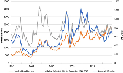
Figure 2. Crude palm oil price trends in BRL and USD: 1997−2016. The international price of oil palm (blue, in nominal USD) fluctuated significantly between 2006 and 2014, though USD-BRL exchange rate changes dampened the fluctuations transmitted to nominal (non-inflation-adjusted) and inflation-adjusted oil palm prices in Brazil. Source: Indexmundi 2017, IBGE 2016, US Federal Reserve 2017.
Download figure:
Standard image High-resolution imageRespondents from all three sectors commented on challenges associated with land tenure, though their emphasis varied by expertise and affiliation. Companies lamented costly delays in identifying and developing lands due to competing claims or lack of sufficient documentation. Individuals interviewed from civil society and research agencies expressed concern that some rural communities and long-term residents were unable to verify their land claims, which could result in either unrealized potential among those wanting to develop land, or leave residents vulnerable to land speculation, especially among those less able to legally defend their claims. Government representatives registered frustration with insufficient resources to quickly process high volumes of land registration and environmental license applications.
Meyfroidt et al (2014) reported that previously cleared lands are favored by developers when commodity crops require access to infrastructure. Several private sector representatives and EMBRAPA reports reinforced this finding, as they noted how infrastructure, including a limited paved road network in the study area, is currently inadequate to support rapid expansion of oil palm (Veiga et al 2005, Rocha and Castro 2012, César et al 2013). Robust transportation is especially critical for oil palm, as high-quality crude palm oil (CPO) production depends on road or river networks to reliably deliver fresh fruit bunches from plantation to mill within 24–48 hours.
Despite a tripling of oil palm area from 2006−2014, these responses provide context on how current oil palm planted area amounts to <1% of the potentially suitable areas delineated in the ZAE. These regional interviews also revealed that low palm oil prices relative to pre-2010 expectations (figure 2), compounded with weak national economic circumstances and political turmoil, contributed to reduced investment and management of not only already-planted lands but also downwardly revised planting and infrastructure development targets in the near-term.
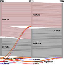
Figure 3. Land use types converted to oil palm from 2006–2014. The sankey diagram depicts land use trajectories from 2006–2014. First, the conversion trajectory of all areas that were in oil palm in 2014 < 9 ha are reconstructed back to their land use types in 2006 and 2010, then presented in figure 2. Sankey diagrams are used to track material flows (Schmidt 2008) including agricultural supply chains (Godar et al 2016), and to depict magnitudes of relationships between inputs as they are transformed. Each line represents a unique trajectory featured in the analysis. Bar height represents area: the vertical bars at left reflect the 2006 land uses of all areas in oil palm in 2014, the middle vertical bar reflect each parcel's land use type at 2010. The solid vertical bar at right represents the total area in oil palm by 2014, i.e. 218 917 ha. Each horizontal line's thickness represents the per parcel area. Diagram created with googlevis package (Gesman and Castillo 2011) in R 4.3 (R Core Team 2017).
Download figure:
Standard image High-resolution image
Importantly, Pará's oil palm development has been dominated by three companies, who together account for >75% of Pará's 2014 area under oil palm. Two of these companies began operating after 2006. The oldest of the three, Agropalma (est. 1982) has been ranked among the most sustainable oil palm producers globally by WWF (2013). The company developed its own zero-deforestation commitment in 2001 (Brito 2014) and became a member company in the Roundtable for Sustainable Palm Oil in RSPO's inaugural year of 2004 (Agropalma Group and RSPO 2016). Agropalma has also served as an active participant in furthering the RSPO standard—for example, by supporting the first smallholders to receive RSPO certification in Latin America (Brito 2015), and certifying 100% of its plantation areas and its five mills (Agropalma Group and RSPO 2016). By contrast, the firm with the largest amount of area planted by 2014, Biopalma (first planting 2007), had a majority share bought by the mining concern Vale in 2011, who intended to fuel a portion of its operations with oil palm-based diesel (Vale 2013). However, changes in leadership, unanticipated logistical difficulties, and weaker macro-economic conditions have slowed their ambitious development plans, and Vale is rumored to be exploring divestment (Brandão and Schoneveld 2015). The third largest participant, Belém Bioenergia (BBB; first planting 2010), is a joint venture between a Portuguese energy company (GALP) and the semi-public corporation Petrobras. Following the corruption investigations that expanded significantly in 2014 and influenced company-wide investment options (Place 2016), in 2016, Petrobras announced divestment from all bioenergy production in its 2017−2022 strategic plan (Petrobras 2016b). BBB had already revised their planting area targets from 60 000 (Belem Bioenergia Brasil 2014) to 42 000 ha and postponed plans for 405tFFB/hour milling capacity (Petrobras 2016a). However, in 2017, company reports indicated they were exploring third-party arrangements to finance mill construction (Petrobras 2017).
Yet, even if all planned mills except BBB's mills were constructed, and without constraints on inter-company trade, mills functioning within their typical operating ranges could support ~271 000 ha, or 25% more than the 2014 planted area (SI section 4.2), assuming annual mature yields of ~19 FFB/ha, i.e. Agropalma's production average (Agropalma 2015). In addition, though some interviewees associated the gap between domestic consumption of crude palm oil (~500 000 MT CPO) against domestic production levels (~400 000 MT) as a rationale to support expansion (SI figures 11 and 12), others reported that the high CPO import volume from Indonesia (∼150 000 MT) and Malaysia, Colombia, and Ecuador (each ~25 000 MT, SI), reflect the difficulties in the present political and physical infrastructure to support a cost-competitive domestic alternative (SI).
Given Agropalma's sustainability commitments and its high share of Brazil's mature palm oil production, Brazil has had one of the highest national proportions of RSPO-certified oil palm production (~48% of 2012 production volume, Potts et al 2014). Two smaller growers (< 10 000 ha planted area each) are also RSPO members (RSPO and ADM 2017, RSPO and Marborges 2017), and Biopalma has taken steps towards obtaining certification (OrbisExceller 2016). Whereas interviewees suggested that Brazilian production is not considered cost-competitive in CPO commodity trade, premiums for certified deforestation-free products have helped offset, though not eliminate, cost disadvantages. Should labor costs increase in other producing countries, as anticipated in Malaysia (Byerlee et al 2017c), the relative cost disadvantage may diminish. However, even if Brazil approached relative cost-parity, increases in CPO cost structure among all oil palm producers could induce substitution towards other goods (for some commercially available examples, Hinrichsen 2016), should the economics of oil-palm alternatives prove more favorable in the long term.
4. Discussion and conclusion
By integrating local records and site visits to supplement satellite imagery classification, this paper characterizes oil palm expansion dynamics in Brazil between 2006−2014 and provides context for the contrast between suitability modeling projections and realized development. Previous studies analyzing land use trajectories of Brazilian oil palm assessed samples that were <40% of our evaluated areas: Vijay et al (2016) evaluates ~50 000 ha and Furumo and Aide (2017) ~80 000 ha, compared with our ~219 000 ha. Furthermore, previous studies also evaluated Brazil's trajectory within the context of pan-Latin American or global land use change, referring to a timeline of the immediate prior land use (Furumo and Aide 2017) or 1989 (Vijay et al 2016). In doing so, they provide a macro-level snapshot of changes across regions and time frames. We build on their work by first increasing the area evaluated in Brazil, and then selecting a historical baseline designed to link changes in land use conversion patterns with local policy initiatives aimed to enhance oil palm production that is decoupled from deforestation.
Overall, both rates and amounts of intact forest clearing directly associated with oil palm declined from the pre-SPOPP (2006−2010) to post-SPOPP period (2010−2014). However, by tracing 2014 areas in oil palm to 2006, we found an additional ~1300 ha of intact forested areas that were converted initially to pasture before oil palm establishment in 2010−2014 (main text figure 3, or SI table 7). Even if direct forest conversion rates declined over time, this intermediate conversion reinforces Vijay et al (2016)'s statement that what qualifies as deforestation-free oil palm may depend on your reference year, and may explain the differences between our results: little 'deforestation-free' oil palm exists the further back the analytical baseline begins.
Although the intact forest conversion documented here contrasts with the SPOPP's no-deforestation objectives, our results indicate that both intact and secondary vegetation were converted at a much lower rate than other tropical regions of oil palm expansion, where 15%−90% of recent expansion occurred by converting secondary forests, agroforests, and intact forests (Gutierrez-Velez et al 2011, Wicke et al 2011, Miettinen et al 2012, Carlson et al 2012b, 2012a, Gunarso et al 2013, Castiblanco et al 2013, Margono et al 2014, Vijay et al 2016, Furumo and Aide 2017). In addition, compared with the four years before the SPOPP, the proportion of both primary and secondary vegetation directly converted to oil palm after 2010 declined.
While our results also show that realized oil palm development falls significantly below the ZAE's lower bound estimates for oil palm potential in Brazil, they also raise critical questions. First, how much of an additional effect did the zoning component of the SPOPP have in incentivizing palm oil production while limiting deforestation? Addressing this question causally requires observing a valid counterfactual, i.e. evaluating outcomes among otherwise comparable areas in the absence of the program while other influential factors (e.g. prices and policy environment) remain constant. The SPOPP, however, was enacted in all municipalities, and in a dynamic environment with pre-existing deforestation reduction programs. One notable example includes the Federal Environmental Enforcement Agency (IBAMA)'s operation Arc of Fire. This operation launched in 2008 to curb illegal deforestation in Tailândia, a municipality with some of the largest areas under oil palm cultivation (SI, table 3). This salient enforcement program may have also affected the perceived probability of enforcement against deforestation in nearby areas and enhanced the SPOPP's objectives. Similarly, private sector agreements for zero deforestation oil palm increased throughout this period (Potts et al 2014, Byerlee et al 2017b). While we acknowledge these changes were occurring during the study period, the SPOPP's 2010 launch provides an opportunity to observe possible discontinuities in production patterns, and indicate possible bounds around its effects to date. In addition, acknowledging this context reinforces the idea that other policies and programs can complement or compromise a zoning program's objectives. Such external initiatives should therefore be considered when designing zoning programs to constrain conversion.
Second, this analysis examined palm oil production primarily in areas >9 ha. Would similar land conversion dynamics occur within the smallholder oil palm areas (<10 ha; 30 000 ha) found within this region (Vilmar et al 2013, Mota et al 2015)? Deforestation in the Brazilian Amazon tended towards smaller patches between 2002−2009 (Rosa et al 2012) and the Forest Code permits smallholders to convert 20% of their land (Brito 2017). Yet, loans for smallholder oil palm development mandate compliance with the zero-deforestation commitment of the agro-ecological zoning and require documenting historical land cover. Therefore, we suspect, but are unable to assess here, that limited forest conversion also occurred among smallholder oil palm development as well.
Third, would future oil palm development in this region likely result in deforestation? Given that a deforestation pattern detected from this study—where deforestation appeared to be an effort to expand adjoining areas to existing planted areas—proximity to forest areas may be expected to increase the likelihood of future forest conversion. Although northeastern Pará is considered a highly human-modified landscape and older frontier (Alves et al 2013, Vieira et al 2014), our analysis shows that the current planted areas are predominantly either adjacent to remaining forest areas or within 0.5 km of a forested area (SI figure 4). A portion of these areas may constitute a property's legal reserve, and therefore possess some legal protection from deforestation. However, some landowners may legally convert 20% of a given property (Brito 2017), which poses potential deforestation risk, or at the very minimum, could induce confusion among producers about the legality of their conversion. Yet, the incentives of oil palm producers may also be aligned with maintaining their remaining intact forest tracts, if, for example, they value maintaining healthy adjacent forest areas so as to generate positive ecosystem services, e.g. regulating relevant temperature or water regimes (Power 2010, Putz and Romero 2014). Several regional actors also recognized that Brazilian oil palm does not readily compete on an international price basis: thus, developing a reputation as a zero or low deforestation producing region (e.g. RSPO certified) may help distinguish Brazilian production among companies seeking to source 'green' palm oil products.
Yet, land rent models suggest that the most accessible and comparatively inexpensive areas will be accessed first, holding other factors constant (von Thunen 1826, Angelsen 2010). Limited past deforestation trends do not imply deforestation will not occur in the future should, for example, cleared lands become economically unavailable, or non-certified oil palm prices increase sufficiently to induce additional production. Some of the apparent success of the SPOPP may be attributable to low, or stabilized demand for land to be converted to oil palm compared to the supply of land indicated as suitable by the zoning process. In other words, the relatively small area or slow rate of expansion witnessed in Brazil compared with its potential may have contributed to the limited deforestation we observed. However, should demands for oil palm significantly increase, new forest-adjacent infrastructure be developed, or if related deforestation reduction efforts are relaxed, the pressure to deforest likely will increase, too.
Finally, did oil palm, or the anticipation of oil palm development, indirectly influence other land uses? It is of special concern if developing pasture lands into oil palm induced cattle activity to relocate to the forest frontier, and thus resulted in indirect deforestation, as discussed in Barona et al (2010), Lapola et al (2010), Richards et al (2014), and Gasparri and le Polain de Waroux (2014). Given the limited amount of overall oil palm development compared with the extent of existing pasture areas in Brazil (175 Mha and ~20% of all land areas (INPE 2016)), coupled with increasing efforts for cattle intensification over expansion (Nepstad et al 2009, Cohn et al 2014), we suspect the amount of indirect deforestation has been limited as well.
As global vegetable oil demands continue to rise (OECD/FAO 2017, Byerlee et al 2017a), the concern persists about pathways to achieve an oil palm supply chain without forest conversion. As debates about oil palm's role in both economic development and forest conservation in the tropics continues, examining the context and outcomes of the Brazilian case—including its production economics and broader deforestation-reduction initiatives—may assist in identifying key factors that support or detract from achieving these zero deforestation goals.
Acknowledgments
The authors gratefully acknowledge many researchers for their contributions to this work, including Holly Gibbs, Jake Munger, Brenda Brito, and Eric Lambin. Alex Lees and Frederico Brandão provided many helpful suggestions on extensions to this work, and Evan Lyons at the Stanford's Geospatial Analysis Center offered valuable support. Rui Alberto Gomes Junior (EMBRAPA) shared insights on palm agronomy while conducting site visits. Many thanks also to Luiz Guilherme Teixeira Silva, Guilherme Soares Campos, and Rosa Paes at Embrapa Amazonia Oriental for their support in the field. The team is grateful for the conversations with individuals at the oil palm companies in Pará, the Peabiru Institute, Imazon, CAMTA, Conservational International, UFPA, Boston University, BASE, Federal University of Rio de Janeiro, CIFOR, and others who shared their knowledge of the regional land use dynamics with the team. Three anonymous reviewers also helped improve this paper. The authors gratefully acknowledge financial support from the NASA Interdisciplinary Sciences Program (NNX11AB89G, MC and AS), the NASA Land Cover/Land-Use Change Program (NNX11AF08G, LMC) and the National Science Foundation Graduate Research Fellowship Program (DGE-114747, EB).