

Abstract
Infrastructure-induced fragmentation of riverine ecosystems has engendered the need for more effective aquatic restoration efforts globally. Fragmentation assessments have been extensively undertaken to inform connectivity restoration efforts for fish and other aquatic biota, but they have potentially underestimated the extent of fragmentation by fixating on large dams and overlooking the contribution of other barriers like road crossings and small irrigation structures. The current study addresses this limitation in Mekong region countries (MReCs) of Southeast Asia, by assessing the fragmentation impacts of road crossings and small irrigation structures together with large dams. Our analysis indicates that the basin-scale fragmentation impact of road crossings is similar to that of large dams in MReCs, while small irrigation structures actually have a far greater impact. These findings raise concerns about the real global extent of aquatic fragmentation, and highlight the need for decision-makers to think beyond dams when attempting to restore connectivity for aquatic biota.
Export citation and abstract BibTeX RIS

Original content from this work may be used under the terms of the Creative Commons Attribution 4.0 license. Any further distribution of this work must maintain attribution to the author(s) and the title of the work, journal citation and DOI.
1. Introduction
Many of the world's major rivers are being developed at an unprecedented rate to meet growing irrigation, energy and transportation requirements (Nilsson 2005, Zarfl et al 2015, Winemiller et al 2016). There are already around 58 000 large dams (dams >15 m) distributed globally (www.icold-cigb.org/GB/world_register/general_synthesis.asp), and another ∼3700 major hydropower dams are currently pending construction (Barbarossa et al 2020). When small irrigation structures (e.g. weirs) and road crossings are additionally considered, the current and planned footprints for river basin development are even further enhanced (Lucas et al 2009). Despite the range of socio-economic benefits that such infrastructure provide, they can adversely affect riverine biota by altering flows, generating cold water pollution, and fragmenting habitats (Januchowski-Hartley et al 2013). Indeed, large dams and other river infrastructure often block migratory fish from reaching crucial feeding, spawning and nursery habitat, and have consequently been implicated in the declines of many freshwater fisheries globally (Liermann et al 2012, Winemiller et al 2016).
As the ecological impacts of river development continue to intensify globally, the effectiveness of restoration efforts will become increasingly dependent upon the availability and accuracy of basin-scale fragmentation assessments (Januchowski-Hartley et al 2013). Systematic basin-scale assessments documenting the location and passability of potential barriers are critical for informing the prioritisation of actions targeted towards restoring aquatic connectivity (Januchowski-Hartley et al 2013). Large dams have already been the subject of basin-scale fragmentation assessments in many of the world's major river systems, because of their ubiquity and major impacts (Nilsson 2005, Grill et al 2015, Grill et al 2019). However, comparatively few basin-scale assessments have considered the contributions of road crossings and small irrigation structures to fragmentation. Nevertheless, the few assessments that thus far have considered road crossings and small irrigation structures suggest that their impacts have been grossly underestimated (Januchowski-Hartley et al 2013, Jones et al 2019, Belletti et al 2020, Jones et al 2021). For example, Jones et al (2019) compiled a new field-validated database of 19 053 artificial barriers in the United Kingdom, and found that existing barrier databases had underestimated barrier density by 68% by overlooking low-head (<1 m) structures. Furthermore, Belletti et al (2020) collated information on 736 348 instream barriers from 36 European countries and found that less than 1% of them were large dams, while 30.5% were small irrigation or flood-control structures and 17.6% were road crossings.
Here, we empirically assess the contribution of small irrigation structures and road crossings to aquatic fragmentation, by directly quantifying their fragmentation impacts, and comparing them with those of large dams—using three case study catchments within Mekong region countries (MReCs). The 4800 km Mekong River flows essentially freely through six Southeast Asian countries (China, Myanmar, Lao PDR, Thailand, Cambodia and Vietnam), and supports the world's most productive inland fishery—with an estimated annual first-sale value of around US$17 billion (Nam et al 2015). In addition to being highly productive, the Mekong fishery is highly diverse, comprising 877 species (excluding estuarine and marine species) (Ziv et al 2012). These fish supply up to 80% of the animal protein consumed by the 65 million people living in the Mekong River Basin (MRB) (Hortle 2007). Forty-to-seventy per cent of the Mekong catch consists of migratory species—some of which are diadromous (i.e. move between the ocean and rivers) and others that are potadromous (i.e. move between various freshwater habitats) (Barlow et al 2008).
Despite the immense ecological and economic significance of the Mekong fishery, it is currently facing mounting pressures from widespread infrastructure development throughout the region (Ziv et al 2012). There are 11 mainstem dams proposed for construction over the coming decade, and hundreds of other irrigation structures and road crossings both planned, and likely (Ziv et al 2012, Baumgartner et al 2017). Urgent attention is needed to assess and mitigate the impacts of these barriers to protect the Mekong fishery.
The aim of our study was to assess the fragmentation impacts of road crossings and small irrigation structures together with large dams, in MReCs. We considered the three case study catchments of the Bago, Huai Luang, and Stung Pursat to address the study aim, with the first representing an ocean-draining Myanmar catchment outside the actual MRB but still within the MReCs, and the latter two representing wholly freshwater Thai and Cambodian catchments of the MRB, respectively. The inclusion of these three case study catchments allowed us to assess the fragmentation impacts of each structure type in ocean-draining and freshwater river-draining contexts for both diadromous and potadromous fish species.
2. Methods
2.1. Study area
2.1.1. Bago catchment, Myanmar
The Bago River catchment (figure 2(a)) is in southern Myanmar, and is 5348 km2 in area (Myo Kyang 2014). The Bago River rises in the Bago Yoma mountain range and meanders 331 km south until it reaches the Yangon River near Yangon City, and the Yangon River then eventually flows into the Andaman Sea (Myo Kyang 2014). The climate across the Bago catchment ranges from tropical to subtropical, and is predominately influenced by an extensive monsoonal weather system, which produces a clear wet season from about June to October and a dry season for the remaining part of the year (Htut et al 2014).
2.1.2. Huai Luang catchment, Thailand
The Huai Laung catchment (figure 2(b)) is in northeast Thailand. It covers Udon Thani, Nong Bua Lam Phu and Nong Kai provinces, and drains an area of 4122 km2 (Piman et al 2016). The Huai Luang River has a length of 149.7 km, and flows in an easterly direction from the Phu Phan Mountains, through Udon Thani city, before joining the Mekong River in Phoanpisai District, Nong Kai Province (Piman et al 2016). As for the Bago catchment, the climate is characterized by a distinct wet season from May to October and dry conditions for the remainder of the year (Pholkern et al 2019).
2.1.3. Stung Pursat catchment, Cambodia
The Stung Pursat catchment (figure 2(c)) is in western Cambodia, in Pursat Province. It is a sub-catchment of Tonle Sap Basin, and drains an area of 5955 km2 (Ashwell et al 2011). The Pursat River begins in the Cardamon mountains and flows east for around 150 km, before flowing into the Tonle Sap Great Lake. The Tonle Sap Great Lake subsequently connects to the Mekong River via the 120 km Tonle Sap River. Two major tributaries, the Stung Peam and Stung Santre (Prey Khong) rivers, flow in a northerly direction and join the Pursat River just prior to it draining into the Tonle Sap Great Lake. The catchment's climate is also influenced by a wet season from May to November and dry conditions for the rest of the year (Ang and Oeurng 2018).
2.2. Identifying high impact potential (HIP) barriers
We initiated our study by assessing the total stream length, catchment area and drainage density of the three catchments, and then identified their barriers. Apart from several archives for large dams (Global Reservoir and Dam (GRanD) database (Lehner et al 2011), Global georeferenced Database of Dams (GOODD) (Mulligan et al 2020), AQUASTAT (FAO 2016), International Rivers database (International Rivers 2007) and Global Forest Watch Major Dams database (Global Forest Watch 2015)), there are no barrier inventories available for the three case study catchments, so we prioritized our assessment towards the barriers that were likely to have the greatest impact on migratory fishes by:
- (a)initially identifying all potential barriers in each catchment (i.e. large dam, road crossing and small irrigation barriers), using satellite imagery, spatial data, the large dam databases, and local knowledge. Specifically, the spatial analysis involved intersecting the river and road networks to identify road crossings. The river and road networks were sourced from the Mekong River Commission and validated with remote sensing imagery. The small irrigation infrastructures were identified manually using the location of known irrigation projects, local knowledge, and visual inspections of remote sensing imagery.
- (b)undertaking a desktop geographic information system (GIS)-based assessment to efficiently identify barriers with high impact potential ('HIP' barriers) by prioritising those that were situated on lowland (<350 m asl) rivers with fewer than ten downstream potential barriers—given that such barriers impede access to a disproportionately greater area of habitat and/or length of river corridor (Kemp and O'Hanley 2010, Rolls 2011).
- (c)conducting field surveys from 2018–19 to (a) confirm whether those HIP candidates were actual barriers; (b) classify them as either large dam, road crossing or small irrigation barriers (figure 1); and (c) assess their passabilities (see link S1 and table S1 (available online at stacks.iop.org/ERL/17/014008/mmedia) in the appendix for the site KMZ files and attributes). Sixty-six barriers were field-validated for the Bago, 139 for the Haui Luang, and 45 for the Stung Pursat. The field surveys confirmed that for the Bago, 23 of the 66 potential barriers were actual barriers to fish migration, while the remaining 43 were non-barriers. For the Huai Luang, 94 of the potential barriers were confirmed to be actual barriers, and for the Stung Pursat, 23 of the potential barriers were confirmed to be actual barriers.
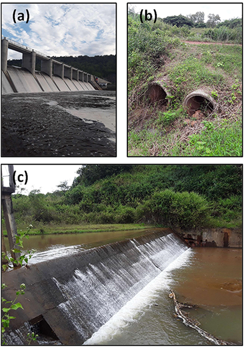
Figure 1. Many rivers around the world have become highly fragmented by hydropower, transport, and irrigation infrastructure, to the detriment of their aquatic biota needing access to various mainstem and floodplain habitats. Management plans and policies are being developed in an attempt to mitigate the barrier impacts of large dams (a) and (to a lesser extent) road crossings (b), but they currently give little-to-no consideration to the impacts of small irrigation structures (c)—even though these structures outnumber large dams by two–four orders of magnitude in most river basins (photos taken by Tim Marsden).
Download figure:
Standard image High-resolution image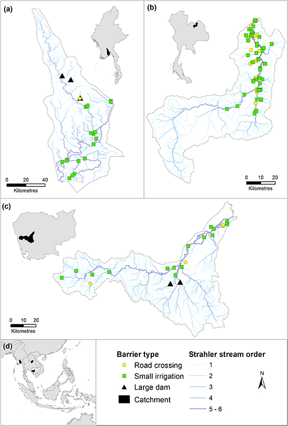
Figure 2. Location of high impact potential road crossing, small irrigation structure and large dam barriers in the Bago (Myanmar—(a)), Huai Luang (Thailand—(b)) and Stung Pursat (Cambodia—(c)) catchments in Southeast Asia (d).
Download figure:
Standard image High-resolution imageWhile this approach may have underestimated the complete number of the three barrier-types, it provided a parsimonious and conservative method for assessing the impacts of the most potentially influential barriers on connectivity in the absence of detailed inventories. In addition, our large dam identification approach identified a greater overall number of large dams than each of the existing global dam databases, and the dam databases themselves all reported different numbers of large dams for each catchment (table 1). The discrepancy between our large dam numbers and those in the global dam databases confirmed the thoroughness of our dam identification approach, and the need for more detailed and accurate barrier inventories for large dams in general.
Table 1. The number of large dams in each catchment (September 2021), as reported by the Global Reservoir and Dam (GRanD) database, Global georeferenced Database of Dams (GOODD), AQUASTAT, International Rivers database, and Global Forest Watch Major Dams database. We have also reported the overall number of large dams identified using our approach, and the number of high impact potential (HIP) ones to demonstrate the thoroughness of our identification approach.
| Catchment | Bago | Huai Luang | Stung Pursat |
|---|---|---|---|
| GRanD | 0 | 0 | 0 |
| GOODD | 4 | 1 | 0 |
| AQUASTAT | 2 | 1 | 0 |
| International Rivers | 2 | 0 | 0 |
| Global Forest Watch Major Dams | 0 | 1 | 0 |
| Our analysis of all large dams | 11 | 1 | 2 |
| Our analysis of HIP large dams | 3 | 0 | 2 |
a Note 1: The GOODD database actually reported three large dams in the Huai Luang, but our large dam identification approach indicated that one of these was actually a road crossing and another appeared to be a misidentification—thus leaving only one as an actual large dam. b Note 2: The Global Forest Watch Major Dams database reported two large dams in the Stung Pursat, but they were under construction at the time of the study and thus not counted by our approach.
2.3. Assessing barrier passability
For each field-validated barrier, we examined the: barrier type, height, and width; bankfull height and stream width at the location; and individual culvert/pipe opening width and number of individual culverts/pipes (where relevant). Each barrier's passability was assessed based on its physical attributes (Kemp and O'Hanley 2010). For weirs and regulators, passability was determined by the height of the barrier as a proportion of the bankfull flow height of the river, to ensure that it was considerate of each site's context (Marsden et al 2014). Large dams were assumed to be impassable when their physical dimensions were known to support this assumption, whereas bridges were assumed to be completely passable and thus discounted (Januchowski-Hartley et al 2013). For culverts and pipes, passability was determined by considering their opening width as a proportion of stream width at each location, since such barriers are typically less passable when they restrict more flow (Marsden et al 2014). Each passabilty result was assigned to one of the following categories (modified from Januchowski-Hartley et al 2013): (a) impassable (passability of ⩾1)—no native species/life stages could pass during most stream flows; (b) low passability (0.5–0.99)—most native species/life stages could not pass during most stream flows; (c) moderate passability (0.25–0.49)—some native species/life stages could not pass during most stream flows; or (d) high passability (<0.25)—potentially all native species could pass during most stream flows.
2.4. Evaluating impacts on connectivity using the dendritic connectivity index (DCI)
The location and passability data were then used to analyse the DCI (Cote et al 2009) resulting from (a) large dams, (b) road crossings, and (c) small irrigation structures, and (d) all three barrier-types together. The DCI can be used to assess distinct development scenarios for both diadromous and potadromous fish species; is robust and easy to apply and interpret (Jumani et al 2020); and has been successfully applied in a range of river connectivity studies (e.g. Bourne et al 2011, Mahlum et al 2014, Shaw et al 2016, Shaad et al 2018, van Puijenbroek et al 2019). It considers the number, passability and placement of barriers within the river network, and yields a value ranging from 0 to 100, where 100 represents maximum connectivity for all migratory species in systems with no barriers (Cote et al 2009). The imposition of a single barrier results in two river reaches, and the DCI is calculated from the lengths of both reaches, the passability of the barrier in both longitudinal directions, and the placement of the barrier within the stream network (Cote et al 2009).
The DCI uses a simple graph approach to represent longitudinal connectivity in a river system, and applies river length (as a proxy for habitat fragment size) to measure the expected connectivity resulting from the location, type and passability of barriers (Cote et al 2009). The DCI diadromous index (DCID—equation (1)) quantifies the probability of fish movement between the outflow point (sink) and a river segment (in both directions); and the DCI potamodromous index quantifies the probability of fish moving freely within the river network both upstream and downstream (DCIP—equation (2)). River connectivity depends on the passability and location of barriers in the river network, with larger impacts expected when barriers are placed downstream splitting equally-sized river segments, or closer to the sink (Grill et al 2014). As the initial passability values in our study were scored using an inverse scale (i.e. 0 was deemed fully passable and 1 was deemed impassable) in accordance with Januchowski-Hartley et al (2013), they were subtracted from 1 prior to being used in the DCI analysis
( —lengths of the river section i and j; L—total length of the river network; M—barriers;
  —upstream and downstream passabilities of the mth barrier, respectively).
2.5. Using the Fish Passage Extension (FIPEX) program to calculate the DCI values
The DCI values were determined using the FIPEX program (Oldford et al 2020) within the GIS software, ArcGIS 10.6.1 (ESRI, Redlands, California, USA). Under the DCI concept, the river network is composed of linear segments connected to each other in both directions (upstream and downstream) and with connections to itself. This river network connects to a downstream exit or outflow point (sink). Further, river segments are split at the barrier locations and each barrier has a set of attributes describing its type (large dam, small irrigation or road crossing) and passability (continuous value between 0 and 1). In the ArcGIS environment, this concept is represented as a geometric network. To calculate the DCI values, it is essential to determine flow direction in the network, and to accurately measure river length upstream and downstream of the barriers (Cote et al 2009).
The geometric networks were created for all DCI calculation scenarios using base stream network layers produced by the Mekong River Commission (https://portal.mrcmekong.org/), for the Thai and Cambodian streams and Open Street Map (www.openstreetmap.org) for the Myanmar streams. These were processed further using the software RivEX 10.35 (Hornby 2010) to determine stream order and identify the sink. Also, spatial analysis operations were undertaken to accurately represent barrier location and derive fragmented river segments; namely, each barrier was snapped onto the network and used to split it into segments. The Geometric Network Editing toolset was used to inspect the network and associated data, to identify disconnected branches due to errors in the network, and loops. This was particularly relevant for our analysis, as the DCI was developed for dendritic networks (i.e. where every river segment has a maximum of one and only one downstream barrier), but the catchments in our study can be characterized as braided due to their respective geomorphology's. Each loop was analysed considering the presence of barriers and the likely flow direction given stream order and connection to other river segments (using satellite imagery for geographical context). The loops were resolved by disabling (or removing) river segments with indefinable flow directions from the DCI analysis. Overall, less than 3% of the total number of network segments had to be disabled, so this procedure would have had a negligible (if any) influence on the study outcomes. Once all issues were resolved and flow direction was established, FIPEX tools were used to summarize river conditions upstream and downstream of each sink and barrier, to produce summary and connectivity tables for the DCI algorithm to use, and finally, to present DCI diadromous and DCI potamodromous values for each catchment and each scenario considered.
2.6. Data analyses
One-way analysis of variance (ANOVAs) were undertaken to determine whether there were any significant scenario-related differences in the average DCI values for diadromous and potadromous fish. The scenarios compared included (a) all HIP barriers, (b) HIP road crossings only, (c) HIP small irrigation structures only, (d) HIP large dams only, (e) all large dams, and (f) all three barrier-types combined (i.e. with all large dams included). Analyses revealing significant effects were interrogated further using Holm-Sidak post-hoc comparisons. All DCI percentages were initially arcsine square-root transformed to meet the assumptions of ANOVA, and the ANOVAs were undertaken using Sigmastat (Systat Software Inc., San Hose, California).
3. Results and discussion
3.1. Has river fragmentation been widely underestimated?
The Mekong River is currently considered to be 'free-flowing' because, apart from the recently-constructed Xayaburi and Don Sahong dams in Lao PDR, the entire lower mainstem is unimpeded by dams (Grill et al 2014). However, although the mainstem is presently largely unimpeded by dams, we found that tributary catchments in the MReCs are highly fragmented by road crossings and small irrigation structures (table 2). Indeed, on average, HIP small irrigation structures contributed 4.5 times as much as HIP large dams to the extent of fragmentation (for both diadromous and potadromous species combined), while the extent of fragmentation from HIP road crossings was essentially equivalent to that from HIP large dams (table 2).
Table 2. High impact potential (HIP) road crossing, small irrigation (SI) structure, and large dam barriers in the three Mekong case study catchments, and their impacts on aquatic connectivity (as indicated by dendritic connectivity index (DCI) scores for each barrier-type in each catchment). The last two shaded columns represent the comparative DCI results for all large dams (i.e. instead of just the HIP large dams) and all three barrier-types combined (using all large dams again, combined with the HIP road crossings and HIP SI structures). DCI scores of 100 were assigned where there were no dams (Cote et al 2009).
| Result | Catchment | All HIP catchment barriers | HIP road crossings | HIP SI structures | HIP large dams | All large dams | All three barrier-types combined (i.e. with all large dams) |
|---|---|---|---|---|---|---|---|
| Numbers | Bago | 23 | 1 | 19 | 3 | 11 | 31 |
| Huai Luang | 94 | 44 | 50 | 0 | 1 | 95 | |
| Stung Pursat | 23 | 3 | 18 | 2 | 2 | 23 | |
| Total barriers | 140 | 48 | 87 | 5 | 14 | 149 | |
| DCI (diadromous) | Bago | 6.5 | 99.7 | 6.5 | 80.3 | 73.2 | 6.5 |
| Huai Luang | 0.1 | 32.5 | 0.2 | 100 | 86.1 | 0.1 | |
| Stung Pursat | 11.3 | 99.8 | 12.2 | 88.4 | 88.4 | 11.3 | |
| Average | 6.0b | 77.3a | 6.3b | 89.6a | 82.6a | 6.0b | |
| DCI (potadromous) | Bago | 21.8 | 99.4 | 27.3 | 67.8 | 57.0 | 18.9 |
| Huai Luang | 22.5 | 66.6 | 23.3 | 100 | 76.0 | 14.2 | |
| Stung Pursat | 38.9 | 99.5 | 46.3 | 79.1 | 79.1 | 38.9 | |
| Average | 27.7bc | 88.5a | 32.3bc | 82.3a | 70.7ac | 24.0bc |
* Average diadromous and potadromous DCI values with the same superscript letters did not significantly differ (unadjusted P > 0.004 for both response variables) according to one-way ANOVA with Holm-Sidak post-hoc comparisons.
Catchment-specific assessments revealed that HIP small irrigation structures had the greatest fragmentation impacts of the three structure-types in each catchment for both diadromous and potadromous species, followed by HIP large dams and then HIP road crossings (with the exception of HIP road crossings having a greater fragmentation impact than HIP large dams in the Huai Luang for diadromous and potadromous fishes). These catchment-specific patterns remained the same even when all large dams were used instead of just the HIP large dams. In addition, the DCI for HIP large dams did not significantly differ from the DCI for all large dams (averaged across the three catchments; table 2)—confirming that the subsets of HIP large dam barriers used in this study were representative of the basin-scale fragmentation impacts from large dams. The consistency of the results for each catchment strengthens our findings, and highlights the potential for underestimating real fragmentation levels if the impacts of small irrigation structures and road crossings are overlooked in favour of those from large dams (sensu Jones et al 2019).
Without appropriate acknowledgement, the potential underestimation of fragmentation is likely to be exacerbated every time planned dam, irrigation structure and road crossing developments proceed. For instance, current modelling suggests that the completion of all planned dams in the Mekong could reduce migratory fish biomass by as much as 70% (Ziv et al 2012, Welcomme et al 2015)—an astounding prediction that does not even consider the impacts of any planned small irrigation structures or road crossings. Similarly concerning predictions have been made for other major river basins around the world—again, based solely on the expected impacts of planned dams and excluding any other planned barrier-types (e.g. Jager et al 2001).
Efforts to restore aquatic ecosystem connectivity will be reliant upon the availability of systematic inventories of the smaller irrigation structures and road crossings present within such basins (Liermann et al 2012, Januchowski-Hartley et al 2013). While several global databases are now available for large dams ((GRanD (Lehner et al 2011), ICOLD (www.icold-cigb.org), and GOODD (Mulligan et al 2020)), there are no equivalent databases for smaller irrigation structures (Liermann et al 2012) or road crossings (Januchowski-Hartley et al 2013). Future research efforts should focus on addressing these knowledge gaps, potentially using automated remote sensing technologies, or dedicated spatial analysis models.
3.2. Small irrigation structures—the sleeping giant affecting river fragmentation?
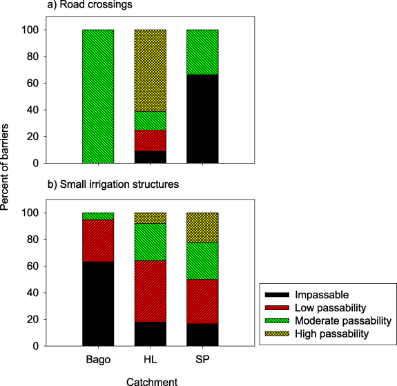
The highly disruptive impact of HIP small irrigation structures in the three case study catchments corresponded with them outnumbering HIP road crossings and HIP large dams at nearly 2:1 and 18:1, respectively (table 2; figure 2). It also aligned with them being generally less passable than road crossings (figure 3). Specifically, 95% of small irrigation structures had low passabilities at best in the Bago, and 10% had high passabilities across all three catchments (cf 21% for road crossings) (figure 3). Furthermore, many of these HIP small irrigation structures were hundreds of kilometres downstream of large dams. This suggests that such structures would be severely impacting many migratory aquatic biota, and have likely already contributed greatly to declines in upstream-migrating fish species.
Figure 3. Percent of road crossings (n = 48) (a) and small irrigation structures (n = 87) (b) that have either high passability (i.e. potentially all native species could pass during most stream flows), moderate passability (i.e. some native species/life stages could not pass during most stream flows), low passability (i.e. most native species/life stages could not pass during most stream flows) or are impassable (i.e. no native species/life stages could pass during most stream flows) in the Bago, Huai Luang (HL) and Stung Pursat (SP) catchments. Results for the large dams were not plotted because they were all impassable.
Download figure:
Standard image High-resolution image
Despite small irrigation structures potentially having a much greater fragmentation impact than large dams, current policies for the development of small irrigation structures are typically much less effective in ensuring that such structures meet environmental compliance standards (Couto and Olden 2018). Indeed, many developing countries currently do not even have any policies and/or environmental compliance standards for small irrigation structures. We argue that the development of irrigation structures—irrespective of their size—should be guided by policies requiring planning and assessment at suitable spatio-temporal scales, since the impacts of such structures will accumulate over basin scales, and manifest over decades (Lange et al 2019).
The predominance of small irrigation structures means that there are a greater number of opportunities to mitigate the impacts of such structures than to remove or improve the passability of large dams, and potentially even road crossings. This could be economically advantageous, since fish passage improvements to small irrigation structures are likely to be much cheaper than those for large dams, owing to the latter requiring more intense design and construction materials (Cooper et al 2019). Nevertheless, it may be more socially acceptable to improve road crossings than large dams or even small irrigation structures, given that the former may provide fewer public benefits (Januchowski-Hartley et al 2013). Such socio-economic implications should be considered along with ecological implications when prioritising the remediation of large dams, small irrigation structures and/or road crossings, by adapting techniques from existing barrier remediation prioritisation approaches that incorporate social and economic factors (Zheng et al 2009, Marsden et al 2014).
3.3. Key differences among patterns for the case study catchments and migratory species groups
The Huai Luang had the lowest connectivity for both potadromous and diadromous species when all three barrier-types were combined (including all large dams and not just the HIP ones), although it had especially low connectivity for diadromous species (the DCID for the Huai Luang was 65 times lower than that for the Bago and 110 times lower than that for the Stung Pursat) (table 2). Closer examination revealed that the Huai Luang has the smallest catchment area, shortest stream length, and lowest drainage density of the three catchments (table 3). Yet, it had the highest total number of barriers at the time of our study (due to its relatively high abundance of HIP road crossings and small irrigation structures), and most of these barriers were located in the lower part of the catchment, downstream of the confluence between the Huai Luang and the Huai Dan river's. According to Cote et al (2009), the spatial effects of barriers on connectivity are typically much stronger for diadromous species than for potadromous species, particularly when the barriers are positioned at the lower end of the river basin. Indeed, just one impassable structure located near the ocean-draining river mouth can be enough to completely prevent diadromous species from being able to access freshwater habitats, and therefore risk causing population declines or even local extinctions (Cote et al 2009, Merg et al 2020).
Table 3. Case study catchment attributes.
| Catchment | Total stream length (km) | Catchment area (km2) | Density drainage (total stream length/area) (km−1) |
|---|---|---|---|
| Bago | 3419.6 | 7787.9 | 0.4 |
| Huai Luang | 1797.2 | 4089.7 | 0.4 |
| Stung Pursat | 3316.7 | 5964.9 | 0.6 |
There were no discernible differences between the ocean-draining Bago catchment and the two river-draining catchments with regards to their connectivity levels for diadromous and potadromous species. Consequently, in this study at least, other catchment-specific factors (especially the stream length in combination with the number, location and passability of barriers) appeared to have a far greater impact on the connectivity levels for diadromous and potadromous species, than each catchment's drainage destination (i.e. ocean versus river). Irrespective of whichever factors were most influential, however, the diadromous populations in the Huai Luang and Stung Pursat would likely be more vulnerable than those in the Bago, due to the greater energetic costs of migration and risk of predation associated with the former populations being more distant from the sea (Merg et al 2020). Future field studies could be strategically designed to empirically validate the main catchment-specific factors influencing connectivity for diadromous and potadromous species, and/or the influence of migration distance (from the sea) on the vulnerability of diadromous populations.
3.4. Conclusion
Growing demand for energy, water, food and transport networks is driving enormous investment into hydropower, irrigation and road infrastructure throughout river basins globally (Alamgir et al 2017, McCartney et al 2019, Barbarossa et al 2020). This immense level of infrastructure investment highlights the acute need for river conservation measures to concomitantly consider the complete fragmentation impacts from such infrastructure. It is imperative that decision makers explicitly consider small irrigation structures and road crossings in addition to large dams when assessing the impacts of river development at catchment scales. For many river basins, this will require expanding inventories of the smaller irrigation structures and road crossings present within such basins, and developing rehabilitation models which think beyond large dams. Unless these steps are taken, the true extent of aquatic fragmentation could be underestimated, and any efforts to conserve or restore connectivity for fish and other aquatic biota may be greatly limited.
Acknowledgments
We thank the many local field staff that assisted with the surveys in Myanmar, Thailand, and Cambodia. This study was funded by the Australian Centre for International Agricultural Research under Project FIS-2014-041.
Data availability statement
The data that support the findings of this study are available upon reasonable request from the authors.