

Abstract
Archaeologists and palaeoclimatologists have focused on the impact of climate on the prehistoric civilizations around the world; however, social resilience in the face of the climate change remains unclear, especially during the Neolithic and Bronze Age in the Central Plains of China (CPC). In this paper, we present palynological results from the Dahecun Core, Henan Province, China. Our pollen data indicate a warm and wet climate condition from 9200 to 4000 cal BP, which then switches to a cool and dry climatic condition during the Neolithic-Bronze Age transition (∼4000–3600 cal BP). We analyze 14C dates from archaeological sites to demonstrate four episodes of population increase and present vegetation dynamics, determined from available pollen data, to provide evidence for the synchronous shifts in vegetation and human population during the Neolithic. Our results indicate that the aridification in the early Bronze Age did not cause population collapse, highlighting the importance of social resilience to climate change. The pollen, radiocarbon dates and archaeobotanical records from the CPC provides new evidence that supports the claim that the development of agriculture and complex societies, under the stress of a dry climate, set the stage for the dramatic increase of human population around 3800–3400 cal BP.
Export citation and abstract BibTeX RIS

Original content from this work may be used under the terms of the Creative Commons Attribution 4.0 license. Any further distribution of this work must maintain attribution to the author(s) and the title of the work, journal citation and DOI.
1. Introduction
Current research has linked the rise and fall of prehistoric complex societies to climate change, implying that climate change determined the success or failure of prehistoric civilizations (Weiss et al 1993, DeMenocal 2001, Kaniewski et al 2019, Sinha et al 2019). However, interactions between prehistoric societies and climate change are much more complex than this deterministic narrative (Munoz et al 2010, Endfield 2012, Armit et al 2014, Contreras 2017, Haldon et al 2018, Xu et al 2019). Numerous cases around the world show during similar shifts in climate, some complex societies collapsed while others flourished (Wang 2004, Butzer and Endfield 2012, Dunning et al 2012, Dong et al 2017). Moreover, when these climatic events occur, different socieites respond using a diverse set of adaptation strategies (Rosen and Rivera-Collazo 2012, Chen et al 2015a, Flohr et al 2016). Archaeological research has revealed that prehistoric societies are quite resilient and flexible to changing environmental and climatic regimes (Marcus 1998, Butzer et al 2012, Li et al 2020). Therefore, it is necessary for the environmental sciences to explain the complexity and diversity of adaptation strategies to periods of climate change in prehistory.
Climate change is often argued to have a direct influence on demographic fluctuations (Li et al 2015, Tallavaara et al 2015, Bevan et al 2017, Xu et al 2019). Previous research has used the summed probability distribution (SPD) of large radiocarbon databases to develop a relative population growth curve that can be matched with paleoclimatic records, examples of this type of research are found in Europe (Shennan et al 2013, Bevan et al 2017, Roberts et al 2019), America (Munoz et al 2010, Riris and Arroyo-Kalin 2019), Australia (Williams 2013) and East Asia (Wang et al 2014, Li et al 2015, Dong et al 2019, Xu et al 2019). However, in the Chinese case, the long-term human responses to environmental change in the Central Plains of China (CPC) are still poorly understood, mainly due to the lack of high-resolution climate records and quantitative proxies of human activity. Here, we report two sets of independent proxies: one is a pollen record from the Dahecun Core in the CPC that ranges from ca. 10000 to 2000 cal BP (figure 1); and the other is a dataset of radiocarbon dates from CPC, which is a proxy of demographic fluctuations and human activity. We compare these two datasets to develop a deeper understanding of the relationship between climate change and human responses.

Figure 1. Topographical map showing the locations of the Dahecun Core (red star) and radiocarbon dates from Neolithic and Bronze Age archaeological sites in Central Plains of China. The data set of the background map is provided by International Scientific & Technical Data Mirror Site, Computer Network Information Center, Chinese Academy of Sciences (www.gscloud.cn).
Download figure:
Standard image High-resolution image2. Regional setting
The CPC has been regarded as the 'Cradle of Chinese Civilization' (Yan 1987, Zhao 2000), making it an ideal region to examine the relationship between past climate change and human populations growth and decline. The first two decades of the 21st century have seen an enormous upsurge in archaeological work in this region. Enormous quantities of new data, including 14C dates from various landforms across the CPC have been generated from archaeological excavations as a result of China's fast pace of economic development (Wang et al 2014, Liu et al 2019a).
Regional vegetation is characterized by coniferous-deciduous forests and shrubs found in mountainous areas, including Pinus tabulaeformis, Pinus bungeana, Abies chensiensis, and Betula albo-sinensis. At lower elevations, broad-leaved deciduous forests are common, including Ulmus pumila, Populus tomentosa, Salix matsudana and Robinia pseudoacacia. Eleocharis acicularis, Salix sinopurpurea and Typha spp. are common in wetlands (Wang et al 1989, Zhang et al 2018a, Ren et al 2019).
The CPC has experienced six major Neolithic and Bronze Age archaeological cultures dating from ca. 9000 to 3000 cal BP: Peiligang (ca. 9000–7000 cal BP), Yangshao (ca. 7000–5000 cal BP), Longshan (ca. 5000–3900 cal BP), Erlitou (ca. 3900–3500 cal BP), Early Shang (Erligang, ca. 3600–3300 cal BP) and Late Shang (Yinxu, ca. 3300–3000 cal BP) (Liu and Chen 2012). Regional archaeological surveys have shown fluctuations in population size and settlement patterns during the Holocene (Liu et al 2019a). Compared to the Yangshao culture, there are many more Longshan archaeological sites, suggesting a significant increase in population size (Liu 2004). The Erlitou culture is characterized by its large elite palaces, numerus turquoise and bronze artifacts, and is widely recognized as the first state-level society in China (IACASS 2014, Zhang et al 2019). Current evidence of craft production at the Erlitou site indicates that it was inhabited by a socially and economically diverse population that likely fulfilled a variety of specialized services for wider society during the early Bronze Age (Liu and Chen 2012).
3. Materials and methods
3.1. Sampling strategy and stratigraphy
In the spring of 2008, our team drilled a core at Dahecun, an archaeological site located to the northeast of Zhengzhou. The Zhengzhou region is on the boundary of the Loess Plateau and North China Plain. It is surrounded by the Yellow River to the north, the Songshan Mountains to the southwest, and the North China Plain to the east. The annual precipitation is about 650 mm, and the annual mean temperature is 14.4 °C (Zhengzhou Committee of Chorography 1999).
Dahecun is located on the west edge of the North China Plain. Originating from the southwestern hilly area, the Jialu River flows to the northeast of Dahecun. The Dahecun core is situated on the floodplain of the Jialu River. Geological survey has found that the strata of this area are composed of alluvial or paleochannel deposits that formed during the early Holocene. During the middle Holocene, lacustrine or swamp deposits formed throughout the area before these deposits were buried by alluvial deposits during the late Holocene (Liu 1992, Yu et al 2016, Li et al 2019b). The ancient lake around Dahecun is estimated to be 61 km2 large during the mid-Holocene (Yu et al 2016). The location of the Dahecun core was selected to avoid direct inflow, ensuring continuous deposition of the sediments. The core is 334 cm long and the lower 296 cm was sampled at 2 cm intervals for pollen analysis. The sediments are mainly dark grey silt and fine silty sand, interpreted as a lacustrine or swamp deposit.
Lithologic layers:
- (a)334–324 cm, coarse sand layer, containing some root pores and small pieces of charcoal.
- (b)324–262 cm, grey yellowish clayey silt layer, mixed with sand and organics. The lower part of this layer is a dark sediment that contains carbonate nodules.
- (c)262–124 cm, mottled silt layer with fragments of coarse sand, containing pieces of charcoal.
- (d)124–78 cm, dark grey silty clay layer.
- (e)78–38 cm, complex of grey yellowish clayey silt and black clay, containing burned earth.
- (f)38–0 cm, yellowish to mottled (black specks) fine sand, containing the cultural remains including pieces of pottery that stylistically date to the Han dynasty (202 BCE–220 CE) and burned earth.
3.2. Radiocarbon dating and Pollen analysis
We collected five samples for accelerator mass spectrometry (AMS) radiocarbon dating. They were dated at the Xi'an AMS Center, China.
A total of 149 sediment samples from the Dahecun Core were selected for pollen analysis. All samples were treated with HCl, KOH, HF and acetolysis (Fægri and Iversen 1989, Moore et al 1991). To calculate pollen concentration, we added one Lycopodium spore tablet to each sample to serve as a marker. We excluded four samples which contained less than 100 pollen grains. Approximately 150 pollen and spore grains were counted for the remaining 145 samples. Pollen percentage diagrams were constructed using the TILIA (www.tiliait.com/, version 2.6.1, published in 2019) software.
The pollen and spores recovered from these sediments were transported by air, rainout, and surface runoff, with contributions from inflows of Jialu River. As previous research has pointed out, pollen preserved in lacustrine-alluvial sediments can come from both local vegetation and upstream sources (Zhu et al 2003, Brown et al 2007), therefore we consider that the Dahecun pollen signals reflect both local and regional vegetation.
3.3. Radiocarbon dates from archaeological sites in Central Plains of China
The uncalibrated 14C dates were screened using the criteria described by Wang et al (2014). We eliminated the following dates: (a) dates with high error bars (1σ standard deviation of the 14C ages >400 years); (b) dates derived from soils, shells, other unknown materials, or materials unsuitable for dating; (c) dates that had weak associations with human occupation or settlements such as temples, pagodas or canoes. If the dates were derived from different materials in the same context at a site, we selected the most reliable dating material. The 14C database of the CPC contains 754 dates from 89 sites (figure 1). Most dates were derived from the 14C database for China (N = 4656) (Wang et al 2014). The 754 dates from CPC (∼0.167 million km2) exceed Williams' (2012) suggested minimum sample size of 500 in a much larger region (∼7.69 million km2), and thus the dataset we used can mitigate site- and period-level biases (Gamble et al 2005, Shennan and Edinborough 2007, Williams 2012). Therefore, we conclude that these dates reliably reflect changes in human activity and population dynamics in CPC.
The linkage between the SPD of large radiocarbon databases and human population is based on the proposition that the production and deposition of carbonized cultural material increases as population size increases, thus producing more material for radiocarbon dating (Munoz et al 2010, Bevan et al 2017, Xu et al 2019). The core assumption of this technique (more people → more datable samples → more radiocarbon dates) has been critically discussed, from the taphonomic loss of samples to the false signals linked to small sample sizes (e.g. Surovell et al 2009, Williams 2012, Contreras and Meadows 2014). Some of these problems can be solved by means of a hypothesis testing method introduced in Shennan et al (2013), and Timpson et al (2014). Their approach developed a statistical testing framework, where the observed SPDs are compared against a statistical confidence envelope of a fitted model (Crema et al 2016, Crema 2019). We use R package rcarbon to generate SPD of radiocarbon dates and to test observed SPDs against theoretical models (Bevan and Crema 2021, R Core Team 2019). A detailed description of these methods can be found in Shennan et al (2013) Timpson et al (2014), Crema et al (2016), Bevan et al (2017), Crema and Bevan (2021).
4. Results
4.1. Chronology and pollen assemblages
The Dahecun Core yielded five radiocarbon dates (table 1). Based on the relative dating of the pottery sherds (202 BCE–220 CE) excavated from depth 38 to 20 cm in layer f, the age of the boundary of cultural layer (layer f) and alluvial deposit (layer e) was estimated to ca. 2000 BP. An age-depth model was established through a Bayesian age model of these five AMS dates and one estimated date (figure 2). The age-depth model fit well with lithostratigraphic correlation with the adjacent cores (Liu 1992, Yu et al 2016, Wang et al 2019).
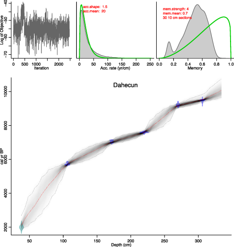
Figure 2. Age-depth relationship of the Dahecun Core based on Bayesian age model obtained by Bacon 2.3 (Blaauw and Christen 2011), using the IntCal13 atmospheric curve (Reimer et al 2013).
Download figure:
Standard image High-resolution imageTable 1. Result of AMS-radiocarbon dating from the Dahecun Core, calibrated using CalPal (www.calpal-online.de).
| Lab. no. | Field no. | Depth (cm) | Dating material | δ13C (‰) | 14C age (a BP) | Calibrated age (cal BP) | ||
|---|---|---|---|---|---|---|---|---|
| δ13C | Error (1σ) | 14C age | Error (1σ) | |||||
| XA3327 | Z2 53 | 106 | Soil OM | −16.76 | 0.61 | 4989 | 29 | 5714 ± 39 |
| XA3328 | Z2 86 | 172 | Charcoal | −15.84 | 0.2 | 6137 | 27 | 7062 ± 75 |
| XA3326 | DHC04 | 220 | Soil OM | −20.66 | 0.45 | 6736 | 32 | 7608 ± 23 |
| XA3338 | Z2 135 | 270 | Soil OM | −18.04 | 0.18 | 8252 | 30 | 9224 ± 63 |
| XA3331 | Z2 153 | 306 | Soil OM | −22.67 | 1.16 | 8470 | 61 | 9484 ± 38 |
The pollen record from Dahecun Core is illustrated in figure 3. From ca. 10000 to 4000 cal BP, the regional vegetation was dominated by various trees, including Pinus, Betula, Abies, Tsuga, Alnus, Quercus, and Juglans. According to the recovered pollen assemblages and the cluster analysis, there are three major vegetation zones:
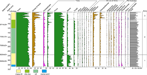
Figure 3. Pollen diagram of major pollen types for the Dahecun Core. The green, brown and purplish red represent trees, shrubs and herbs, and pteridophytes, respectively.
Download figure:
Standard image High-resolution imageZone 1 (334–270 cm, ca. 10000–9200 cal BP). This zone is dominated by conifer (e.g. Pinus, Tsuga, Alnus) and broadleaved trees (e.g. Betula, Juglans, Quercus). There is an increase of Betula and Juglans at the expense of Tsuga and Alnus at ca. 9530 cal BP. The high percentage of Pinus, Betula indicate cool and wet climate conditions.
Zone 2 (270–75 cm, ca. 9200–4000 cal BP). While Pinus still comprises more than 50% of the pollen percentage, this zone is marked by a rapid decrease in Betula pollen. The percentage of Tsuga and Polypodium exhibit an increasing trend compared with Zone 1, indicating a warm and humid conditions. The relatively high percentage of the Pteridophytes taxa shows that the lake level was stable at this stage.
Zone 3 (75–38 cm, ca. 4000–2000 cal BP). This zone is marked by the increasing trend of Artemisia and Chenopodiaceae at the expense of trees, such as Pinus, Alnus, Tsuga, and Quercus. The percentage of Pinus decreases in the lower part and increases in the upper part again. The decrease of various trees and increase of drought-tolerant taxa such as Artemisia and Chenopodiaceae imply a fluctuating cool and arid environment.
4.2. Demographic history
The SPD curve for the CPC exhibits several episodes of demographic fluctuations, with four peaks (8100–7600, 5600–5000, 4200–4000, 3800–3400 cal BP), and four declines (7500–6500, 5000–4500, 4000–3900, 3400–3000 cal BP) (figure 4). When incorporating the demographic fluctuations with cultural changes, it is notable that population increases when the archaeological cultures flourish. The first demographic peak (ca. 8100–7600 cal BP) corresponds with the rise of the Peiligang Culture and the formation of early millet-based agriculture (Zhao 2014, Ren et al 2016, He et al 2017). The second peak was the late Yangshao (ca. 5600–5000 cal BP), when the number of settlements quickly increased (Liu 2004). The third peak was the late Longshan (4200–4000 cal BP), characterized by the emergence of a complex chiefdom organization (Liu et al 2019a). The fourth peak was the Erlitou and early Erligang period (3800–3400 cal BP), marking the emergence of the earliest states in China (Liu and Chen 2012).
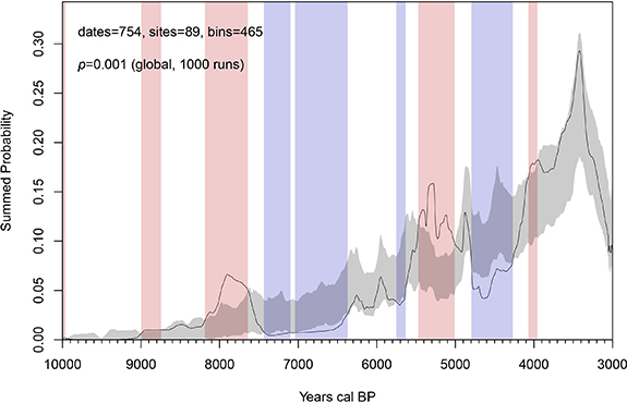
Figure 4. A summed probability distribution (SPD) of radiocarbon dates in Central Plains of China (solid black line) compared with Monte-Carlo envelope of equivalent random samples drawn from a fitted logistic growth model of population growth (the grey band). Red and blue bands represent areas where the observed SPD significantly deviates from the logistic model (red bands are those where population exceeds the expectations of the logistic model, blue bands are those where population is beneath expectations).
Download figure:
Standard image High-resolution imageThe four episodes of population decline indicate periods of cultural transition. The first was during the late Peiligang to the early Yangshao transition (ca. 7500–6500 cal BP), and the second was during the early Longshan period ca. 5000–4500 cal BP. The third population decrease around 4000–3900 cal BP corresponds with the transition from the late Longshan to Erlitou Culture. The fourth decline from ca. 3400 to 3000 cal BP can be interpreted in two ways. One interpretation is that the political center moved to Anyang Yinxu in northern Henan during the second half of the Shang dynasty, resulting in a large scale migration of people from central Henan to Anyang and its surrounding area (Liu and Chen 2012). The other interpretation of this shift is that more archaeological sites are dated by ceramic typologies and historical documents instead of radiocarbon dates in late Bronze and Iron Age, which are reflected in the decline of the SPD for the younger ages after 3400 cal BP. The decline of the SPD in late Bronze Age can also be seen on the Chinese Loess Plateau (Li et al 2015).
Our results fit well with known fluctuations in settlement patterns in the Yiluo region of the CPC, reflected in changes in site number and AMS dates analyzed using the SPD method. The full-coverage regional survey by Liu et al (2019a) has shown the population peaks in the late Yangshao, late Longshan, and Erlitou period (Liu et al 2019a). However, this trend is different from the population estimation based on the numbers of archaeological sites of the whole China, which indicates a population decrease during the Erlitou period (Hosner et al 2016 see figure 5, Leipe et al 2019 see figure 3). This difference might be due to regional variability. Additionally, the mean size of archaeological sites during the Erlitou period is larger than the Longshan period, which also should reflect changes in the estimated population size (Liu et al 2019a).
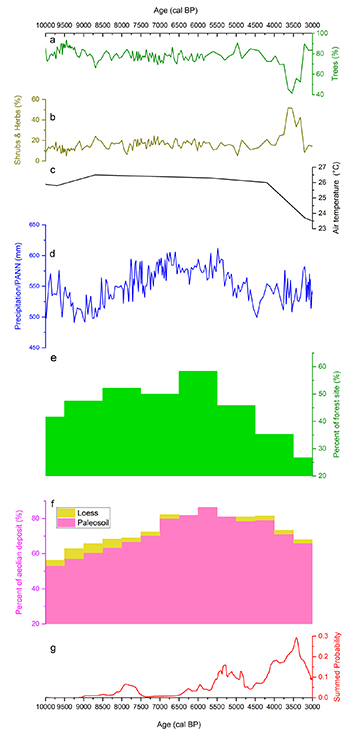
Figure 5. Comparison of the reconstructed vegetation dynamics, air temperature, annual precipitation and demographic fluctuations in Central Plains of China (CPC) with other large-scale vegetation history and regional paleoclimatic records. (a) Percentage of tree pollen (%) from Dahecun Core. (b) Percentage of shrub and herb pollen (%) from Dahecun Core. (c) Air temperature reconstructed based on GDGTs from the Mangshan loess plateau (Peterse et al 2011). (d) Pollen-based annual precipitation (PANN) reconstructed from Gonghai Lake (Chen et al 2015b). (e) Percentage of forest type in north-central China (Li et al 2019a). (f) Moisture index synthesis reconstructed from the sedimentary facies of aeolian deposits in the East Sandy Land in northern China (Li et al 2014). (g) A summed probability distribution (SPD) of radiocarbon dates in CPC as proxy for demographic fluctuations.
Download figure:
Standard image High-resolution image5. Discussion
5.1. Vegetation dynamics, climate change and demographic fluctuations
Vegetation dynamics, demographic fluctuations and climate change over the course of the Holocene are illustrated in figure 5. Pollen records reveal that the changing ecosystems of the region are associated with demographic fluctuations. A major climatic shift around 9200 BP changed the temperature and moisture availability, and led to the expansion of Tsuga (figure 3). Precipitation reconstruction from Gonghai Lake, located in Shanxi Province, also indicates a more humid climatic condition from ca. 9000 cal BP (figure 5(d), Chen et al 2015b). The first two visible increases in population size, from ca. 8100–7600 to 5600–5000 cal BP, correspond with tree dominated vegetation cover, which indicates a warm and humid climate during the mid-Holocene. The environment during the mid-Holocene was characterized by an increase in moisture availability, with high values of Tsuga and Alnus, and increases of some taxa prefer to wet habitats, such as Myriophyllum and Polypodium. Tsuga decreased abruptly around 4500 cal BP, while the pollen percentage of herbacous plants (Artemisia, Chenopodiaceae) increased (figure 3). A climate shift at ca. 4500–4000 cal BP is also seen across other parts in north-central China (Chen et al 2015b, Zhang et al 2018b).
Several cultural and demographic changes correspond with major shifts in climate and ecosystems. The rise of the Peiligang culture at ca. 9000 BP coincides with the replacement of the cold-tolerant taxa (Betula) with the thermophilous and hygrophilous taxa such as Tsuga and Alnus. There is a clear signal for the precipitation decline around the 5000 cal BP climate event (Feng et al 2006, Chen et al 2015b, Xu et al 2017), when the pollen abundance of trees rapidly decreases (figure 5(a)). This may have caused a food shortage and resulted in the Yangshao–Longshan transition and the subsequent population decline during the early Longshan period (5000–4800 cal BP). The population decrease in early-late Longshan cultural transition time (ca. 4500 cal BP) coincides with more serious aridity and a sharp decrease in Tsuga (figure 3). A decline in trees and an increase in various other herb taxa (e.g. Artemisia, Chenopodiaceae) at ca. 4000 cal BP occurred at the same time as the transition from Longshan culture to Erlitou culture and the third population decline (4000–3900 cal BP). Demographic changes occur at each environmental-cultural transition, suggesting that the vegetation dynamics, climate change, cultural transitions and demographic fluctuations are closely linked.
Overall woodland species are relatively stable at around 70%–90% throughout the early Holocene up to ca. 9000–3900 cal BP, but then herb taxa increase approximately coincident with the increase in archaeological radiocarbon at the start of the Early Bronze Age. The amount of non-arboreal taxa doubles at the start of the Bronze Age, from ca. 25% to 50% of the pollen abundance, at the expense of arboral taxa, like Tsuga, Pinus, and Alnus. There is a synchronous non-arboreal taxa and radiocarbon-inferred population peak at ca. 3500 cal BP. Non-arboreal taxa appears to decrease rapidly, followed by a period between 3200 and 3000 cal BP when vegetation remains stable. The air temperature reconstruction based on branched glycerol dialkyl glycerol tetraethers (GDGTs) from Mangshan loess plateau in CPC indicates a cooling climate condition after 4000 cal BP (figure 5(c), Peterse et al 2011). Independent moisture index synthesis reconstructed from the sedimentary facies of aeolian deposits in the East Sandy Land of northern China (figure 5(f), Li et al 2014) shows that summer monsoon intensity decreased after 4000 cal BP, which may have had a significant role in increasing aridity and subsequent forest decline. This can be supported by a large-scale palaeovegetation reconstruction which suggested that forest vegetation flourished during 9000–4000 cal BP but decreased thereafter in north-central China (figure 5(e), Li et al 2019a). Population increases, however, should have accelerated the trajectory of forest degradation from the early Bronze Age onwards (figure 5). Thus, deforestation between ca. 3800 and 3500 cal BP was due to the combination of increasing aridity and human activities, which was initiated by decreased monsoon intensity beginning in the late Neolithic (Zhao et al 2009, Ren et al 2019).
5.2. Evidence of social resilience to past climate change
The comparison of the pollen, paleoclimate and archeological data shows that population size rapidly increased from 3800 to 3400 cal BP, during a cold and arid period. This period is defined by the transition from millet-based agriculture to a multiple crop system, which would have facilitated demographic growth by increasing food resources (Lee and Bestel 2007, Lee et al 2007, Zhao 2007, Liu et al 2019b).
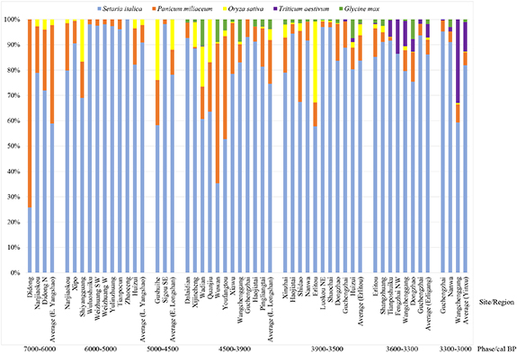
Flotation results summarized in figure 6 show the development of agriculture on the CPC. Archaeobotanical research has revealed a transition from a hunting and gathering dominated subsistence strategy to an subsistence economy dominated by sedentary agriculture during the mid-late Yangshao period (6000–5000 BP) (Zhao 2014), which should be one factor driving the distinct peak in human population around 5600–5000 cal BP. During the late Longshan period (4500–3900 cal BP), the crop mainly cultivated is foxtail millet (Setaria italica), supplemented with broomcorn millet (Panicum miliaceum), rice (Oryza sativa), and soybean (Glycine) (Zhang et al 2014, He et al 2017). During the Erlitou period (3900–3500 cal BP), wheat (Triticum aestivum) was introduced into the CPC, but its proportion in the main crops remained low (see figure 6, Zhao 2007, Zhang et al 2014, Long et al 2018, Liu et al 2019b). From 3900 to 3500 cal BP, the abundance ratio of rice from the flotation results also steadily increased, especially at the Erlitou site (Lee and Bestel 2007, Zhao 2007, Zhang et al 2014). This may indicate an advancement in water management technologies. During Erligang period (3600–3300 cal BP), the proportion of wheat visibly increase, showing its more and more significant role in food resource (Lee et al 2007, Zhao 2007, Zhang et al 2014). The higher yield per unit area of wheat and rice compared with millets and the increasingly diverse agricultural system contributed to the growing resilience towards instable climatic conditions after 3900 cal BP. Similar strategies were found in the northeastern Tibetan Plateau of China, where farmers used a risk reduction strategy based on crop diversification which included cultivating cold-tolerant wheat and barley faced with the 4000 cal BP climatic cooling (d'Alpoim Guedes and Bocinsky 2018).
Figure 6. Abundance ratio of crops from the flotation results in Central Plains of China: Didong and Didong N (Wei 2014), Nanjiaokou (Qin 2009), Xipo (Zhao 2011), Shiyangguan (Fuller and Zhang 2007), Wuluoshuiku, Weizhuang SW, Weizhuang W, Yulinzhuang, Tianpocun and Zhaoceng (Lee et al 2007), Huizui (Lee and Bestel 2007, Zhang et al 2014), Gushuihe (Fuller and Zhang 2007), Sigou SE (Lee et al 2007), Dalaidian (Wu 2016), Xijincheng (Chen et al 2010), Wadian (Liu et al 2018), Quanjiu (Wei 2014), Wuwan, Youfangtou, Xiawu and Shidao (Fuller and Zhang 2007), Wangchenggang (Zhao and Fang 2007), Guchengzhai (Chen et al 2012), Haojiatai and Pingliangtai (Deng and Qin 2017), Xinzhai (Zhong et al 2016), Dongzhao (Yang et al 2017), Nanwa (Wu et al 2014), Erlitou (Zhao 2007), Luokou NE, Shaochai, Shangzhuang and Fengzhai NW (Lee et al 2007).
Download figure:
Standard image High-resolution image
Another aspect that can explain the dramatic demographic growth from 3800 to 3400 cal BP is the rise of state-level complex societies in the CPC during the Erlitou and Erligang period. The capitals of Erlitou culture and Shang dynasties are all located on the CPC and facilitated population nucleation (Liu and Chen 2012). The size of the largest site expanded from 70 ha in late Longshan period to 300 ha during the Erlitou period (Liu et al 2019a), also mirrors the SPD graph of AMS dates.
6. Conclusion
Climate fluctuations have played significant roles in the population dynamics during the early and middle Holocene (ca. 10000–3900 cal BP). However, social resilience to external challenges, especially the diverse agricultural system and development of the complex societies to a highly centralized dynastic heartland in Chinese civilization, ultimately determined the trajectories of demographic fluctuations in the late Holocene (3800–3000 cal BP).
Confronted with the fluctuation and limitation of resources caused by episodes of climatic aridification, like food shortages for example, people in the CPC had two ways to survive. Firstly, the number of cultivated plants expanded to include foxtail millet, broomcorn millet, wheat, soybean and rice, which reduced the risk of food production. Secondly, population nucleation as a result of the first dynastic states in China also benefited the protection of the existing resources. In sum, the development of agriculture and the formation of earliest dynastic states in China has greatly contributed to the dramatic increase in population during the early Bronze Age.
Acknowledgments
The authors appreciate the constructive comments from three anonymous reviewers and guest editor. We are grateful to Professors Zhengtang Guo, Wenying Jiang, Limi Mao, Houyuan Lu, Haibin Wu, and Drs Yanyan Yu, Qian Hao, Deke Xu, Wenchao Zhang for their helpful discussion. This paper is dedicated to the memory of Professor Kunshu Zhou for his initial design and enlightenment. Speical thanks to Professor Fuhua Yan for his assistance in the laboratory. Xiaolin Ren would like to thank Dr Enrico Crema and Dr Erik Gjesfjeld for their kindly organising 'Big Data in Archaeology: R Workshop' on 26th March 2019 in Cambridge, UK. This work was supported by the National Natural Science Foundation of China (Grant Nos. 41888101, 41690114, 41907374, 41877441, 41671014), the Strategic Priority Research Program of Chinese Academy of Sciences (Grant No. XDB26000000), the National Social Science Foundation of China (Grant No. 18CKG003), the Zhengzhou Environmental Archaeological Research Project, the Digital Environment Archaeology Specially-appointed Researcher of Henan, China, and the European Research Council (ERC) under the European Union's Horizon 2020 research and innovation programme ('The Wall' project, Grant Agreement No. 882894).
Data availability
The data that support the findings of this study are available upon reasonable request from the authors.