

Abstract
Droughts in South Asia pose substantial challenges to water resources, agricultural, and socio-economic growth of more than two billion people. However, the most detrimental soil moisture droughts, their impacts, and occurrence in the observed and projected climate in South Asia remain unidentified. We conducted soil moisture simulations using the variable infiltration capacity model and meteorological forcing based on the four global observational products (Climate Research Unit, WATCH-Forcing-Data-ERA-Interim, University of Delaware, and Princeton) to identify the worst soil moisture drought during 1951–2016. The worst soil moisture drought during the observed record occurred in 2002 and affected more than 65% of South Asia and resulted in a decline in rice yield (∼400 kg ha−1). A large uncertainty based on the four observational products was found in the number of drought spells and their characteristics. We estimated the frequency of droughts that exceeded the overall severity score of the worst drought during 1951–2016 under the future climate using 40 simulations from Community Earth System Model-Large Ensemble. The frequency of the worst droughts is projected to increase by about 1.5 times in the future (2035–2100) in comparison to the historic (1951–2016) climate. The worst droughts in the future are likely to be more intense and widespread in South Asia. A considerable influence of industrial aerosols was found on the occurrence of the worst droughts in South Asia. Our findings have implications for food and water security in one of the most densely populated regions in the world.
Export citation and abstract BibTeX RIS

Original content from this work may be used under the terms of the Creative Commons Attribution 4.0 license. Any further distribution of this work must maintain attribution to the author(s) and the title of the work, journal citation and DOI.
1. Introduction
South Asia (India, Pakistan, Nepal, Bangladesh, Bhutan, and Sri-Lanka) has faced detrimental droughts that affected water availability, agricultural activities and disrupted the lives of more than 1.5 billion people (Ahmad et al 2004, Dey et al 2011, Kumar et al 2013, Mishra et al 2016, Aadhar and Mishra 2017). Droughts over South Asia are mainly driven by the failure of the summer monsoon (June–September), which is a lifeline for the millions of people in the region and provides about 80% of the total annual rainfall. The year-to-year variability of the summer monsoon precipitation in South Asia is linked with the large scale atmospheric and oceanic variability, most notably El-Nino Southern Oscillation (ENSO) and Indian Ocean Dipole (Mishra et al 2012, 2020, Roxy et al 2015, Singh et al 2019). The weakening of the summer monsoon season results in meteorological droughts, which, if prolonged, can turn into hydrological and agricultural droughts (Shah and Mishra 2015, 2020a). South Asia witnessed several major droughts during the observed climate (Ahmad et al 2004, Dey et al 2011, Kumar et al 2013, Mishra et al 2016, Aadhar and Mishra 2017), which led to famines in the 19th and 20th centuries (Mishra et al 2019).
Increased air temperature and the weakening of the summer monsoon resulted in severe and intense droughts that affected food production in South Asia (Milesi et al 2010, Lobell et al 2012, Davis et al 2019, Mishra et al 2020). Moreover, the increased temperature during the post-monsoon season (October–December) poses even more challenges due to the depletion of soil moisture after the monsoon season droughts (Mishra 2020b). Mishra (2020b) reported that increased air temperature during the post-monsoon season accelerated soil moisture deficit over India, leading to the post-monsoon season drying during the 1951–2018 period. Anthropogenic warming has significantly contributed to recent droughts (AghaKouchak et al 2014, Diffenbaugh et al 2015, Chen and Sun 2017), which were amplified by the land–atmospheric interactions due to changes in the water and energy budgets (Trenberth et al 2014). Anthropogenic warming has substantial impacts on droughts (AghaKouchak et al 2014, Diffenbaugh et al 2015, Chen and Sun 2017, Mishra 2020b) and soil moisture deficit (Lorenz et al 2010, Seneviratne et al 2010, 2013). In addition, the frequency of droughts is projected to rise in South Asia under the warming climate (Aadhar and Mishra 2020). Therefore, both climate warming and failure of the summer monsoon can cause concurrent dry and hot extremes, which are projected to increase under the future climate (Mishra et al 2020).
Understanding the drought risk in South Asia is vital for food and water security in one of the most populated regions in the world. Drought risk has been changing under the observed and future climate in South Asia (Aadhar and Mishra 2020, Mishra et al 2020). However, it remains unclear how the frequency and severity of the worst droughts in the observed climate that affected surface and groundwater resources, agricultural production, and economic growth in the region will change under the warming climate over South Asia. Notwithstanding that the major droughts posed profound challenges in all the spectrum of lives in South Asia in the past, little is known about their characteristics and drivers under the warming climate in the future. Moreover, the role of anthropogenic warming on the major droughts in South Asia has not been systematically examined. We do not know if anthropogenic activities such as emissions of greenhouse gases and industrial aerosols will worsen the risk of the major droughts in South Asia or not. In addition, there may be considerable uncertainty in the characteristics of the worst droughts in different observational datasets, which has not been carefully evaluated over South Asia.
Here, we examine the worst soil moisture droughts that occurred during the observed climate (1951–2016) using four global datasets based on observations. Then, we estimate the change in the frequency and occurrence of severe soil moisture droughts in the future climate using the Community Earth System Model 1 Large Ensemble (CESM-LENS) simulations. We used large ensemble simulations as the complete understanding of the characteristics of the worst drought is not possible in the limited record length due to its low probability of occurrence. We address the following questions: (a) when did the worst soil moisture drought occur over South Asia during the observed climate of 1951–2016? (b) To what extent do the characteristics of the worst soil moisture drought differ in different observational datasets? (c) How likely is the occurrence of the observed worst drought under the warming climate, and to what extent do the anthropogenic activities (greenhouse-gas emission and industrial aerosol) affect these in South Asia?
2. Data and method
2.1. Observed data
We obtained precipitation, maximum and minimum temperatures, and wind speed at 0.5° spatial resolution from the four global datasets [Climatic Research Unit (CRU-v4.02) (Harris et al 2020), Princeton Data (Sheffield et al 2006), University of Delaware (UDEL-v5.01) (Legates and Willmott 1990), and WATCH-Forcing-Data-ERA-Interim (WFDEI) (Weedon et al 2014)] for South Asia for 1951–2016. These datasets are developed using different methods and observations to prepare the gridded data of precipitation, temperature, and wind speed. For instance, CRU data was developed using the angular-distance weighting interpolation method on the monthly climate anomalies from a large network of observed stations (Harris et al 2020). Princeton forcing data was developed by combining the number of global observation-based datasets (station and satellite-based) and National Centers for Environmental Prediction–National Center for Atmospheric Research reanalysis (Sheffield et al 2006). The UDEL data was developed using the global gauge measurements from Global Historical Climatology Network, Global Synoptic Climatology Network archive, Global Surface Summary of Day, and station observations from different countries (Legates and Willmott 1990). The WFDEI meteorological data was developed using the WATCH forcing data (WFD) based on the bias-corrected ERA-40 reanalysis (Uppala et al 2005, Weedon et al 2014). These datasets have been widely used in the previous drought assessments (Sheffield et al 2009, Wang et al 2011, Hoerling et al 2012, Stagge et al 2017) and other hydroclimatic extremes (Ali et al 2018, Aadhar and Mishra 2019, Philip et al 2020). Using daily precipitation, maximum and minimum temperatures, and wind speed from the four observational datasets, we developed the four sets of meteorological forcing for variable infiltration capacity (VIC; version: 4.1) model to simulate the soil moisture for the period 1951–2016 (please see supplemental text S1 for more details (available online at stacks.iop.org/ERL/16/024050/mmedia)). We also used rice yield and vegetation index data to evaluate the impact of worst drought on agriculture productivity. Rice yield data was obtained from the Food and Agriculture Organization (FAO; www.fao.org/faostat/en/#data/QC) for India, Pakistan, Sri Lanka, Nepal, Bhutan, and Bangladesh for the period 1961–2016. We also used the Normalized Difference Vegetation Index (NDVI) data based on Advanced Very High-Resolution Radiometer (AVHRR) sensor from National Oceanic and Atmospheric Administration (NOAA) for the period 1982–2016.
2.2. VIC model
The VIC model (Liang et al 1994, 1996b, Cherkauer et al 2003) is a physically-based land surface hydrological model that is used to simulate the sub-daily or daily soil moisture for each grid using full water and energy budget modes. We set up the VIC model at 0.5° spatial resolution and simulated daily soil-moisture using the full water budget mode for the period 1951–2016. Soil moisture in the VIC model is simulated in the three soil layers using Richard's equation, where the top two soil layers contribute to surface runoff. The VIC model does not consider any lateral flow from one grid to another. The bottom (third) soil layer contributes to the baseflow and considers the gravity-based drainage. Soil moisture simulated using the VIC model considers the sub-grid variability of vegetation, topography, and storage capacity (Liang et al 1996a). We obtained the vegetation parameter from NOAA-AVHRR (Hansen et al 2000) and derived soil parameters using the Harmonic World Soil Database. The calibrated soil parameters for the Indian sub-continent basins were used from Mishra et al (2019). Moreover, we evaluated the VIC simulated soil moisture using the satellite-based soil-moisture (Global Land Evaporation Amsterdam Model; GLEAM). The VIC simulated soil-moisture performs well compared to the GLEAM (Martens et al 2017) soil moisture during the period 1980–2016 (figure S1). The GLEAM soil moisture is based on the assimilation of satellite-based soil moisture. We find that all the products capture the year-to-year variability in soil moisture, however, there are large differences in the soil moisture trends due to different observations (figure S1). Moreover, GLEAM uses satellite-based soil moisture, dynamic vegetation, and considers the role of human influence (e.g., irrigation) in soil moisture estimation. As soil moisture simulations conducted using the VIC model did not consider the role of human influence, the differences between the VIC and GLEAM soil moisture are expected. The VIC model has been widely used to reconstruct the historical droughts and estimation of soil moisture in the previous studies (Sheffield 2004, Mishra and Cherkauer 2010, Nijssen et al 2014, Shah and Mishra 2015).
2.3. Community earth system model-large ensemble
We used daily meteorological forcing (precipitation, minimum temperature, maximum temperature, and wind speed) from the Community Earth System Model Version 1 (CESM) for the historic (1920–2005) and future (2006–2100) periods (Kay et al 2015). CESM Large Ensemble (hereafter: CESM-LENS) provides simulations for 40 ensemble members for the period 1920–2100. Each ensemble member from CESM-LENS uses slightly different atmospheric initial conditions with the same radiative forcing (unique climate trajectory and same external forcing in each run; Kay et al 2015). The CESM-LENS simulations were performed for the representative concentration pathway 8.5 (RCP-8.5) that assumes an increase of 8.5 W m−2 in the radiative forcing at the end of 21st century. The CESM-LENS simulations provide access to large datasets (40 ensemble members) to examine the role of internal climate variability. Moreover, to examine the role of anthropogenic activities (greenhouse gas emission and industrial aerosol) on droughts in South Asia, we used daily meteorological forcing from the 'ALL-but-one-forcing-fixed' experiments of CESM-LENS (Deser et al 2020b; www.cesm.ucar.edu/working_groups/CVC/simulations/cesm1-single_forcing_le.html). The 'ALL-but-one-forcing-fixed' experiments follow the same simulation protocol as CESM-LENS, except that one forcing agent (XGHG or XAER) is held fixed at 1920 conditions (Deser et al 2020a). The XGHG (fixed greenhouse gas) and XAER (fixed industrial aerosol) provide daily meteorological forcing (precipitation, minimum temperature, maximum temperature, and wind) for 20 different initial conditions for the period 1920–2080 to examine the role of anthropogenic activities.
2.4. Methods
We estimated characteristics (intensity, duration, and severity) of soil moisture droughts during the observed and future climate over South Asia using the VIC model simulated soil moisture for the historical (1951–2016) and future climate (2035–2100). We selected periods of 66 years in both historic and future climate to compare the occurrence of droughts in South Asia. The droughts were identified using the Standardized Soil Moisture Index (SSI, Hao and Aghakouchak 2013). SSI was estimated at the monthly timescale using the monthly root zone (60 cm, Mishra et al 2018, 2019) soil moisture. We estimated the intensity, area, and duration of drought spell using the area-averaged time-series of 1 month SSI over South Asia. A drought spell was identified using the onset and termination of a drought. The onset of a drought spell was identified if 1 month SSI is below zero for a continuous four months. Similarly, the termination of the drought was identified if 1 month SSI is above zero for a continuous four months. The area under drought (in percentage area of South Asia) was estimated for each month using the 1 month SSI below −0.5 considering the abnormal drought condition (Svoboda et al 2002). For each drought spell, we estimated the duration, mean intensity, and mean area under the drought. Then, the overall drought severity score (mean intensity × duration × area) was estimated for each drought spell to identify the worst drought during the observed climate of 1951–2016 (Mishra 2020a).
3. Results
3.1. Drought uncertainty and major severe drought during 1951–2016
First, we estimated the drought characteristics (intensity, duration, and area) for the drought spells using monthly SSI based on the VIC model-simulated soil moisture using meteorological forcing from CRU, Princeton, UDEL, and WFDEI data (table 1, figure S3). We estimated the overall severity score (intensity × area × duration; in months × %) for all the identified drought spells in all four datasets (table 1). We find that the 1999–2006 drought spell was the worst drought in South Asia during the 1951–2016 period in all the four datasets (table 1, figure S3). However, as expected, the worst drought had different overall severity score due to differences in the forcing from the four observational products. The worst drought started in 1999 and continued till 2006 (figure 1) in all the datasets (CRU, Princeton, UDEL, and WFDEI). The overall severity score of the drought varied between 746 and 1019 among the four datasets (table 1). The drought achieved its peak intensity in July 2002 and affected more than 65% of South Asia (figures 1 and S4; hereafter, the 2002 drought for 1999–2006 drought spell). The 2002 drought covered entire South Asia except the northeastern parts of India (figure 1).
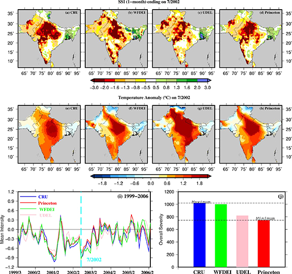
Figure 1. The worst drought (the year 1999–2006) using 1 month SSI from CRU, Princeton, UDEL, and WFDEI dataset. (a)–(d) Drought condition at the end of July 2002 using 1 month SSI data from CRU, WFDEI, UDEL, and Princeton datasets. (e)–(h) Temperature anomaly (°C) in July 2002 using mean temperature from CRU, WFDEI, UDEL, and Princeton. The temperature anomaly was estimated against the reference period 1951–2016. (i) Area averaged drought intensity during the most severe drought spell (1999–2006) using 1 month SSI from CRU, WFDEI, UDEL, and Princeton datasets. (j) Overall severity score (mean intensity × area × duration) of the worst drought spell (1999–2006) in CRU (maximum; 1019), WFDEI, UDEL, and Princeton (minimum; 746).
Download figure:
Standard image High-resolution imageTable 1. Drought spells estimated using the 1 month SSI from CRU, Princeton, UDEL, and WFDEI during the period 1951–2016. The bold number shows consistent drought spells in all four datasets.
| CRU | |||||||||
|---|---|---|---|---|---|---|---|---|---|
| Year | Month | Year | Month | Max Area | Mean area | Duration | Max intensity | Mean intensity | Overall severity |
| 1951 | 7 | 1953 | 6 | 69.91 | 49.65 | 24 | −0.73 | −0.38 | 447.25 |
| 1957 | 9 | 1958 | 7 | 64.67 | 47.87 | 11 | −0.71 | −0.27 | 143.24 |
| 1960 | 8 | 1961 | 5 | 41.89 | 33.36 | 10 | −0.32 | −0.10 | 31.69 |
| 1964 | 11 | 1967 | 11 | 75.52 | 41.39 | 37 | −0.82 | −0.21 | 327.74 |
| 1968 | 5 | 1970 | 5 | 75.58 | 46.84 | 25 | −0.82 | −0.31 | 366.25 |
| 1972 | 1 | 1973 | 7 | 74.32 | 51.80 | 19 | −0.90 | −0.46 | 455.24 |
| 1974 | 6 | 1975 | 5 | 54.57 | 40.69 | 12 | −0.58 | −0.24 | 117.42 |
| 1984 | 10 | 1988 | 6 | 61.83 | 39.83 | 45 | −0.68 | −0.18 | 320.87 |
| 1991 | 7 | 1994 | 6 | 59.62 | 36.28 | 36 | −0.79 | −0.15 | 190.40 |
| 1999 | 12 | 2006 | 2 | 80.82 | 45.90 | 75 | −1.03 | −0.30 | 1019.47 |
| 2008 | 10 | 2010 | 7 | 57.73 | 45.19 | 22 | −0.80 | −0.29 | 290.68 |
| 2011 | 10 | 2013 | 1 | 62.71 | 40.50 | 16 | −0.71 | −0.25 | 161.37 |
| 2014 | 6 | 2015 | 2 | 72.05 | 54.13 | 9 | −1.05 | −0.62 | 300.39 |
| 2015 | 9 | 2016 | 12 | 67.63 | 49.25 | 16 | −0.70 | −0.35 | 276.70 |
| Princeton | |||||||||
| 1951 | 7 | 1953 | 7 | 61.07 | 44.13 | 25 | −0.57 | −0.25 | 275.35 |
| 1957 | 9 | 1958 | 7 | 58.93 | 42.61 | 11 | −0.60 | −0.17 | 80.48 |
| 1960 | 8 | 1961 | 4 | 37.03 | 31.51 | 9 | −0.20 | −0.01 | 4.21 |
| 1964 | 12 | 1967 | 11 | 64.79 | 41.67 | 36 | −0.63 | −0.19 | 288.42 |
| 1968 | 5 | 1969 | 12 | 63.03 | 45.31 | 20 | −0.68 | −0.28 | 251.00 |
| 1972 | 3 | 1973 | 5 | 64.48 | 47.60 | 15 | −0.73 | −0.36 | 253.73 |
| 1974 | 11 | 1975 | 5 | 40.32 | 36.76 | 7 | −0.17 | −0.11 | 27.11 |
| 1984 | 5 | 1985 | 9 | 54.32 | 39.55 | 17 | −0.46 | −0.19 | 128.29 |
| 1987 | 6 | 1988 | 5 | 57.10 | 47.16 | 12 | −0.54 | −0.29 | 162.81 |
| 1991 | 7 | 1993 | 1 | 53.69 | 38.59 | 19 | −0.62 | −0.12 | 87.51 |
| 1999 | 12 | 2003 | 6 | 76.40 | 48.40 | 43 | −0.87 | −0.36 | 746.54 |
| 2008 | 10 | 2010 | 5 | 51.92 | 43.37 | 20 | −0.59 | −0.23 | 196.82 |
| 2012 | 2 | 2012 | 8 | 52.62 | 41.42 | 7 | −0.53 | −0.28 | 82.03 |
| 2014 | 6 | 2015 | 2 | 66.31 | 47.57 | 9 | −0.91 | −0.44 | 189.31 |
| 2015 | 9 | 2016 | 12 | 57.67 | 37.16 | 16 | −0.43 | −0.13 | 78.35 |
| UDEL | |||||||||
| 1951 | 7 | 1953 | 6 | 61.83 | 48.92 | 24 | −0.65 | −0.40 | 464.75 |
| 1954 | 3 | 1955 | 7 | 45.74 | 35.06 | 17 | −0.38 | −0.14 | 84.57 |
| 1957 | 9 | 1958 | 7 | 55.27 | 46.77 | 11 | −0.54 | −0.31 | 157.61 |
| 1960 | 8 | 1961 | 5 | 44.79 | 35.96 | 10 | −0.34 | −0.14 | 51.68 |
| 1962 | 5 | 1964 | 6 | 57.67 | 38.23 | 26 | −0.52 | −0.16 | 155.83 |
| 1964 | 11 | 1967 | 11 | 71.36 | 46.07 | 37 | −0.76 | −0.34 | 587.06 |
| 1968 | 5 | 1971 | 4 | 67.44 | 42.48 | 36 | −0.75 | −0.27 | 405.98 |
| 1972 | 1 | 1973 | 7 | 65.99 | 46.95 | 19 | −0.78 | −0.40 | 356.33 |
| 1974 | 2 | 1975 | 6 | 58.11 | 39.72 | 17 | −0.58 | −0.21 | 143.10 |
| 1984 | 10 | 1988 | 6 | 57.79 | 41.32 | 45 | −0.64 | −0.20 | 372.71 |
| 1991 | 7 | 1993 | 9 | 54.70 | 36.66 | 27 | −0.73 | −0.19 | 188.75 |
| 1999 | 3 | 2005 | 8 | 71.61 | 41.28 | 78 | −0.81 | −0.25 | 818.81 |
| 2007 | 11 | 2008 | 5 | 38.99 | 34.53 | 7 | −0.19 | −0.02 | 5.28 |
| 2008 | 10 | 2010 | 5 | 54.13 | 40.08 | 20 | −0.53 | −0.21 | 164.63 |
| WFDEL | |||||||||
| 1951 | 6 | 1955 | 7 | 69.34 | 42.54 | 50 | −0.65 | −0.23 | 482.56 |
| 1957 | 8 | 1958 | 7 | 68.01 | 47.49 | 12 | −0.74 | −0.29 | 162.61 |
| 1960 | 8 | 1961 | 5 | 44.86 | 33.34 | 10 | −0.41 | −0.05 | 18.26 |
| 1964 | 11 | 1967 | 11 | 73.94 | 44.91 | 37 | −0.79 | −0.28 | 462.95 |
| 1968 | 6 | 1970 | 5 | 67.38 | 44.78 | 24 | −0.81 | −0.24 | 258.17 |
| 1972 | 3 | 1973 | 6 | 64.79 | 49.96 | 16 | −0.72 | −0.37 | 296.44 |
| 1974 | 6 | 1975 | 6 | 60.25 | 40.26 | 13 | −0.67 | −0.18 | 92.86 |
| 1980 | 8 | 1981 | 10 | 50.16 | 35.13 | 15 | −0.38 | −0.10 | 53.65 |
| 1982 | 7 | 1983 | 6 | 59.94 | 39.79 | 12 | −0.63 | −0.04 | 21.19 |
| 1984 | 7 | 1988 | 6 | 62.59 | 44.72 | 48 | −0.69 | −0.23 | 504.31 |
| 1989 | 2 | 1990 | 1 | 48.26 | 35.66 | 12 | −0.37 | −0.11 | 48.20 |
| 1991 | 7 | 1992 | 7 | 63.41 | 50.77 | 13 | −0.56 | −0.34 | 224.81 |
| 1999 | 12 | 2005 | 1 | 80.06 | 48.09 | 62 | −0.97 | −0.34 | 1000.46 |
| 2007 | 11 | 2008 | 5 | 40.50 | 33.70 | 7 | −0.20 | −0.01 | 3.33 |
| 2009 | 1 | 2010 | 7 | 57.92 | 45.63 | 19 | −0.73 | −0.27 | 231.28 |
| 2012 | 2 | 2013 | 3 | 65.05 | 40.80 | 14 | −0.77 | −0.27 | 154.46 |
| 2015 | 9 | 2016 | 12 | 60.69 | 43.59 | 16 | −0.51 | −0.23 | 163.30 |
We find that the 2002 drought affected the central parts of South Asia more severely in all the four datasets (figure 1), which is the major agricultural region in South Asia and may be affected the food and agricultural productivity in the region. Therefore, to evaluate the impact of drought on crop yield, we estimated the first difference of rice yield (Lobell and Field 2007, Mishra et al 2020) for India, Pakistan, Bhutan, Bangladesh, Nepal, and Sri Lanka (figure S5). The 2002 drought resulted in a considerable reduction in rice yield in India, Nepal, and Sri-Lanka (figure S5). For instance, rice yield was decreased by 470 kg ha−1 in India in 2002 due to the severe drought condition, which was the highest reduction in yield during the 1961–2016 period. Moreover, we find an increase in rice yield in Bhutan and Bangladesh in 2002, which can be attributed to wet soil moisture conditions in the Northeast region (figure 1). We also estimated the NDVI anomaly for the 2002 drought during the monsoon season (June–September) over South Asia (figure S5), which indicates a considerable decline in NDVI in the northwestern parts of South Asia. However, the positive NDVI anomalies in Indo-Gangetic plains are associated with groundwater irrigation and human activities. The results of 2002 drought impact on agricultural productivity are consistent with the previous studies (Mishra et al 2014, 2020, Aadhar and Mishra 2017). The decline in the agricultural yield in 2002 was also associated with the concurrent hot and dry conditions (Mishra et al 2020). The droughts during the monsoon season in South Asia often overlap with positive air temperature anomalies (Mishra et al 2020). Therefore, we estimated temperature anomaly for the year 2002 over South Asia using the mean air temperature from CRU, WFDEI, UDEL, and Princeton (figure 1). We find that the temperature anomaly in July 2002 was significantly high (∼2 °C) in the parts of South Asia, which can be partly attributed by depletion of soil-moisture due to land–atmospheric interaction (Fischer et al 2007, Miralles et al 2014, Horton et al 2016) (figure 1). Central India experienced a temperature anomaly of more than 2 °C during July 2002 in all the four datasets (figure 1), which might have exacerbated soil moisture deficit and water availability in South Asia.
All the four datasets captured the soil moisture drought and associated temperature anomalies during 2002 over South Asia (figure 1). However, soil moisture droughts based on the four observed datasets show considerable uncertainty in their characteristics (intensity, area, duration, and severity) (figures 1, S3 and S4), which highlights the need of considering different observational products for the drought assessment. For instance, the 2002 drought was the worst drought in CRU, WFDEI, UDEL, and Princeton, however, with the overall severity scores of 1019, 1000, 818, and 746, respectively (figure 1). Moreover, the intensity, duration, and areal coverage of the 2002 drought exhibited a large uncertainty (figures 1 and S4, table 1). For instance, the duration of the 2002 drought varies between 43 and 78 months in all the four datasets (table 1). Similar to the 2002 drought, the four datasets showed considerable uncertainty in the other drought spells and their characteristics during 1951–2016 (table 1). We identified 17 drought spells using 1 month SSI based on WFDEI data during 1951–2016. However, only 14 drought spells were identified using SSI based on the CRU and UDEL datasets during the same period. The difference in the drought spells was mainly due to uncertainty in the area average drought intensity in all the four datasets.
We find a large uncertainty in the area under drought based on 1 month SSI obtained using the VIC model simulations using the four datasets (figure S4). The uncertainty in drought characteristics and spells can be attributed to the difference in the precipitation and temperature in the four different global datasets (figure S6). For instance, all the four datasets showed a considerable variation in mean annual precipitation and temperature, which translates into soil moisture simulations from the VIC model (figure S6). Despite the large variation among the four datasets, we find a total of 11 drought spells (1952–1955, 1957–1958, 1960–1961, 1965–1967, 1968–1970, 1972–1973, 1974–1975, 1984–1988, 1991–1994, 1999–2006, and 2008–2010), which were consistent in all the four datasets (CRU, Princeton, UDEL, and WFDEI) (table 1, figure S3). These 11 drought spells based on monthly SSI also exhibit uncertainty in the associated drought characteristics (figures S3 and S4, table 1). Our results show that more attention is required in the identification of droughts. For instance, there is considerable uncertainty in soil moisture droughts and associated characteristics based on the four observational datasets in South Asia. Nonetheless, the 2002 drought was the worst drought that affected more than 60% of South Asia and had severe implications for food production and water availability in the region.
3.2. Occurrence of observed severe droughts in the future climate
Since the 2002 drought was the worst drought with considerable implications in South Asia, it is imperative to examine the risk of such drought under the warming climate in the future. We conducted simulations using the VIC model and meteorological forcing from 40 members of CESM-LENS data for the historical (1951–2016) and future (2035–2100) period. The CESM-LENS simulations have an advantage as these are available for a large-ensemble and simulate the summer monsoon variability reasonably well (Mishra et al 2020). In addition, simulations based on the CESM-LENS forcing can be useful to estimate the occurrence of rare events such as the worst drought of 2002 during the observed climate. A large number of CESM-LENS data (2640 years for each period) provides an opportunity to perform a robust analysis on the occurrence of worst droughts in the historical and future periods over South Asia. We considered the overall severity score from all four datasets (as a threshold; THCRU, THWFDEI, THUDEL, and THPrinceton) to estimate the occurrence of the 2002 drought under the warming climate. We estimated the major drought spells in each member of CESM-LENS data using 1 month SSI based on the VIC model-simulated soil moisture.
We identified all the drought spells in the CESM-LENS that had the overall severity score higher than the thresholds for the 2002 drought in the observed climate. For instance, we identified all the drought spells in CESM-LENS that exceeded the overall severity score of 1019 to understand the risk of the occurrence of the worst drought based on the threshold of the CRU data (table S1). Since the risk of occurrence of worst drought in CESM-LENS varies with the threshold of an overall severity score based on the four observational products, we considered the uncertainty of observations to identify the worst droughts in CESM-LENS (THCRU, THWFDEI, THUDEL, and THPrinceton; table S1). We estimated the frequency of the worst drought in the historical (1951–2016) and future (2035–2100) period in 40-members of CESM-LENS using overall severity score from CRU (THCRU), WFDEI (THWFDEI), UDEL (THUDEL), and Princeton (THPrinceton) (table S1). We estimated the occurrence of worst droughts per 100 years in the historical and future periods using the frequency droughts spells that exceeded the thresholds of the worst observed drought based on the four datasets (CRU, UDEL, WFDEI, and Princeton) (figure 2). The occurrence of the worst drought per 100 years was estimated using the number of worst droughts in the CESM-LENS multiplied by 100 and divided by the total number of years (40 × 66 = 2640 years) in the historical and future climate (table S1).
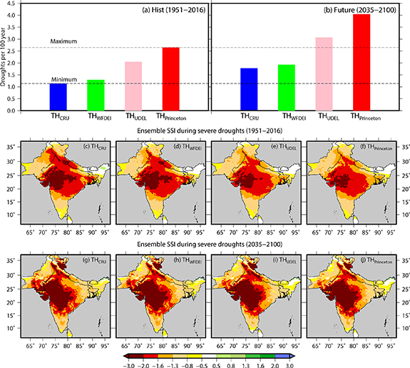
Figure 2. The occurrence of the worst droughts in historical and future climate using the CESM-LENS meteorological forcing for the VIC model simulations. (a), (b) The frequency/100 year of the worst drought (overall severity more than the year 2002 drought) in the historical (1951–2016) and future (2035–2100) period using 40-members of CESM-LENS. The frequency was estimated using the number of droughts that exceeded the overall severity score of the worst drought that occurred during the selected period (historical or future) divided by the total number of years in the period in 40-members of CESM-LENS. The ensemble mean of 1 month SSI for the worst drought (during the peak) occurred during the (c)–(f) historical and (g)–(j) future period. The droughts, which had severity more than the 2002 drought in CRU, WFDEI, UDEL, and Princeton, are considered as severe droughts.
Download figure:
Standard image High-resolution imageThe frequency of occurrence of the worst droughts per 100 years varied from 1.1 to 2.6 during the historical period of CESM-LENS (1951–2016). The occurrence of the worst drought in CESM-LENS exceeding THCRU had the lowest (1.1 events in 100 years on average) frequency of occurrence in 100 years due to the highest overall severity score of the 2002 drought. We find a lesser number of droughts exceeding THCRU in comparison to the WFDEI, UDEL, and Princeton datasets. Since the overall severity score of Princeton data was lowest (THPrinceton; table S1), the highest frequency of occurrence (2.6) per 100 years was identified in the historical period. Therefore, the risk of the worst drought in the historical period of CESM-LENS is more than two-fold in the Princeton data in comparison to the risk based on the CRU dataset. Our results show the need of the identification of the occurrence of the worst drought based on the different observational datasets.
The uncertainty in the occurrence of the worst drought can have implications for the planning of water resources structures. Moreover, as the frequency of the worst drought is higher based on the Princeton data (table S1), lower risk in the historical and future periods were found in comparison to the other observational datasets. Similar to the historical period (1951–2016), we estimated the frequency of occurrence of the worst drought (like 2002) in the future (2035–2100) period in CESM-LENS simulations (table S1, figure 2). We find that the frequency of the worst drought is projected to increase in the period 2035–2100 in CESM-LENS based on the thresholds of all the four datasets. Therefore, droughts like 2002 may occur more frequently in the projected future climate in South Asia. We find a similar increase in the occurrence of droughts per 100 years in the future climate for all the four thresholds based on the four observational products. The frequency of the worst drought during the future climate varies between 1.7 and 4 droughts in 100 years based on the four observational datasets. Therefore, the occurrence of the worst drought per 100 years is projected to increase by 1.5-times (1.17–1.7 in THCRU; 1.29–1.93 in THWFDEI; 2–3 in THUDEL; and 2.6–4 in THPrinceton) in the future (2035–2100) in comparison to the historical period. Other than the identification of the worst drought based on the observed overall severity score, we estimated the frequency of the longest and the most widespread drought (considering the 1999–2006 drought spell as a benchmark) in the historical (1951–2016) and future (2035–2100) periods. We find that the frequency of widespread droughts is projected to increase in the future (table S2), while the frequency of prolonged droughts is projected to decrease in the future climate (table S3).
Next, we estimated the ensemble mean of SSI based on the VIC model simulations using CESM-LENS forcing for all the droughts that exceeded the overall severity score of the worst drought based on the four observational datasets (table S1) for the historical (1951–2016) and the future (2035–2100) periods (figure 2). To construct the ensemble mean of all the worst drought identified during the historical and future periods, we considered peak intensity of drought spells (figures 2 and S6). We find that the ensemble mean of SSI for the worst droughts occurred in the historical climate of CESM-LENS showed exceptional drought (SSI < −2) condition over the central and western parts of South Asia in the ensembles based on all four thresholds (THCRU, THWFDEI, THUDEL, and THPrinceton) (figures 2(c)–(f)). Moreover, the majority of South Asia was affected by the droughts that exceeded the overall severity of the worst drought (figures 2(c)–(f)). As expected, the ensemble mean of the worst droughts based on THCRU showed higher drought intensity in comparison to the other three (THWFDEI, THUDEL, and THPrinceton) as THCRU was the highest.
Similar to the historical period of CESM-LENS, we constructed an ensemble mean of all the droughts that exceeded the overall severity score of the four observational datasets in the future climate (figures 2(g)–(j)). We find that the ensemble mean of droughts that exceeded the threshold of the worst drought (like 2002) show an exceptional drought condition over the central and western parts of South Asia (figures 2(g)–(j)). The area under the exceptional drought condition (SSI < −2) is higher in the ensemble mean of the worst droughts in the future in comparison to the historical period (figure 2). Moreover, our results show that future drought spells are projected to be more severe, intense, and widespread in South Asia (figures 3(a) and S7, table S2). To examine the temperature anomalies associated with the worst droughts in South Asia, we constructed the ensemble mean of temperature anomalies during the peak drought intensity in the historical and future periods (figure S8). We find that the temperature anomalies exceed 2 °C–3 °C during the worst droughts that were identified in the historical climate based on the CESM-LENS simulations. Moreover, air temperature anomalies associated with the worst droughts in the future can reach to 6 °C–7 °C (figure S8). This substantial rise in temperature during the worst droughts can be detrimental to the agricultural production and water resources in the region. In addition, the concurrent soil moisture drought and high temperature can be lead to heat waves and heat stress in the region (Mishra et al 2017, Nanditha et al 2020). Our results support the previous findings showing the increase in the monsoon and annual drought frequency in the future climate over South Asia (Aadhar and Mishra 2018, 2020, Mishra et al 2020). Overall, we find that the frequency of the worst droughts (like 2002) is projected to rise in the future climate. In addition, the worst droughts in the future are projected to be more severe, intense, and widespread in South Asia.
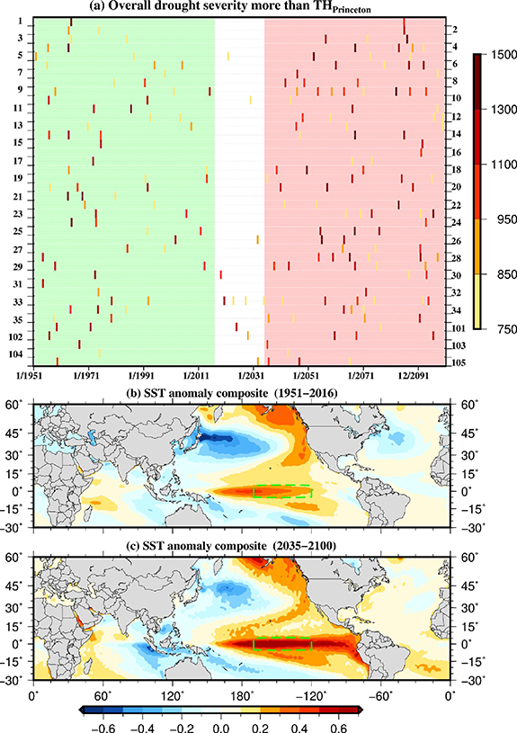
Figure 3. The occurrence of the worst droughts and respective SST anomaly composite in the CESM-LENS data. (a) The occurrence of the worst droughts [overall severity more than THPrinceton (Overall severity of the year 2002 drought in Princeton)] during the period 1951–2100 in the 40-ensemble member of CESM-LENS. Light green and pink shaded areas represent the historical (1951–2016) and future (2035–2100) period. The color scale in (a) shows the overall severity score (intensity × area × duration). (b) and (c) Monsoon season (JJAS) SST anomaly composite during the worst droughts in the historical and future periods. The green box in (b) and (c) shows the Nino 3.4 region.
Download figure:
Standard image High-resolution image3.3. Role of ENSO
Next, we estimated the linkage between the sea surface temperature (SST) and the worst droughts (overall severity score more than THPrinceton; in figure 4(a)) that occurred in the historical and future climate in South Asia using CESM-LENS simulations. We selected the overall severity score threshold of the Princeton data as it was the lowest among all the four datasets. Therefore, the droughts that exceed THPrinceton will also exceed the thresholds of the other three datasets (CRU, UDEL, and WFDEI). All the droughts that exceeded the threshold of the overall severity score (THPrinceton) were identified during the historical and future periods in all the 40 ensemble members of CESM-LENS (figure 3(a)). It is evident that there are several droughts that exceeded the overall severity score (1019) of the worst drought identified using the soil moisture simulations based on the CRU data.

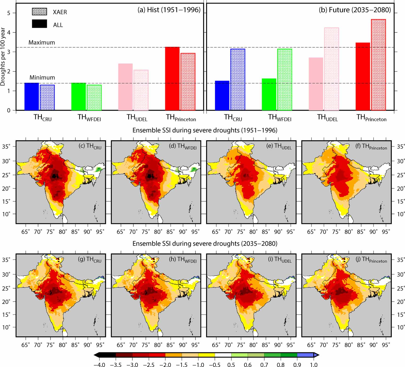
Figure 4. The occurrence of the worst droughts during the fixed industrial aerosol (XAER) condition. (a) and (b) Frequency (per 100 year) of the worst drought (overall severity more than the year 2002 drought) during the ALL and XAER scenarios for the historical (1951–1996) and future (2035–2080) using 20-members of CESM-LENS data. The frequency was estimated using the number of worst droughts that occurred in the selected period divided by the total number of years in the period in 20-members of CESM-LENS. (c)–(j) The ensemble mean of 1 month SSI for severe drought occurred during the (c)–(f) period 1951–1996 and (g)–(j) 2035–2080. The droughts, which have severity more than the 2002 drought in CRU, WFDEI, UDEL, and Princeton, are considered as the worst droughts.
Download figure:
Standard image High-resolution imageSince SST from CEMS-LENS shows a strong trend in the warming climate, we used the ensemble empirical mode decomposition method (Wu and Huang 2009) to remove the time-varying secular trend (Wu et al 2011) from the SST data. After removing the trend from SST, we constructed the monsoon (June to September) season SST anomaly composite for the all droughts that exceeded the threshold (THPrinceton) during the historical (1951–2016) and future (2035–2100) periods. We find that the worst droughts occurred in South Asia are associated with the warm SST anomalies over the central Pacific Ocean (5° N–5° S, 170° W–120° W; Nino 3.4 region) in the historical and future periods (figures 3(b) and (c)), which is consistent with the observations (Mishra et al 2012, 2020, Roxy et al 2015). Moreover, we estimated the contribution of Nino 3.4 in the occurrence of the worst droughts during the historical and future periods (table S4). We find that more than 90% of the worst droughts are associated with the warm SST over Nino 3.4 region in the historical period (1951–2016) based on the CESM-LENS simulations. In the future period (2035–2100), about 80% of the worst droughts associated with warm SST anomalies showing that SST anomalies over Nino 3.4 during the monsoon season will continue to play an essential role in the future droughts. Overall, our results show that warm SST anomaly over Nino 3.4 is the primary driver of the worst droughts over South Asia.
3.4. Role of anthropogenic activities in the occurrence of severe droughts
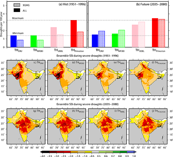
Our results show that the worst droughts (like the year 2002) are projected to become more frequent (1.5 times) in the future climate with an increased drought intensity and areal coverage. However, it remains unclear that to what extent do the anthropogenic activities (greenhouse-gas emission and industrial aerosol) affect the occurrence of these major soil moisture droughts in South Asia. To examine the role of anthropogenic activities (greenhouse gas emission and industrial aerosol) in the occurrence of the droughts that exceeded the overall severity score of the worst drought of the observed climate, we used 'All-but-one-forcing-fixed' CESM-LENS experiments. The 'ALL-but-one-forcing-fixed' experiments used the same simulation protocol as CESM-LENS, except that one forcing agent (XGHG or XAER) is held fixed at 1920 conditions (Deser et al 2020b). We estimated the drought spells in the fixed industrial aerosol (XAER) and XGHG conditions and compared them with the ALL (natural + anthropogenic) scenario of the CESM-LENS simulations. We conducted soil moisture simulations using the VIC model for XGHG and XAER scenarios for the historical and future periods for the 20 ensemble members of CESM-LENS. Therefore, the role of GHG/AER emissions on droughts can be identified by comparing the ALL and XGHG/XAER simulations.
The frequency of droughts that exceeded the overall severity score of the worst drought (like 2002) was estimated in the ALL and XAER scenarios using 20-members of CESM-LENS for the historical (1951–1996) and future (2035–2080) (figure 4, table S5). We find that the frequency (per 100 years) of worst droughts in the ALL and XAER are similar during the historical climate for all four thresholds (THCRU, THWFDEI, THUDEL, and THPrinceton), indicating that there is no effect of aerosols on the occurrence of worst drought during the historical period of CESM-LENS. However, the frequency of the worst droughts in the future (2035–2080) is higher in the XAER in comparison to the ALL (natural + anthropogenic) scenario, indicating that the region could have faced more droughts in the future (2035–2080) in the absence of industrial aerosols. We find that the ensemble mean of SSI for the droughts that exceeded the overall severity score of the worst drought (2002) showed an exceptional drought condition (SSI < −2) and a large areal coverage during the historical and future climate (figure 4). However, the ensemble mean SSI of worst droughts occurred in future is less severe than the ensemble mean SSI of worst droughts occurred in the historical period over South India (figure 4). The decrease in the ensemble mean severity of worst droughts in South India in the future under the XAER scenario can be attributed to an increase in precipitation in the region (figure S9). Temperature anomalies of 2 °C–3 °C and 4 °C–6 °C were associated with the worst droughts in the historical and future periods, respectively (figure S10). Overall, we find that without industrial aerosol emissions, the frequency of the worst droughts in the future can be higher in comparison to the ALL scenario in South Asia. The XAER induced high temperature and results increase in heat extremes (Horton et al 2016, Xu et al 2018). Therefore, the increased atmospheric aridity and frequent heat extremes in XAER scenario result higher frequency of worst droughts in the XAER scenario.
Finally, to estimate the role of greenhouse gas (GHG) emissions on the occurrence of the worst droughts in South Asia, we estimated the frequency of droughts that exceeded the overall severity score of the four datasets (THCRU, THWFDEI, THUDEL, and THPrinceton) (figure 5, table S5). For the XGHG condition, we find that the smaller number of worst droughts occurred during the historical climate in comparison to the ALL scenario. Moreover, the frequency of the worst droughts in the XGHG and ALL are similar in the future (2035–2080) climate. Since GHG emission is the primary source of atmospheric warming, we find a relatively lesser increase in the temperature over South Asia in the future climate in XGHG condition (figures S9 and S11). The lesser projected rise in temperature under the future climate in XGHG does not accelerate the soil-moisture depletion during the post-monsoon season despite a decline in the summer monsoon precipitation. Moreover, the soil-moisture during the post-monsoon season recovers after moderate rainfall and avoids the long-lasting worst droughts in the future climate under XGHG scenario. Therefore, the lesser rise in temperature does not cause an increase in the frequency of the worst droughts despite a projected decrease in summer monsoon precipitation in the future (figure S9). In addition, we find that the ensemble mean of SSI of the worst droughts is higher in the future compared to the historical period (figure 7). The higher ensemble mean SSI in the future may be associated with the consecutive failure of monsoon seasons or large deficit in precipitation over South Asia (figure S9). Overall, our results show that the frequency of worst droughts remains the same in the future climate in without greenhouse gas emission scenario compared to ALL scenario.
Figure 5. The occurrence of the worst droughts during the fixed greenhouse gas emission (XGHG) condition. (a), (b) The frequency of occurrence of the worst drought (overall severity more than the year 2002 drought) during the ALL and XGHG scenarios for the historical (1951–1996) and future (2035–2080) periods using 20-members of CESM-LENS. The frequency was estimated using the number of worst droughts that occurred in a period divided by the total number of years in the period in 20-members of CESM-LENS. (c)–(j) The ensemble mean of 1 month SSI for the worst drought occurred during the (c)–(f) period 1951–1996 and (g)–(j) 2035–2080. The droughts, which have severity more than the 2002 drought in CRU, WFDEI, UDEL, and Princeton, are considered as the worst droughts.
Download figure:
Standard image High-resolution image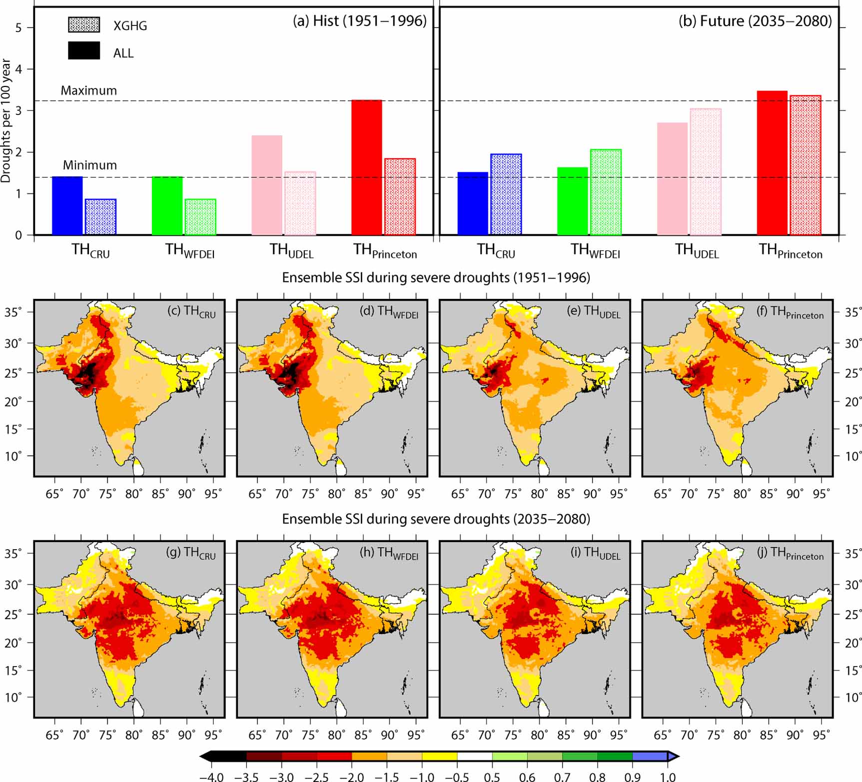
4. Discussion
The weakening of the summer monsoon and frequent droughts affected the surface and groundwater resources (Mishra et al 2016, Asoka et al 2017), agricultural production (Mishra et al 2019, 2020), and economic growth (Gadgil and Gadgil 2006) over South Asia in the past. We examined the occurrence of soil moisture drought over South Asia during the 1951–2016 period. Considering the observational uncertainty, droughts were identified using 1 month SSI based on the VIC model simulations using the four observational datasets (CRU, Princeton, UDEL, and WFDEI). We identified major drought spells using soil moisture simulations based on the four products. Our results showed that there is considerable uncertainty in the number of drought spells and the characteristics (intensity, duration, and frequency) of individual droughts. This uncertainty in the droughts is associated with the inconsistency in the meteorological forcing (precipitation, temperature, and wind) data. There are many sources that can result in uncertainty in the observed meteorological forcing (McMillan et al 2011). The inadequacy of gauge stations in an area and assumptions made during the interpolation of gauge station data (Moulin et al 2009, Refsgaard et al 2006, Villarini et al 2008) can cause considerable uncertainty. In addition, uncertainty in the observed datasets can be introduced due to systematic and random errors associated with the measurements (Molini et al 2001, McMillan et al 2011).
Uncertainty in the meteorological forcing is propagated to the soil moisture simulations obtained from the VIC model. Our results showed that the worst drought (2002 drought) has substantial uncertainty in severity, duration, and area under drought in South Asia. The uncertainty in the severity, duration, and area of the worst drought can affect the planning of water resources and assessment of the impact of drought in the region. For instance, considering only the Princeton forcing that showed the lowest overall severity among the four datasets, the drought risk can be underestimated. Therefore, we need to consider the uncertainty of observed datasets in the drought assessment under the observed and future climate in South Asia. Similar to the uncertainty in the observed datasets, the selection of the hydrological model and parameters can also show the uncertainty in the estimation of drought characteristics (Samaniego et al 2013, Mishra et al 2018).
We find that the occurrence of the worst drought is projected to increase in the future period (2035–2100) with higher drought intensity and areal-extent. Our results are consistent with the previous studies that showed the increase in the frequency of annual drought (Aadhar and Mishra 2020) and concurrent hot-dry extreme events during the monsoon season (Mishra et al 2020). The increase in the frequency of worst drought in the future climate is mainly attributed to the increase in the atmospheric water demand (Scheff and Frierson 2014, Mishra et al 2020). Further, we identified the role of anthropogenic activities (greenhouse gas emission and industrial aerosol) in the occurrence of worst droughts in the future climate. The occurrence of worst droughts is higher in the future in XAER emission scenario compared to ALL (natural + anthropogenic) in South Asia. However, the occurrence of worst droughts is similar to the ALL and XGHG scenarios in the future. Our analysis shows that fixed industrial aerosol (XAER) causes increased temperature in the atmosphere and leads to an increase in heat extremes (Horton et al 2016, Xu et al 2018) and worst droughts in the future climate. Moreover, the increase in the monsoon season precipitation in XAER scenario is associated with increased greenhouse gas emission and global warming (Wu et al 2013, Pascale et al 2016). However, the XGHG scenario projects a decline in precipitation in the future period. Despite the decreasing precipitation in the future period in XGHG, we find a similar frequency of worst droughts as in the ALL and XGHG, which can be attributed to a decline in temperature under the XGHG.
Our study suggests that worst droughts are projected to increase in the future climate with increased intensity and a larger areal extent. Since the worst droughts (like the 2000 drought) pose a severe impact on water storage and agriculture in the South Asian region (Zampieri et al 2018, Shah and Mishra 2020b), our analysis can be used for water management planning and policy-making in the future climate. We need to consider the increased frequency of the worst droughts under the future climate for the planning of adaptation and mitigation in South Asia.
5. Conclusions
Based on our findings, the following conclusions can be made:
- Soil moisture droughts were identified using the VIC model simulations for the four observational datasets during the 1951–2016 period in South Asia. The worst soil moisture drought occurred during 1999–2006 in South Asia based on the four global datasets (CRU, Princeton, UDEL, WFDEI).
- A considerable uncertainty in the drought spells and their characteristics was found based on the four observational datasets. The worst drought of 2002 showed a substantial uncertainty in the intensity, area, duration, and severity of drought over South Asia in four (CRU, Princeton, UDEL, WFDEI) datasets.
- The occurrence of the worst drought (like 1999–2006 drought) is projected to increase by 1.5-times in the future climate (2035–2100) based on all four thresholds (THCRU, THWFDEI, THUDEL, and THPrinceton). Moreover, the worst drought spells are projected to be more severe, intense, and widespread in South Asia under the warming climate. More than 80% of the worst droughts in the future are associated with El Nino during the monsoon season.
- Our results show that industrial aerosol plays an important role in the occurrence of worst droughts in future climate than the greenhouse gas emission. Without industrial aerosol emissions, the frequency of the worst droughts can be higher in comparison to the ALL scenario (natural + anthropogenic) over South Asia in the future climate. However, the occurrence of worst droughts remains the same in without greenhouse gas emission scenario in comparison to the ALL scenario, which can be attributed to the combined effect of change in precipitation and temperature.
Acknowledgments
We acknowledge all data sources (CRU, UDEL, WFDEI, Sheffield data from Princeton University, and CESM-LENS) for providing the precipitation, temperature, and wind datasets. The first author appreciates financial assistance from the Indian Ministry of Human Resource Development (MHRD). The study is partially funded by the Ministry of Earth Sciences and the Ministry of Water Resources forum projects.
Data availability statement
The data that support the findings of this study are available upon reasonable request from the authors.