


Abstract
It has been predicted that high equatorial temperatures on Mercury could promote thermal annealing by Ostwald ripening, where nanophase metal particles (a product of space weathering) coalesce and grow into larger, microphase particles, resulting in lower albedo. Here, we test this prediction by studying the correlation between albedo and temperature in 1° spatial bins using newly recalibrated 1064 nm reflectance data acquired by the Mercury Laser Altimeter (MLA), low incidence angle data from the Mercury Dual Imaging System (MDIS), and newly modeled maximum surface temperatures (MSTs). Accounting for local geology and latitude, we compare the reflectance values of surfaces with MSTs >675 K (where Ostwald ripening is predicted to be most effective) to surfaces with MSTs <473 K (where ripening is predicted not to be effective). Smooth plain surfaces >675 K are 10% and 12% darker than surfaces <473 K in MLA and MDIS data, respectively, and nonsmooth plain surfaces >675 K are 8% and 7% darker than surfaces <473 K. However, open questions remain regarding the causation of this darkening; statistical tests cannot distinguish whether the reflectance differences are systematic or the result of compositional variations that happen to correlate with MST. Along Mercury's thermal longitudes, we find that reflectance is typically lower along hot poles than along the 90°E cold pole in the low-to-midlatitudes, especially in the smooth plains, consistent with previous work identifying a decrease in optical maturity along the 90°E cold pole. Longitudinal reflectance variations correlate with temperature variations, rather than variations in micrometeoroid or solar wind fluxes.
Export citation and abstract BibTeX RIS

Original content from this work may be used under the terms of the Creative Commons Attribution 4.0 licence. Any further distribution of this work must maintain attribution to the author(s) and the title of the work, journal citation and DOI.
1. Introduction
Space weathering broadly refers to the physical and chemical alteration of surface materials on airless bodies, which can result from exposure to small impacts and irradiation by electromagnetic radiation or by atomic particles from solar or galactic sources (e.g., Pieters et al. 2000, 2012; Hapke 2001; Pieters & Noble 2016; Clark et al. 2023). At the visible (VIS) to near-infrared (NIR) wavelengths, space weathering can result in the darkening of the optical surface (i.e., a decrease in albedo), a reduction in spectral contrast, and a reddening of the absorption spectrum (e.g., McCord & Adams 1972; Fischer & Pieters 1995), and the magnitude of these changes is wavelength-dependent (Keller et al. 1998; Noble et al. 2007; Lucey & Noble 2008). These changes are driven by some combination of the accumulation of nanophase iron (npFe0; e.g., Hapke 2001; Sasaki et al. 2001; Noble et al. 2007), the formation of impact glasses and agglutinates (e.g., Adams & McCord 1971), and the physical fragmentation of regolith into finer particles (e.g., Pieters et al. 1993). The rate at which a surface is space-weathered depends not only on the intensity of the operating space-weathering processes (e.g., Hapke 2001; Hemingway et al. 2015; Sim et al. 2017) but also on various characteristics of the surface target, including its age, composition, level of hydration, grain-size distribution, and thermal profile (e.g., DesMarais et al. 1974; Hapke 1981, 1984, 1986, 1993, 2002, 2012; Pieters et al. 1993; Lucey et al. 1998, 2002; Moroz et al. 2000; Milliken & Mustard 2007; Domingue et al. 2014; Deutsch et al. 2020; Trang et al. 2021). Additionally, the rate of accumulation of space-weathering products is in competition with rates of resurfacing, which can bury space-weathered materials and deposit or excavate less-weathered materials. Because of Mercury's proximity to the Sun (i.e., greater kinetic energy in impacts, higher solar wind flux, and hotter surface temperatures), space-weathering products are expected to be created at an accelerated rate on Mercury in comparison to other airless bodies (Cintala 1992; Noble & Pieters 2003; Pokorný et al. 2021).
At Mercury, the thermal environment is particularly harsh, with surface temperatures reaching over 750 K at the equator during the day (Vasavada et al. 1999; Bauch et al. 2021). Interestingly, surface temperatures on Mercury vary not only with latitude but also with longitude due to the planet's highly eccentric orbit ( = 0.205) and unique 3:2 spin–orbit resonance (Soter & Ulrichs 1967; Klein 1970; Morrison 1970; Paige et al. 1992, 2013). At perihelion, Mercury's subsolar points are centered at 0°E and 180°E (the so-called "hot-pole" longitudes). These longitudes are as much as 130 K warmer than the "cold-pole" longitudes (sometimes called "warm-pole" longitudes), which are centered at 90°E and 270°E (Soter & Ulrichs 1967; Morrison 1970; Strom 1997; Vasavada et al. 1999; Bauch et al. 2021). Such different thermal regimes could result in different spectral behaviors for hot-pole and cold-pole surfaces, assuming they are of similar age and composition.
Previous work demonstrated possible longitude-dependent space-weathering effects on Mercury. For example, Neish et al. (2013) developed the Mercury Maturity Index (MMI) to describe the optical maturity of Mercurian surfaces, similar to the optical maturity parameter OMAT that was derived for lunar surfaces by Lucey et al. (2000). The MMI is computed using reflectance measurements acquired by the Mercury Dual Imaging System (MDIS) on board the MErcury Surface, Space ENvironment, GEochemistry and Ranging (MESSENGER) spacecraft at eight wavelengths, centered between 430 and 997 nm. Specifically, the MMI is computed by dividing an average reflectance image (created by summing the eight MDIS bands) by a spectral slope image (created by fitting a line to the spectrum in each pixel; Neish et al. 2013; Wilson et al. 2019). Wilson et al. (2019) found an apparent broad decrease in the MMI (i.e., a decrease in maturity) along one of Mercury's cold poles, between 75°E and 90°E.
Additionally, MESSENGER Visible and Infrared Spectrograph data indicate an enhancement of microphase Fe at equatorial latitudes (<60°) relative to poleward latitudes and at hot-pole longitudes relative to cold-pole longitudes (Trang et al. 2017). These enhancements may be consistent with Ostwald ripening, a process by which nanophase Fe-metal particles (a product of space weathering) coalesce and grow into larger, microphase particles at high temperatures, resulting in lower albedo due to the reduction of their multiple scattering (Ratke & Voorhees 2002; Noble & Pieters 2003; Noble et al. 2007). Noble et al. (2007) predicted that the high equatorial temperatures on Mercury may promote Ostwald ripening, resulting in a relatively lower albedo in equatorial regions.
Finally, early Earth-based telescopic spectra revealed that the Mercurian spectral continuum was darkest near the equator (Warell 2002). Using the Swedish Vacuum Solar Telescope, Warell (2003) measured an increase in the optical (650–850 nm) spectral slope with latitude on Mercury at a spatial resolution of ∼300 km and suggested that Ostwald ripening is responsible, having caused a reddening of spectra due to the accumulation of submicroscopic Fe-metal particles. Warell (2002) was not able to test the prediction of Noble & Pieters (2003) that the increase in spectral reddening should stabilize at higher latitudes where surface temperatures are ∼473 K (<200 °C) because these higher latitudes had not yet been observed spectrally. However, no systematic latitudinal variations have been observed in Mariner 10 photometric limb profiles (Hapke 1977) or MESSENGER multispectral images (Robinson et al. 2008; Blewett et al. 2009; Denevi et al. 2009), leaving open questions about the extent to which Mercury's optical surface has been affected by Ostwald ripening.
To address these questions, we present a new empirical calibration of the 1064 nm reflectance data acquired by the MESSENGER Mercury Laser Altimeter (MLA). We analyze spatial variations in the surface reflectance of Mercury as measured by the MLA and MDIS instruments and discuss the implications for differential space weathering related to geographical location on Mercury's surface, maximum daily surface temperature, solar wind bombardment, and micrometeoroid fluxes. We discuss how other factors, including surface age and composition, can influence surface reflectance. Finally, we present future tests for laboratory experiments and the ESA/JAXA BepiColombo mission to continue to investigate temperature regime–dependent reflectance on Mercury.
2. Methods
2.1. MLA Radiometric Data and Calibration
The MLA provided an active measurement of surface reflectance at a wavelength of 1064 nm. The laser beam spot emitted by the MLA instrument illuminated regions on the surface of Mercury that were 20–80 m in diameter at 350–450 m intervals. The pulses reflected back from the surface were detected through a pair of discriminators (Cavanaugh et al. 2007). The amplitude and duration of the reflected pulses were affected by the dispersion in time caused by surface slope, surface roughness, composition, and various viewing geometry parameters. These parameters, including altitude and incidence angle along satellite ground tracks, varied widely with location and time owing to the evolution of the eccentric orbit and off-polar inclination of the spacecraft and the Sunshade Keep-In constraint protecting the spacecraft from the Sun's radiation. This constraint entailed moving the instrument boresight away from nadir as the ground track approached the equator, elongating the laser footprint and widening the duration of the returned pulse. The variations of these parameters resulted in great variability in the peak optical power of the return pulses and the signal-to-noise ratio of the MLA data.
As a means of increasing the sensitivity of the MLA, the detector output was amplified and routed to three low-pass filter channels with time constants of 10, 60, and 270 ns and routed to separate leading- and trailing-edge event timers with programmable discriminator thresholds. For the first filter, a single high-threshold event timer (channel 0) and multiple lower-threshold event timers (channels 1, 2, and 3 corresponding to the three filters) were recorded. When pulses were detected at high and low thresholds, an estimate of the return pulse energy and width could be obtained. The transmitted laser pulse energy was also measured, from which the reflectance could be estimated (Neumann et al. 2013; Sun & Neumann 2015). The 1064 nm reflectance data (often also referred to as "1064 nm normal albedo") is a ratio of the brightness of a surface observed at zero phase angle (where the angle between the illumination source, surface, and detector is 0°) from an arbitrary direction to the brightness of a perfectly diffuse surface located at the same position but illuminated and observed perpendicularly (Hapke 2012) and is thus independent of illumination conditions and local surface topography (Hapke 1993, 2012; Cavanaugh et al. 2007; Neumann et al. 2013, 2017; Deutsch et al. 2017).
Previous work was done to correct the MLA radiometric data for a bias due to off-nadir pointing and the change in laser response with time due to aging of the instrument (Deutsch et al. 2017; Neumann et al. 2017). The empirical corrections resulted in a photometrically near-uniform data set that is independent of solar illumination geometry, having been corrected for spacecraft range, emission angle, and acquisition time. This "MLARADR_V4" data set 10 provides the highest-quality calibrated MLA data for the north polar region, where the MLA sampling density is highest due to MESSENGER's highly elliptical orbit. However, a different set of calibration criteria is needed to empirically correct the MLA for the equatorial regions, which we determined as part of this work.
The MLA data are divided into 12 groups (1–9 and a–c) defined by data acquisition time. For each group, we identified the set of parameters (emission angle, spacecraft range, and pulse parameter) that result in uniform reflectance (Table 1). The pulse parameter is a proxy for the pulse broadening and thereby peak amplitude attenuation that results from the incidence of a beam of finite divergence on a flat surface at an oblique angle (Gardner 1992; Abshire et al. 2000). It is calculated as the range (kilometers) times the tangent of the emission angle (degrees).
Table 1. Exclusion Parameters for Each Group of Data, Defined by Data Acquisition Time
| Group | Data Acquisition Time (YMD–YMD) | Minimum Range, Rmin (km) | Maximum Range, Rmax (km) | Emission Angle, θ (deg) | Pulse Parameter, P |
|---|---|---|---|---|---|
| 1 | 2011 03 29–2011 06 30 | 640 | 1200 | 40 | 360 |
| 2 | 2011 07 01–2011 09 30 | 600 | 1200 | 36 | 340 |
| 3 | 2011 10 01–2011 12 31 | 600 | 1200 | 36 | 320 |
| 4 | 2012 01 01–2012 03 31 | 540 | 1200 | 36 | 300 |
| 5 | 2012 04 01–2012 06 30 | 400 | 1200 | 36 | 260 |
| 6 | 2012 07 01–2012 09 30 | 400 | 1200 | 36 | 240 |
| 7 | 2012 10 01–2012 12 31 | 400 | 1050 | 36 | 240 |
| 8 | 2013 01 01–2013 09 30 | 400 | 1050 | 36 | 230 |
| 9 | 2013 10 01–2013 12 31 | 400 | 1050 | 36 | 225 |
| a | 2014 01 01–2014 09 30 | 100 | 800 | 32 | 210 |
| b | 2014 10 01–2015 03 31 | 100 | 650 | 32 | 180 |
| c | 2015 04 01–2015 04 30 | 100 | 650 | 24 | 150 |
Note. For all groups, data obtained at a range of <100 km were excluded due to particularly low signal-to-noise ratios.
Download table as: ASCIITypeset image
Empirical corrections of the MLA data were made to take into account (1) the drift and natural degradation of the laser; (2) incidence/emission angles to mitigate bias associated with longitude, since a more oblique probing geometry was required to obtain ranges at the equatorial hot-pole longitudes; and (3) the receiver response in the case of a high emission angle and extended range, both of which enlarge the laser footprint and cause the return pulse amplitude to decrease. The third of these corrections was applied more strongly to oblique data as the mission was extended. The data obtained at some critical lower altitude (range < Rmin) were preserved for the inclusion of some of the lower-latitude coverage and tracks at large emission angles (Figure 1). In Figure 2, we present the 1064 nm surface reflectance, Rs , data averaged in 1° latitudinal and 1° longitudinal bins for the northern hemisphere using the empirically corrected MLA data from groups 1–9. Although altimetric ranges as short as 4.2 km were obtained near the end of the mission, groups a–c were excluded because of the particularly nonlinear detector response at low spacecraft ranges and high emission angles, resulting in a very low signal-to-noise ratio. Researchers interested in working with this newly calibrated data set, MLA_RADR_V4, can access a zipped file and explanation. 11 Our filtered, derived data sets for smooth and nonsmooth surfaces are provided here in supplementary materials.

Figure 1. The 1064 nm median surface reflectance (Rs ) during the first 3 months of MESSENGER operations in 20 km × 1° bins, (A) before and (B) after our empirical corrections. Corrections included exclusions of (1) Rs > 0.6; (2) anomalous time interval unit readings, where the low-threshold (PULSE_WIDTH_LO) and high-threshold (PULSE_WIDTH_HI) values are separated by <1 ns; (3) data obtained from above a given range (Rmax) or emission angle (θ; areas to the right of or above the vertical dotted–dashed lines, respectively); and (4) data lying above the pulse parameter P = Rmax * tan(θ), shown by the dashed line, where range > Rmin.
Download figure:
Standard image High-resolution image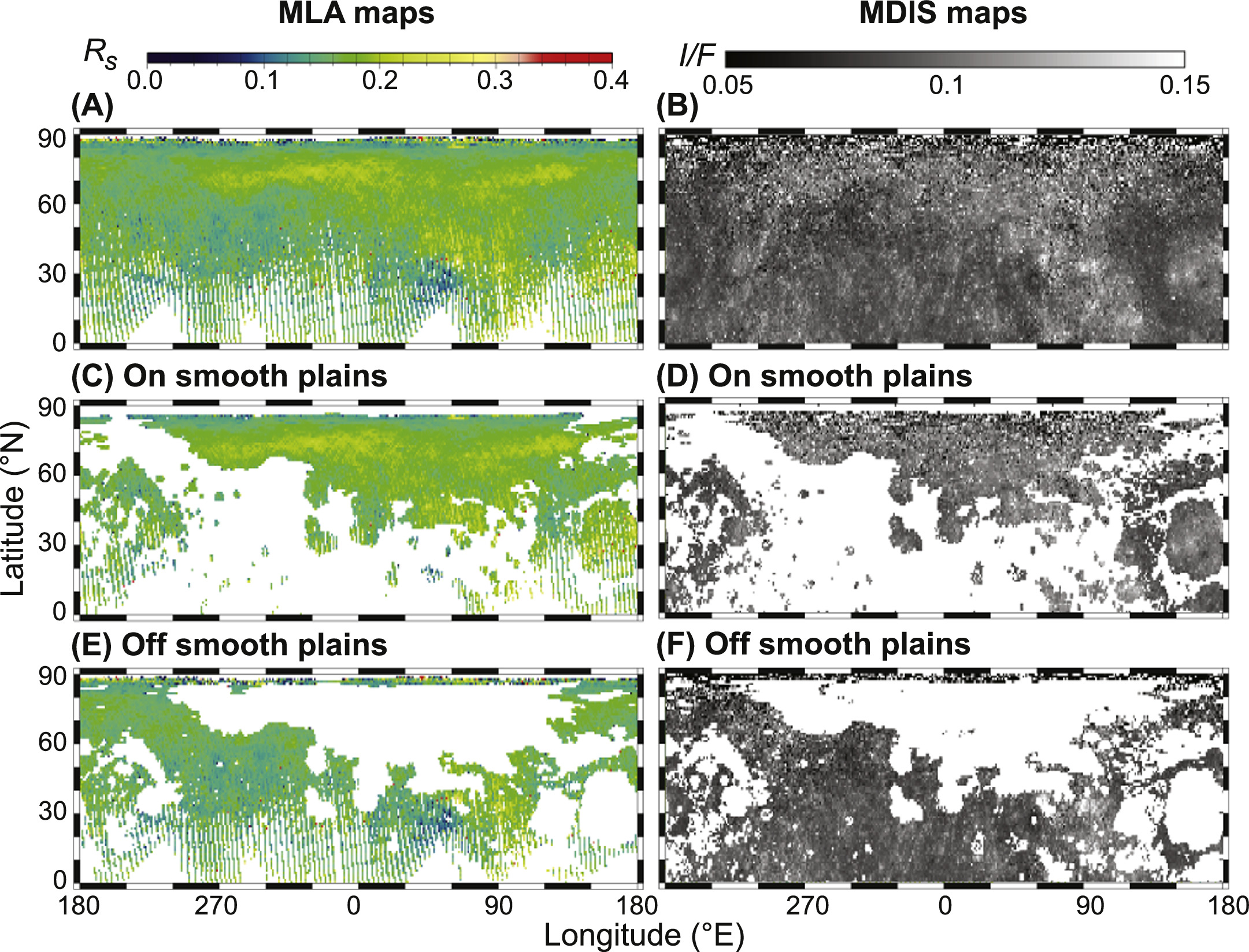
Figure 2. Northern hemisphere cylindrical maps of (left) 1064 nm surface reflectance from our newly empirically corrected MLA data and (right) I/F reflectance from the LOI MDIS map, resampled to the 1° × 1° resolution of our MLA map using a nearest-neighbor interpolation. Maps are shown for (A) and (B) all northern surfaces (areas in white correspond to areas with no data), (C) and (D) SP surfaces (Denevi et al. 2013), and (E) and (F) surfaces outside of the SPs. Note: a nearest-neighbor interpolation was used to average nearby MLA tracks and make them more visible in this figure.
Download figure:
Standard image High-resolution image2.2. MDIS Low Incidence Angle Data
The MDIS provides an independent measure of surface reflectance (Hawkins et al. 2007) that can be compared to our MLA map for analyzing albedo variations. We compared our newly calibrated MLA-derived Rs values to MDIS-derived I/F values (the ratio of radiance to incident solar irradiance) taken from the global MDIS low incidence angle (LOI) map. 12 This map was constructed using images illuminated at low solar incidence angles in order to minimize shadows and highlight different albedo properties of the surface materials (Chabot et al. 2016a; Denevi et al. 2016).
As described in the MDIS Software Interface Specification, 13 the images used to construct the LOI map were acquired by the MDIS narrow-angle camera (NAC) and wide-angle camera (WAC) filter 7 (both centered at ∼750 nm). The NAC was primarily used at higher altitudes, while the WAC was used to acquire basemap images from lower altitudes. When acquiring images for the LOI map, the MDIS pivot platform was used to point the WAC or NAC to low emission angles on the surface at times when the solar incidence angle was as low as possible. Images were empirically corrected, taking into the account temperature dependence of the charge-coupled device responsivity, readout timing used to correct for frame-transfer smear, and flat-field corrections, as described by Keller et al. (2013) and Denevi et al. (2016).
Following image calibration, LOI map images were photometrically normalized using a Kasseleinin–Shkuratov photometric model (Domingue et al. 2010, 2011, 2016) to a solar incidence angle (i = 30°), emission angle (e = 0°), and phase angle (g = 30°). For our analysis, we masked areas lacking MLA coverage and resampled the MDIS map (spatial sampling of 43 pixels deg–1) to allow comparison with the 1° × 1° resolution MLA map (Figure 2). In Section 3.3, we discuss the differences between the MLA and MDIS data sets.
2.3. Separation of Reflectance Data by Geologic Units
To help mitigate the inherent reflectance differences caused by local geology, the MLA and MDIS LOI data were separated into two groups, smooth plains (SPs) and nonsmooth plains (non-SPs), using the geologic classification by Denevi et al. (2013; Figure 2). We systematically find with both data sets that the reflectance is typically higher on SP surfaces in comparison to non-SP surfaces at a given latitude (Figure 3), demonstrating the importance of separating the two units in our analysis. Specifically, SPs are, on average, ∼10% more reflective (i.e., "brighter") than non-SPs in the MLA and MDIS data. The relative reflectance differences between SP and non-SP surfaces are consistent with previous work showing that some SPs tend to have relatively higher albedos (Denevi & Robinson 2008). Furthermore, SPs are also relatively younger than intercrater plains (ICPs), as indicated by relatively lower crater densities (Whitten et al. 2014). Crater densities suggest that SPs are predominately Calorian in age (>1.7 Ga using the time-stratigraphic system from Marchi et al. (2009) and >0.85 Ga using that from Le Feuvre & Wieczorek (2011), while ICPs are predominately Tolstojan to pre-Tolstojan in age (>3.8 Ga from Marchi et al. (2009) and >3.5 Ga from Le Feuvre & Wieczorek (2011), Whitten et al. (2014), Byrne et al. (2016), and Denevi et al. (2018)). Therefore, SP surfaces of the same composition as ICP surfaces may have had less exposure to space-weathering processes that darken the surface. We also note that particle size can affect the reflectance spectra of surface materials (e.g., Milliken & Mustard 2007), but to date, there is no clear evidence that the grain-size distributions of SPs and non-SPs are significantly different.
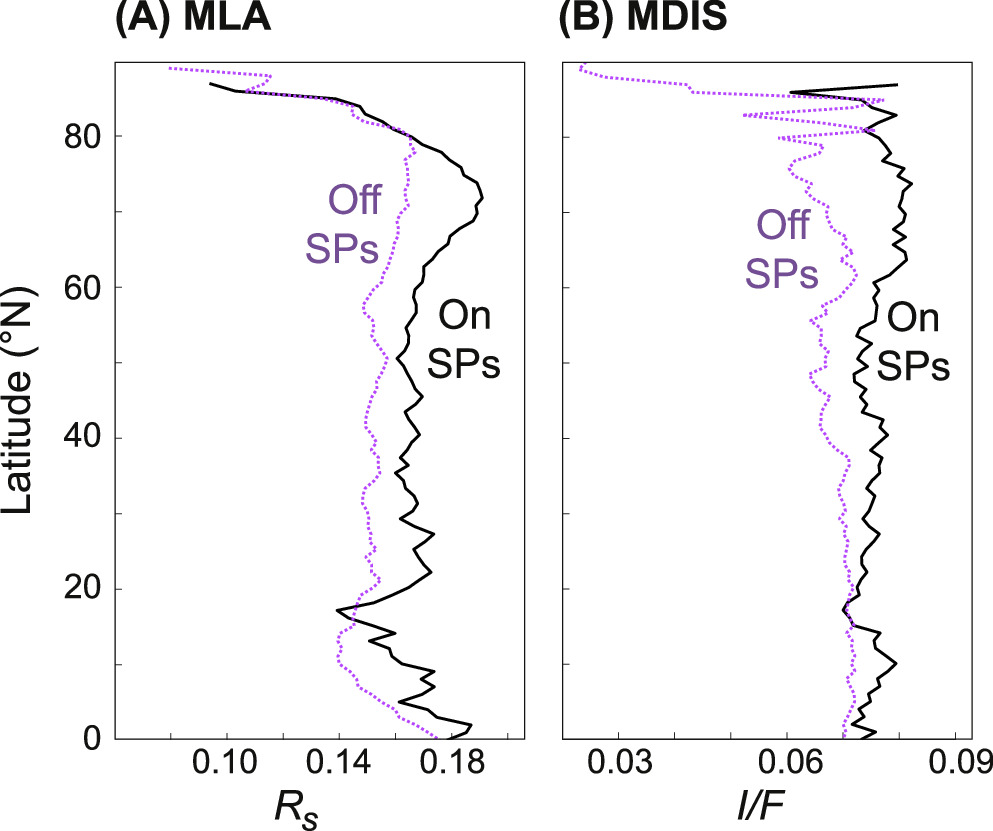
Figure 3. Median surface reflectance trends for SPs (black) and non-SPs (purple) plotted in 1° latitudinal bins, derived from (A) MLA Rs and (B) MDIS I/F values.
Download figure:
Standard image High-resolution imageIn addition to geologic units, the surface of Mercury has been mapped into major color units (e.g., Robinson & Lucey 1997; Robinson et al. 2008; Denevi et al. 2009; Ernst et al. 2010, 2015; Klima et al. 2018). It is likely that some darkening agent (presumably amorphous carbon) is responsible for the range of reflectance values observed in different color units (Murchie et al. 2015; Peplowski et al. 2016). Early analyses of Mariner 10 images acquired using 355 and 575 nm filters did not find any correlation between geologic units and color units (Hapke et al. 1975; Rava & Hapke 1987). Subsequent image calibration improvements, however, revealed that some SPs to have more steeply sloped visible reflectance spectra, interpreted to be from a lower abundance of opaques (Robinson & Lucey 1997). Additionally, recalibrated Mariner 10 images acquired using the clear filter indicated that some SPs have a relatively higher albedo in comparison to average Mercurian surfaces (Denevi & Robinson 2008), consistent with our analysis of 1064 nm reflectance (Figure 3).
2.4. Maximum Surface Temperature Models
Paige et al. (2013) previously created a thermal model of Mercury's north polar region (65°N–90°N) at a spatial resolution of 1 km. Using the same methods, we created a thermal model of Mercury's entire northern hemisphere (0°–90°N) at a resolution of 1° × 1° (i.e., at the same resolution as the MLA data). Thermal calculations were performed with a triangular topographic mesh derived from an MLA digital elevation model by projecting longitude, latitude, and elevation coordinates to a sphere with a radius of 2440.0 km. Surface temperatures were modeled at each mesh element. The thermal model uses a ray-tracing method to calculate the incident solar flux received at each mesh element over the time span of Mercury's biannual insolation cycle, divided into 352 equal time intervals (Paige et al. 2013). The Sun's disk is represented by 128 triangular elements for which the radiance decreases from the disk center in accordance with the Sun's limb-darkening curve (Negi et al. 1985; Paige et al. 2013) and is incrementally moved with respect to Mercury's center based on ephemeris data from JPL's Horizons System. 14 Between each time step, heat is conducted vertically between 150 layers, extending 2.5 m below the surface. At the upper boundary, absorbed solar flux and vertical conduction are balanced against infrared emission. At the lower boundary, we assume a constant heat flux of 0.01 W m−2. Two-layer soil thermophysical properties derived from remote observations of Mercury and the Moon are applied (Mitchell & de Pater 1994; Vasavada et al. 1999; Paige et al. 2013), and a surface solar spectrum albedo of 0.04 and emissivity of 0.90 at infrared wavelengths are used (Paige et al. 2013). Because we assume a constant albedo of 0.04 for the northern hemisphere, our maximum surface temperatures (MSTs) are typically warmer (maximum difference of 17 K) than those modeled by Bauch et al. (2021), who varied the surface albedo up to 0.2. Figure 4 shows the output of our modeling: a map of Mercury's MST over the course of a full Mercury solar day (176 Earth days). Our model is available for public use in the supplementary materials.

Figure 4. Map of modeled MST over the course of a full Mercury solar day at 1° × 1° resolution. The 50 K contours are shown in white lines.
Download figure:
Standard image High-resolution image3. Results
3.1. Temperature Regime–Dependent Variations in Surface Reflectance
According to the experimental results of Gleiter (1989), Ostwald ripening should be most effective on surfaces heated to temperatures warmer than ∼675 K (400 °C; Figure 5). Therefore, we compare the reflectance values for two temperature groups: surfaces with daily MST >675 K (i.e., surfaces where Ostwald ripening should be most efficient) and surfaces with daily MST <473 K (i.e., surfaces where Ostwald ripening is least efficient; Gleiter 1989; Noble et al. 2001; Noble & Pieters 2003). For this comparison, we exclude polar latitudes (north of 70°N) to avoid the influence of cold-trapped volatiles, which are discussed below in Section 3.2.1.

Figure 5. Modified from Gleiter (1989). Experimental measurements of the mean grain diameter (nm) of nanophase Fe0 after annealing for 10 hr under various heating temperatures. The shaded areas show the extent of the MST for the Moon and Mercury.
Download figure:
Standard image High-resolution imageWe find that the distributions of reflectance values for these two temperature groups overlap, but the distribution of potentially ripened surfaces with MST >675 K is described by a lower median in both the MLA and MDIS data (Figure 6). The median reflectance values of SPs with MST >675 and <473 K are 0.168 and 0.187 (10% darker for higher-temperature surfaces) when derived from MLA Rs and 0.073 and 0.083 (12% darker for higher-temperature surfaces) when derived from MDIS I/F. For non-SPs, the medians are 0.150 (MST >675 K) and 0.163 (MST <473 K; i.e., 8% darker for higher-temperature surfaces) when derived from MLA Rs and 0.070 and 0.075 (7% darker for higher-temperature surfaces) when derived from MDIS I/F. Wilcoxon rank-sum tests indicate that the null hypothesis (the two samples are from independent random samples with equal means) can be rejected at a 5% significance level; thus, the reflectance distributions of the two different MST regimes show statistically significant differences. However, these tests must be interpreted with caution, as they cannot inform us whether the observed reflectance differences are causal rather than a result of compositional variations that correlate with MST just by chance. Therefore, we cannot say that the MLA or MDIS reflectance trends are unambiguously attributable to systematic variations in MST.
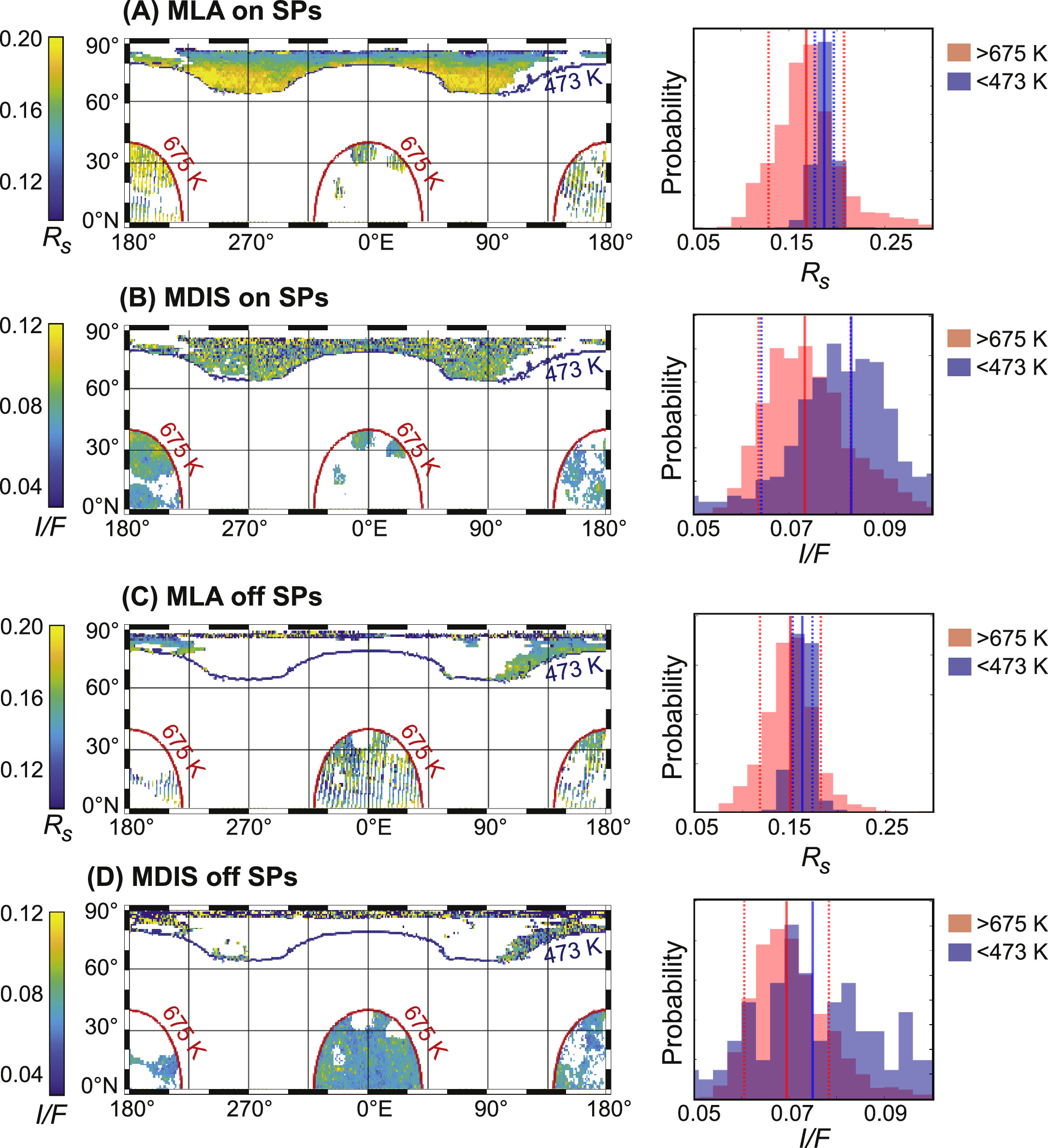
Figure 6. Comparison of reflectance values for surfaces with MST >675 and <473 K for (A) and (B) SP and (C) and (D) non-SP surfaces. The left panels show surfaces modeled to be these temperature ranges. The corresponding right panels show reflectance distributions of these surfaces for latitudes 0°–70°N. The median and ±1σ values of each distribution are noted by solid and dashed lines, respectively. The distribution plots are normalized and shown as a relative probability, where the sum of the bar heights is 1.
Download figure:
Standard image High-resolution imageThe low density of MLA shots at lower latitudes (Figure 7) is a major limitation on our analysis. Below ∼40°N, the MLA count density drops below ∼104 pulses per degree latitude. If we only consider latitudes between 40°N and 70°N, where the MLA count density is high and polar volatiles are absent, then there are no surfaces with MST >675 K (Figure 4), where Ostwald ripening is predicted to be most effective. For these latitudes, we instead compare surfaces where the MSTs are >473 and <473 K, representing surfaces where ripening is predicted to be most and least efficient, respectively (Gleiter 1989). Figure 8 shows the distribution of the reflectance values, which are nearly completely overlapped. We find that surfaces <473 and >473 K have nearly indistinguishable reflectance distributions; the distributions are nearly completely overlapped, although the median reflectance is still lower for the warmer surfaces (Figure 8).
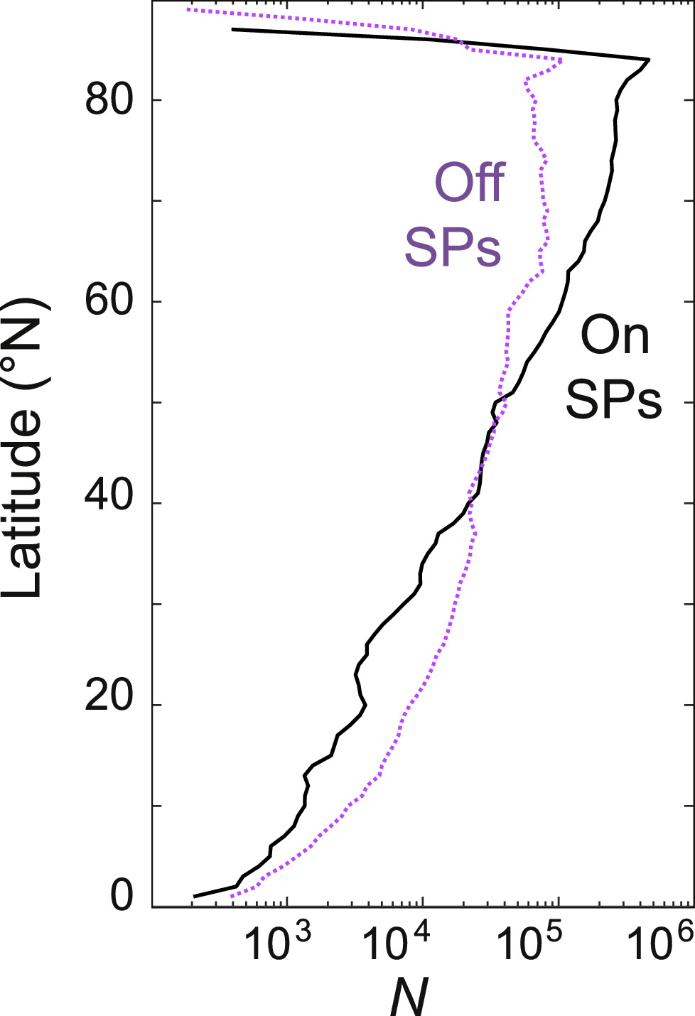
Figure 7. The number of MLA pulses (N) per degree latitude used to derive mean and median 1064 nm values as a function of latitude for SPs (black) and non-SPs (purple). The number of pulses drops off significantly at equatorial latitudes due to MESSENGER's orbit.
Download figure:
Standard image High-resolution image
Figure 8. Distribution of reflectance values for surfaces with MST >473 and <473 K for (A), (B), (E), and (F) SP and (C), (D), (G), and (H) non-SP surfaces. The distribution plots are normalized and shown as a relative probability, where the sum of the bar heights is 1. Reflectance values are derived from (A), (C), (E), and (G) MLA Rs and (B), (D), (F), and (H) MDIS I/F values. Distributions are shown for latitudes between (top) 0° and 70°N and (bottom) 40°N and 70°N.
Download figure:
Standard image High-resolution imageFor these same latitudes (40°N–70°N), we plot the 20th, 45th, and 70th percentile points for the distribution of Rs in 20 K wide MST bins and 2° wide latitudinal bins (Figure 9). We use these percentile points instead of the median and quartiles (25%, 50%, 75%) to minimize contamination from anomalously bright immature features, which may skew the statistics to slightly higher reflectance values. The non-SPs do not show any trend with respect to MST or latitude. For the SPs, however, there is some dependence (Figure 9). It may be a true physical trend, or it may be due to compositional variations that happen to correlate with temperature/latitude. We discuss the possible mechanisms that could create a true physical trend in Section 4.
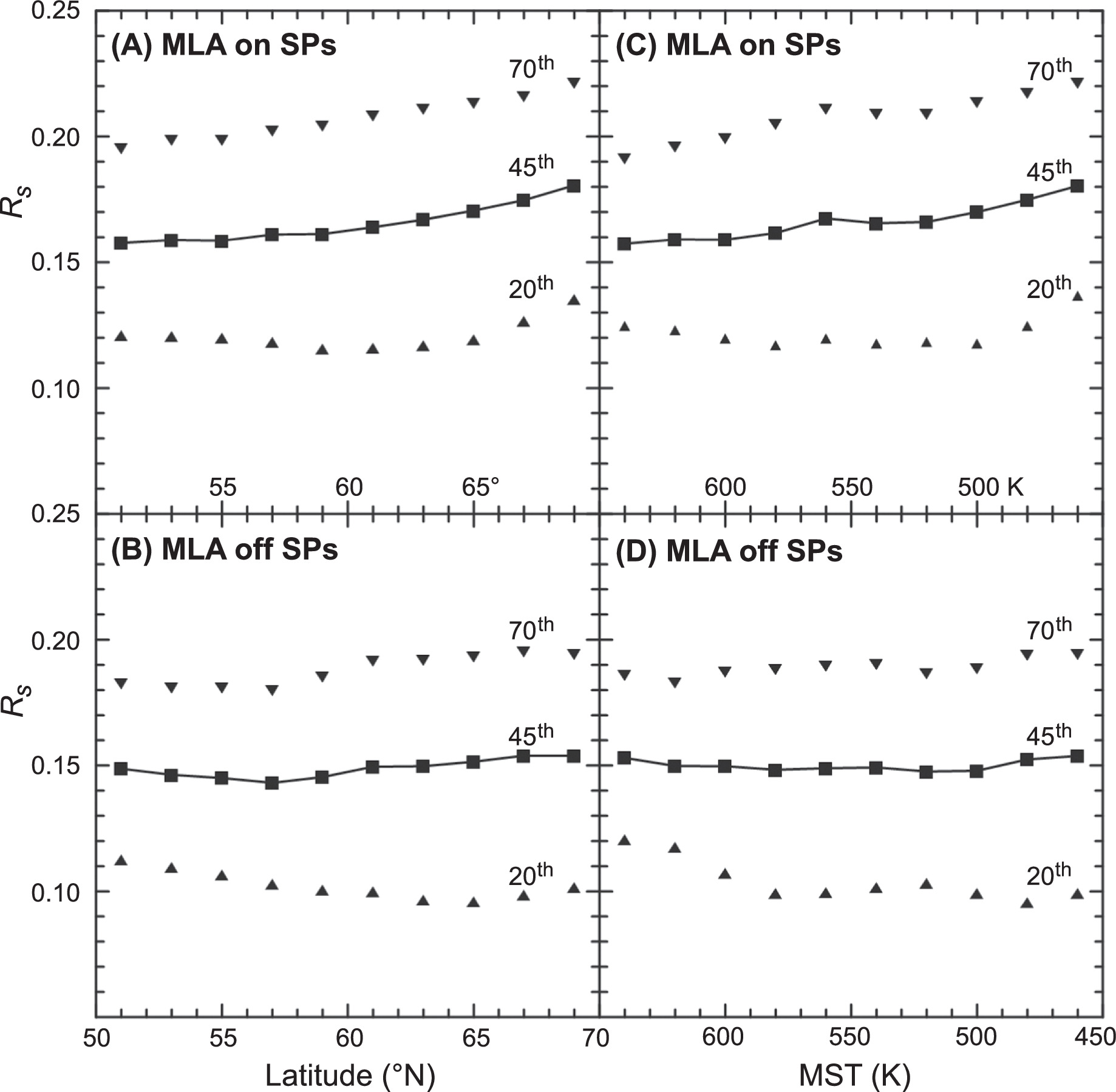
Figure 9. The 20th, 45th, and 70th percentile points for the distribution of MLA Rs in (A) and (B) 2° wide latitudinal bins and (C) and (D) 20 K wide MST bins, plotted for (A) and (C) the SPs and (B) and (D) non-SPs. Note that the temperature axes are inverted so that both higher latitudes and lower temperatures are toward the right.
Download figure:
Standard image High-resolution imageWe find that the amplitude of the systematic reflectance variations is similar to the difference in reflectance between the SP surfaces and other terrains (Figure 3). If the variations are caused by the MST, we would expect the amplitude to be higher for the dependence on temperature than it is for the dependence on latitude. We find that the amplitudes of the dependencies on temperature and latitude are similar. Likewise, if the variations are caused by the MST, we would expect the interquartile ranges to be narrower for temperature bins than for latitude bins. We find that the interquartile ranges are similar, although slightly narrower for the warmest temperature bins than for the southernmost latitude bins. However, the area in the warmest bins is smaller than the area in the southernmost bins, so the data may be encompassing less compositional variation. Thus, although Rs decreases toward the equator and with warming temperatures, we still cannot prescribe any causation at this point.
3.2. Longitudinal Variations in Surface Reflectance
In this section, we compare the reflectance trends of Mercury's four thermal poles, which, as discussed in Section 1, are characterized by large variations in temperature at lower latitudes and may be linked with variations in space-weathering signatures (Neish et al. 2013; Trang et al. 2017; Wilson et al. 2019). We analyze the median reflectance values in 1° latitudinal bins for each of the thermal poles, where hot poles are defined as 0°E ± 20°E and 180°E ± 20°E, and cold poles are defined as 90°E ± 20°E and 270°E ± 20°E. We divide our discussion of thermal pole trends into three latitudinal groups: polar latitudes, mid–low latitudes, and equatorial.
3.2.1. Polar Latitudes
There are variations in the 1064 nm surface reflectance (Rs ) at high latitudes related to the presence of volatiles (Figure 10). Poleward from ∼70°N, Rs decreases for all longitudes. This is interpreted to be due to the presence of surface lag deposits, whose low reflectance properties have been measured previously using the MLA (Neumann et al. 2013, 2017; Paige et al. 2014) and MDIS (Chabot et al. 2014). This decrease in Rs continues as the cold-trapping surface area proportion increases (Deutsch et al. 2016) and temperatures decrease, promoting the accumulation of low-reflectance volatile deposits with fewer regolith impurities (Paige et al. 2013, 2014; Deutsch et al. 2017). Around 85°N, polar temperatures are low enough to preserve water-ice deposits exposed directly at the surface on geologic timescales (Paige et al. 1992, 2013; Vasavada et al. 1999), and Rs increases (Figure 10), consistent with the increasing fractional surface coverage of bright water-ice deposits (Neumann et al. 2013; Paige et al. 2014; Deutsch et al. 2017; Chabot et al. 2018).
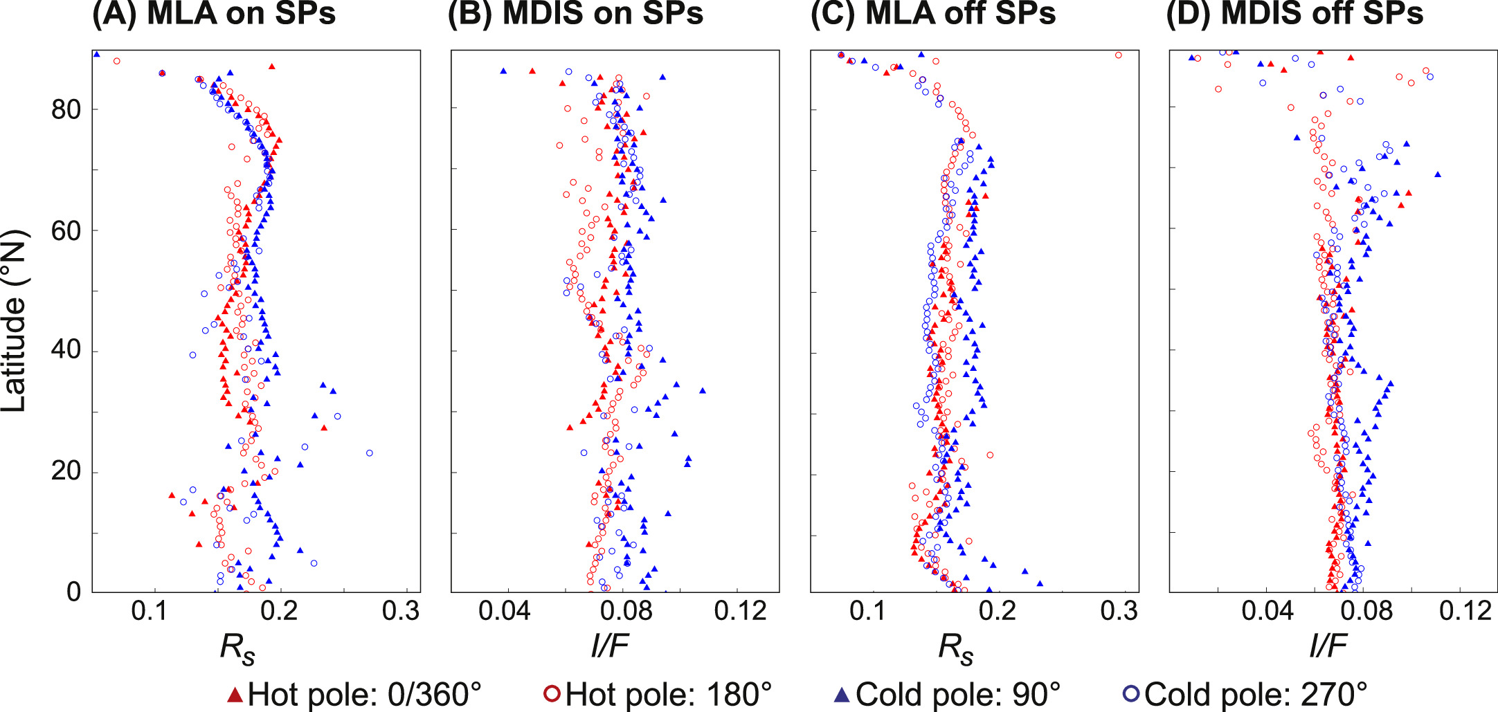
Figure 10. Median surface reflectance trends for (A) and (B) SPs and (C) and (D) non-SPs plotted in 1° latitudinal bins for Mercury's four thermal longitudes: hot pole 0°/360°E ± 20°E (filled red triangles), hot pole 180°E ± 20°E (open red circles), cold pole 90°E ± 20°E (filled blue triangles), and cold pole 270°E ± 20°E (open blue circles). Reflectance values are derived from (A) and (C) MLA Rs and (B) and (D) MDIS I/F values.
Download figure:
Standard image High-resolution imageDue to the low obliquity of Mercury, temperature variations between hot- and cold-pole longitudes in the polar regions are relatively small in comparison to those in the equatorial regions (Paige et al. 1992, 2013; Vasavada et al. 1999). However, between ∼70°N and 80°N, lower temperatures at cold-pole longitudes are observed to preferentially promote the retention of frozen volatiles in comparison to hot-pole longitudes (Harmon et al. 2001, 2011; Harmon 2007; Chabot et al. 2012, 2013). Our newly calibrated MLA data indicate that Rs is systematically lower at cold-pole longitudes than at hot-pole longitudes for SPs between ∼70°N and 80°N (Figure 10(A)), consistent with the finding that radar-bright ice deposits insulated by low-reflectance lag deposits are preferentially distributed along cold-pole longitudes at these latitudes (Chabot et al. 2012, 2013). As expected, this systematic difference is not apparent in the MDIS LOI maps (Figure 10(B)) because they are not sensitive to the reflectance of cold-trapped volatiles. This is because the cold-trapped volatiles are within areas of shadow, which appear dark in the global LOI data. While resolving the surface reflectance of cold-trapped volatiles is possible by adjusting the stretch of some WAC broadband filter images with sufficient light scatter (Chabot et al. 2014, 2016b, 2018; Deutsch et al. 2019), this effort was not a part of the LOI map creation. Also, note that the northern polar latitudes are predominantly covered by SPs (Figure 2), so trends off SPs (Figures 10(C) and (D)) are not considered.
3.2.2. Low–midlatitudes
At low-to-midlatitudes (∼5°N–60°N), the temperature variations between longitudes are greater than they are at the poles, reaching an ∼100 K difference in MST at 45°N (Bauch et al. 2021). At these latitudes, we find that Rs is typically lower along hot-pole longitudes than it is along the 90°E cold pole (Figure 10). The suppressed reflectance of hot-pole longitudes is stronger for SPs than it is for non-SP surfaces. The 90°E cold pole typically has the highest reflectance of the four thermal poles, both in the MLA and MDIS data. This is consistent with the decrease in MMI along the 90°E cold pole observed by Wilson et al. (2019), suggesting that surface materials along this longitude are less optically mature and brighter than surface materials along other thermal longitudes. This is also consistent with the enhancement of microphase Fe at hot-pole longitudes modeled by Trang et al. (2017).
Figure 10 additionally shows that the longitudinal median reflectance values vary between the two hot poles, as well as between the two cold poles. Specifically, reflectance is typically lower along the 0°E hot pole than it is along the 180° hot pole and typically lower at the 270°E cold pole than it is at the 90°E cold pole, which again is consistent with low MMI values along the 90°E cold pole (Wilson et al. 2019).
3.2.3. Equatorial Latitudes
We observe that the median MLA Rs tends to increase between 0° and ∼5°N off the SPs and at hot-pole longitudes on the SPs (Figure 10). Systematic errors in the data set are a warranted concern at these latitudes, especially given that we have recalibrated the data empirically with a function of time, range, and emission angle (Section 2.1), on top of the uncertainties of the measurement algorithm itself (Neumann et al. 2013). But the emission angles in the calibrated data set are low, indicating that pulse spreading is not extreme, and we do not find any signal suggestive of an edge effect of the recalibration function. We note, however, that there is a steep drop-off in the number of MLA measurements with decreasing latitude; the number of MLA pulses used to derive median Rs values is ∼100–1000 per degree latitude at these equatorial latitudes, in comparison to ∼1000–10,000 per degree at low–midlatitudes and ∼10,000–100,000 per degree at high latitudes (Figure 7). Of note, the MDIS LOI data do not show a similar increase (Figure 10).
To further analyze the MLA Rs trends in the equatorial region, we considered the MLA data between 0° and 5°S to test whether the apparent brightening is roughly symmetric about the equator. A symmetry could indicate that the apparent equatorial brightening is real because temperatures and impact flux—both of which can cause enhanced brightening—are modeled to be roughly symmetric about the equator due to the planet's low obliquity (Paige et al. 2013; Pokorný et al. 2018; Bauch et al. 2021). Alternatively, a lack of symmetry and a continued runaway brightening could indicate that the MLA data southward of ∼5°N are saturated with artifacts. With the limited southern MLA data that we have (mostly cold-pole longitudes), only the SPs 90°E longitude Rs values tend to decrease south of the equator (Figure 11). Thus, because the runaway effect continues, the MLA has exceptionally low data density at these latitudes (Figure 7), and the MDIS LOI data do not show a similar trend (Figure 10), we suspect that the apparent equatorial brightening is not a real effect.
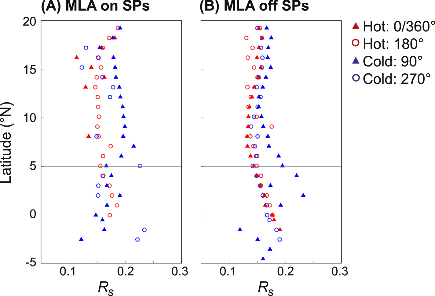
Figure 11. Median surface reflectance derived from MLA Rs for (A) SPs and (B) non-SPs plotted in 1° latitudinal bins between −5°N and 20°N for Mercury's four thermal longitudes: hot pole 0°/360°E ± 20°E (filled red triangles), hot pole 180°E ± 20°E (open red circles), cold pole 90°E ± 20°E (filled blue triangles), and cold pole 270°E ± 20°E (open blue circles).
Download figure:
Standard image High-resolution imageHowever, as an interesting thought exercise, we consider mechanisms that could be responsible for equatorial brightening. One possibility is enhanced bombardment; impact bombardment can lead to an increase in surface reflectance as new impacts expose relatively bright materials to the surface and the bombardment rate is higher than the maturation/darkening rate. Models of the predicted impact flux of micrometeoroids suggest that Mercury experiences enhanced bombardment in its equatorial region (Section 4.2). This is because high-energy meteoroid impacts originate from long-period comets that hit Mercury's equator from steep angles, resulting in relatively higher ejecta production rates, while the polar regions experience these impacts on grazing angles (Pokorný et al. 2018, 2021).
Alternatively, it is possible that the observed brightening is consistent with the overmaturation of surface materials, as Starukhina & Shkuratov (2003) predicted could occur on Mercury. Overmaturation refers to the continued growth of iron grains to sizes ≥0.3 μm, which Starukhina & Shkuratov (2003) argued could cause a decrease in absorption, an increase in scattering, and a brightening of "overmatured" regolith. Interestingly, we note that Trang et al. (2017) found an enhancement in microphase Fe grains at the equator (their Figure 6(b)), which could also be consistent with overmatured surfaces.
Finally, an abundance of bright geologic features concentrated at these latitudes could also lead to local brightening. For example, both pyroclastic deposits (Kerber et al. 2009, 2011; Goudge et al. 2014) and hollows (Blewett et al. 2011, 2013) often have high reflectance properties. However, both of these features are relatively small (∼meters to hundreds of meters), especially in comparison to the 1° × 1° binning performed on the MLA data, and thus would need to be highly abundant in order to influence the MLA signal. Surveys of the equatorial region do not reveal an anomalous abundance of these features (Kerber et al. 2009, 2011; Blewett et al. 2011, 2013; Goudge et al. 2014); thus, they are unlikely to be responsible for the equatorial brightening we observe.
Invoking any of these explanations to explain the apparent MLA equatorial brightening would imply that some threshold has been met or exceeded (i.e., "enough" recent bombardment has occurred, "enough" overmature regolith has developed, or "enough" bright features are concentrated specifically in the equatorial region). Such thresholds (i.e., when each of these mechanisms would begin to affect the binned MLA reflectance) are undetermined. Determining (1) whether this brightening is real (rather than an MLA edge effect) and (2) the potential cause of this brightening could be investigated with the improved 1064 nm equatorial surface coverage by the BepiColombo Laser Altimeter (BELA), which has the same observation wavelength as MLA (Thomas et al. 2021).
3.3. Variations between MLA and MDIS Reflectance Data
Both the MLA and MDIS LOI data provide a measurement of surface reflectance, but variations in the two data sets exist due to different observation wavelengths, different observation/illumination geometries, and potentially imperfect calibrations. It is important to consider the spectral mismatch between the MLA 1064 nm data and the MDIS 750 nm band; the MLA data represent a normal albedo (0° phase angle), while the MDIS data were collected across a much wider range of phase angles. One major difference between the data sets is that the MDIS LOI map is not sensitive to the presence of low- and high-reflectance polar volatiles because MDIS was not designed to see within permanently shadowed regions, where the volatiles are cold-trapped, at the nominal exposure times used for mapping of illuminated surfaces (e.g., Chabot et al. 2014, 2018).
In general, though, the 1064 nm reflectance and the I/F values show similar latitudinal trends for the four thermal poles (Figures 10). The MLA and MDIS data both indicate that the hot poles are typically darker than the 90°E cold pole in the low–midlatitudes, both on and off the SPs (Figure 10). Additionally, the MLA and MDIS data both indicate that the 270°E cold pole is often darker than either hot pole for non-SP surfaces (Figures 10(C) and (D)). Given the general agreement, the MDIS LOI data could provide important insight specifically at latitudes where MLA data are sparse or nonexistent (i.e., low-to-mid-northern latitudes and all southern latitudes).
The relative reflectance trends of MLA Rs and MDIS I/F data are most different at polar (>∼70°N) and equatorial latitudes (<∼25°N; Figure 12). We suspect that some of the differences in polar trends are related to MLA being sensitive to low- and high-reflectance volatiles in shadows (Neumann et al. 2013; Paige et al. 2014; Deutsch et al. 2017), and some of the differences in equatorial trends may be biased by MLA's low count density (Figure 6).
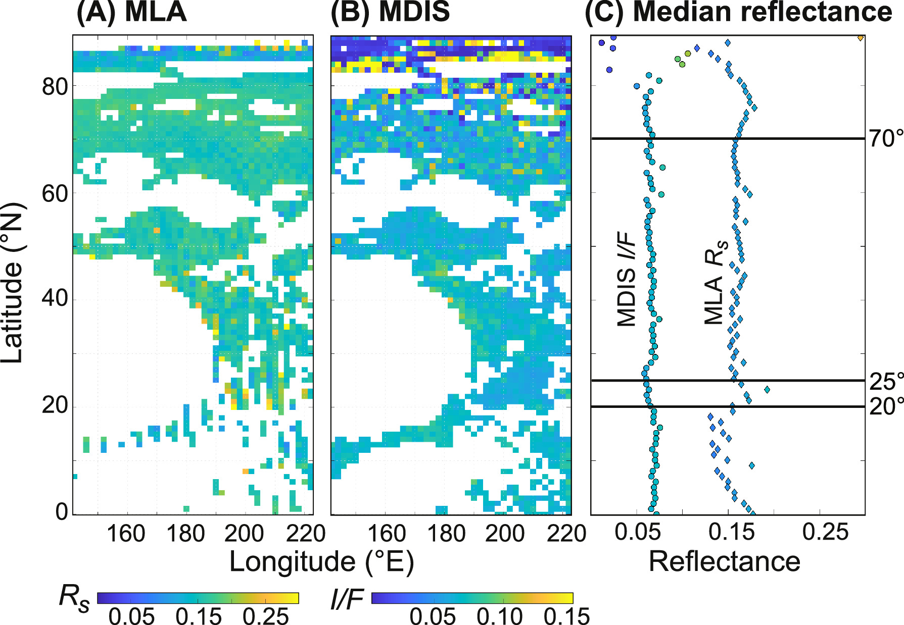
Figure 12. Reflectance values of the 180°E hot-pole area (±20°E) for non-SPs in the northern hemisphere, derived from (A) MLA and (B) MDIS at a 1° × 1° resolution. (C) The median MLA-derived Rs and MDIS-derived I/F values of the 180° hot-pole area for each degree of latitude.
Download figure:
Standard image High-resolution imageThe MLA Rs values are measured at zero phase angle, thus representing reflectance at the opposition surge, which depends on micron-to-millimeter-scale surface structure (e.g., Shkuratov et al. 1999; Hapke 2002). This affects correlation with MDIS I/F in two ways. The first way is related to natural structure variations; for example, regolith disturbances from small recent impacts would make a noiselike contribution to measured Rs values, thus reducing the correlation. Second, systematic regolith maturation may affect zero phase angle reflectance and moderately low phase angle reflectance in somewhat different ways. In turn, MDIS I/F is measured at different illumination/observation geometries and then reduced to the standard geometry assuming some photometric function (Domingue et al. 2010, 2011, 2016). The inevitable inaccuracy of knowledge of the photometric function and its natural variations would make a noiselike contribution to the reduced I/F values, thus reducing the correlation with Rs .
Furthermore, due to MESSENGER's orbit and keep-out zones (Vaughan et al. 2005), MDIS also has some systematic viewing/illumination angle trends of which to be mindful. For example, hot-pole longitudes were easier than other longitudes to image at low phase and incidence angles. Consequently, higher emission angles were typically required to image non-hot-pole longitudes, whose lowest phase and incidence angles were relatively higher than those of hot-pole longitudes. Additionally, higher latitudes were imaged at higher incidence angles than lower latitudes. Due to these trends, terrains with more topography/shadows tend to have lower average reflectance values even after photometric corrections because they do not account for topography. The result is observable in Figure 12(B), where the MDIS data are noisier at high latitudes because of shadows and Sun-facing slopes.
4. Discussion: Space-weathering Effects on Surface Reflectance
As introduced in Section 1, various space-weathering processes can alter the reflectance of a surface, including random impacts by small particles or debris, as well as irradiation by electromagnetic radiation or atomic particles from the Sun, magnetosphere, or galactic sources (Pieters & Noble 2016). At 1064 nm, the observation wavelength of MLA, space weathering decreases the Rs of the surface in response to the accumulation of iron/opaque materials (Hapke 2001; Sasaki & Kurahashi 2004; Noble et al. 2007; Lucey & Riner 2011; Domingue et al. 2014; Izenberg et al. 2014; Pieters & Noble 2016; Trang et al. 2017). The intensity of this darkening effect is a function of the target surface (composition, particle size, texture), location (temperature, impact speed and flux, radiation environment), and exposure time (Pieters & Noble 2016). Regolith gardening, as well as resurfacing processes (i.e., larger-scale processes like impact cratering or volcanism), can redistribute space-weathering products, bury space-weathered materials, and excavate less-weathered materials. In this section, we discuss how the location-dependent variations in Rs may be related to surface temperature (Section 4.1), impact flux (Section 4.2), and/or solar wind flux (Section 4.3).
4.1. Influences of Surface Temperature
The lower reflectance values of surfaces with daily MST >675 K in comparison to surfaces with daily MST <473 K (Figure 6) are consistent with the hypothesis that high temperatures have promoted a darkening of the surface at low–midlatitudes. This finding is consistent with the process of Ostwald ripening, where high temperatures cause nanophase opaques to coalesce and grow into larger, microphase particles (Noble et al. 2001, 2007; Noble & Pieters 2003), which results in a stronger optical effect for the same mass. Previous experiments demonstrated that npFe0 particles can grow from 8 to >50 nm in size after annealing for 10 hr at ∼575 K (300°C) and to >175 nm at ∼775 K (500°C; Gleiter 1989; Figure 5). Noble et al. (2001) noted that while this study was not designed to replicate Mercurian conditions (it used iron particles in grain-to-grain contact rather than isolated iron particles suspended in a glass matrix), it does suggest that Ostwald ripening could be an effective process on Mercury, particularly at high temperatures.
The particle growth rate resulting from Ostwald ripening increases exponentially with temperature (Figure 5) and should be fastest at lower latitudes, along hot-pole longitudes, and on the dayside of Mercury (Noble et al. 2001; Noble & Pieters 2003). In theory, there may be some small feedback occurring here, because the brightness of a surface influences its temperature such that darker surfaces are warmer during the day than relatively brighter surfaces located at similar latitudes and longitudes (Bauch et al. 2021). However, the magnitude of the reflectance variations we measured (Figure 5) is unlikely to change the temperature meaningfully. At some latitude on Mercury—in cooler, more temperature thermal regimes—Ostwald ripening should no longer be effective, but this transitional latitude has yet to be determined. Noble et al. (2001) predicted that Ostwald ripening would be most effective on Mercury at temperatures >675 K, which our thermal model indicates occurs between 0° and 40° when considering the MSTs over the course of a full Mercury solar day, depending on the local longitude (Figure 4). As described in detail in Section 3, surfaces with MST >675 K are described by a statistically meaningful lower median than surfaces with MST <473 K (Figure 6). Ostwald ripening efficiency increases exponentially with temperature (Figure 5).
The eccentricity of Mercury is currently ∼0.206 but may have varied over time, as predicted by various spin–orbit evolution models (e.g., Correia & Laskar 2004, 2009, 2012; Laskar 2008; Boué et al. 2012; Noyelles et al. 2014). In its more recent geologic past, Mercury may have had a relatively lower eccentricity. At lower eccentricities, the difference between the cold and hot poles would have been weaker, and the hot-pole MST would have been lower, making Ostwald ripening less effective. However, substantial periods of higher eccentricity are predicted to have occurred during Mercury's earliest history. During such periods, the MST of the hot poles would have been higher, the sufficiently hot areas around the hot poles would have been wider, and Ostwald ripening effects would have been more likely to occur. Thus, thermal regimes where Ostwald ripening would be most efficient are likely to have varied throughout Mercury's history. Overall, more detailed work is needed to understand how the timescales of Ostwald ripening compare to the timescales of Mercury's spin–orbit evolution and impact gardening, which may have erased any early signatures of eccentricity/thermal regime–related reflectance variations by mixing the regolith.
Future experimental work could provide a better understanding of how this temperature-related reflectance variation may be related to Ostwald ripening (see Section 5). For example, heating experiments of lunar soils formed a population of Fe nanoparticles, whose size distribution evolution was consistent with that predicted by growth through Ostwald ripening (Thompson et al. 2017). Similar experiments for Mercurian mineralogies (i.e., with carbon/graphite; Trang et al. 2018; McGlaun et al. 2019; Thompson et al. 2021) could provide insight into particle size distributions and growth timescales for Ostwald ripening on Mercury. Overall, laboratory work informed by our observations could help quantify the magnitude, critical temperatures, and timescales of Ostwald ripening under Mercurian conditions, as well as the size and quantity of the nanophase opaques required to darken the surface to the measured 1064 nm reflectance.
4.2. Influences of Micrometeoroid Bombardment
Ostwald ripening is not the only process that can be invoked to explain the relative darkening of a surface; micrometeoroid bombardment also plays a role in space weathering through the physical fragmentation of regolith into finer particles and production of melt and vapor (Adams & McCord 1971; Cintala 1992; Pieters et al. 1993; Hapke 2001; Noble et al. 2007; Domingue et al. 2014). These processes are predicted to be particularly effective at Mercury due to high micrometeorite fluxes and impact velocities (Cintala 1992; Noble et al. 2007).
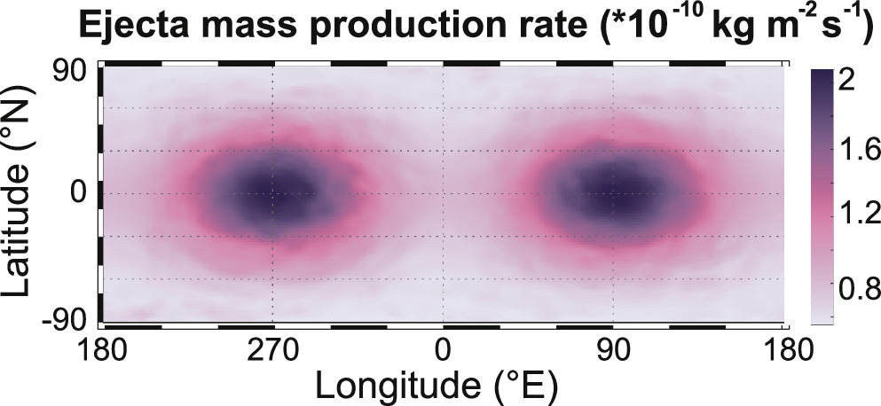
Pokorný et al. (2018) previously modeled the meteoroid environment around Mercury sourced from main-belt asteroids and Jupiter-family, Halley-type, and Oort Cloud comets. Using the models from Pokorný et al. (2018, 2021), we present a new spatially resolved model of the mass production rate of ejecta for Mercury's surface in Figure 13. The production rate is calculated over a full Mercurian solar day that covers the entire range of surface–meteoroid environment configurations. For this model, we assume that the global shape for the meteoroid environment stays the same during Mercury's entire precession cycle (∼226 kyr) and that the orbital eccentricity and inclination of Mercury are constant during the precession cycle.
Figure 13. The ejecta mass production rate (kg m−2 s−1) from micrometeoroid bombardment averaged over a full Mercurian solar day. Ejecta production is primarily dependent on the product of impact flux and impactor velocity, which is highest around the equatorial regions and peaks during the perihelion passage at 06:00 Mercurian local time (Pokorný et al. 2018).
Download figure:
Standard image High-resolution image
Impact energy flux and ejecta production are dependent on meteoroid impact velocity, which is highest around the equatorial regions and comes from long-period comet meteoroids (Pokorný et al. 2018, 2021). There are two longitudes that experience enhanced meteoroid impacts, centered at (0°N, 90°E) and (0°, 270°E), that are a result of the combined imprint of the peak meteoroid ejecta production rates at 06:00 local time, the nonzero eccentricity of Mercury, and the effect of 3:2 spin–orbital resonance. These two longitudes with enhanced meteoroid bombardment are offset by 90° from the hot-pole longitudes and are not correlated with longitudinal variations in surface reflectance (Section 3.2). The bombardment model informs two key points. First, micrometeoroid bombardment is not likely to be responsible for the lower reflectance values observed along hot-pole longitudes (Figure 10). And second, micrometeoroid bombardment could weaken longitudinal darkening trends related to thermal regimes because of this 90° offset.
Of note, various irradiation experiments have demonstrated bombardment-related space-weathering effects in laboratory settings. For example, Stojic et al. (2023) performed laser-induced ablation on synthetic forsterite and observed the accumulation of amorphous ejecta materials, which tend to be of low reflectance in the VIS-NIR wavelengths (e.g., dark amorphous carbon; Brunetto et al. 2006). Additionally, Sasaki & Kurahashi (2004) studied the formation of nanophase Fe particles in olivine and pyroxene samples after using pulse laser irradiation to simulate micrometeoroid impact heating. They measured the growth of nanophase Fe particles after repetitive irradiation and a change of reflectance of <10% in the VIS-NIR region (Sasaki & Kurahashi 2004), which is similar to the change we measured between different thermal regimes (Sections 3.1, 4.1). However, as discussed above, areas with the most intense micrometeoroid bombardment on Mercury do not correlate with areas with relatively lower reflectance values. Future experiments using mixed mineralogies more representative of Mercury's surface could better inform the reflectance changes expected from different space-weathering processes, including micrometeroid impacts versus Ostwald ripening.
4.3. Influences of Ion Implantation
Finally, solar wind ion irradiation is another mechanism that can space-weather airless bodies (Pieters et al. 2000; Chapman 2004; Vernazza et al. 2009; Noguchi et al. 2011, 2014). Mercury's magnetic field, albeit weak, can help shield its surface from solar wind bombardment in some locations while focusing impacting particles to other locations, thus creating regional differences in the degree of space weathering (Domingue et al. 2014). During moderate solar wind conditions, the intrinsic magnetic field of Mercury prevents substantial solar wind implantation of the equatorial regions (Killen et al. 2001; Kallio & Janhunen 2003). During more extreme solar events (e.g., coronal mass ejections, high-speed solar wind, interplanetary magnetic clouds), the solar wind plasma can reach the entire dayside of Mercury (Slavin et al. 2014; Pfleger et al. 2015; Fatemi et al. 2020).
Models predict that large fractions of the magnetosphere of Mercury are open to the solar wind plasma around the cusps, allowing solar wind ions to reach the surface (e.g., Wurz et al. 2019). Additionally, observations indicate that solar wind plasma was present in the cusps during nearly every MESSENGER orbit (Raines et al. 2014). Model predictions about the size and location of the magnetosphere's open fractions depend largely on solar wind speed, solar wind density, and magnetic field estimates but suggest that ion precipitation is largely concentrated at latitudes between 40° and 60° (Delcourt et al. 2003; Kallio & Janhunen 2003; Massetti et al. 2003; Wurz et al. 2019).
Kallio & Janhunen (2003) modeled the morphology of Mercury's magnetic field to study the flux of solar wind protons during four different upstream cases. Similarly, Pfleger et al. (2015) 3D-modeled solar wind ions on the surface of Mercury for various conditions (including expected mean conditions, as well as more extreme conditions by varying solar wind density and speed and magnetic field direction and strength). Both studies suggested that the particle flux of solar wind protons may nominally be highest for northern and southern latitudinal bands between 20° and 60°, slightly equatorward from the open/closed magnetic field line boundary. We do not find any significant correlation between darkening and this latitudinal band. Furthermore, solar wind bombardment is not predicted to have longitudinal variations over timescales relevant to the precession of the planet (Kallio & Janhunen 2003; Pfleger et al. 2015). Thus, variations in solar wind flux are not consistent with the observed variations in reflectance.
5. Future Work to Hunt for Ostwald Ripening
The BELA (Thomas et al. 2021) on board BepiColombo will play a critical role in our understanding of spatial variations in reflectance/space weathering. The BELA will measure surface reflectance at the same 1064 nm wavelength as MLA and will cover the equatorial region much more thoroughly and uniformly. Thus, it can provide insight into equatorial reflectance properties, as well as southern hemisphere reflectance patterns. Reflectance measurements of this regions are particularly important because these regions are characterized by high temperatures, where Ostwald ripening could occur. Also on board BepiColombo is the Spectrometer and Imaging for MPO BepiColombo Integrated Observatory SYStem (SIMBIO-SYS), an instrument suite consisting of a high-resolution color camera (broad spectral bands in the 400–950 nm range), a stereo color camera (broad spectral band in the 400–900 nm range), and a hyperspectral imager (as high as 6 nm sampling in the 400–2000 nm spectral range; Cremonese et al. 2020). SIMBIO-SYS will provide VIS and NIR I/F data at global and regional scales that could improve spatial coverage, spatial resolution, and the spectral range for testing for Ostwald ripening signatures on Mercury. This is especially important for enhancing spectral coverage of colder surfaces; the highest-quality MESSENGER spectral data cover latitudes equatorward of ∼63°, and surfaces where Ostwald ripening is least efficient (i.e., MST <473 K) begin at ∼65°. Thus, SIMBIO-SYS at more poleward latitudes would enable spectral comparisons between the various thermal regimes studied here.
Additionally, laboratory experiments (e.g., Thompson et al. 2017) using Mercurian-relevant mineralogies would provide new and important constraints on the temperature-dependent rates of Ostwald ripening predicted for Mercury (e.g., Trang et al. 2018; McGlaun et al. 2019; Thompson et al. 2021). Such experiments would inform better predictions of where ripening could occur based on temperature and surface composition, as well as the magnitude of reflectance variations expected across various NIR wavelengths (including MLA's and BELA's 1064 nm observation wavelength). These experiments would, in turn, enable more informed quantitative modeling of the optical effects of space weathering using MESSENGER and BepiColombo data, resulting in improved estimates of the intensity of space weathering and the amount of altered material (e.g., Lucey & Riner 2011; Lucey et al. 2015; Trang et al. 2015, 2017).
6. Conclusions
The thermal environment of Mercury is known to be particularly extreme, with some surfaces experiencing temperatures >700 K over the course of a day. Hotter temperatures are characteristic not only of the equatorial regions but also along the so-called "hot-pole" longitudes (centered at 0°E and 180°E) due to the planet's highly eccentric orbit and unique 3:2 spin–orbit resonance (Soter & Ulrichs 1967; Paige et al. 2013). It has been predicted that the high temperatures on Mercury could promote thermal annealing by Ostwald ripening, where nanophase metal particles (a product of space weathering) coalesce and grow into larger, microphase particles, resulting in lower albedo (Noble & Pieters 2003; Noble et al. 2007).
To test whether Ostwald ripening may have affected Mercury's global reflectance trends, we analyzed spatial variations in the surface reflectance of the northern hemisphere using two independent data sets (Figure 2). First, we recalibrated mid- and low-latitude MLA data to analyze the 1064 nm surface reflectance (Rs ). Second, we utilized MDIS LOI data, which highlight different albedo properties of surface materials, reported in I/F (the ratio of radiance to incident solar irradiance; Chabot et al. 2016a; Denevi et al. 2016). Spatial relationships between surface reflectance and temperature were analyzed using a new northern hemisphere model of MST experienced over the course of a full Mercury solar day (Figure 4).
After accounting for latitude and geologic terrain, we found that Rs and I/F are typically lower for surfaces where Ostwald ripening is predicted to be most effective (MST >675 K) than for surfaces where Ostwald ripening is predicted to be ineffective (MST <473 K; Figure 6). This trend was slightly greater in the SPs; SP surfaces >675 K are 10% and 12% darker than surfaces <473 K in the MLA Rs and MDIS I/F data, respectively, while non-SP surfaces >675 K are 8% and 7% darker than surfaces <473 K. We suggest that the relatively lower reflectance values of high-temperature surfaces may be the result of thermal annealing, where Ostwald ripening is occurring (Noble & Pieters 2003).
Furthermore, we found that in the low–midlatitudes, Rs and I/F are typically lower along hot-pole longitudes (0°E and 180°E) than along the 90°E cold pole, especially in the SPs (Figure 10). This is consistent with previous work identifying an enhancement of microphase Fe at hot-pole longitudes relative to cold-pole longitudes (Trang et al. 2017) and an observed decrease in optical maturity along the 90°E cold pole relative to hot-pole longitudes (Wilson et al. 2019). We found that the longitudinal reflectance variations are correlated with temperature variations, rather than variations in micrometeoroid bombardment or solar wind fluxes. In fact, we presented a new spatially resolved model showing that meteoroid bombardment is predicted to be highest at cold-pole longitudes (Figure 13). Therefore, locally higher micrometeoroid fluxes are not likely to be responsible for the depressed reflectance along hot-pole longitudes and could even weaken longitudinal darkening trends related to thermal regimes because of this 90° offset.
Finally, sparse MLA coverage of low latitudes (where MSTs are >675 K) is a limiting factor in this analysis (Figure 7). Future BELA coverage of Mercury's equatorial regions will be crucial in constraining temperature regime–dependent reflectance variations of high-temperature surfaces. Additionally, future laboratory work and quantitative modeling are important next steps in determining the magnitude of darkening that occurs at 1064 nm for Mercurian mineralogies in response to high temperatures (Trang et al. 2017, 2018; McGlaun et al. 2019; Thompson et al. 2021).
Acknowledgments
We gratefully acknowledge the helpful reviews by two anonymous reviewers and editorial handling by Edgard G. Rivera-Valentín. Support for A.N.D. was provided by NASA's SSERVI RESOURCE. Support for P.P. was provided by NASA's Planetary Science Division Research Program through ISFM work package EIMM at NASA Goddard Space Flight Center, NASA award Nos. 80GSFC21M0002 and 80NSSC21K0153.
Data Availability
The MLA data analyzed in this study (MLA_RADR_V4) are freely available at https://pgda.gsfc.nasa.gov/products/64. Our filtered, derived data sets for smooth and nonsmooth surfaces are provided in supplementary materials. The MDIS data are freely available at https://ode.rsl.wustl.edu/mercury/pagehelp/Content/Missions_Instruments/MESSENGER/MDIS/MDIS-WACNAC/MAPLOI.htm. The scientific color maps used to display the thermal and meteoroid ejecta models help to prevent visual distortion of the data and exclusion of readers with color-vision deficiencies (Crameri et al. 2020) and are available online on Zenodo (Crameri 2023).
Footnotes
- 10
- 11
- 12
Publicly available at https://messenger.jhuapl.edu/Explore/Images.html#global-mosaics.
- 13
- 14