


Abstract
The Mars Orbiter for Resources, Ices, and Environments (MORIE) was selected as one of NASA's 2019 Planetary Mission Concept Studies. The mission builds upon recent discoveries and current knowledge gaps linked to two primary scientific questions: (1) when did elements of the cryosphere form and how are ice deposits linked to current, recent, and ancient climate, and (2) how does the crust record the evolution of surface environments and their transition through time? Addressing these questions has emerged in numerous recent reports as a high priority in investigating the evolution of Mars as a habitable world. A subsidiary goal of the mission concept is to provide information relevant to the eventual human exploration of Mars, specifically helping to locate and quantify near-surface water ice and hydrated mineral resources. The proposed instrument suite includes polarimetric synthetic aperture radar imaging, radar sounding, high-resolution visible and infrared imaging, both short-wave and thermal-infrared spectroscopy, and multichannel wide-angle imaging. MORIE would provide novel measurements of Mars expected to lead to significant new discoveries by the first radar imaging from orbit, radar sounding directly over the poles, and mineral mapping at spatial scales that will unravel geologic sequence stratigraphy through time. The final report of the mission concept provides details on the spacecraft, orbital design, technological maturity, results from systems-level integration studies, and costs. This article is intended to expand upon the science motivation for the mission, the measurement goals and objectives, and the instrument trade space that was examined in detail during the concept study.
Export citation and abstract BibTeX RIS

Original content from this work may be used under the terms of the Creative Commons Attribution 4.0 licence. Any further distribution of this work must maintain attribution to the author(s) and the title of the work, journal citation and DOI.
1. Introduction
The most recent orbiter that NASA sent to Mars to investigate the nature of the surface and subsurface arrived in 2006, over 14 yr ago. The Mars Reconnaissance Orbiter (MRO) and its predecessors the Mars Odyssey and Mars Global Surveyor orbiters ushered in a new age of Mars exploration by fundamentally changing our understanding of wind, water, ice, and the geologic history of the planet. These groundbreaking investigations have created abundant new scientific questions that cannot be addressed with current data sets. In 2015, the Mars Exploration Program Analysis Group (MEPAG) commissioned a Science Analysis Group (SAG) to study scientific requirements for a Next Mars Orbiter (NEX-SAG 2015). While conducting new scientific investigations motivated by recent discoveries was a primary goal, the strawman solar-electric propulsion orbiter concept was also envisioned to accomplish tasks related to Mars Sample Return, a program that has evolved significantly in the last five years. The total payload mass for the NEX-SAG orbiter instrument suite was estimated to be 175 kg for the five-instrument baseline (Table 1). For comparison, the MRO payload is 108 kg, and costs were ∼$720 million through the end of the primary mission. The full NEX-SAG instrument suite is unquestionably that of a flagship-class mission. However, the landscape of the Mars Exploration Program in the era of Mars Sample Return is unlikely to be able to support a second flagship. In this study, we explore what science and technical goals identified by NEX-SAG and other community reports could be completed by a medium-class mission that would fit within the New Frontiers cost cap.
Table 1. Prior Studies and Reports Recommending Study of Ice Reservoirs and Ancient Habitable Environments at Mars
| Year | Report/Reference | Science Objective | Strawman Instruments a |
|---|---|---|---|
| 2015 | NEX-SAG (2015) | Map and quantify shallow ground-ice deposits across Mars together with shallow layering of water and CO2 ices at the poles to better understand the global water inventory and atmospheric exchange today, and how ground-ice records climate change on geologically younger Mars (e.g., over obliquity variation cycles). | Imaging, PSAR, SWIR Mapper, TIR Mapper, wide-angle camera |
| Characterize the occurrence and timing of major environmental transitions recorded in compositional stratigraphic records, such as discrete hydrated mineral assemblages and sedimentary bedding. | Imaging, SWIR Mapper, TIR Mapper | ||
| Resource knowledge gaps: Find and quantify the extent of shallow ground ice within a few meters of the surface and characterize its ice-free overburden. Identify deposits with hydrated minerals as a water resource and potential contaminants within these deposits. Identify site-specific mineral resources and geotechnical properties. | Imaging, PSAR, SWIR Mapper, TIR Mapper | ||
| 2017 | National Academies of Sciences, Engineering, and Medicine (2017), CAPS Getting Ready | Multiple mobile explorers, polar explorers, and life-detection investigations, responsive to new discoveries (e.g., the diversity of intact stratigraphies from ancient environments, the detail of the polar record, and the modernity of some liquid-water-related deposits.) | |
| 2018 | National Academies of Sciences, Engineering, and Medicine (2018), Midterm review | Ancient wet and habitable Environments: What are the timing and duration of surface water, ground water, and rainfall? How is this reflected in the mineralogical record of water–rock interactions? Which environments were habitable? | |
| Amazonian Mars: What are the distribution and characteristics of shallow ground ice? What processes formed shallow, excess ice? What is the history of climatic variations recorded in excess ice? How do those climatic variations relate to obliquity variations... or release of CO2 ice buried within the polar caps? | |||
| 2019 | National Academies of Sciences, Engineering, and Medicine (2019), Astrobio Strategy Search for Life | Recommended focus on research and exploration of subsurface habitability in particular the history and nature of subsurface fluids on Mars. | |
| What are the spatial and temporal distributions of subsurface water and the relevant water–rock reactions capable of sustaining habitable environments in the subsurface on Mars? | |||
| 2019 | ICE-SAG (2019) | Selected measurement objectives: the global distribution and volume of subsurface ice, vertical structure within ice reservoirs, formation conditions, and processes for ice reservoir layers. | |
| NF5 mission concept is an orbiter designed to detect and characterize ice in the near subsurface (0–100 m), map stratigraphy at a higher resolution than previous radar sounders, map topography at high resolution, detect and quantify surface change, and map surface composition. | Polarimetric InSAR, dual-band radar sounding, SWIR imaging spectrometer, thermal imager, color imager better than CTX resolution | ||
| 2020 | Keck Workshop (Smith et al. 2020) | Orbital mission concept focusing on both the ice layering and the fluxes and forcings of wind and atmosphere–surface interchange. | Imaging better than HiRISE, SWIR imaging spectrometer, IR limb sounder, microwave sounder, InSAR, LiDAR, wide-angle camera |
Note.
a Instrument acronyms include Polarimetric Synthetic Aperture Radar (PSAR), Short Wave Infrared (SWIR), Thermal Infrared (TIR), Interferometric Synthetic Aperture Radar (InSAR), High Resolution Imaging Science Experiment (HiRISE), Context Camera (CTX), and Light Detection and Ranging (LiDAR).Download table as: ASCIITypeset image
Since the NEX-SAG report was completed, many additional community reports have stated the need to address high-priority science questions at Mars as shown in Table 1 (NEX-SAG 2015; National Academies of Sciences, Engineering, and Medicine 2017, 2018, 2019; ICE-SAG 2019; Smith et al. 2020). While these reports also highlight additional important questions regarding modern dynamic processes in the atmosphere and on the surface of Mars, our team focused on high-priority questions related to the theme of the evolution of Mars as a habitable world. This led us to a focused instrument suite and synergistic science that addresses both modern ice reservoirs and ancient aqueous environmental transitions. With this instrument suite, we can also address questions relevant to identifying resources for future human exploration.
The objective of MORIE, our NASA-selected Planetary Mission Concept Study (PMCS), was to integrate prior community efforts and to identify the most compelling and effective mission concept for a medium-class Mars orbiter to address high-priority questions related to shallow subsurface ice, polar layer stratigraphy, and mineralogy of key stratigraphic environmental transitions. The MORIE PMCS also provided a detailed mission scenario and cost estimates to achieve the science. The full mission concept study report provides details on the spacecraft, orbital design, technological maturity, results from systems-level integration studies (known within JPL as Team X), and costs (Calvin et al. 2020). The Science Objectives section of the report is quite short, and this paper will present in greater detail the new discoveries that motivate our instrument and measurement approach, the current knowledge gaps remaining after 14 yr of observation by MRO, and how novel measurements are expected to lead to significant new discoveries.
2. Current Knowledge—Discoveries and Gaps
2.1. Ice
Several major discoveries have provided new motivation for a next-generation Mars orbiter (Figure 1). Shallow Radar (SHARAD) and Mars Advanced Radar for Subsurface and Ionosphere Sounding (MARSIS) radar sounder detections have provided evidence for regional-scale buried ice sheets in the midlatitudes (Bramson et al. 2015; Stuurman et al. 2016). Steep scarps expose ice in midlatitudes (Figure 1), and ice exposures in hundreds of new impact craters and erosional scarps have been detected at latitudes as close to the equator as 39°N (Byrne et al. 2009; Daubar et al. 2013; Dundas et al. 2014, 2018; Figure 1). For landforms known as lobate debris aprons, recent radar and geomorphic analysis have shown them to be composed predominantly of water ice and thus constitute debris-covered glaciers (Holt et al. 2008; Plaut et al. 2009; Petersen et al. 2018). For both glacial and nonglacial midlatitude pieces of ice, the depths of burial remains poorly constrained, as the existing radar sounders have a relatively coarse vertical resolution (∼8–80 m), and thermal inertia and impacts only identify ice in the upper few meters (e.g., Piqueux et al. 2019). Also unconstrained is the global nature of subsurface ice, whether as pore filling, massive laterally contiguous deposits, or small, disconnected ice lenses (e.g., Mellon & Jakosky 1995; Mellon et al. 2009; Sizemore et al. 2015; Bramson et al. 2015). Recent work suggests that the presence of massive ice, rather than simply pore-filling ice, challenges current thermal models that predict any near-surface ice should be geologically young and actively retreating in the current climate (Bramson et al. 2017). The composition and origin of the Medusae Fossae Formation (MFF) are also contested, with different approaches offering contradictory interpretations as to whether the unit is a friable ash deposit or if it may offer an equatorial deposit rich in water ice, or possibly both (e.g., Bradley et al. 2002; Watters et al. 2007; Mandt et al. 2008; Carter et al. 2009; Kerber et al. 2012; Campbell & Morgan 2018; Wilson et al. 2018; Ojha & Lewis 2018; Campbell et al. 2021). In the north polar layered deposits (PLD), a sequence of recent layers has been identified and suggested to be related to obliquity variations over the last 370 ka (Smith et al. 2016). These new results have clarified the next questions to be studied in Martian ice science as noted by ICE-SAG and the Keck workshop (ICE-SAG 2019; Smith et al. 2020; Table 1), and significant advances are expected from a follow-on orbiter such as MORIE. Understanding the climate record retained in polar and ground-ice reservoirs requires better observational constraints on the lateral extent and volume of ice, as well as the depth to the top of the ice table at low latitudes. Quantifying the depth and extent of ground-ice deposits can constrain formation mechanisms and address fundamental questions such as what is the total water-ice reservoir? Is the ice mostly pure or in regolith pore space, massive sheets, or distributed lenses? What is the depth and thickness as a function of latitude? Is there water underneath or melt within the ice sheet or at the poles? What is the history of climatic variations recorded in the PLD, and how do those climatic variations relate to obliquity variations?

Figure 1. Left: cliffs that expose the stratigraphy of thick ice in the midlatitudes, HiRISE ESP_022389_1230; middle and right: new impacts exposing ice, HiRISE images ESP_032340_1060 and ESP_025840_2240.
Download figure:
Standard image High-resolution image2.2. Environmental Transitions
The success of orbital and landed missions has led to a new understanding of the variety of aqueous environments on Mars as evidenced through the diversity of minerals detected at the surface (e.g., Squyres et al. 2004; Bibring et al. 2006; Squyres et al. 2008; Murchie et al. 2009; Boynton et al. 2009; Ehlmann & Edwards 2014). Orbit-based mineral detections were initially interpreted as indicating persistent wetter climates with greater water availability during the oldest epochs (Noachian), which produced phyllosilicates, followed by episodically wet conditions in later periods (Hesperian) conducive to the production of sulfate salts (e.g., Bibring et al. 2006). This broad outline is correct; however, higher-resolution orbital data and recent in situ missions have shown that the history of major environmental transitions on Mars was much more complex, with over a dozen types of aqueous environments varying in space and time (e.g., Murchie et al. 2009; McLennan et al. 2019).
An enduring mystery is the nature of the ancient Martian climate, what the environmental conditions were, how stable, and for how long, and the atmospheric conditions that lead to available liquid water early in Mars' history. In Noachian terrains, mineralogy and geomorphology indicate surface and subsurface aqueous activity with varying proposals for their relative prevalence (Hynek et al. 2010; Ehlmann et al. 2011; Carter et al. 2015; Bishop et al. 2018). Noachian paleoclimate models range from cold with uncommon liquid water (e.g., Fairen 2010; Wordsworth et al. 2013; Kite et al. 2013; Cassanelli & Head 2015; Palumbo & Head 2018), to warm periods ∼107 yr or longer (e.g., Ramirez & Craddock 2018; Ramirez et al. 2020), depending on factors that are poorly constrained such as atmospheric composition and water inventory, and the response of the climate system to obliquity change. Confounding the simple story of a transition from a clay-forming to a sulfate-forming epoch is the appearance of sulfate units within the clay stratigraphy of Mawrth Vallis and in a complex set of paleolakes in Terra Sirenum (Bishop et al. 2020; Wray et al. 2011). This suggests periodic wetting and drying rather than exclusively wet then dry conditions.
On the ground, results from the Mars Science Laboratory (MSL) have demonstrated that a lake may have existed perennially or episodically in Gale Crater for up to 105–107 yr during the Hesperian period, with even longer-lasting groundwaters (e.g., Grotzinger et al. 2014, 2015). Clay, sulfate, and hydroxide minerals in the sedimentary rock are attributed to in situ weathering, authigenic precipitation, and diagenesis (e.g., McLennan et al. 2014; Bristow et al. 2018; Mangold et al. 2019; Rampe et al. 2020). A progression from Fe(II) to Fe(III) oxides may signal changing atmospheric conditions, lake depth, or diagenetic conditions (Hurowitz et al. 2017; Rampe et al. 2017). Higher in the stratigraphy, mineral phases may indicate lakes alternating with drying episodes where a lake was absent or reduced in extent (Bristow et al. 2018; Rapin et al. 2019; Thomas et al. 2019; Rampe et al. 2020). However, these mineral records of surface conditions are also complicated by the long-lived and varied history of diagenetic alteration, which is difficult to discern from orbital data alone (e.g., Fraeman et al. 2020). Thus, the Gale crater and other sedimentary records on Mars preserve a complex history of interactions between deposition, alteration, and erosion extending across billions of years (McLennan et al. 2019). Understanding whether these transitions reflect local conditions unique to the Gale crater region or global climate change requires investigation in situ at other landing sites as well as improved orbital infrared spectroscopy of the Martian rock record with sufficient spatial resolution for meter-scale analysis of stratigraphic relationships that record change.
The nature of Mars' earliest aqueous environments and when the planet transitions to drier conditions on regional and global scales are still unclear. How these transitions may have affected the habitability of surface and subsurface environments remains to be unraveled. Unlocking the geologic sequence stratigraphy and these transitions through time is crucial to interpreting the changing record at locations not yet visited by rovers, such as large water-related deposits in Valles Marineris (Figure 2), ancient stratigraphies of clay and sulfate in Noachian terrains, deep lake and inland basins at Terra Sirenum and Eridania, and the large connected system spanning the Uzboi, Holden, and Ladon basins. Filling these knowledge gaps demands more advanced mineral detection techniques and better stratigraphic reconstructions of the sedimentary and geochemical record on Mars, both of which are achievable with a next-generation orbiter. Key measurements include the ability to identify, spatially map, and quantify at a few-meters scale the water-related minerals: oxides, phyllosilicates, and salts that constrain water chemistry (salinity, alkalinity, pH, redox state, persistence), and the ability to characterize igneous mineral and glass assemblages at a few to tens of meters scale to understand the prevalence of alteration and how changing volcanism and impacts influenced climate. Such measurements would enable us to resolve environmental transitions occurring over more than a billion years at a time resolution of millions of years, and to correlate these changes across the planet.
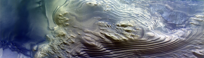
Figure 2. CaSSIS image of a layered mound in Juventae Chasma (2018 October 2, ESA/Roscosmos/CaSSIS, CC BY-SA 3.0 IGO).
Download figure:
Standard image High-resolution image2.3. Resources
Both shallow ground-ice and hydrated mineral deposits are of interest to NASA as potential resources for human missions (e.g., NEX-SAG 2015; MEPAG 2020). Recent work by Piqueux et al. (2019) used data from the Mars Climate Sounder (MCS) and Thermal Emission Imaging System (THEMIS) to derive the depth to the water-ice table within 1 m of the surface. This result and those of the project "Subsurface Water Ice Mapping (SWIM) on Mars," (Putzig et al. 2020) indicate a greater extent of near-surface water ice at lower latitudes than previously mapped. Regional studies and the SWIM project have leveraged multiple data sets in an effort to span the gap between shallow and deep ice detections, but the 5–20 m depth range effectively remains a blind spot for current orbital assets.
Two projects are underway to create global maps of hydrated minerals with data from the Observatoire pour la Minéralogie, l'Eau, les Glaces et l'Activité (OMEGA) and the Compact Reconnaissance Imaging Spectrometer for Mars (CRISM; Riu et al. 2019; Seelos et al. 2019). However, these global maps are at coarse spatial scales and only able to map two-dimensional surface exposures in regions where dust coverage is low. To understand the potential for hydrated minerals as a future resource, both higher spatial resolution spectroscopy and the ability to link subsurface deposits to surface exposures through radar will be important. New orbital data would significantly enhance future science investigations as well as the resource mapping that requires the same information.
3. Science Objectives and Measurements
As noted in the Introduction, our team focused on scientific objectives related to the evolution of Mars as a habitable world. In particular, we crafted two overarching science questions that could be addressed synergistically with a common set of instruments.
- 1.When did elements of the cryosphere form and how are ice deposits linked to the current, recent, and ancient climate?
- 2.How does the crust record the evolution of surface environments and their transition through time?
These two questions lead to eight primary science objectives, four under each question, and their associated measurements as illustrated in Table 2.
Table 2. Science Objectives and Measurements
| Key Question | Science Objective | Measurements |
|---|---|---|
| When did elements of the cryosphere form, and how are ice deposits linked to the current, recent, and ancient climate? | C1. Determine the global distribution and volume of subsurface ice, especially near the surface (1–20 m). | Determine the lateral extent, depth, and volume of water ice, particularly in the midlatitudes. |
| Identify new ice-exposing impact craters. | ||
| C2. Identify the vertical and lateral structure of ice deposits at the poles and midlatitudes. | Measure the shallow subsurface structure of water and CO2 ice in the polar cap and surrounding polar layered deposits (PLD). | |
| Improve surface composition mapping of the ice cap and PLD. | ||
| C3. Record the annual cycling of volatiles and dust between the surface and atmosphere. | Map the seasonal distribution of surface water, dust, and CO2 frost deposition and sublimation. | |
| Monitor scarp avalanches, seasonal cap venting, and other processes that loft material into the lower atmosphere. | ||
| C4. Link ice reservoirs to their formation processes and history. | Use present and new data to identify periodicity in stratigraphic layers and correlate those to climate cycles. | |
| How does the crust record the evolution of surface environments and their transition through time? | E1. Constrain the nature and timing of ancient aqueous deposits and major environmental transitions. | Determine the composition of primary minerals and their alteration products across environments and ages. |
| Investigate fine-scale composition and morphology in ancient terrain, especially aqueous alteration products. | ||
| E2. Observe which intervals in the geologic record preserve environments that were conducive to the possible origin and evolution of life. | Use mineralogy and the inferred pH and temperature of formation as a proxy for clement and/or habitable environmental conditions. | |
| E3. Identify how igneous rocks record the evolution of magmatic sources and crustal modification over time. | Measure compositional and structural changes in volcanic constructs and lava flows. | |
| E4. Observe how modern processes are reshaping the surface today. | Continued observation of dynamic processes such as RSL, gullies, avalanches, new craters. | |
Download table as: ASCIITypeset image
The Science Traceability Matrix (STM) in the full study report links the objectives to physical parameters and the measurement approach (Calvin et al. 2020). As noted in Table 1, these objectives can be achieved with new radar imaging and sounding, infrared spectroscopy at spatial scales better than current observations, and imaging at multiple scales. However, there is a wide trade space in terms of radar center frequency and bandwidth, spectral range and resolution, and imaging spatial scale needed for our stated objectives. The ability to address multiple science objectives within the radar, imaging, and spectroscopy trade space was the topic of detailed discussion and design trades. Section 4 will describe the instrument and design trades and Section 5 the final instrument parameters. The reader is referred to the STM in the final study report (Calvin et al. 2020) for specific requirements that drove the final instrument selections.
4. Instrument and Measurement Trades and Payload
4.1. Radar
Radar sounders have been operating at Mars for over a decade, with MARSIS on Mars Express (Jordan et al. 2009) and SHARAD on MRO (Seu et al. 2007). They have proven to be invaluable assets for probing the subsurface to depths of over 3 km in the polar deposits (Plaut et al. 2007; Phillips et al. 2008), and tens to hundreds of meters in midlatitude ice-rich deposits (Holt et al. 2008; Plaut et al. 2009; Bramson et al. 2015; Stuurman et al. 2016; Petersen et al. 2018) and volcanics (Watters et al. 2007; Carter et al. 2009; Morgan et al. 2015). However, due to the relatively long wavelengths required for such penetration, and the inherently small associated bandwidths, the shallow subsurface (uppermost 10–20 m) remains unresolved.
In addition to higher-resolution sounding, synthetic aperture radar (SAR) imaging is another tool that could be utilized to explore the shallow depths of Mars. Orbiting SAR imagers have mapped Earth (e.g., Elachi et al. 1982; Jordan et al. 1995), Venus (Saunders et al. 1992), our Moon (Raney et al. 2011), and Titan (Stofan et al. 2007), but Mars has not yet had an orbital SAR mission. While sounders are nadir-pointing instruments, generating a profile of surface and subsurface echoes as the radar moves along the orbital path, SAR imagers emit signals from a side-looking radar to generate a swath of images based on the signal reflected by the surface and near-surface. The returned signal imparts information on surface roughness and the composition and structure of the near-surface (Figure 3). In the case of polarimetric SAR (PSAR), the polarization of the returned signal is recorded to place further constraints on the nature of the surface and near-surface scatterers (van Zyl et al. 1987). The polarization ratio for ices is unique; thus, PSAR provides a means to search for ice that is otherwise ambiguous or undetectable by other instruments. This technique has been used to detect ice on Mercury (Slade et al. 1992) and to investigate ice deposits on the Moon (Stacy et al. 1997; Campbell et al. 2003; Spudis et al. 2010). On Mars, similar to the Moon, PSAR can also be expected to constrain the composition through varying dielectric constant and surface roughness, geologic mapping under thick dust mantles, and regolith thickness and distribution (e.g., Cahill et al. 2014; Patterson et al. 2017).

Figure 3. The left side contrasts visible imagery with that obtained using PSAR of the same location on the Moon (Campbell et al. 2014). The right side shows the resolution of submeter-scale layers in the Greenland ice sheet using P-band sounding with callouts showing the high level of detail available in the stratigraphy (Dall et al. 2008).
Download figure:
Standard image High-resolution imageThe radar image resolution is determined by antenna size. Through synthetic aperture processing, each scatterer is sampled multiple times as the radar travels along the orbital path. Leveraging the Doppler shift (among other effects) associated with the variation in the relative velocity of a sampled point and that of the radar's orbit, SAR processing replicates the same azimuth resolution as would be achieved by a substantially larger physical antenna (Elachi 1987). SAR is therefore a useful approach to operating radar on planetary missions. For example, Mini-RF on the Lunar Reconnaissance Orbiter is a C-band (7.14 GHz, 4.2 cm wavelength) and S-band (2.38 GHz, 12.4 cm) imaging SAR that weighed only 15 kg, with a small 1 m2 antenna that provided pixel scales of 7.5 × 15 m (Chin et al. 2007; Raney et al. 2011).
Interferometric SAR (InSAR) utilizes multiple viewing geometries to construct a phase difference map of the surface in order to create a topographic model and to enable the quantification of surface change with subwavelength resolution, typically centimeter-scale displacements for usual SAR frequencies (Gabriel et al. 1989; Burgmann et al. 2000). These multiple geometries can be achieved in a single pass with dual antennas, or in multiple passes with a single antenna. Change detection, afforded through this technique, could include the quantification of seasonal deposits at the poles, either through a series of phase correlations over time with repeat passes, or differencing elevation models produced at intervals. InSAR-derived topography would provide much broader coverage than current imagery-based digital terrain models (DTMs) and could perhaps provide an order of magnitude higher vertical resolution than MOLA (centimeters rather than meters). This would be a major advance for geomorphic studies of potential ice-related features and would also enable clutter simulations for a high-resolution sounder.
Radar sounding at a resolution an order of magnitude higher than SHARAD (i.e., ∼1 m) would be complementary to imaging and ice detection with PSAR/InSAR. Sounding data would provide better constraints on near-surface structure and stratigraphy than PSAR/InSAR, but without the coverage, imaging, or detection of ice through polarimetry. Such sounding could be accomplished at the same central wavelength as SAR imaging, but to enable greater depth of signal penetration, it might ideally be done at frequencies between those of SHARAD and those of an imaging SAR, thus requiring a separate antenna.
Our study examined:
- 1.Wavelength, horizontal resolution, and penetration of PSAR versus InSAR.
- 2.Vertical resolution and total penetration depth tradeoffs for radar sounding.
- 3.Antenna complexity and size for PSAR.
- 4.Antenna complexity, size, and data rates for InSAR, with dual-antenna, single-pass operations, or single-antenna, multipass operations.
- 5.Wavelength, bandwidth, antenna type, and size for radar sounding, including the possibility of using the same frequency as PSAR/InSAR.
- 6.Coverage for InSAR topography and change detection versus operational mode.
- 7.Combined use of an antenna for communications and PSAR/InSAR.
Over the course of our evaluation, it became clear that InSAR at frequencies needed for subsurface penetration would not likely have the ability to vertically resolve seasonal ice and that dual stereo cameras (see Section 4.2.2) would provide higher spatial and vertical resolution topography. Hence, the team ultimately selected the combination of PSAR and sounding with stereo cameras.
As noted above, our ability to map both the global distribution of ice and its horizontal and vertical structure is limited by the coarse resolution of current radar sounders, and the sensing gap between ∼5 and 20 m (Figure 4). To optimize measurements of the ice table in the existing observational gap, our study concluded that both sounding and SAR imaging in the P band (200–450 MHz, 1.5–0.7 m wavelength) are required, ideally at distinct center frequencies. The P band has also been advocated in various past studies (Campbell et al. 2004, 2012; Paillou et al. 2006; Pettinelli et al. 2007; Rincon et al. 2019). By contrast, the higher frequencies of the L band (900–1400 MHz, 33–21 cm) do not penetrate sufficiently to advance the state of knowledge of the depth to subsurface ice reservoirs. As noted in Figure 4, the lower frequencies of the P band would sense directly in the current observation gap for ice and will determine the ice lateral extent, volume, and presence at latitudes nearer the equator where ice is expected to be buried under several meters of dry overburden.

Figure 4. The "SWIM" project integrates data from multiple spacecraft and observations and identifies a sensing gap between ∼5 and 20 m depth (orange horizontal dashed lines). The depth of penetration in icy regolith depends on the radar center frequency as modeled by Pettinelli et al. (2007; black and blue horizontal dashed lines, labeled with center frequency).
Download figure:
Standard image High-resolution imageThe ability to sound and image surfaces covered by dust or regolith will be highly valuable to geologic applications, providing information on buried features, including valley networks and fluvial channels, volcanic flows and ash, and basin fill and other sedimentary deposits. Support for an orbital SAR instrument is demonstrated by Earth-based radar maps of Mars that show tremendous detail in surfaces that are dust covered, illuminating blocky lava flows in the Tharsis region, and deposits from the large outflow channels (e.g., Campbell et al. 2012; Harmon et al. 2012; Harmon et & Nolan 2017)
4.1.1. PSAR and Sounding
The primary MORIE instrument for ice detection and lateral mapping is a full polarization P-band Synthetic Aperture Radar (Polar-SAR). The instrument has a 100 m lateral resolution at the surface and the ability to detect the top of the ice within 3 m of the surface. A spotlight mode and higher data rate can achieve even higher spatial resolution at selected locations. High vertical resolution in ice deposits is obtained using a radar sounder in a higher-frequency range than MARSIS or SHARAD (1.3–5.5 MHz and 20 MHz respectively) with 0.5–1 m vertical resolution in buried ice from 1 to 20 m depth. One outcome of the study was the realization of the feasibility of combining both SAR and sounding, resulting in substantial savings on mass and cost. The P-band sounding/SAR hybrid combines two observational modes into a single instrument. Two sounder center frequencies (200 and 400 MHz) cover different maximum penetration depths, with the higher frequency and higher bandwidth (100 MHz) enabling finer-resolution data at the shallower penetration depths, and the lower frequency probing deeper, particularly in ice-rich zones (∼80–100 m). The SAR data are also used to detect ice in the upper few meters, leveraging the polarization of the returned signal to identify deposits that might not be detected by the sounder.
4.2. Imaging
For MORIE's mission goals, an imager would enable the additional study of ice, particularly as exposed by craters, and data for key hydrous mineral stratigraphic sequences by increasing coverage and spatial resolution. The NEX-SAG report identified high-resolution (HiRISE-class; ∼30 cm/pix or better) optical imaging as a critical capability, which was included as a baseline instrument. However, HiRISE has covered <3% of the Martian surface, and a large imager is both a cost and mass driver. We chose radar as the large instrument with precedence for this mission concept, given the critical nature of the ice-mapping science goal. Additionally, particularly for studies of active processes, there is great value in coordinated targeting and simultaneous data collection at multiple scales from one spacecraft, as shown by MRO with coordinated imaging between CTX and HiRISE. Lower-resolution imaging, as envisioned by ICE-SAG, can expand spatial coverage, which is valuable for tasks such as identifying new ice-exposing craters. NEX-SAG briefly considered ultra-high-resolution (5 cm/pix) optical imaging but noted accommodation challenges and did not examine what could be achieved with a coarser resolution than that of HiRISE.
We considered the following imager trade spaces to determine which instrument parameters best addressed the science objectives and complemented the other instruments under consideration:
- 1.Spatial resolution and coverage
- 2.Stereo capability
- 3.Signal-to-noise ratio
- 4.Wavelength coverage
- 5.Cost and mass
The MORIE study team considered a range of possible instrument pixel scales. After detailed study and image resolution modeling using HiRISE, the 1 m per pixel (1 m/pix) scale was found to be ideal for both observing new ice-exposing craters and doing follow-up analysis without requiring a very large telescope (both a mass and cost driver). In particular, the MORIE imaging strategy combines modest-resolution stereo imagers (CTX scale) for increased spatial coverage, and a 1 m/pix imager (with color) to achieve all imaging goals (Sections 4.2.1 and 4.2.2 below). This combination of instruments at different spatial pixel scales is sufficient to identify ice-exposing impacts as small as a few meters across. This imager complement is also capable of detecting many other forms of surface activity such as recurring slope linea (RSL; e.g., McEwen et al. 2011) or gully flows (e.g., Dundas et al. 2019). A low-cost and low-mass wide-angle imager allows for continued monitoring of weather and seasonal frost.
4.2.1. High-resolution Imaging
MORIE's primary high-resolution camera (C-IMG) is a 1 m/pixel imager that contributes to observing ice-exposing craters and geologic targets. A major new capability that we prioritized for this instrument was multispectral wavelength coverage. Although the High Resolution Stereo Camera (HRSC), HiRISE, and the Colour and Stereo Surface Imaging System (CaSSIS) provide color images in visible channels, only a small fraction of the planet has been imaged in color at these pixel scales. Additional channels at 1 m/pix bridge a critical gap between HiRISE and CRISM in both resolution and spectral information. The spatial resolution will exceed that of CaSSIS (Figure 2) and the camera would have 20 channels covering the visible through near-infrared. C-IMG complements the spectral instruments (Section 4.3) by providing channels in the visible and near-infrared (VNIR), giving a high-resolution context for the detailed mineralogy. Recent advances in detector technology enable a single chip to be used for both optical and near-infrared wavelengths up to 1.7 μm without active cooling. A modern HgCdTe detector can provide multicolor information via a series of filters, similar to the Europa Imaging System (EIS). We found that 20 spectral channels between 0.4 and 1.7 μm wavelength would provide significant mineralogical information relevant to ice, mafic, and alteration minerals and approximate the color filters of HiRISE and CaSSIS, for continuity with those data sets.
Superresolution via oversampling is possible with digital time delay integration (TDI) and can improve the image resolution beyond the native capabilities of the optics (e.g., McEwen et al. 2012; Gao et al. 2017). Carrying out superresolution imaging in flight enables all of the component images to be acquired simultaneously with identical lighting and viewing angles as well as known pixel offsets, improving image reconstruction, and enabling processing to be performed on board the spacecraft. This method enables submeter pixel scales with a smaller, lighter imaging system. This could be achieved either with color TDI lines (at the price of mixed spectral information) or a dedicated chip. Rather than designing a chip layout with offset pixels, a similar effect can be achieved with a slight cross-track motion of the target across the detector (McEwen et al. 2012); this can either be accomplished by spacecraft motion, or a slight "twist" in the installation of a dedicated chip.
4.2.2. Dual Stereo Cameras
To complement the pixel scales of C-IMG and provide wider spatial coverage, the MORIE payload includes dual monochrome cameras (Mid-S-Cam) pointed at a 30° angle to each other for single-pass stereo image acquisition. Stereo capability is required in order to provide high-resolution topography that is critical for better interpretation of the radar data through surface clutter simulation. These cameras are expected to be similar in resolution to the CTX camera on MRO, ∼5 m/pixel. In addition to providing a global high-resolution digital elevation model that will aid in correlating polar stratigraphy to climate cycles (Objective C4 in Table 2), these cameras will also be useful in detecting new ice-exposing impacts in midlatitudes that can then be imaged in higher resolution and color using C-IMG (Objective C1). High-resolution topography will also significantly enhance sedimentary and volcanic sequence stratigraphy (Objectives E1 and E3). For example, concurrent stereo imagery avoids issues of repeat-pass stereo such as changing atmospheric or illumination conditions that restrict stereo reconstructions from the MRO CTX and HiRISE cameras. Using the concurrent stereo technique, HRSC has achieved global topography at 50 m/pixel at a vertical resolution of a few tens of meters (Gwinner et al. 2016). The MORIE system will improve this by an order of magnitude.
4.2.3. Wide-angle Imaging
In order to continue the decades-long record of weather and seasonal frost monitoring that began with the Mars Orbiter Wide Angle Camera (MOC-WA) and continued with the Mars Color Imager (MARCI) on MRO, the MORIE mission includes the Mars Atmosphere and Volatile Resource Investigation Camera (MAVRIC). This wide-angle camera images limb to limb on the dayside in one dozen visible and short-wave infrared (SWIR) bands. The instrument is designed to acquire daily global coverage to characterize seasonal frost, clouds, and dust-storm evolution. SWIR bands discriminate CO2 and H2O frosts, while visible bands discriminate dust and volatile clouds at twice the spatial resolution of MARCI (Objective C3).
4.3. Spectroscopy
The surface of Mars has been measured at a variety of wavelengths and spatial resolutions (Figure 5). The visible, near-infrared, and short-wave infrared (0.4 to ∼5 μm, VNIR/SWIR) and the long-wave (or thermal) infrared (∼5–50 μm, LWIR or TIR) provide complementary information on surface composition. The VNIR/SWIR is most sensitive to iron oxides, oxyhydroxides, as well as anions resulting from high- or low-temperature water-driven alteration and has been widely used on Earth and Mars to identify and discriminate among phyllosilicates, carbonates, sulfates, opal, etc. On Mars, this wavelength range was also crucial to identifying primary minerals such as high- and low-Ca pyroxenes and olivines. The long-wave infrared, in addition to sensing the alteration minerals noted above, is sensitive to bonds of the SiO molecule in varying crystallographic coordinations. All silicates have diagnostic absorption features at LWIR wavelengths and this range is useful for feldspars, quartz, and other common rock-forming minerals that lack strong features at shorter wavelengths. Both wavelength ranges have been used to map the composition and grain size of the Martian ices: water and CO2.

Figure 5. Spectral range and spatial resolution (expressed as m/pixel) of past Mars Orbiter multiband imagers and spectrometers. Color denotes the mission, and the outline, or shape, identifies spectrometers distinct from multispectral imagers. Systems currently operating include HiRISE, CTX, CRISM, and MARCI on MRO, CaSSIS on TGO, HRSC and OMEGA on Mars Express, and THEMIS on Odyssey.
Download figure:
Standard image High-resolution image
LWIR data have also been used to model surface thermal inertia and detect near-surface ice deposits by their thermophysical properties (e.g., Bandfield & Feldman 2008; Piqueux et al. 2019; Sizemore et al. 2020). Comparison of thermal inertia and radar ice detections will allow us to trace the increase in the depth to the ice that is expected from higher to more equatorial latitudes.
Both NEX-SAG and ICE-SAG strawman payloads included a CRISM-like instrument and a THEMIS-like thermal mapper both at improved spatial resolution over current measurements. The best SWIR data are from CRISM at 18 m/pixel, but with sparse coverage (∼2%), and global maps in the SWIR and LWIR are at a few hundred meters/pixel. THEMIS, a multichannel LWIR imager, cannot provide detailed mineralogy and is usually supplemented with data from the Thermal Emission Spectrometer (TES). However, TES had a very coarse spatial resolution (∼3–6 km). TES enabled quantitative petrology of regional igneous compositional variability on Mars (e.g., Rogers & Christensen 2007), but it was insufficient for detecting outcrops of either primary or alteration minerals. Higher spatial resolution LWIR spectroscopy could lead to major advances in our understanding of mineral assemblages on Mars, as LWIR spectroscopy allows for quantification of mineral abundances of both alteration and primary minerals, facilitating the retrieval of more complete mineral assemblages (Feely & Christensen 1999). High spatial resolution LWIR data could also expand and enhance our understanding of the myriad alteration sites identified with CRISM.
Advances from CRISM imaging spectroscopy have demonstrated that high-resolution <20 m/pixel compositional information is required to resolve the details of transitions in mineral assemblages that signal changes in environmental conditions (e.g., Murchie et al. 2009). One way to achieve this increase in spatial resolution is to decrease spectral resolution, as demonstrated by the improved spatial resolution but limited spectral channels of THEMIS (Christensen et al. 2004). At shorter wavelengths, HiRISE, HRSC, and CaSSIS color data demonstrate that the inclusion of infrared multispectral color can reveal compositional variations unobservable at visible wavelengths (e.g., Delamere et al. 2010). This was a major success of the Advanced Spaceborne Thermal Emission and Reflection Radiometer (ASTER) instrument observing Earth with narrow channels concentrated around wavelengths where alteration minerals have numerous absorption features (e.g., Mars 2013).
The most scientifically compelling instrument payload includes multiple spectral instruments, but we conducted a more detailed investigation of this trade space to identify the most effective combination of spectral range/resolution and spatial resolution across SWIR/LWIR wavelength ranges for both environmental transitions and polar ices and stratigraphy. Consequently, our study considered:
- 1.Wavelength ranges and spectral resolution needed to advance information on mineral and ice compositions and abundances over current data sets (Figure 5), including emerging instrument capabilities.
- 2.Instrument suites with different combinations of imaging spectroscopy versus multispectral imaging versus point spectroscopy to obtain high-resolution composition and morphology required for stratigraphic interpretation.
- 3.Whether each instrument required a dedicated telescope.
The final MORIE spectral suite takes advantage of instruments that have flown and those that are being developed for near-term launch opportunities such as the Mapping Imaging Spectrometer for Europa (MISE), Earth Surface Mineral Dust Source Investigation (EMIT), and Polar Radiant Energy in the Far Infrared Experiment (PREFIRE). We gather spectral data from the visible through the thermal infrared using channels from the high-resolution imager (Section 4.2.1) and both short- and long-wavelength infrared spectrometers. A key resource driving factor is not the spectrometer or detectors but rather the telescope(s) to attain high resolution. The SWIR and LWIR spectrometers have similar telescope requirements in terms of diffraction and signal-to-noise ratio. Another result of our study was the ability to use a beam splitter to allow the instruments to share a telescope and reduce overall mass while still achieving the desired spatial resolution in both SWIR and LWIR.
4.3.1. Short-wave Infrared
The MORIE payload would include a Next Generation Short Wave Imaging Spectrometer (NGSWIS) for detailed mapping of both alteration and primary mineralogy. This 1.3–4.2 μm spectrometer has heritage from the JPL Dyson spectrometer design used for EMIT and MISE, and can provide a spectral sampling of <10 nm, and spatial resolution of 5 m, with a swath of 6 km. The instrument collects targeted observations of high-priority sites. NGSWIS will map alteration mineralogy at spatial scales that are a factor of 3 better than the best observations from CRISM. Finer spectral resolution will allow us to distinguish among many alteration minerals, including solid solution series with sufficient spatial resolution to understand evaporative sequences.
4.3.2. Long-wave Infrared
Long-wavelength infrared (LWIR) spectroscopy is required for igneous petrology and minerals not detectable at shorter wavelengths. The MORIE Mars Far Infrared Emission (Mars-FIRE) imager has heritage from PREFIRE using a grating for dispersion and uncooled microthermopile arrays. The design achieves a spectral range from 6 to 25 μm in at least 20 channels with <1 μm bandpass, and <100 m spatial resolution. This instrument will provide quantitative mineral abundance maps of igneous compositions with spectral fidelity and mineral discrimination similar to TES, but with a significantly improved footprint (equivalent to THEMIS), revolutionizing our understanding of the primary mineralogy. These data will also support ground-ice mapping through the determination of the surface thermal inertia.
5. Final Mission Scenario
We give a brief summary of the MORIE mission here; we refer readers to the final MORIE report (Calvin et al. 2020) for additional detail. The final MORIE payload and planned specifications are noted in Table 3.
Table 3. MORIE Payload
| Instrument | Description | Center Freq or Range | Spatial Sampling at Nadir | Acquisition Mode | Science Objectives (Table 2) |
|---|---|---|---|---|---|
| Polar-SAR | Full polarization synthetic aperture radar | 400 MHz | 100 m, sense ice within 3 m of the surface | Continuous nightside | C1, C2, E3, supports E1, E2 |
| RaSo | Radar Sounder | 400 & 200 MHz | 2 km, 0.5 to 1 m vertical resolution in ice | Continuous nightside | C1, C2, C4, supports E1, E3 |
| C-IMG | High-resolution Color Imager | 0.4 to 1.7 μm in 20 channels | 1 m/pixel | Dayside, selected targets | C2-C4; E1-E4; supports C1 |
| NGSWIS | Next Generation Short Wave Infrared Imaging Spectrometer | 1.3 to 4.2 μm, at <10 nm spectral resolution | <5 m/pixel | Dayside, selected targets | E1-E3; supports C1, C3 |
| Mars-FIRE | Mars Far Infrared Emission Imager | 6 to 25 μm in 20 channels, <1 μm bandpass | <100 m/pixel | Day and nightside selected targets | E1-E3; supports C1, C3 |
| MAVRIC | Mars Atmosphere Volatile and Resource Investigation Camera | 0.4 to 1.7 μm in 6 VNIR and 6 SWIR channels | 0.5 km/pixel | Continuous dayside | C3, supports E4 |
| Mid-S-Cam | Dual Monochrome Cameras | Pan | 5 m/pixel | Continuous dayside | C2, supports C1, C4 |
Download table as: ASCIITypeset image
MORIE is enabled by a solar-electric propulsion (SEP) powered spacecraft. We baselined a 2026 launch, requiring ∼2 yr to cruise to Mars and spiral down into a 3 PM equator-crossing Sun-synchronous orbit with an inclination of 92 7. Note that this 2026 launch is for illustration, and suitable opportunities recur regularly. The spacecraft spends a full Mars year in this orbit, then transitions to a 90° true-polar orbit to enable direct radar sounding of previously unobserved regions of the polar caps. This closes the current nadir sounding gap from ∼87° latitude to the pole, both north and south. The mission then spends one Mars year in the polar orbit before transitioning back to being Sun synchronous for an extended mission or communication relay activities. The SEP-orbiter is characterized by a large 6 m deployable SAR antenna, two flexible solar arrays, and an articulated 3 m high-gain antenna. The SEP thrusters drive the power requirement, leading to 43 m2 solar arrays that also provide ample power to run the radar and telecommunications system in orbit. The design does not present any major technical challenges or novel risks.
Data downlink rates are strongly dependent on the Earth–Mars distance and are estimated from 3 to 75 Mbps for 2.5 to 0.5 au. Using a midrange average of 280 Gbits/day, MORIE will generate >300 Tb of downlink during the two Mars-year mission, or 12× the MRO data return over a comparable period. The SAR, radar sounder and stereo monochrome imagers will build global maps over the life of the mission. The high-resolution color imager and spectrometers will acquire >50,000 targeted observations. The development of new technologies such as optical communication or advanced onboard data processing could substantially enhance targeted data volume. The team costed both the full mission and, due to the recent programmatic interest in a Mars Ice Mapper, an ice-focused radar version. Cost models using $FY25 and 50% reserves, the guidelines provided for the PMCS, suggest the full mission point design is $1.4 billion, $0.3 billion above the FY25 New Frontiers cost cap of $1.1 billion. The ice-focused mission is below this cap. However, with instrument or hardware contributions or further design maturity, costs for the full mission may be achievable within New Frontiers. For example, modular designs under development for the P-band radar could substantially reduce the mass and power requirements for the radar (Rincon et al. 2019).
6. Potential for New Science
Water is the key to present and past habitability on Mars. MORIE would address key questions linked to water—where it is today, where it was, and how it has modified the surface through time. Specifically, the mission would determine the lateral extent and volume of subsurface water ice as well as the nature and timing of transitions between ancient aqueous environments using radar, imaging, and spectral observations. MORIE observations would include the first radar imaging from orbit, the first radar sounding directly over the poles, and surface mineral mapping at unprecedented spatial scales. MORIE radar would resolve depths and near-surface stratigraphy in ice that are currently unobservable, allowing the full Mars subsurface ice inventory to be mapped and quantified. High spatial resolution spectral instruments will detect minerals at spatial scales that are 3 to 60 times better than current orbital instruments, unlocking the evolutionary sequence of environmental transitions that are crucial to understanding the evolution of the nearest habitable planet.
This work was supported by NASA grant #80NSSC20K0578 to UC Berkeley for the MORIE and MOSAIC Planetary Mission Concept Studies. We appreciate the technical and engineering support provided by Steve Matousek, Nathan Barba, Ryan Wooley, and Cassie Stuurman as the main technical leads at JPL and acknowledge the many other individuals who participated in this study as cited in the final report. The manuscript benefited from internal review through the USGS from Janet Ritchie and Laz Kestay, and two anonymous reviews from AAS. We appreciate their time and opportunity to improve the manuscript's clarity and content.