

Abstract
Soil loss is a challenge for sustainable river management, not the least in the Mediterranean region, with climate extremes altering erosion and overland sediment transport. The dynamics of these processes, and their ecological consequences, are poorly documented in the Mediterranen region. For the Arno River Basin (ARB), located by the Tyrrhenian coast of Italy, we estimated changes in annual sediment discharge (SD) as a function of the landscape characteristics within the basin, the seasonal distribution of precipitation and flooding, and the vegetation cover. Owing to a semi-empirical modelling framework, we identified critical erosion-/deposition-prone periods from 1500 to 2019 CE. The long-term estimated mean gross soil erosion in the ARB was ∼900 Mg km−2 yr−1, whereas mean net erosion was ∼200 Mg km−2 yr−1. The results revealed that during the Little Ice Age (ending ∼1850 CE), increased storms and SD had a large impact on the landscape and agricultural activity of the ARB. The downward trend in SD observed after ∼1903 CE occurred with high soil movement, along with environmental change and basin reforestation. The basin area thus experienced, on average, only slight soil losses, with ∼76% of the eroded soil being trapped along the stream reaches, on gently sloping areas as well as in the foot slopes and the valley terrains which divide the basin area. Relying on credible information regarding SD and its hydrological drivers, we showed how historical climatology and parsimonious modelling can be implemented to obtain basin-wide estimates of soil loss, and are appropriate tools for sustainable river basin management.
Export citation and abstract BibTeX RIS

Original content from this work may be used under the terms of the Creative Commons Attribution 4.0 licence. Any further distribution of this work must maintain attribution to the author(s) and the title of the work, journal citation and DOI.
1. Introduction
The transition from hunting and gathering to farming, beginning ∼11,000 years ago, has made humans increasingly reliant on agriculture and, with it, increasing rates of soil erosion, which occurred distinctly in many areas between 3000 and 1000 years ago [1]. Today, storm- and runoff-driven soil erosion and sediment losses cause major, widespread environmental degradation worldwide [2]. A decrease in agricultural productivity due to the removal of fertile topsoil is one of the main consequences of watershed sediment dynamics, which may require the improvement of drainage systems for flood management [3] and demand a transition to more sustainable practices in rural districts [4].
These are the concerns that motivated this study, which addresses the current knowledge gap on the role of soil loss drivers and the use of this knowledge to limit sediment yield and improve land management. Of key importance in this context is climate, which is the most active forcing agent of soil erosion. It reshapes the spatial distribution of flows (with hierarchical interaction of landscape units) and the temporal distribution of damaging hydrological extreme events (with centennial to millennial recurrence times), that strongly affect storm-erosivity patterns [5] Historical memory is not sufficient to protect human settlements from the consequences of altered hydrological regimes [6]. Thorough research and better reconstruction of changes in land degradation due to storms and erosion, as well as the underlying driving mechanisms, are essential steps to predict these changes and improve adaptation strategies. Thus, understanding how climate extremes and vegetation cover limit and influence geomorphological and biological responses at the basin level is a challenge, not only to model soil erosion and sediment, but also to reconstruct related hazards over centuries [7, 8]. Together with climate, human activity (mainly vegetation patterns and other land uses) has also played a key role in the mobilisation and transfer of sediments in river basins.
The empirical observations of Leonardo da Vinci (1452–1519) have shown this in historical times. In his Trattato sull'acqua ('Treatise on Water'), published in 1489, he wrote (Cardinali, 1828 [9], p. 401):
Pi ù terreno lasciano li fiumi, dove sono vicini li popoli, che di dove non è specie umana, perchè in tali luoghi li lavorano li monti, e li colli, e le piogge portano via il terreno rimosso con pi ù facilità, che li terreni duri, e coperti di varie cose.
The sediment of the rivers are more abundant in areas that are densely populated, where the places the mountains and hillslopes are tilled and the rain sweeps away more easily a ploughed soil than a soil that is hard and covered by vegetation (our translation).
Later, in 1503 CE, Leonardo da Vinci wrote (Curti, 1979 [10], p. 40):
L'irregolarità nella portata delle acque dell'Arno e la loro tendenza a modificare continuamente il letto del fiume trasportando nuovi sedimenti
The irregularity in the flow of the Arno's waters and their tendency to continuously modify the river bed carrying new sediments (our translation).
However, it is not easy to disentangle climate- from human-induced changes in soil erosion, as these two control factors are often interlinked and sediment dynamics can only be explained by an interplay between them [11]. With progresses in hydrological modelling, scientists have developed empirical [12] and physical models [13–15] to explain these competing factors at different spatial and temporal scales. However, quantifying and predicting the impacts of soil erosion on landscapes remain significant challenges still today as they require an in-depth understanding of the dynamics of climate extremes [16]. This is also due to the limited availability of historical time-series of floods [17] and sediment erosion [18], for which a qualitative hazard classification methodology based on expert judgement has to be considered [19]. Some recent studies [20–22] have addressed soil erosion dynamics and geomorphological effectiveness in the Arno River Basin (ARB), which is the focus of this article, over the course of the 20th centrury. However, the landscape of Italy, and of the ARB in particular, has been shaped by alluvial events and consequent sediment discharges that have influenced human life in the basin since at least the Middle Ages, including the main city (Florence) and the surrounding countryside [23]. Over this time, the economic and social life of the basin has gradually evolved in contact with the river (figure 1(a)), from which Florence had to defend itself by raising the walls (figure 1(b)).
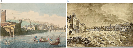
Figure 1. Overview of Florence landscape with the city under diluvial storms. (a), View of Florence and its river from the Veduta di una parte di Firenze presa di fuori della Porta alla Croce presso al fiume Arno printed in 1744–1751 CE by Giuseppe Zocchi (1711–1767 CE) (from https://fondazioneadacullinomarcori.com/portfolio_page/a-view-of-florence-taken-from-above-the-bridge-called-rubaconte/, authorized by © Fondazione Ada Cullino Marcori kept at the Fondazione Spadolini Nuova Antologia). (b), The flood of the Arno river on November 4, 1844 in a lithography of Antonio Muzzi (1815–1894 CE) and Odoardo Borrani (1833–1905) (Retrieved 10:07, June 11, 2021 from https://commons.wikimedia.org/w/index.php?title=File:Cento_vedute_di_Firenze_antica,_1789_(page_197_crop).jpg&oldid=488979203) (b).
Download figure:
Standard image High-resolution imageIn this article, we represent the basin-wide landscape in order to estimate how the ARB has responded to combined changes in climate, and land cover and use, since 1500 CE. Centrally located in the Mediterranean basin, Italy is exposed to soil erosion (figure 2(a)) and, within Italy, the ARB is even more exposed to aggressive rains (figure 2(b)). Here, highly erosive rainfall can occur in late summer and early autumn, while in winter and spring runoff predominates, which can cause considerable soil loss from arable lands and, in turn, the delivery of sediment to the coastal zone [24]. Combinations of gradual and sudden seasonal changes in precipitation systems [25] include unevenly distributed erosive storms [26] and floods [27].

Figure 2. Study area and environmental setting. (a), Mean soil loss rates in the central Mediterranean area (from Panagos et al [24]). (b), Spatial pattern of rainfall erosivity on the Arno River Basin (black square) over the period 1994–2013 CE (from Borrelli et al [28]). (c), Focus on the Arno watershed and its topography, with the city of Florence and the outlet station of Pisa (43° 40' N, 10° 16' E) where the sediment discharge was measured (from Opendata Network—Nodo Autorità di Bacino del Fiume Arno, http://www.adbarno.it/adb/?page_id=833).
Download figure:
Standard image High-resolution imageFigure 2(c) maps the Arno watershed with its seven sub-basins (red curves), the city of Florence and the basin outlet (Pisa's discharge site) where sediment was measured from 1954 to 1990 CE [29]. The difficulties of research on historical sediment dynamics arise from the complex, interacting and nonlinear nature of the relationships between storm and soil erosion. However, extended precipitation time-series derived from historical documentary data help relate regional and sub-regional extremes to impacts [30] in order to assess hydroclimatic forcing [31] and recognise environmental changes in areas exposed to erosive rains [32].
The objective of the present study has been to capture the multiple factors of a changing environment (including climate, vegetation cover and erosive-resistance changes) with available data. In doing so, we sought to study changes in sediment discharge (SD) and its environmental drivers in a Mediterranean river landscape. With focus on the ARB, we developed a monthly-based parsimonious SD model based on rainfall erosivity, winter precipitation, storm severity and woody vegetation inputs. Our integrative methodology incorporates basin-wide experimental hydrological data into a regression-derived SD model. This resulted in a long time-series of input data (1500–2019 CE) for the parsimonious model, which offered a unique opportunity to explore geomorphological processes in the ARB.
2. Results and discussion
2.1. Model calibration and validation
The Sediment Discharge Model (SEDIMARB)—equation (1)—summarises, through mean areal rainfall erosivity, winter precipitation amount, monthly storm-severity index values (MSSI), and woody vegetation inputs, the relationship between temporal patterns of climate and SD, consistent with a sample (1954–1984 CE) of annual observation data (see Material and Methods in the Supplement (available online at stacks.iop.org/ERC/3/071002/mmedia)). For the calibration period 1954–1984 CE, we obtained the coefficients A = 5.162628·10−4 MJ mm−1 hm−2 h−1 yr−1, α = 1.00 Mg MJ−1 mm−1 h, β = 0.10 Mg MJ−1 mm−1 h, φ = 2.80 Mg km−1 mm−1 yr−1 and σ = 1.00 Mg km−1 mm−1 yr−1 in Eqs. (1), (2) and (3). There is no indication of marginal serial correlation in the residuals (Durbin-Watson statistic p > 0.05) and a significant relationship exists between observed and predicted values according to the ANOVA test (p < 0.05). The data-points are aligned within 95% prediction bounds, with negligible differences from the theoretical 1:1 line, except for one data-point (not shown). Taking out the 1955 CE outlier of 140 kg s−1 (∼3% of the dataset of 31 years), not considered for model calibration, we obtained an annual mean value of 42.8 ± 27.4 kg s−1 over the study period, which is close to the mean of actual SD data (42.8 ± 29.2 kg s−1). The regression line has an intercept a = −0.06 (±3.43) kg s−1 and slope b∼1.00 (±0.07), near the optimum values (a = 0 kg s−1 and b = 1). The Nash–Sutcliffe efficiency value equal to 0.89 indicates limited uncertainty in model estimates. The R2 statistic equal to 0.88 means that the model explains 88% of the variability in actual SD data (figure 3(a)). The mean absolute error (MAE), equal to 7.5 kg s−1, is lower than the standard deviation of the residuals (10.0 kg s−1). In addition, MAPE (mean absolute percent error) equal to 25% and Kling-Gupta Efficiency (KGE) equal to 0.92 indicate satisfactory model performance and efficiency. F-ratios were highly significant for each independent variable, the highest p-value being 2.26·10–5 for the term related to the BGE component.
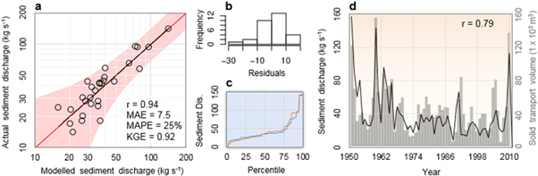
Figure 3. SEdiment DIscharge Model (SEDIM) calibration and validation. (a), Scatter-plot and regression line (dotted black line) of modelled, equation (1), versus actual sediment discharge (in kg s-1) estimated over the Arno River Basin for the period 1954–1990 CE, with the inner (power pink area) and outer (light pink area) bounds showing 90% and 95% confidence limits, and identity line (red line). (b), Histogram of residuals. (c), Percentiles patterns of observed (blue curve) and modelled (orange curve) sediment discharge. (d), Co-evolution of modelled annual sediment discharge (black curve) and solid transport volumes (grey histogram) at the mouth of the river Arno, derived from Monti and Rapetti [29], for the 1951–2010 CE period.
Download figure:
Standard image High-resolution imageFigure 3(b) indicates the normal approximation of model residuals (normality test p > 0.05). The distribution of the percentiles of modelled SD (figure 3(c), orange curve) approaches the distributional shape of the observed erosivity, indicating a satisfactory prediction over the range of erosivity values (including low and high values). Figure 3(d) presents an indirect validation of the model, obtained by comparing the predicted SD with the observed soil sediment volume at the outlet of the ARB over the period 1951–2010 CE. This independent validation (extending over a longer time span than the calibration period) shows that the model follows fairly well (r = 0.79) the temporal pattern of erosional sediment processes occurring in the ARB (figure 3(d)).
2.2. Sediment discharge reconstruction
We know from historical documentary sources that the ARB has always been subject to seasonal erosional changes due to its markedly torrential morphological nature. During intense or long-duration storms, the river has often produced marked fluctuations in runoff and floods and, in turn, sediment delivery. Sometimes, sediment was produced in large quantity, depending on the hydroclimatic forcing and the landscape structures that resisted to storm forcing (see Material and Methods in the Supplement).
Figure 4 shows the estimated time-series of SD with some related environmental changes, dating back to 1500 CE. The long-term fluctuations of the erosional activity determined in a lacustrine area of central Italy (42° 12' N, 12° 57' E) are in general agreement (figure 4(a)) with our reconstructed time-series of SD. In particular, until the middle of the 17th century, the SD time-series of the ARB had frequent low-erosion storm, with ∼110 kg s−1 occurring once every two years (figure 4(d)). SD values of ∼370 kg s−1 are present only once every 20–30 years (i.e., in the years 1515, 1532, 1547, 1571, 1589, and 1646 CE). The maximum value, 1905 kg s−1, occurred in the year 1758 CE. Historical documents show that in the 14th and 15th centuries, the Arno riverbed underwent an unsafe uplift due to sediments that continued to settle and that the presence of bridges, locks and barriers ended up constantly favouring [33]. Thus, since the end of the 17th century SD has often become livelier, with annual values that are more frequently >300 kg s−1 (about once every two years), while the values once expected every 20–30 years have increased strongly to 608 kg s−1. The values of 1423, 1905, 873 and 868 kg s−1 (which occurred in 1688, 1758, 1805, and 1868 CE, respectively) are considerably high, as they are SD estimates for the entire basin area. This means that even higher SD values may have occurred widely within the basin, leading to continuous discharge of sediments until the 19th century. According to Rossini (1855 [34], p. 27): Miglior ventura non dovette correre in altri tempi la valle superiore ed inferiore dell'Arno, nè pi ù prospera fu concessa alle nostre terre e paesi da quell'epoca (1761) fino a noi, benchè di continuo fossero praticati nell'Arno dei ripari considerevoli, poichè per la copia delle acque sempre crescente [...] vengono facilitate spesso le erosioni ed i trabocchi ('The upper and lower valley of the Arno did not have to run better in other times, nor more prosperous was it granted to our lands and villages from that time (1761) up to us, although considerable shelters were continuously practiced in the Arno, as for the ever-increasing copiousness of the waters [...] erosions and overflows are often facilitated'). Even if SD values have not increased in the ARB during the 20th century (figure 4(d)), gross erosion (GE), which represents soil movement in the basin, has in recent years reached remarkably high rates (figure 4(c)) of 2163, 1849, 1795 and 2150 Mg km−2 yr−1. These values, estimated in 1951, 1960, 2010 and 2014 CE, respectively, are comparable to those of the Little Ice Age (LIA; ∼1300–1850 CE), and exceed the soil loss tolerance of ∼500–1000 (Mg km−2 yr−1) [35, 36].

Figure 4. Precipitation patterns in the Arno River Basin and central Italy. (a), Reconstruction of erosional activity in Lake Turano, central Italy (from Walsh et al [11]). (b), Evolution of reconstructed woody area (green band) and main land-use (with arrows indicating the dates at which changes in woody vegetation cover are known) across the Arno River Basin. (c), Time-series of estimated gross erosion (orange curve). (d), Time-series of estimated—Eq. (1)—sediment discharge (black curve), with over-imposed 98th percentile values (light, horizontal white lines), before and after the two change-points at 1740 and 1903 CE (red narrow). The y-axis in (c) and (d) are in log-scales.
Download figure:
Standard image High-resolution image
Significant change-points in the SD time-series were detected in 1740 (SNHT-double shift), in the central part of the LIA, and in 1903 (SNHT-double shift and Mann-Whitney-Pettitt test), at the onset of modern warming (red arrows in figure 4(d)). The second change-point in the estimated SD time-series mainly coincides with a low erosive forcing during a landscape restoration, confirmed by the reforestation of the basin in the decades after 1903 CE. An earlier change-point, in the year 1687 CE, was detected in the GE time-series (figure 4(c), orange curve) with the SNHT-double shift (not shown). In fact, more frequent and severe hydrological events occurred in Italy at the turning point of the 17th and 18th centuries [27], approximately during the so-called Maunder Minimum, which began c. 1645 CE and lasted until c. 1715 CE, a period characterised by extremely rare sunspots and mostly below-average temperatures even for the LIA [37]. After GE values peaked at the end of the 17th century, there has been a continuous decline until the end of the 19th century. Then, GE increased again significantly throughout the 20th century (Mann-Kendall test p < 0.01), in a similar way as it had done in the central part of the LIA.
The difference between gross and net erosion (B = GE–NE) is a sink term representing the fraction of GE stored in the basin during the re-sedimentation process. The term B is derived from the sediment delivery ratio (SDR), also known as the connectivity ratio [38], which describes the extent to which eroded sediments are stored within the basin: B = (1– SDR)·GE [39]. In this way, the amount of sediment that reaches a stream over the amount of eroded soil characterises the efficiency of the slope-to-channel transfer, depending on the transport capacity, which in turn is modified by the effects of the slope shape and drainage pattern. The average long-term estimate of B for the ARB is 690 Mg km−2 yr−1, with SDR = 0.24. This estimate is higher than 44 to 235 Mg km−2 yr−1 reported for Alpine basins [40], with comparable values of the SDR (from 0.27 to 0.48). This indicates that high amounts of soil are mobilized in the ARB (on average, GE = 905 Mg km−2 yr−1) due to erosion in mountain ranges (which only lie along the northwestern margin of the basin; figure 2(c)) but a relatively high fraction is retained in the Marshy areas of the basin, which are large reservoirs for the collection of flood water and sediments.
At a time when the extension of pastures and an extensive cultivation of ploughed areas at the expense of forest was planned (figure 4(b)), a strong erosive forcing likely caused the incessant expulsion of tree stands and strong rainwater runoff that washed the fertile soil in the plains, causing the land to rise in the river valley, as had happened in the 14th and 16th centuries [41, 42]. This is confirmed by the forestry legislation of Tuscany during the time of the Medici family (1434–1737 CE), in which (our translation) 'renovations were all aimed at avoiding the washout of the Apennine slopes and the transport of earth debris downstream, causes of the progressive rise of the bed and mouth of the Arno and the potential swamping of the plains along the course of the river' (rinnovazioni tesero tutte ad evitare il dilavamento delle pendici appenniniche ed il trasporto a valle dei detriti terrosi, cause del progressivo innalzamento del letto e della foce dell'Arno e del potenziale impaludamento delle pianure lungo il corso del fiume; Belli, 1998 [43], p. 127).
The origin of this instability has not only been climatic, but has often been favoured by repeated and excessive exploitation of forest resources in the high hills and mountain areas to meet the growing demand for firewood, but has sometimes turned into real deforestation due also to the growing demand for agricultural and grazing areas [44], as shown by historical representations of the landscape around Florence. It is precisely during the 18th century that the ARB became most vulnerable, being subject to agro-forestry activities and deforestation [41, 45]. It is not a coincidence that the climate in the central and final parts of the LIA has provided some damaging scenarios, with storms of unprecedented strength. In particular, the most striking group of erosive events occurred between the end of the 17th century and the end of the 18th century, when the ARB experienced frequent high erosivity values of ∼2000 (MJ mm hm−2 h−1 yr−1) [46]. Also recently this climatic phase has been identified as erosive, characterised by heavy runoff in the southern Carpathians [47] and flooding at most European sites [17].
Subsequently, the water of the river cleared again when turbidity levels dropped suddenly during the 20th century and have remained low until present. This was mainly due to a major change in land management policy after about 1850 CE, which promoted the reforestation of large mountain areas, the stabilization of mountain slopes and river banks, and the construction of dams and other retention systems [48]. However, sustained GE rates have also been maintained in the recent period. This is evident from figure 4(c) (blue curve), which shows a significant increase of extreme erosion values after ∼1900 CE. This is consistent with an intensification of the geo-hydrological hazard over the past five decades for the inner hilly areas of central Italy [49].
The hazard increase associated with water soil erosion in the basin indicates an interruption of high GE rates, together with a decrease in NE rates and, consequently, a decrease in SD values. During recent decades, for instance, there has been in the ARB a decrease in total precipitation with a significant decrease in the frequency of winter rainy days, while there has been an increase in extreme precipitation over short (one to three hours) time-scales [50]. If this was reported for the ARB, there has essentially been an absence of trends in the intensity of extreme events in the whole of Tuscany [51]. This reflects the data presented here, which show a decrease in long-distance solid transport associated with long precipitation events, and a substantial levelling, or weak rise, of erosion rates associated with short-distance soil movement in the basin, typical of heavy but short-duration rainfall. According to Brandolini et al [52], the degradation of slopes in Tuscany can be linked to the intensive management of cultivated lands and the increase in hazardous rainfall, which favour the acceleration of erosion processes. We highlight that to restore the sustainability of intensively managed land, the rural parts of the ARB should plan for the incorporation of hedges and trees in agricultural areas, thereby improving the hydrological and structural characteristics of the landscape (and limiting soil erosion in sub-basins) so as to increase soil fertility and, together with it, agricultural productivity.
3. Conclusion
For the entire period assessed (1500–2019 CE), the main results can be summarized as follows:
- 1.SD in the ARB since 1500 CE shows an alternation of long periods of predominantly erosional and depositional processes, with a change-point towards the early 18th century (c. 1740 CE) after which a particularly erosional period appears and continues until the 19th century.
- 2.The second half of the Little Ice Age (from mid-17th to mid-19th century) is followed by a decline in sediment exports.
- 3.The depositional processes were interrupted by the resumption of the erosional processes in the most recent decades (increasing after c. 1903 CE) due to more erosive rainfall, with still limited SD because extended wooded areas that are part of the character of the basin form a barrier to vehiculate soil particles into the stream.
Offering new insights into basin-wide hydro-climate and human history over the past five centuries (1500–2019 CE), this study provides distinct perspectives to continue the effort towards a better understanding of soil loss rates and factors which can enhance or delay soil loss for a sustainable management of the rural landscape. This sustainability can be activated in a basin area with a developed hydrographic network such as the ARB, where the maintenance and enhancement of mountain reforestation and the planned inclusion of hedges and arboretums in lower and flatter areas improve environmental management, reducing soil erosion and, at the same time, increasing soil fertility and agricultural productivity. This requires the need for natural equipment in the development of hydrological plans, taking into account agricultural needs. In particular, hedges can play an important role in the sustainable management of rural areas in the basin by improving hydrological and structural characteristics so as to limit soil erosion in each sub-basin. The parsimonious approach developed in this study for the ARB can potentially be suitable for modelling applications in other parts of the Mediterranean region, provided that model parameters and inputs are documented for these fluvial basins. The natural evolution of this study is the continuation of research with historical datasets on other Mediterranean river landscapes. The Tiber River Basin (central Italy), in particular, is home to a rich documentary heritage [53] that could be exploited to investigate the multi-centennial dynamics of hydrological and geomorphological processes.
Acknowledgments
F.C.L. was supported by the Swedish Research Council (Vetenskapsrådet, Grant No. 2018-01272), and conducted most of the work with this article as a Pro Futura Scientia XIII Fellow funded by the Swedish Collegium for Advanced Study through Riksbankens Jubileumsfond.
Certain images in this publication have been obtained by the author(s) from the Wikimedia website, where they were made available under a Creative Commons licence or stated to be in the public domain. Please see individual figure captions in this publication for details. To the extent that the law allows, IOP Publishing disclaim any liability that any person may suffer as a result of accessing, using or forwarding the image(s). Any reuse rights should be checked and permission should be sought if necessary from Wikimedia and/or the copyright owner (as appropriate) before using or forwarding the image(s).
Data availability statement
All data that support the findings of this study are included within the article (and any supplementary files).
Data availability
The full set of raw data and the equations that support the findings of this study are available in the supplementary file 'S1—Diodato Sediment Discharge Arno'.
Competing interests
The authors declare no competing interests.
Supplementary data S1_Diodato_Sediment_Discharge_Arno.xls