


Abstract
Milldams and their legacies have significantly influenced fluvial processes and geomorphology. However, less is known about their effects on riparian zone hydrology, biogeochemistry, and water quality. Here, we discuss the potential effects of existing and breached milldams on riparian nitrogen (N) processing through multiple competing hypotheses and observations from complementary studies. Competing hypotheses characterize riparian zone processes that remove (sink) or release (source) N. Elevated groundwater levels and reducing soil conditions upstream of milldams suggest that riparian zones above dams could be hotspots for N removal via denitrification and plant N uptake. On the other hand, dam removals and subsequent drops in stream and riparian groundwater levels result in drained, oxic soils which could increase soil nitrification and decrease riparian plant uptake due to groundwater bypassing the root zone. Whether dam removals would result in a net increase or decrease of N in riparian groundwaters is unknown and needs to be investigated. While nitrification, denitrification, and plant N uptake have typically received the most attention in riparian studies, other N cycle processes such as dissimilatory nitrate reduction to ammonium (DNRA) need to be considered. We also propose a novel concept of riparian discontinuum, which highlights the hydrologic and biogeochemical discontinuities introduced in riparian zones by anthropogenic structures such as milldams. Understanding and quantifying how milldams and similar structures influence the net source or sink behavior of riparian zones is urgently needed for guiding watershed management practices and for informed decision making with regard to dam removals.
Export citation and abstract BibTeX RIS
1. Introduction
We are in the age of humans, the Anthropocene (Ruddiman 2013). Human imprints are evident on all spheres of planet earth—the atmosphere, geosphere, hydrosphere, and biosphere. One prime example of such an anthropogenic imprint is the effect of historic milldams and other low-head impoundments on rivers and streams worldwide and especially across the US and Europe (Walter and Merritts 2008, Florek et al 2015, Poeppl et al 2015, Barraud 2017, Brown et al 2018, Fajer and Rzetala 2018, Wohl 2019). Starting with the arrival of European settlers in the 1600s, thousands of milldams were constructed for water power, every 2–5 km, on streams and rivers across the eastern US (Walter and Merritts 2008). Census data indicated that there were >65 000 water-powered mills in the eastern US by 1840 (Walter and Merritts 2008). These milldams coupled with historic erosion following land clearing and agriculture (Happ 1945, Costa 1975, Trimble 1985) resulted in large-scale accumulation of legacy sediments (James 2013) in the valley-bottoms of eastern US streams (Merritts et al 2011, 2013, and supplementary figures S1 and S2 (available online at stacks.iop.org/ERL/16/035016/mmedia)). Many of these milldams have since breached (e.g. figure 1) or been removed resulting in highly incised contemporary streams with exposed vertical streambanks that are vulnerable to erosion (Walter and Merritts 2008, Pizzuto and O'Neal 2009, Merritts et al 2011, 2013, Wegmann et al 2012).

Figure 1. Hollingworth/Evans milldam (1723, ∼4 m) and later Elk River Electric Supply Co. on Big Elk Creek, Cecil County, Maryland in 1909 (left; courtesy Mike Dixon and Historical Society of Cecil County). The same site and similar view in 2018 long after the dam breached in the mid-1900s (right). Portions of dam wall and covered bridge abutment are indicated with yellow arrows.
Download figure:
Standard image High-resolution imageWhile most historic milldams are gone, many still exist with well over 14 000 extant dams documented in the mid-Atlantic and northeast US alone (Martin and Apse 2011). These existing structures are now being removed at an increasing rate (Bellmore et al 2017, Foley et al 2017). More than 1490 dams have been removed since 1912 with 86 removed in 2017 alone (American Rivers 2020). Dam removal rate is highest in the state of Pennsylvania with 267 recorded dam removals since 1912, 10 in 2016, and 14 in 2017 (Bellmore et al 2017, American Rivers 2020). Removal numbers could be higher since not all dam removals or breaches, particularly the smaller ones (<7 m height), are recorded (Magilligan et al 2017, Brewitt and Colwyn 2019). Dam removals are being driven by needs for public safety, reduction in financial liability, recreational access, aesthetics, and/or improvement in fish habitat (Hart and Poff 2002, Pohl 2002, Tullos et al 2016, Foley et al 2017).
To date, much of the research related to milldams and their removals has focused on their effects on stream and fluvial geomorphology (Pizzuto 2002, Merritts et al 2011, 2013, Donovan et al 2015, 2016, Miller et al 2019); the storage, erosion, transport, and export of legacy sediments (Gellis et al 2017, Cashman et al 2018, Gellis and Gorman Sanisaca 2018, Inamdar et al 2018, 2020, Jiang et al 2020, Lutgen et al 2020); and the fate of instream sediments and contaminants following dam removals (Hart and Poff 2002, Stanley and Doyle 2002, Velinsky et al 2006, Gold et al 2016, Tullos et al 2016, Maavara et al 2020). No studies to our knowledge, have explored how milldams and their removal affect riparian zones processes and functions.
Riparian zones are critical ecotones between uplands and streams that provide valuable water quality and other ecosystem services (Pinay et al 1988, Lowrance et al 1997, Birgand et al 2007, Vidon et al 2010, 2019, Stutter et al 2019, Cole et al 2020, Riis et al 2020). Two of the most important water quality functions of riparian zones are denitrification and plant uptake of nitrogen (N), processes that are pronounced when near-surface groundwater traverses the riparian root zone (Groffman et al 1992, Gold et al 1998, Hill 2019, Lutz et al 2020). When these processes are dominant, riparian zones act as important nutrient 'filters' or 'buffers' for nutrients in polluted landscapes and are promoted as important landscape best management practices for nutrient mitigation (Cole et al 2020, Lowrance et al 1984, 1997, Peterjohn and Correll 1984, Sweeney et al 2004). Milldams typically raise the stream and groundwater levels in riparian zones upstream of the dam (e.g. figure 2) and thus could potentially influence the N buffering capacity. In contrast, when groundwater levels are deeper and bypass the active riparian root zone, as occurs following dam removal, riparian zones could become less effective in mitigating N pollution (Lowrance et al 1997).
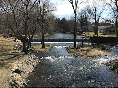
Figure 2. Roller Mill dam on Chiques Creek near Manheim, Pennsylvania (view looking upstream). The height of the dam is around 2.4 m and was originally constructed in the 1700s and rebuilt several times thereafter. Note the sharp difference in stream water levels above and below the dam.
Download figure:
Standard image High-resolution imageIn this perspective letter, we argue that similar to their strong influence on stream and fluvial geomorphology, milldams and their legacies have a significant impact on riparian zone hydrology, biogeochemistry, and water quality functions. We propose that legacy effects of milldams on riparian zones persist for decades and affect their functioning with important consequences for contemporary and future water quality and watershed management practices. We are particularly interested in determining how existing milldams and their removals could affect N processing and fate in riparian soils. We recognize that these effects could also extend to other nutrients such as phosphorus and legacy pollutants such as heavy metals. We provide this assessment for humid, temperate landscapes which are the primary climate settings for the milldams in the eastern US and Europe. Key questions that we explore are: How does the presence or removal of milldams and their legacies affect N cycle processes in riparian zones? What are the key factors or conditions influencing these processes and functions? How could the presence or removal of the dam affect net N release or consumption in riparian zones and what are the consequences for water pollution and watershed management?
We recognize that riparian hydrologic and biogeochemical data specific to milldams and their removals is extremely limited or non-existent. To our knowledge, there are no studies that have explicitly compared the before-and-after and/or upstream-downstream effects of milldams on riparian zones. Since most milldams were originally constructed hundreds of years back, the 'before' condition for stream and riparian ecosystems is difficult to assess and is unknown. Thus, we explore the effects of milldams on riparian N processing through multiple competing hypotheses and observations from complementary studies (e.g. beaver dams and/or studies on downstream effects of hydropower dam releases). We hypothesize that some riparian zone processes could increase N removal or consumption (sink) while others could foster N release (source). We describe how milldams alter riparian zone conditions and discuss how the presence or removal or milldams could affect riparian hydrology and N retention. Our intent here is to raise awareness of milldam legacies and their effects on riparian ecosystems and to stimulate future investigations and studies into milldams and their removals. A better understanding of milldam effects on riparian zones processes and functions will allow for improved decision making with regard to dam removals and management and mitigation choices associated with riparian buffers.
2. Milldam alteration of riparian topography and soils
Milldams alter riparian zone topography, soils and vegetation as a result of altered streamflow and associated hydrologic conditions and subsequent erosion and deposition of sediments. Deposition of sediments upstream of the dams can result in burial of pre-dam floodplains and/or riparian landscapes with creation of new riparian terraces (Merritts et al 2011, 2013, Walter and Merritts 2008; e.g. figures 1 and 2). These changes could extend in all three dimensions—longitudinally along the stream, upstream or downstream of the dam; laterally or orthogonally to the stream; and vertically with depth in the riparian soil profile (as illustrated in figure 3). Milldam effects on riparian zones also vary with the fourth time dimension—age of dam or time since construction. The magnitude of these changes varies with the width and height of the dam, pre-dam valley profile, and the amounts of erosion and sedimentation (Walter and Merritts 2008, Merritts et al 2011). In most cases, the height of the upstream riparian terrace is determined by the height of the milldam (Merritts et al 2011, 2013) with tall milldams resulting in thick legacy sediment or riparian terraces (figure 3(a)). These terraces are thickest at the dam with progressive decrease upstream of the dam (Walter and Merritts 2008). In contrast, riparian soil thickness downstream of the dam could be much less, especially if downstream reaches have not been subjected to sediment deposition and accumulation. Thus, riparian systems that have been affected by milldams likely have much thicker upstream soil profiles than systems that have not experienced this anthropogenic modification. Milldams that span the whole valley-bottom (e.g. supplementary figure S1) likely produce wider (orthogonal to the stream) riparian terraces compared to dams that only span the stream channel. Furthermore, milldams have typically been constructed on second to fourth order streams—streams that provide sufficient flow and gradient and are manageable for construction (Walter and Merritts 2008, Merritts et al 2011). Thus, at the watershed or stream network scale, second to fourth order stream reaches likely reflect the greatest alterations in riparian topography and soils due to milldams.
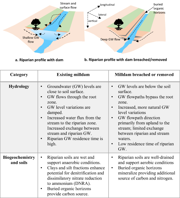
Figure 3. Conceptual model highlighting hydrologic and biogeochemical conditions (upstream of dam) for (a) existing milldams and locations where dams have been and (b) removed or breached.
Download figure:
Standard image High-resolution imageIn contrast to existing milldams, riparian conditions can be very different for locations where dams have been breached or removed (figure 3(b)). Following dam removal, streams erode through the legacy sediments resulting in incised stream banks and stream water levels well below the former dam surface (Merritts et al 2011, 2013, Wegmann et al 2012; figures 3(b) and 4). The drop in stream water levels is particularly significant where the dams were tall. This results in riparian terraces being 'perched' above the new lower stream level (e.g. figure 4). Riparian soils in such situations are well-drained with much of the soil profile above stream baseflow level. The riparian root zone is also above the stream water level, particularly in locations where dams have been recently removed (figure 4).

Figure 4. Cross-section of Chiques creek upstream of Krady milldam (∼1.5 m tall) following dam removal. The Krady milldam located in Rapho Township in Pennsylvania was removed on 9 July 2018. The former water line (during the dam) and the drained soil profile is clearly visible. The root zone was primarily limited to above the former water line. Photo credit: Evan Lewis.
Download figure:
Standard image High-resolution imageThe 'soil profile' in riparian terraces created by milldams is typically composed of light-colored, mineral legacy sediments overlying a dark, organic-rich, soil layer (Walter and Merritts 2008, Merritts et al 2011, 2013, Wegmann et al 2012, Johnson et al 2019, supplementary figures S2 and S3). The dark organic layer likely represents a pre-dam riparian landscape which could have been a marsh, bog, or a swamp (e.g. see Merritts et al 2011, Elliott et al 2013). Multiple other organic layers of varying ages (representing deposition of organic debris upstream of the dam) could also be present at various intermediate depths. Mineral sediments are typically fine-grained silts or clays, but may also contain layers of sandy material (Merritts et al 2011, Wegmann et al 2012, Lutgen et al 2020).
The lower precolonial organic soils can be hundreds to thousands of years old (Walter and Merritts 2008, Johnson et al 2019, Lutgen et al 2020) and range in carbon content from <1% to >7% (Blazejewski et al 2009, Pearson et al 2016, Lutgen et al 2020, Wade et al 2020). N and phosphorus (P) contents of riparian legacy sediments vary considerably but are typically lower than for agricultural and urban upland soils (Lutgen et al 2020). While only a few studies exist, microbial communities associated with the legacy sediments and precolonial soils have been reported to vary considerably with location and depth (Weitzman et al 2014, Sienkiewicz et al 2020). A few studies suggest that buried riparian organic horizons could enhance denitrification and N mineralization (Gurwick et al 2008a, 2008b, Hill 2011, Appling et al 2014). Others however, have reported very low or non-existent microbial activity in buried organic soils (e.g. Orr 2007, Peralta et al 2010, Weitzman et al 2014) with significant recovery taking 1–2 years or more (Song et al 2010, Dandie et al 2011). Thus, the thickness, texture, nutrient (e.g. N or P) and organic C content, and microbial communities of these soils could have important consequences for riparian hydrologic and biogeochemical processes (Weitzman et al 2014, Weitzman and Kaye 2017, Inamdar et al 2020).
While our focus here is primarily on riparian soils and associated N cycle processes, we also recognize that legacy effects of dams could alter the species type, density, and succession of vegetation on riparian terraces both, upstream and downstream of the dam. These vegetative communities could be influenced by dam alteration or regulation of streamflow, flooding, and associated erosion and slumping of streambanks (e.g. Nilsson et al 1997, Nilsson and Berggren 2000, Lisius et al 2018). Anthropogenic activities or disturbance such as construction of raceways, milldam repairs, and milling activities in the vicinity of the dam likely also influenced the presence and growth of riparian vegetation. The type, density, and growth stage of riparian vegetation has been shown to influence riparian N cycling through processes such as plant uptake, litter input and decomposition, and plant–microbe interactions (Dosskey et al 2010).
3. Existing milldams and their effects on riparian hydrology and N processing
Dams backup streamflow, decrease flow velocity, raise stream water levels upstream of the dam, and increase groundwater recharge (Poff et al 2007, Hill and Duval 2009, Csiki and Rhoads 2010, Merritts et al 2011, Poff and Schmidt 2016, Ecke et al 2017, Timpe and Kaplan 2017). The ponding of water behind milldams likely converts a flowing or lotic stream regime to a more of a 'lentic river' system, although the spatial extent of such conversion is strongly dependent on local channel geometry, gradient, and dam height (Fencl et al 2015). More attention has been paid to dam effects on aquatic processing (e.g. streams and their reservoirs; Stanley and Doyle 2002, Riggsbee et al 2007, Burchsted et al 2010, Csiki and Rhoads 2010, Lazar et al 2015, Gold et al 2016, Van Cappellen and Maavara 2016, Almeida et al 2019, Maavara et al 2020). Dams can alter the biogeochemical environment for stream water with consequences for pH, dissolved oxygen, sediment, and nutrients. These studies indicate that hydraulic residence time is a key variable that influences how dams and their reservoirs affect aquatic processing of N (e.g. Maavara et al 2020). Where hydraulic residence time is high, dams and their upstream reservoirs could be important sinks for nutrients like N (Ecke et al 2017, Maavara et al 2020).
In contrast, very few studies have investigated how dams affect hydrologic and biogeochemical conditions in riparian zones. The studies that do exist, have typically focused on the effects of beaver dams on riparian conditions (Lautz et al 2006, Westbrook et al 2006, Hill and Duval 2009, Wang et al 2018) or the effects of regulated outflows from hydropower dams on downstream stream-riparian hydrologic exchange (e.g. Sawyer et al 2009, Gu et al 2012, Shuai et al 2017, Graham et al 2019, Shi et al 2020). Because of their transient nature, beaver dam studies, unlike the long-life milldams, have been able to assess the before-and-after effects of these dams on riparian hydrology and biogeochemistry (e.g. Hill and Duval 2009). These studies report that the backup and increased elevation of stream water at the beaver dam influences both the direction and rate of upland and riparian groundwater inputs to the stream and vice-versa (Westbrook et al 2006, Hill and Duval 2009, Wang et al 2018). Increased surface water levels at the beaver dam decrease the lateral hydraulic gradient of upland groundwaters towards the stream, and in some cases, force streamflow into the riparian zone. This streamflow (now riparian groundwater) entering the riparian zone has been observed to 'loop' around the dam as it flows downstream (Hill and Duval 2009, Lautz et al 2006, e.g. figure 2 in Wang et al 2018). This unique groundwater flow pattern caused by the dam contrasts strongly with the more typical upland-to-stream hydraulic gradient observed in the absence of the dams (Lowrance et al 1997).
Altered hydrologic conditions with beaver dams have been shown to decrease dissolved oxygen concentrations in groundwater and increase anaerobic conditions in riparian soils compared to the pre-dam conditions (Hill and Duval 2009). Anaerobic soil conditions have been reported to decrease groundwater nitrate-N concentrations but result in a 2–3-fold increase in ammonium-N concentrations (Hill and Duval 2009). Hill and Duval (2009) attributed the nitrate-N decrease to denitrification but did not provide an explanation for the ammonium-N increase. Similarly, Lazar et al (2015) attributed increased denitrification from raised water levels and reducing soil conditions as the drivers for nitrate-N decrease in beaver ponds and estimated that this increased denitrification could remove 5%–45% of the watershed nitrate-N loading.
We hypothesize that similar groundwater and biogeochemical conditions as observed for beaver dams exist for milldams, with perhaps greater intensity than those observed for beaver dams due to the larger size, lower water flow-through potential, and longer life of milldams (e.g. Ecke et al 2017). The potential effects of these hydrologic and biogeochemical conditions on riparian N processing are illustrated through multiple competing hypotheses in figure 5. The 'primary' hypothesis reflects the simplest and most obvious process response while the 'alternate' hypothesis indicates a more complex, but viable response.

Figure 5. Conceptual model highlighting the primary and alternate hypotheses for N processing upstream of milldams under existing dam (A) and (B) and dam removed or breached (C) and (D) conditions. The hypotheses describe the N source or sink behavior.
Download figure:
Standard image High-resolution imageGroundwater levels are close to the riparian soil surface upstream of the milldam with lower levels downstream of the dam (figures 3(a) and 5(a)). Following the observations of Hill and Duval (2009), Wang et al (2018), and Westbrook et al (2006), the backup of stream water upstream of the milldam likely forces stream water into the riparian zone with a decrease in the lateral upland to stream hydraulic gradient and a simultaneous increase in groundwater residence time (figure 3(a)). We hypothesize that these wet soil and groundwater conditions upstream of the dam (primary hypothesis in figure 5(a)) encourage reducing or anaerobic soil conditions that favor denitrification (e.g. Lowrance et al 1992, Groffman et al 1992). The fine texture (high silt and clay contents) of legacy sediments in riparian terraces along with elevated organic matter contents in the buried organic horizons could also enhance denitrification (Gurwick et al 2008a, 2008b, Hill 2011, Appling et al 2014, Palta et al 2016). Near-surface groundwater levels and flow paths could also allow for groundwater N to flow through the rooting zone of the riparian forest and enhance plant N uptake (Peterjohn and Correll 1984, Pinay and Decamps 1988, 2019, Lowrance et al 1997; figure 5(a)). These conditions and mechanisms suggest that riparian zones upstream of milldams could be 'hot-spots' (McClain et al 2003, Vidon et al 2010) of N removal via denitrification and plant N uptake with potential benefits for water quality (primary hypothesis, figure 5(a)).
How far upstream from the dam the riparian N hotspot phenomenon extends is unknown. Similarly, little is known about how and to what extent the groundwater flowpaths looping around the dam extend downstream and how they alter the N processing in riparian zones downstream of the dam. Furthermore, because of the obstruction of streamflow, milldams likely reduce the extent and frequency of riparian flooding downstream of the dam. This could reduce the surface saturation of downstream riparian floodplains and thus reduce the potential for N removal via processes like denitrification. While we speculate that upstream effects of the dam on riparian N processing are more pronounced, it is important to determine the extent to which upstream gains in N consumption are rescinded by the reduction in those riparian services downstream of the dam. Understanding these longitudinal patterns in N removal and processing is key for assessing how milldams affect the N budgets at the reach and watershed scales.
While milldams result in near-surface water levels upstream of the dam and increase the depth and volume of riparian soil that is saturated and anaerobic, their presence could dampen the variability in stream water levels (Poff et al 2007). Thus, an otherwise dynamic stream flow regime (in the absence of the dam) is transformed into a more stagnant state. Such a static regime could persist for the life of the dam which could extend for multiple decades or centuries. Previous studies have shown that denitrification rates are generally higher for soils that are subject to greater fluctuations or variations in groundwater levels or soil moisture as opposed to soils with static continuously-wet or continuously-dry moisture regimes (Peralta et al 2013, Guo et al 2014, Bernard-Jannin et al 2017, Ye et al 2017, Tomasek et al 2019, Shi et al 2020). Variations in soil moisture could stimulate both the supply of N (via nitrification during oxygenated soil periods) and organic carbon (via mineralization), as well as the type of microbial community (Peralta et al 2013, 2014). Thus, a continuously-wet and stagnant moisture regime in riparian soils upstream of milldams could result in depressed rates of denitrification (alternate hypothesis in figure 5(b)) resulting in reduced potential for N removal.
Elevated concentrations of ammonium-N in wet, anaerobic, or reduced riparian and wetland soils have been previously attributed to suppression of ammonium consumption by nitrification under reducing or anoxic soil conditions (Hefting et al 2004, Hill and Duval 2009). However, more recent studies suggest that ammonium accumulation under reduced soil conditions could also be driven by dissimilatory nitrate reduction to ammonium (DNRA, e.g. Burgin and Hamilton 2007, Rutting et al 2011, Sgouridis et al 2011, McPhillips et al 2015, Pandey et al 2020). DNRA converts nitrate-N to ammonium-N and competes with denitrification under anoxic soil conditions (Pandey et al 2020). DNRA is also favored over denitrification under elevated dissolved organic carbon (DOC) and low nitrate-N concentrations (DOC to nitrate-N ratios > 12) (Rütting et al 2011, Sgouridis et al 2011, Pandey et al 2020, Wang et al 2020). Similar to their effect for denitrification, fine soil particles such as clays have been reported to enhance DNRA through their influence on water filled pore space and redox potentials (Sgouridis et al 2011, Chen et al 2015). Given the preferential accumulation of fine sediments and organic material in riparian legacy sediments upstream of milldams, these locations could be especially suitable for DNRA (alternate hypothesis in figure 5(b)). Other N transformations such as denitrification linked to oxidation of iron and sulfur species (Petersen et al 2020) and anaerobic ammonium oxidation (Annamox, Gao et al 2018) that have been reported for wetlands also need to be assessed for riparian soils associated with milldams.
We need to determine the net effects of the N cycle processes described above on the total N budget of the riparian zone. If denitrification is the dominant process (primary hypothesis, figure 5(a)), riparian zones would remove N via the conversion of nitrate-N to N2, however, if ammonification or DNRA is significant (alternate hypothesis, figure 5(b)), N could be retained in the ecosystem through the production of ammonium-N. The ultimate fate of accumulated ammonium-N, whether it is released to stream waters following nitrification, or sorbed on riparian soils, or transformed via other N processes such as annamox, is critical and needs to be addressed. If ammonification and DNRA are releasing ammonium-N to stream water and contributing to downstream eutrophication, it could be an ecosystem disservice. In such conditions the presence of milldams and their legacies may not be beneficial for water quality.
4. Breached or removed milldams and their effects on riparian hydrology and N processing
Stream and riparian groundwater levels drop considerably following dam removal or breach with the magnitude of the drop dictated by the height of the dam (figure 3(b)). This results in dewatering or drainage of the riparian soil profile upstream of the dam (figure 4). Well-drained and aerobic soils typically favor nitrification over denitrification which enhances the leaching of nitrate-N from soils as opposed to its removal via denitrification (Cirmo and McDonnell 1997, Hefting et al 2004, Burt and Pinay 2005, Weitzman and Kaye 2017). Weitzman and Kaye (2017) reported elevated rates of nitrification in surficial riparian legacy sediments and suggested these soils could serve as potential nitrate-N sources. This could especially be true if the organic-rich soil layers buried within and below legacy sediments are exposed to drying and mineralization (e.g. Gurwick et al 2008a, 2008b, Hill 2011). Low stream water levels could also result in groundwaters flowing below the root zone (figures 3(b) and 5(c)) and reducing the uptake of N by riparian vegetation (Peterjohn and Correll 1984, Pinay and Decamps 1988, Lowrance et al 1997). Considering these conditions, we hypothesized that riparian terraces with removed or breached dams, and particularly sites with incised streams and recent dam removals (e.g. figure 4 and supplementary figure S4), could potentially serve as sources of N to receiving stream waters (primary hypothesis in figure 5(c)).
Alternately, it is also possible that, despite the increased nitrification and decreased plant N uptake in the drained riparian soils, denitrification rates in groundwater could still be elevated enough to remove any excess N that may be generated by the drained soil profile (alternate hypothesis figure 5(d)). The new 'dynamic' or more variable groundwater regime could stimulate both nitrification and denitrification rates in riparian soils. For example, stream-stage fluctuations and associated hydrologic exchange flows between stream and the riparian zone have been shown to enhance denitrification and the consumption of nitrate-N (Gu et al 2012, Graham et al 2019). Drying-wetting soil moisture cycles associated with the hydrologic variations or pulsing have also been shown to prime and increase denitrification through fresh inputs of C and N associated with mineralization and nitrification (Ye et al 2017, Shi et al 2020). Interestingly, Shi et al (2020) reported elevated denitrification rates at the land-water margin for a hydropower dam reservoir on the upper Mekong river which was subject to rapid water level fluctuations associated with hydropower operations. Similar scenarios could also play out at the landscape scale for riparian systems that have been drained following dam removals and are now subjected to a more dynamic or variable groundwater regime. The loss of anaerobic denitrification soil volume or depth (due to lowering of groundwater levels) could be offset by increasing soil denitrification rates associated with the more dynamic flow and moisture regime. If this happens, it will indicate that riparian ecosystems are resilient to change and can buffer the impacts of dam removals.
5. Riparian discontinuum due to milldams
Building on the two scenarios (existing and breached milldam conditions) presented above, we propose that milldams (and other structures such as beaver dams) create a zone of discontinuity in hydrologic and biogeochemical conditions in riparian zones, particularly upstream of the dam. We call this the 'riparian discontinuum' concept, complementary to the 'river discontinuum' (Ward and Stanford 1983, Burchsted et al 2010) concept proposed for stream and river ecosystems with obstructions or barriers. The river discontinuum concept describes a decoupling in longitudinal connectivity of water and nutrient (N in this case) transport and the concentrations, forms, and processing of N along the stream network. In contrast, the riparian discontinuum concept highlights the orthogonal or lateral (dis)connectivity in water flowpaths and N concentrations, forms, and processing along the upland–riparian–stream interface (conceptual plan view in figure 6).
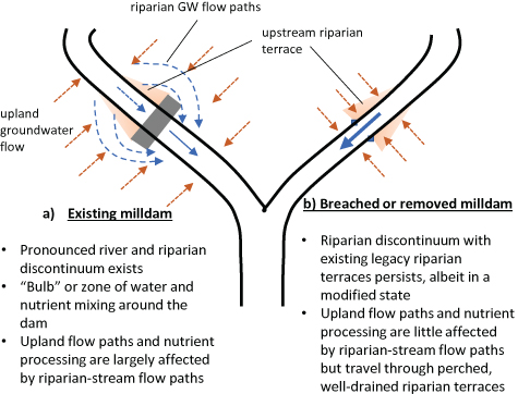
Figure 6. Conceptual model (plan view) characterizing riparian and river discontinuum for (a) existing and (b) breached or removed milldams in the drainage network. GW—groundwater.
Download figure:
Standard image High-resolution image
Where milldams are present, both river and riparian discontinuum persists with the riparian discontinuum expressed through a zone or 'bulb' of water and N flow paths and mixing (figure 6(a)). The hydrologic coupling and water and N exchange between the stream and riparian zone is likely at its strongest and most complex (multiple flowpaths and processes) immediately upstream of the dam and declines with distance away from the dam. At the dam, the hydraulic gradients along the stream and lateral groundwater gradients from upland define the mixing regime and areal extent of the 'bulb' (figure 6(a)). Immediately downstream of the dam, the hydrologic regime and mixing is likely dominated by the upland-to-stream groundwater gradient. We should also note that milldam related legacies such as raceways (Merritts et al 2011) could also affect the hydrologic regime and biogeochemical mixing zone in the vicinity of the dam. The spatial extent of this mixing zone has important implications for N processing in the presence of milldams and the ability of riparian zones in buffering upland N inputs.
Where dams have been removed or breached, this same coupling between stream waters and riparian waters is replaced by a different and new hydrologic and biogeochemical regime. While the river discontinuum no longer exists, the riparian discontinuum likely still persists upstream of the dam, albeit in a modified form, by virtue of the now well-drained legacy terraces (figure 6(b)). Much of the upper soil profile and riparian vegetation on these terraces could be hydrologically disconnected from the groundwater flowpaths (dictated by the height of the terrace and the depth of groundwater flow). Thus, the riparian zone which was a potential hotspot for wet and anaerobic biogeochemical processes (e.g. denitrification and DNRA) in the presence of the dam is replaced with a 'coldspot' (e.g. Vidon et al 2010) for anaerobic processes but a potential hotspot for dry and oxic biogeochemical processes (e.g. mineralization and nitrification) in the absence of the dam. These two riparian scenarios likely represent the two extremes or 'end-members' of the riparian discontinuum in human-modified landscapes. The consequences of riparian discontinuum for water yields and nutrient processing and exports remain unclear, but are likely contributing significantly to stream function and processes in anthropogenically-modified watersheds.
6. Implications of existing and removed milldams for water quality and watershed management
How existing or breached milldams affect N processing in riparian zones could have important consequences for stream water quality and watershed management. Riparian zones are an important tool or practice in the watershed management portfolio for agencies across the US and worldwide (Birgand et al 2007, Pinay et al 2019, Cole et al 2020, Riis et al 2020). Riparian zones are being actively promoted as 'buffers' for streams, particularly for nutrients like N. The Chesapeake Bay Program in the US has an annual goal of planting 900 miles of riparian buffers within the watershed with a final goal of 14 400 miles by 2025 (Chesapeake Bay Program 2016). Millions to billions of dollars are being invested in this initiative through federal, state and local funding (Alliance for the Bay 2015). If riparian sites upstream of milldams are indeed hotspots of denitrification and N removal, these sites could be particularly effective in removing and buffering watershed N inputs and should be actively leveraged or targeted through riparian conservation programs. On the other hand, riparian locations that suggest potential for N sources, would be less effective as N buffers and would likely need additional remediation measures.
Removal of milldams is also increasingly being advocated as an important initiative and priority for improving safety, fish habitat, and natural functions of rivers in the US and elsewhere (Bellmore et al 2017, Foley et al 2017). The European Union has set an ambitious goal of restoring at least 25 000 km of free-flowing rivers by 2030 by removing obsolete barriers and restoring floodplains (European Commission 2020). However, very little attention is being paid to how dam removals could affect water quality processes and N functions of riparian zones. This could be of concern since many states and jurisdictions in the Chesapeake Bay are already falling short of meeting the 'pollution diet' or total maximum daily load (TMDL) N reduction goals (Chesapeake Bay Program 2018). For example, the state of Pennsylvania leads the bay states in non-compliance, with N reductions of 34.1 million pounds required by 2025 to meet TMDL goals (Chesapeake Bay Program 2018). We need to assess how dam removals are affecting riparian buffering potential and how they could affect this N shortfall.
Our analysis highlights multiple potential scenarios and processes by which milldams could affect riparian zone N processing. Some processes could increase N removal while others could foster N release. We need to determine how milldam presence or removal could affect the net riparian N balance and how the N sources and sinks vary spatially (longitudinally, laterally, and with depth) and temporally (with dam present and time since dam removal). While nitrification, denitrification, and plant N uptake processes have typically received the most attention in riparian studies, lesser known processes like DNRA could also have important effects on N budgets in these settings. This will likely require innovative and well-designed field experiments along with robust reach- and watershed-scale modeling. We also need to recognize that milldam effects (presence and removal) on N exports could be masked by other inputs and landuse activities in the watershed, especially in agricultural and urban landscapes with elevated N loadings. If milldam removal increases N exports, appropriate remedial or mitigation practices need to be implemented. On the other hand, if dam removals decrease or do not affect N exports, this could be a win–win situation for both water quality and stream habitat. Finally, this study highlights that human landuse activities (e.g. milldams) and their legacies could persist and continue to affect water quality and ecosystem process for many decades and need to be given careful consideration.
Acknowledgments
This work was supported by NSF Hydrologic Sciences Program Awards 1929747 and 1901787. The authors have confirmed that any identifiable participants in this study have given their consent for publication. We thank the editors and two reviewers for their comments that helped strengthen the manuscript.
Data availability statement
No new data were created or analysed in this study.