

Abstract
Sediment transfer, or connectivity, by aeolian processes between channel-proximal and upland deposits in river valleys is important for the maintenance of river corridor biophysical characteristics. In regulated river systems, dams control the magnitude and duration of discharge. Alterations to the flow regime driven by dams that increase the inundation duration of sediment, or which drive the encroachment of vegetation into areas formerly composed of labile sediment and result in channel narrowing, may reduce sediment transfer from near-channel deposits to uplands via aeolian processes. Employing spatial methods developed by Kasprak et al (2018 Prog. Phys. Geogr.), here we use data describing the areal extent of bare (i.e. subaerially exposed and non-vegetated) sediment along 168 km of the Colorado River downstream from Glen Canyon Dam in Grand Canyon, USA, in conjunction with inundation extent modeling to forecast how future flows of this highly regulated river will drive changes in the areal extent of sediment available for aeolian transport. We also compare modern bare sediment area to that which presumably would have existed under pre-dam hydrographs. Over the next two decades, the planned flow regime from Glen Canyon Dam will result in slight decreases in bare sediment area (−1%) on an annual scale. This is in contrast to pre-dam years, when unregulated low flows led to marked increases in bare sediment area as compared to the current discharge regime. Our findings also indicate that ∼75% of bare sediment in the study reach is inundated continuously at present, owing to increased baseflows in the post-dam flow regime; consequently, any reductions in flows below modern-day low discharges have the potential to expose large areas of bare sediment. We use vegetation modeling to quantify areas susceptible to vegetation encroachment under future flows, finding that 80% of bare sediment area is suitable for colonization by invasive tamarisk under the current flow regime. Our findings imply that the Colorado River in Grand Canyon, a system marked by widespread erosion of sediment resources and encroachment of riparian vegetation in the post-dam period, is likely to continue to see decreasing bare sediment extent over the coming decades in the absence of direct intervention through flow regime modification or widespread vegetation removal.
Export citation and abstract BibTeX RIS

Original content from this work may be used under the terms of the Creative Commons Attribution 4.0 license. Any further distribution of this work must maintain attribution to the author(s) and the title of the work, journal citation and DOI.
1. Introduction
In river corridors, the transfer of water, nutrients, and sediment occurs across a diverse assemblage of landforms, both within and outside of the active channel. Recent work in geomorphology has elucidated the importance of sediment transfer between the active channel, channel-margin bars, floodplains, and uplands, as vital for the maintenance of dynamic riverscapes (figure 1; Ward et al 2002, Belnap et al 2011, Wohl and Beckman 2014, Bracken et al 2015, Magilligan et al 2016, Wohl 2017). The processes supported by sediment connectivity are myriad, including the building and maintenance of bars (Mueller et al 2014), source-bordering dunefields (Draut and Rubin 2008), their associated habitats for aquatic and terrestrial organisms, and the recreational use (Kearsley et al 1994) and traditional cultural values (Pederson and O'Brien 2014) associated with these landforms.
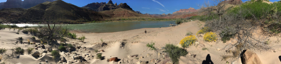
Figure 1. Photograph of a coupled fluvial sandbar and aeolian dune along the Colorado River in Grand Canyon. River flow is from left to right. When river discharge is low, the areal extent of sand exposed for aeolian transfer increases. Conversely, high flows inundate a greater area of the sand, precluding aeolian transfer to uplands. Photo credit J. Sankey.
Download figure:
Standard image High-resolution imageThis continued sediment transfer is contingent upon both an adequate supply of sediment and the presence of transport pathways for its movement (figures 1 and 2; Draut 2012, East et al 2016, 2017). Sediment may transit these pathways by aeolian, fluvial, alluvial, or colluvial processes that can be inhibited by topographic and vegetative barriers (East et al 2016, Sankey et al 2018a, 2018b). Any river disturbances or management activities that alter either sediment availability, or which form barriers to sediment transfer, can impact the background state of material transfer. These disturbances include, among others, shifts in land use (Walling and Fang 2003, Kasprak et al 2013, Soar et al 2017, Wohl 2020) and altered hydro-climatic regimes (Poesen et al 2003, Christensen et al 2004, Palmer et al 2008, Belmont et al 2011). Additional impacts to sediment connectivity can also include river diversion or irrigation works that modify flow regimes (Gaeuman et al 2005, Mossa 2016, Wohl 2016, Jones 2018) and the operation of dams (Schmidt and Wilcock 2008, Grant et al 2013, Magilligan et al 2016), both of which can inundate or expose sediment, affecting transfer between sites in river corridors.
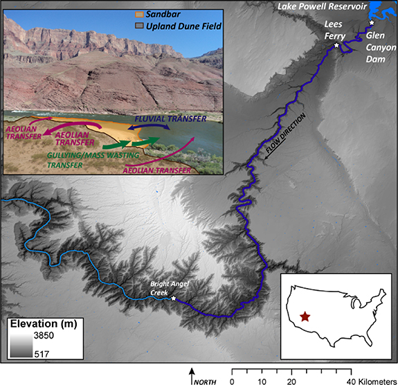
Figure 2. Overview map of the upstream portion of the Colorado River in Grand Canyon, Arizona; 168 km study reach examined here spans between Glen Canyon Dam and Bright Angel Creek. The USGS gage at Lees Ferry, Arizona (#09380000) is used here for flow measurements. Inset image shows mechanisms of sediment transfer between fluvial and upland environments in Grand Canyon; image modified with permission from Kasprak et al (2018). Copyright © 2018, © SAGE Publications.
Download figure:
Standard image High-resolution imageDespite the eco-geomorphic importance of sediment connectivity, and the propensity for human activities to alter connectivity, direct measurement of sediment exchange between the various storage sites in river valleys is a challenging proposition. This is because of the large spatial areas over which connectivity occurs, both longitudinally and transversely within river corridors, along with the array of pathways and storage sites that may see fluxes of sediment over a given monitoring period. In lieu of direct measurement, remote sensing of land cover, including via light detection and ranging, single- and multibeam sonar, and classification of aerial photographs, offers information on the propensity for sediment transfer to occur (Liu and Coulthard 2015).
In this letter, we leverage one of the most extensive and highest-resolution remote sensing datasets available in any river corridor worldwide to quantify shifts in the exposure of sediment as a function of changes in inundation by a river flow regime which has been fundamentally altered by dam operation. Our analysis focuses on the upper 168 km of the Colorado River corridor in Grand Canyon, Arizona, USA. Here we focus on bare (i.e. unvegetated and subaerially exposed) sediment extent due to its importance as a prerequisite for aeolian sediment transfer between the active river channel and uplands. We initially conduct this analysis over the period 2008–2016. We then contextualize our findings from this reference period by modeling bare sediment extent under six contrasting historical flow regimes (two pre-dam and four post-dam). We also forecast how bare sediment extent may shift in the future by modeling nine theoretical alternative future flow regimes that have been considered for dam management. In addition to these analyses of hydrologic effects on bare sediment extent, we use vegetation habitat suitability modeling to estimate future encroachment of riparian plants into areas currently composed of bare sediment throughout the study reach. This study builds on the initial results of Kasprak et al (2018), which quantified the relative importance of hydrologic alteration and vegetation encroachment on reducing bare sediment along the Colorado River, and primarily analyzed land cover data over the historic period 1921–2017. Using the methods developed in Kasprak et al (2018), this letter primarily explores future trajectories over a much longer reach of the Colorado River using newly published spatial data, contextualizes predictions of future bare sediment extent in light of historic Colorado River flows, and employs mechanistic vegetation modeling to estimate future plant colonization of bare sediment. Our results provide important context for conceptualizing potential future connectivity trajectories and for informing management regimes for regulated dryland rivers that promote ongoing sediment connectivity.
2. Study setting
2.1. The Colorado River in Grand Canyon
The Grand Canyon is one of Earth's iconic landscapes, a bedrock gorge formed from incision of the Colorado River and synchronous uplift of the Colorado Plateau (Karlstrom et al 2008, 2012, Pederson, 2012). From the upstream boundary of Grand Canyon National Park at Lees Ferry, Arizona, 25 km downstream from Glen Canyon Dam (figure 2), the Colorado River flows for approximately 475 km through Grand Canyon to the Grand Wash Cliffs and the upstream reaches of Lake Mead. The river is marked by a series of flatwater segments interrupted by rapids formed by coarse-grained debris introduced from episodic flooding of tributary side canyons, and these debris fan-eddy complexes give rise to the pool-drop nature of the Colorado (Schmidt and Rubin 1995, Mueller et al 2014). Despite the imposed nature of the channel planform, in many places the river exhibits characteristics of a sand-bedded alluvial system, replete with bedforms (Wright and Kaplinski 2011, Buscombe et al 2014a) and sandbars that form in eddies (Grams et al 2013, Kaplinski et al 2017).
Terraces and upland surfaces are found throughout the study area. These landforms lie above the elevation of modern floods and are often marked by extensive aeolian dunefields and gully networks (Sankey and Draut 2014). Sediment is transferred to uplands by aeolian processes from river-proximal sandbars and channel margins (Langford 1989, East et al 2016, 2017). The largest sediment fluxes and the most widespread volumes of sediment aggradation at these upland locations have been observed via repeat topographic surveys to be associated with high volumes of upwind sediment deposition at fluvial sandbars (Sankey et al 2018a, 2018b). Because sandbars and upland aeolian landscapes in Grand Canyon are primarily composed of sand-sized sediment (0.625–2 mm; East et al 2016, Hamill et al 2018), throughout the remainder of this study we focus on, and map, sand in the study reach.
The continued sediment resupply of aeolian landscapes, contingent upon the availability of transportable sand in upwind areas, is important for the maintenance of ecologically sensitive landscapes in Grand Canyon and dryland rivers worldwide. Sand deposition in uplands is also desirable because of the myriad archaeological sites that line the river corridor, relics of human habitation within Grand Canyon primarily during the Puebloan and Protohistoric periods (800–1776 C.E.; Fairley 2005, Pederson and O'Brien 2014). In situ burial of these sites by aeolian sediment provides protection against erosion and removal of artifacts by runoff and mass wasting processes that would otherwise occur (Collins et al 2012, Cook et al 2019).
2.2. Alterations to flow, sediment supply, and vegetation
The state of the Colorado River and its valley have been fundamentally altered by the construction and operation of Glen Canyon Dam upstream, beginning in 1963. Chief among these alterations is a drastic reduction in sediment supply to Grand Canyon resulting from sediment trapping within Lake Powell Reservoir upstream of Glen Canyon Dam. The annual amount of fine sediment currently moving past the USGS gauge at Lees Ferry, Arizona (# 09380000) is <5% of its pre-dam volume (Topping et al 2000, Hazel et al 2006). This reduction in sediment supply has manifested as widespread erosion of downstream sandbars (Kearsley et al 1994, Kaplinski et al 2008). Second, the hydrology of the Colorado River has undergone a shift in the post-dam period. In the pre-dam period, the system was characterized by large spring/summer floods emanating from snowmelt runoff in the upper Green and Colorado River watersheds, along with very low flows for the remainder of the year (figure 3; Dean and Topping 2019). At present, flows through Grand Canyon are relatively stable, with the elimination of large floods and low flows. Operation of Glen Canyon Dam in support of load-following hydroelectric power generation (i.e. hydropeaking; Jones 2014) also results in daily flow fluctuations. For reference, the median daily discharge of the Colorado River at Lees Ferry was 225 m3 s−1 in the pre-dam period and has been 348 m3 s−1 in the post-dam era (U.S. Geological Survey 2020). The highest-magnitude flows that occur at present are those related to high flow experiments (HFEs), which are short-duration (<10 d) increased flows, up to 1270 m3 s−1, intended to redistribute sand from the channel bed into channel-margin sandbars. Finally, the reduction in large floods and the stabilized discharge regime have led to widespread encroachment of vegetation onto areas previously composed of bare sand (Sankey et al 2015). Abundant stands of numerous plant species, particularly the riparian shrubs tamarisk (Tamarix sp.), arrowweed (Pluchea sericea), and baccharis (Baccharis spp.; Sankey et al 2015, Butterfield et al 2018, Palmquist et al 2018, Scott et al 2018), can now be found throughout the river corridor.
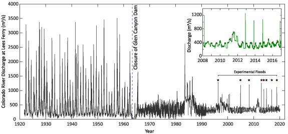
Figure 3. Discharge record of the Colorado River at Lees Ferry, Arizona (USGS gage # 09380000) between 1922 and 2020. Inset shows discharge over the 2008–2016 reference period. Stars denote the timing of eight experimental floods released from Glen Canyon Dam in the post-dam period with the goal of redistributing sediment along the Colorado River and maintaining sandbars within the river corridor. Main hydrograph image modified from Kasprak et al (2018). Copyright © 2018, © SAGE Publications.
Download figure:
Standard image High-resolution image2.3. Impacts on sediment connectivity and current management approaches
The impacts of Glen Canyon Dam on Colorado River sediment supply, hydrology, and riparian vegetation cover have been profound, and have the potential to dramatically decrease sediment availability and exchange in Grand Canyon. At the same time, current management activities aimed at improving recreational river runners' experiences in Grand Canyon, along with maintaining and restoring ecological processes, have the potential to also increase sediment connectivity. These include (a) HFEs intended to rebuild and maintain exposed sandbar surfaces used as campsites (Mueller et al 2014), (b) vegetation removal projects that may re-open sediment transport pathways (US Bureau of Reclamation 2016), and (c) experimental flow regimes from Glen Canyon Dam that may result in more extended exposure periods for river-proximal sediment (US Bureau of Reclamation 2016).
3. Methods
3.1. Sand mapping and discharge modeling
We combined multiple remote-sensing and in situ datasets collected between 2009 and 2015 to produce a map, represented as a GIS polygon shapefile, of sand between Glen Canyon Dam and Bright Angel Creek along 168 km of the Colorado River. A full description of the collection methods and dataset analysis techniques is available in Kasprak et al (2018), and we refer readers to that manuscript, particularly figure 6, for an overview of the spatial methods used here. Sand was mapped between the bed of the Colorado River up to the stage of the largest estimated pre-dam flood discharge of 5947 m3 s−1. These datasets include:
- Singlebeam and multibeam sonar (Kaplinski et al 2017, Kaplinski et al 2020a, Kaplinski et al 2020b, Kaplinski et al 2020c, Kaplinski et al 2020d), collected in subsets between 2009 and 2015, as complete mapping of the full 168 km study reach in a single campaign was logistically infeasible. These datasets cover areas from discharges of 0 m3 s−1 (i.e. the bottom of the river) to approximately 340 m3 s−1. We used the method of Buscombe et al (2014a, 2014b) to include only those areas of multibeam surveys mapped as sand. Singlebeam sonar was used to map shallow areas and eddy recirculation zones which are predominantly composed of sand, and thus we classified all singlebeam-mapped areas as sand.
- Total station surveys of channel-margin sand deposits, approximately between stages of 340 m3 s−1 and 1270 m3 s−1, collected concurrently with the sonar surveys above.
- Areas of sand derived from automated classification of 0.2 m resolution aerial photographs collected in 2013 (Sankey et al 2018c), covering those areas between discharges of 1270 m3 s−1 and the pre-dam estimated flood of record, 5947 m3 s−1.
The resulting map of sand extent was representative of areal sediment cover as it existed between 2009 and 2015. For any given discharge from Glen Canyon Dam, we estimated the amount of bare sand (i.e. sand which is both subaerially exposed and unvegetated; note that we use bare sand and exposed sand interchangeably hereafter) by clipping the map of total sand with inundation polygons developed by Magirl et al (2008) using one-dimensional step-backwater hydraulic modeling for 14 discrete discharges between 226 m3 s−1 and 5947 m3 s−1 (figure 4) and performing linear interpolation between these discharges to estimate bare sand extent at 28 m3 s−1 (i.e. 1000 ft3 s−1) discharge increments. We similarly performed linear interpolation between exposed sand at the minimum discharge modeled by Magirl et al (2008) and the total map of sand in the study reach to estimate sand exposure down to a discharge of 0 m3 s−1. The relationship between river stage and exposed sand area is highly nonlinear (figure 4), and there are about three times as much bare sand below the stage of the lowest regularly occurring flows (226 m3 s−1) than across the entire remaining range of flows up to the modern controlled flood discharge (1270 m3 s−1). Approximately 75% of bare sand throughout the reach is inundated continuously by modern flows and is thus subject to fluvial transport processes, but not aeolian or alluvial transport. We note that because the bare sand extent map used here is reflective of current (2009–2015) conditions in Grand Canyon, and because Glen Canyon Dam has resulted in a ∼95% reduction in sediment supply to Grand Canyon (section 2.2), the areal extent of bare sand in the pre-dam period is likely to have been much greater than shown in figure 4.

Figure 4. Relationship between Colorado River discharge and the areal extent of exposed sand per kilometer throughout the 168 km study reach. Discharges range between 0 m3 s−1 and the inferred pre-dam flood of record in Grand Canyon, 5947 m3 s−1. High flow experiments refer to experimental floods released from Glen Canyon Dam, all of which have had discharges ≤1270 m3 s−1.
Download figure:
Standard image High-resolution image3.2. Simulation parameters
We modeled the daily extent of bare sand using 16 input daily hydrographs (figure 5). These can be categorized into four groups:
- (a)Reference Flows. The mean daily discharge of the Colorado River at Lees Ferry, Arizona over the 8 year period from October 2008 to October 2016. This period is generally representative of Colorado River flows through Grand Canyon between 1996 and 2016, prior to the re-negotiation of Glen Canyon Dam operations in 2016 which will dictate flow regimes during the next two decades (2017–2037).
- (b)Actual Historical Flows. Mean daily discharge records from two pre-dam water years (i.e. 1 October–30 September): 1927, a high discharge pre-dam year, and 1934, a low-discharge pre-dam year, along with four post-dam water years: (a) 1983, a long-duration snowmelt flood requiring the use of emergency spillway releases, (b) 1990, unrestricted daily flow fluctuations to meet hydropower demand, (c) 2000, a long-duration summer experimental flow involving low steady releases of 226 m3 s−1, and (d) 2018, which included daily hydropower flow variation, a fall HFE, and summer weekend low flows for macroinvertebrate production; 2018 is an example of a typical annual hydrograph that can be expected over the next two decades of Glen Canyon Dam operations.
- (c)Alternative Future Flows. Mean daily discharges for seven alternative operational regimes for Glen Canyon Dam considered as part of the U.S. Bureau of Reclamation's Long Term Experimental and Management Plan environmental impact statement process (hereafter LTEMP EIS; US Bureau of Reclamation 2016), completed in 2016, and which will govern dam releases from 2017 to 2037. These seven alternative future flow regimes comprised a variety of resource management goals, including maximizing sediment retention, hydropower production, and fish conservation, among others. All of these future alternatives provide for the release of 1.02 × 10¹⁰ m3 of water per year, an amount mandated by the 1922 Colorado River Compact and subsequent statutory documents to meet downstream water delivery demands. Among these, Alternative D was selected to guide Glen Canyon Dam operations. The 2018 hydrograph discussed above is an example of a 'typical' year that can be expected through 2037 under Alternative D.
- (d)Theoretical Flows. To evaluate the potential for flows far outside the normal range of Glen Canyon Dam operations to expose additional amounts of bare sand, we modeled two theoretical discharges, including (a) constant discharge over the entire year and (b) extremely low flows (28 m3 s−1 or 1000 ft3 s−1) during the March-May windy season in Grand Canyon (Caster et al 2014).

Figure 5. Annual daily hydrographs for each of the 15 modeled discharge regimes used to estimate exposed sand area. Actual pre-dam hydrographs shown in blue, actual post-dam hydrographs shown in red, LTEMP EIS alternative hydrographs shown in purple, and theoretical hydrographs shown in green. For consistency with other hydrographs, water year flow records were transformed to calendar year dates. Note variable y-axes among the plots. For reference, the mean daily discharge over the 2008–2016 reference period was 358 m3 s−1.
Download figure:
Standard image High-resolution image3.3. Vegetation habitat suitability modeling
To quantify the potential for additional bare sand loss due to future vegetation encroachment, we used vegetation habitat suitability models developed by Butterfield et al (2018), which assess the ability of a particular spatial location to support 75 common species of plants, which we binned into four broad-level vegetation functional groups:
- Xeric Shrubs and Grasses, desert plants commonly found in the Colorado Plateau, Great Basin, and Mojave Desert ecosystems that surround the Grand Canyon.
- Riparian Herbs, non-woody wetland vegetation including annual and perennial grasses found in the modern riparian zone of the Colorado River.
- Native Riparian Shrubs, woody plants found in the riparian zone of the Colorado River (e.g. <1270 m3 s−1 stage) that rely on water from the river.
- Non-Native Riparian Shrubs, which are entirely tamarisk, a non-native woody plant which is now ubiquitous along waterways of the region.
We modeled vegetation suitability at 22 sites distributed throughout the study reach where both vegetation monitoring and topographic surveys have been conducted (vegetation monitoring since 2013; Palmquist et al 2018, topographic surveys since 1990, Kaplinski et al 2014). We determined habitat suitability in a binary sense (i.e. a location is either 'suitable' or 'unsuitable' for a given species group) after application of species-specific thresholds based on (a) the elevation of a location above the channel corresponding to a Colorado River discharge of 453 m3 s−1, a typical daily peak discharge that has been found to influence the composition of riparian vegetation communities, and (b) the number of days per year that location is inundated. These two metrics serve as proxies for depth to water table and flooding tolerance, which have been identified as the dominant controls on vegetation presence and position in Grand Canyon (Butterfield et al 2018). As opposed to the 16 flow regimes that we used to model sand exposure (section 3.2), here we only apply vegetation modeling to the 2008–2016 discharge record. This is because the vegetation suitability model was constructed based on field monitoring data collected during this period and thus cannot be expected to adequately predict the impact of other flow regimes over shorter annual timescales.
4. Results
4.1. Sand exposure under varying discharge regimes
The average daily areal extent of bare sand over the 168 km study reach under each of the modeled hydrographs is shown in figure 6. Figure 7 compares the cumulative annual extent of bare sand for each of the modeled hydrographs to that of the reference period 2008–2016. During the reference period, there was an average of 1.5 km2 of bare sand exposed each day, and cumulatively over each year, an average of 546.7 km2 of bare sand were exposed. Both pre-dam hydrographs that were modeled (section 3.2) resulted in an increase in daily bare sand areal extent as compared to this reference period; 1927, a high-water year, and 1934, a low-water year, resulted in a 42% and 192% increase, respectively.
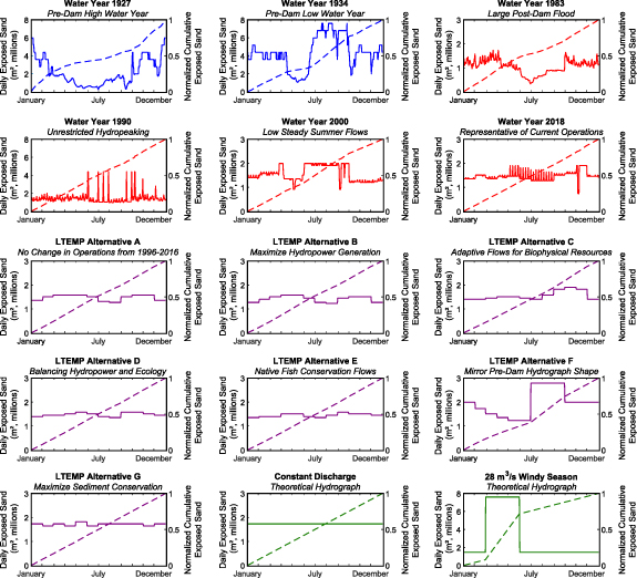
Figure 6. Results of exposed sand analysis for each of the 15 modeled discharge regimes shown in figure 5. In each plot, areal extent of exposed sand per day is shown in solid lines and normalized annual accumulation of sand (i.e. between 0 and 1) is shown in dashed lines. Results from actual pre-dam hydrographs shown in blue, actual post-dam hydrographs shown in red, LTEMP EIS alternative hydrographs shown in purple, and theoretical hydrographs shown in green.
Download figure:
Standard image High-resolution image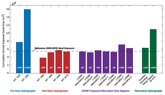
Figure 7. Cumulative annual exposed sand area under each of the 15 hydrographs shown in figure 5. Average areal extent of exposed sand during the 2008–2016 reference period is shown in dashed line. Percent change in areal extent of sand as compared to this reference period is indicated within each bar.
Download figure:
Standard image High-resolution imageIn the reference period 2008–2016, there was generally more bare sand exposed on a daily basis than during each of the modeled post-dam hydrographs (section 3.2). This is true for water year (WY) 1983 (−30% compared to the reference period), which saw the highest flows during the post-dam period of record resulting from rapid snowmelt of an extensive snowpack in the upper Colorado River Basin. Reductions in bare sand area were also seen in WY 1990 (−5%) and 2018 (−2%) though the latter was the most similar to the reference period. In contrast, WY 2000, which was marked by low steady summer flows (226 m3 s−1 from June through August), resulted in a 4% increase in bare sand areal extent as compared to 2008–2016. In contrast to the pre-dam water years (1927 and 1934), the accumulation of bare sand in post-dam years occurs in a much more constant fashion over the course of a water year as a result of the loss of spring floods and summer low flows that were characteristic of the pre-dam flow regime.
Each of the seven examined alternative future flow regimes under the LTEMP EIS process resulted in modest changes in the areal extent of exposed bare sand (figure 7). Alternatives A, B, C, D, and E resulted in at least a 5% decrease in sand exposure (Alternative B) or at most a 4% increase (Alternative C). Alternative F, which sought to mirror pre-dam hydrograph shape, albeit with a peak flood magnitude that would be markedly reduced compared to pre-dam discharges, also provided for low summer and fall flows, and produced a 30% increase in the extent of exposed sand. Alternative G, with low steady flows throughout the year, also resulted in a relatively modest increase in exposed sand extent (14%).
Finally, we examined two theoretical annual hydrographs in order to examine the impact of extreme low flows and constant discharge on exposed sand area (figure 7). A constant year-round discharge of 322 m3 s−1, which results in the release of 1.02 × 10¹⁰ m3 of water per year from Glen Canyon Dam, thus consistent with each of the alternative future flows, resulted in a 16% increase in exposed sand area as compared to the reference period. Reducing discharge during the windy season in Grand Canyon (i.e. March–May; Caster et al 2014) to 28 m3 s−1, much lower than modern low flows of 226 m3 s−1, resulted in a 100% increase in exposed sand area. In summary, flows during the reference period 2008–2016 produced modest increases in exposed sand area as compared to other analyzed post-dam annual hydrographs, and the reference period is largely consistent with predicted exposed sand areas under the LTEMP alternative hydrographs. However, these exposed sand areas are still far smaller than those that would have existed under pre-dam discharges which included very low summer flows.
4.2. Vegetation habitat suitability modeling
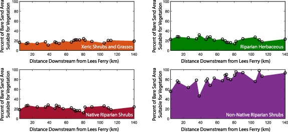
Suitability modeling was completed for 22 sites between 5 km and 140 km downstream of Lees Ferry, encompassing 80% of the study reach. At all of these sites, at least a portion of the current bare sand area is suitable for colonization by one or more of the four broad-level vegetation species groups examined here (figure 8; section 3.3). For xeric shrubs and grasses, the proportion of bare sand area at these sites suitable for colonization averaged 18% (min–max range was 11%–24%). For riparian herbaceous species, the average bare sand area suitable for colonization was 23% (14%–32%), whereas native riparian shrubs averaged 22% (12%–28%). Notably, the potential for colonization by the non-native riparian shrub group, which was entirely composed of tamarisk, was much greater: average bare sand area suitable for colonization was 80%, and this suitability ranged between 46% and 98%.
Figure 8. Results of vegetation habitat suitability modeling at 22 sandbar sites with topographic and vegetation data using the 2008–2016 hydrograph (figure 5) for four broad-level species groups.
Download figure:
Standard image High-resolution image
5. Discussion
Our results reveal the importance of low river flows in exposing large areal extents of sand, along with indicating that the relative homogenization of flows (sensu Poff et al 2007) in the post-dam era has led to reduced sand exposure. We also found that vegetation encroachment is likely to continue under the current management of Glen Canyon Dam. Our initial work on a short 28 km subset of the 168 km study reach examined here (Kasprak et al 2018) revealed large declines in bare sand area during the post-dam period (49% reduction in area compared to pre-dam exposed sand extent) and provided the methodological foundation for this study, which is conducted over a much longer segment of the Colorado River. This study explores the effect of numerous contrasting hydrographs on sand exposure, finding that bare sand is scarcer at present as compared to pre-dam periods, largely due to the loss of extended periods of low flows under ongoing water release patterns from Glen Canyon Dam. Bare sand will continue to decrease in extent under future operations of Glen Canyon Dam, barring the introduction of markedly different theoretical flow regimes that include flows much lower than today's minimum discharge levels, and also due to the continued colonization of bare sand surfaces by plants, particularly tamarisk.
5.1. Pre-dam sand exposure and the importance of low flows
As compared to the 2008–2016 reference period, both pre-dam annual hydrographs resulted in a greater areal extent of exposed sand. While this was largely expected for 1934, a pre-dam drought year where the peak flow only reached 700 m3 s−1, we found that more exposed sand was also present in 1927, a pre-dam high water year where flows peaked at over 3300 m3 s−1. Extreme low flows have largely been lost in Grand Canyon, and more than 75% of the bare sand in the study reach is today located at stages lower than that reached by the contemporary baseflow discharge of 226 m3 s−1 (figure 4). This means that most of the bare sand in the system is currently inundated year-round and thus not available for aeolian remobilization, nor for use by recreational river runners as campsites and terrestrial wildlife for habitat. For instance, despite the fact that floods during 1927 reached 3300 m3 s−1, a value far higher than the daily maximum discharge of 1266 m3 s−1 during the 2008–2016 reference period, this pre-dam high water year still resulted in a 42% increase in exposed sand area as compared to the reference period, precisely because the former period still saw low flows able to expose sand within the active river channel, following the spring/summer high flows and extending through the following spring's windy season. The current flow regime is marked by the loss of sand-inundating spring floods that would have mobilized and deposited sand at comparatively high stage elevations, yet baseflows have also been increased to accommodate year-round hydropower generation and to ensure the delivery of water to downstream agricultural and domestic users (US Bureau of Reclamation 2016). To this end, the median daily discharge of the Colorado River at Lees Ferry was 225 m3 s−1 in the pre-dam period, and has increased to 348 m3 s−1 in the post-dam period, demonstrating an increase in baseflow at the expense of variability in spring snowmelt floods and summer/fall low flows. The highly nonlinear nature of the discharge-exposed sand curve in figure 4 emphasizes that any reduction in low flows below the current 226 m3 s−1 minimum releases from Glen Canyon Dam has the potential to expose large volumes of sand for each corresponding decrease in flow volume.
5.2. Ongoing homogenization of the flow regime
The reductions in flow variability during the 2008–2016 reference period that resulted in decreased sand exposure as compared to even a pre-dam high water year (i.e. 1927) were reflective of future flows in the system as conceptualized in the LTEMP EIS (section 3.2). With the exception of Alternative F, which allows for spring high flows and summer/fall low flows to mimic the form of the pre-dam hydrograph, the remaining alternative future flows were quite static in terms of flow variability. The average difference between annual high and low discharges across Alternatives A, B, C, D, E, and G was 143 m3 s−1. For Alternative F, this difference was 362 m3 s−1. The average difference between annual peak and low discharge in the pre-dam period was 2116 m3 s−1 across 40 years of record. Furthermore, none of the alternative flow regimes allowed for discharges less than 226 m3 s−1, yet flows below this level, common in the pre-dam period when average annual low flow was 81 m3 s−1, have the potential to expose exponentially larger areal extents of sand along the study reach (figure 4).
Each of the alternative future flows were designed in the LTEMP EIS to balance multiple, often competing, goals related to valued resources in Grand Canyon. Among these were native fish conservation, in-channel sediment retention, and hydropower generation. Nevertheless, with the exception of Alternative F, none of the examined alternatives, including the preferred and ultimately selected Alternative D, would have resulted in appreciably greater areal extents of exposed sand. Alternative D, the selected alternative, was predicted to result in a 1% decrease in exposed sand area. The 2018 hydrograph (figure 5), which was generally representative of operations under Alternative D over the next 20 years, resulted in a 2% decrease in exposed sand area as compared to the reference period. Thus, we conclude that over the next two decades, future flows will not result in appreciably greater areal extents of exposed sand, and will almost certainly not approach the extent of bare sand driven by pre-dam hydrographs, barring unforeseen flow variability such as reductions in flow necessitated by basin-wide drought and/or climate change (see Udall and Overpeck 2017). Of the two examined theoretical discharge regimes (figure 5), low flows during the windy season do have the potential to double the areal extent of exposed sand (figure 7) as compared to both Alternative D and the 2008–2016 reference period. However, in the context of current minimum flows from Glen Canyon Dam, this theoretical flow regime contains low flows that are roughly 10% the magnitude of current minimum flows, illustrating the degree of system shock necessary to appreciably change the amount of exposed sand.
5.3. Anticipated future vegetation encroachment
The results of vegetation habitat suitability modeling (section 3.3; figure 8) revealed that bare sand in each of the 22 modeled sites is susceptible to vegetation encroachment by all of the four modeled species groups. Under the 2008–2016 hydrograph, which is representative of ongoing and future releases from Glen Canyon Dam, an average of 80%, and up to 98% of bare sand area is suitable habitat for tamarisk. Since the closure of Glen Canyon Dam in 1963, the loss of large scouring floods and low flows which historically dewatered emergent plants in the riparian zone (Mueller et al 2018) have resulted in widespread vegetation encroachment. Sedimentation caused by vegetation that has encroached onto formerly active portions of sandbars has also resulted in aggradation of those surfaces above the elevation inundated by high flows, further reducing areas of sand available for aeolian transport (Butterfield et al 2020). Our results imply that colonization of bare sand by riparian vegetation is likely to continue over the next two decades, resulting in further losses of bare sand throughout the study reach. This is due to the combination of a future flow regime that is likely to be homogenous in discharge variability compared to the pre-dam period (section 5.2), along with the results of our suitability modeling during 2008–2016, which indicated that the flow regime was supportive of continued vegetation encroachment. We note that our estimates of the impact of vegetation encroachment on bare sand extent likely represent a conservative approximation of its overall effect on aeolian sand transport, as plants not only colonize areas formerly composed of bare sand, but also drive preferential deposition of sand transported through vegetated areas (Sankey et al 2013, Gonzales et al 2018).
5.4. Inherent assumptions and uncertainty
Although the results of this study are drawn from high-resolution remote sensing land cover and topographic mapping in conjunction with inundation modeling that have been employed in numerous studies in Grand Canyon (Hazel et al 2006, Grams et al 2013, Mueller et al 2014, Sankey et al 2015, Kaplinski et al 2017, Kasprak et al 2018, Grams et al 2019), there are simplifications that may have implications for our findings. First, we used a map of sand extent that was constructed during multiple surveys made between 2009 and 2015. We surmise that the pre-dam bare sand extent would have been much larger, and with a different distribution between channel bottom and uplands, owing to the progressive erosion of sandbars, incision of the channel bed, and scour of channel margin and upland sand deposits which have occurred since dam closure in 1963. Additionally, we used static inundation extents which do not account for the role of channel morphodynamics in changing the areas submerged by a given discharge. However, these inundation extents were found to be accurate to within ∼1 m during model validation (Magirl et al 2008). Given the imposed channel characteristics within much of Grand Canyon, we do not believe that inundation extents shift drastically through time.
We believe that uncertainty in our exposed sand area maps is minimal. With regard to sand that was mapped from multibeam sonar bathymetry, Buscombe et al (2014b) found the classification method employed accurately discriminated 95% of sand-sized substrates using field-collected validation points. The upland sand map derived from classification of 0.2 m resolution imagery had an estimated sand classification accuracy of 97% as compared with field surveys (Sankey et al 2018c). As mentioned above, we also anticipate that uncertainty in our sand extent mapping is minimal compared to uncertainties in estimating pre-dam sand exposure throughout the reach that would have occurred in light of much larger sediment loads prior to river regulation, which we did not attempt to quantify here. With regard to vegetation suitability modeling, we similarly believe that uncertainty around these estimates is low, as the models themselves were developed using plant monitoring data along the Colorado River in Grand Canyon. Additionally, upon validation, model fit for species niche models was good to excellent based on AUC and confusion matrices for all of the plant species used (Butterfield et al 2018).
5.5. Implications for river corridor management
We did not attempt to constrain the areal extent of sand that is 'acceptable' or 'ideal' for the maintenance of biophysical processes in Grand Canyon, but rather simply contrasted the exposed sand extents made available under divergent flow regimes relative to historical and current levels. Likewise, it is unknown whether aeolian remobilization of sediment in Grand Canyon is a linear or threshold process, and thus whether a given areal extent of sand will result in incrementally or vastly different volumes of sediment sourced from near channel areas and transported to uplands. There is, however, evidence that current sand extent is insufficient to prevent long-term scour and gully erosion of upland deposits (Draut 2012) in the absence of annual resupply by experimental floods from Glen Canyon Dam (Sankey et al 2018b), and also that ongoing vegetation encroachment, which presents a physical barrier to sediment transport, results in a loss of sediment connectivity (East et al 2016). Our findings, which predict further reductions in the areal extent of bare sand and continued encroachment of vegetation, imply that bare sand will represent a steadily scarcening resource in Grand Canyon over the coming decades. In the absence of substantial interventions, such as direct removal of vegetation, currently being implemented at the extent of individual sandbars by the National Park Service (Cook et al 2019), and/or sediment replenishment along the river corridor, perhaps via direct sediment augmentation, the ecosystem trajectory towards large-scale erosion and loss of labile sediment resources seen since the closure of Glen Canyon Dam nearly 60 years ago will almost certainly continue.
6. Conclusions
We used a large-scale remote sensing dataset describing bathymetric and topographic land cover, in conjunction with inundation extent modeling, to evaluate past and future areal extents of exposed sand along the Colorado River in Grand Canyon. We additionally employed vegetation habitat suitability modeling to document the future encroachment of plants into near-channel environments. Our results indicate that at present, more than 75% of the bare sand within the study reach is inundated continuously, owing to increased baseflows in the post-dam period. We note that even during pre-dam years marked by large floods, the exposed sand area was greater than at present, implying that summer/fall low flows that occurred in the pre-disturbance hydrograph were disproportionally important in exposing bare sand. In a system marked by the progressive scour and erosion of bare sand as a result of the geomorphic discontinuity created by Glen Canyon Dam, our results suggest that under the future hydrologic regime during the next 20 years, bare sand area is likely to be further reduced, owing to homogenized discharges that do not allow for appreciably lower flows, along with the continued expansion of riparian vegetation as a result of idealized hydrologic growth conditions stemming from present-day regulated flows.
Acknowledgments
This work was supported by funding from the U.S. Bureau of Reclamation through the Glen Canyon Dam Adaptive Management Program. Data used in this manuscript are available at doi.org/10.5066/P918E2P3. Alan Kasprak was also supported through the National Center for Earth Surface Dynamics at the University of Minnesota via the National Science Foundation (award #1246761), and through a USGS Mendenhall Postdoctoral Fellowship. We additionally thank Joshua Caster, Paul Grams, Helen Fairley, Amy East, David Topping, Ted Melis, Ted Kennedy, Joel Unema, Jack Schmidt, and Daniel Buscombe for technical assistance and input into this work. Laura Durning provided invaluable assistance with vegetation species remote sensing and modeling, using data collected by Emily Palmquist and many others. Topographic and bathymetric data were collected largely by Joseph Hazel and Matthew Kaplinski over many decades and in collaboration with countless surveyors and Grand Canyon river guides. We thank two anonymous reviewers and Michael Scott for comments that greatly improved the paper. This manuscript is submitted for publication with the understanding that the United States Government is authorized to reproduce and distribute reprints for Governmental purposes. Any use of trade, firm, or product names is for descriptive purposes only and does not imply endorsement by the U.S. Government.
Data availability statement
The data that support the findings of this study are openly available at the following URL/DOI: https://doi.org/10.5066/P918E2P3 (Kasprak A et al 2020).