

Abstract
The societal impacts of recent, severe fires in California highlight the need to understand the long-term effectiveness of human fire management. The relative influences of local management and climate at centennial timescales are controversial and poorly understood. This is the case in California's Sierra Nevada, an actively managed area with a rich history of Native American fire use. We analyzed charcoal preserved in lake sediments from Yosemite National Park and spanning the last 1400 years to reconstruct local and regional area burned. Warm and dry climates promoted burning at both local and regional scales. However, at local scales fire management by Native Americans before 850 and between ca. 1350 and 1600 CE and, subsequently, Yosemite park managers from ca. 1900 to 1970 CE, decoupled fire extent dictated by regional climate scenarios. Climate acts as a top-down, broader scale control of fire, but human management serves a bottom-up, local control. Regional area burned peaked during the Medieval Climate Anomaly and declined during the last millennium, as climate became cooler and wetter and Native American burning declined. This trend was accentuated by 20th century fire suppression policies, which led to a minimum in burned area relative to the last 1400 years. In light of projected anthropogenic greenhouse gas emissions and predicted climate changes in California, our data indicate that although active management can mitigate local fire activity, broader regional burning may become more spatially extensive than has been observed in the last century.
Export citation and abstract BibTeX RIS

Original content from this work may be used under the terms of the Creative Commons Attribution 3.0 licence. Any further distribution of this work must maintain attribution to the author(s) and the title of the work, journal citation and DOI.
Introduction
California's Camp Fire in 2018 was the state's most destructive wildfire on record, claiming 85 lives and damaging over 18 000 structures (CALFIRE 2019). These catastrophic events highlight a recent trend toward increasingly severe fire seasons and growing public concern, debate, and interest in fire ecology and policy in the Western United states (Hutto et al 2016, Schoennagel et al 2017). Fire-climate relationships lie at the heart of this concern as future climate change driven by anthropogenic greenhouse gas forcing is expected to bring warmer, drier conditions that promote more severe and destructive fire activity to this region (Westerling and Swetnam 2003, Van Wagtendonk and Lutz 2007, Barbero et al 2015). However, human management, and in particular fire suppression, is also thought to have increased fire intensities at the expense of fire frequencies, due to the accumulation of fuel on previously managed landscapes. Understanding the 'top-down' controls of climate relative to the 'on-the-ground' influences of human activities on fire is crucial to developing effective management policies in an increasingly unstable earth system (Hunter 1996, Delcourt and Delcourt 1997, Keeley 2002). The influence and scales on which humans affect fire remain topics of debate, especially in North American ecosystems (Swetnam et al 2016, Syphard et al 2017, Roos et al 2018) where the impact of Native American peoples on fire regimes prior to the arrival of EuroAmerican colonists has important implications for our understanding of the long-term controls of fire (Caprio and Graber 2000).
In California, Native American fire use is undisputed, but its extent and influence on ecosystems is poorly understood (Parker 2002). Paleoecological records offer opportunities to investigate long-term fire-climate relationships, but discerning the role of humans in these fire histories is difficult as human burning cannot be easily differentiated from natural fire in paleoecological records (Whitlock et al 2010). We present a new analytical approach based on coeval measurements of two different sizes of charcoal to reconstruct and disentangle local and regional fire histories (Vachula et al 2018). Our approach represents a refinement of charcoal-based paleofire techniques and principles (Whitlock and Larsen 2002, Higuera et al 2007, Peters and Higuera 2007, Whitlock et al 2010, 2011). We focus on the central Sierra Nevada, an area known today for Yosemite National Park (figure 1). The region has rich cultural value among both the Miwok Native Americans that inhabited these mountains for millennia (Parker 2002), and the EuroAmericans who displaced these communities (Spence 1996). To characterize the relative influences of climate and human management on fire in the Sierra Nevada, we constructed a local and regional fire record using a sediment core from Swamp Lake, and compared our record with previously published records of regional temperature (Trouet et al 2013), moisture balance (Cook et al 1999, 2004), and human population density (Hull 2009).
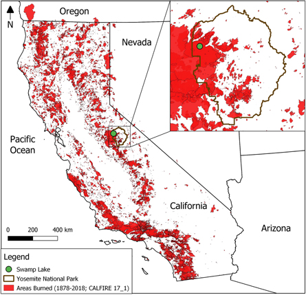
Figure 1. Map of study site. Swamp Lake is located in the Sierra Nevada Mountains of California. Red shading depicts areas burned between CE 1878–2018 (California's Fire Perimeter dataset; available at: http://frap.fire.ca.gov/data/statewide/FGDC_metadata/fire15_1_metadata.xml). The inset shows Swamp Lake's location within Yosemite National Park.
Download figure:
Standard image High-resolution imageMaterials and methods
Sediment core and study site
A Bolivia core was taken from Swamp Lake (37.950 063°N, 119.829 074°, 1550 m a.s.l) in 2007 (Roach 2010, Denis et al 2012). Swamp Lake is located in the central Sierra Nevada Mountains and Yosemite National Park, California, USA. The lake has annually-laminated sediments and is relatively small (surface area = 0.08 km2) with seasonal inlet and outlet streams (Roach 2010, Street et al 2012). The core was split and imaged at LacCore with a Geotek Multi-Sensor Core Logger. Following Vachula et al (2018), minima of red and green color intensities from the Geotek high resolution images (1 pixel ≈ 50 μm) were counted manually to delineate annual laminations (Trauth 2007, Roach 2010). Additionally, dated macrovisual stratigraphic markers (a charcoal lamination, a slump sequence, and two tephras) confirmed the varve-based age-depth chronology (table S1 is available online at stacks.iop.org/ERL/14/104011/mmedia).
Charcoal analysis
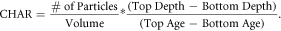
We followed standard procedures to isolate and identify charcoal particles (Whitlock and Larsen 2002, Chipman et al 2015). We volumetrically sampled (0.5–1.0 cm3) wet sediment from contiguous intervals (1 cm) of the core and subjected these samples to a light chemical treatment (sodium hexametaphosphate and bleach; 24 h). Though our age-depth model resolution exceeded that of our sampling scheme, annual sampling was precluded by sediment availability and sampling accuracy. Next, we washed the samples over three nested sieves (63, 150, and 250 μm); with deionized water to isolate size fractions. Using a dissecting microscope (4–40× magnification), we counted charcoal particles in each fraction. Charcoal accumulation rates (CHARs) for each size fraction were calculated using the volumetric concentration and age-depth model (1):
In this letter, we consider the CHARs of two size fractions (63–150 and >250 μm, herein referred to as CHAR63–150, and CHAR250, respectively) to match and benefit from the source area determinations made by Vachula et al (2018). Vachula et al (2018) previously compared CHARs of different size fractions in Swamp Lake with historical fire data and identified the source area of CHAR250 and CHAR63–150 to be 25 and 150 km, respectively (Vachula et al 2018), thus providing a record of local (>250 μm, within 25 km of Swamp Lake) and regional (63–150 μm, within 150 km) area burned. Our new analytical approach allows us to differentiate fire histories of two distinct spatial scales. We compare these CHARs by calculating the linear correlation strength (Pearson's product moment correlation). To enable assessment of centennial-scale trends, raw CHARs were interpolated to the median sampling resolution of intervals (12 years) and smoothed (100 year lowess).
Results
The Swamp Lake record spanned 1431 years, as determined by counting annual laminations in high-resolution core images (figure S1). Our varve-based chronology agreed well with dated stratigraphic markers including a slump deposit, a visible lamination corresponding to a known fire event, and two tephra deposits (see supplementary text and table S1). To construct a fire history, we quantified the CHARs of two size fractions of sedimentary charcoal (63–150 and >250 μm).
Swamp Lake CHARs are inversely related to particle size; CHAR63–150 values (mean = 16.99 cm−2 yr−1; range = 0 to 47.44 cm−2 yr−1) were much greater than CHAR250 (mean = 0.54 cm−2 yr−1; range = 0 to 4.82 cm−2 yr−1; figure 2). Variations in CHARs in these three size fractions were generally positively correlated with one another throughout the record, though the strength of these correlations varied through time and at times the size fractions were inversely correlated. Correlation coefficients (200 year window) between CHAR63–150 and CHAR250 were greatest from ca. 850 to 1350 CE and ca. 1600 to 1900, whereas CHARs were less well correlated before ca. 850 CE and between ca. 1350 and 1600 CE, indicating varying correlations between local and regional fire history. This suggests temporal variations in the factors controlling local and regional fire.

Figure 2. Accumulation rates of charcoal particles (CHARs) 63–150 μm (A), and >250 μm (C) preserved in the Swamp lake sediment core. (B). Correlations (200 year moving window) of these CHARs.
Download figure:
Standard image High-resolution imageDiscussion
Both local and regional fire history is strongly influenced by climate, with warm and dry climates promoting burning. Area burned within 25 and 150 km was greater from 600 to 1500 CE, coincident with generally warmer (Trouet et al 2013) and drier (Cook et al 1999, 2004) climates (figure 3). This finding is in line with previous work demonstrating that warm and dry climates promote burning in the Sierra Nevada (Brunelle and Anderson 2003), potentially via fuel desiccation and subsequently promoted fire ignition and spread. This conclusion disagrees with data suggesting wetter conditions promote fuel accumulation and widespread fires (Norman and Taylor 2003, Beaty and Taylor 2008, Vaillant and Stephens 2009). At centennial and shorter time-scales, climate-fire relationships are more convoluted, particularly at local spatial scales. Comparison of charcoal size classes indicates that although a drier climate from 900 to 1100 and 1200 to 1300 CE promoted both local and regional burning, the dry period from 1350 to 1550 only increased burning at regional scales (figure 3). Similarly, warm temperatures from 1000 to 1200 CE correspond with increased local and regional burning whereas warm temperatures from 700 to 900 and 1650 to 1750 CE appear to have promoted only regional scale burning (figure 3).

Figure 3. Swamp Lake fire history data and paleoclimatological and archaeological datasets. Correlation ((A); 200 year window) of smoothed CHARs (100 year lowess). Periods of spatial heterogeneity are depicted by gray shading. Millennial and centennial changes in temperature ((B); (Trouet et al 2013)) and aridity ((C); (Cook et al 1999, 2004)) generally correspond to variations in CHAR63–150 (D), and CHAR250 (E), which record fire history within 150 and 25 km, respectively. Changes in debitage-based population estimates ((F); (Hull 2009)) correspond to local fire history variations (<25 km) and periods of spatial heterogeneity of fire history. Dashed vertical lines highlight periods of climate-controlled fire activity (red and brown for temperature and aridity, respectively).
Download figure:
Standard image High-resolution imageWhereas climate influenced both local and regional fire history, human land management and fire use was a particularly significant control of local (<25 km) fire history in the central Sierra Nevada during intervals of the last millennium. The Sierra Miwok Native Americans inhabited this area and used fire to promote acorn crops from oak trees (Conrotto 1973, Anderson and Moratto 1996, Gassaway 2009), which served as their primary subsistence resource (McCarthy 1993, Stevens et al 2017). Reconstructions of Miwok population size based on debitage abundance in the Yosemite region also suggest that Native American populations varied considerably in size during the last 1400 years (Hull 2009). These population variations correspond with variations in burning at local scales (within 25 km) at times when the locally derived charcoal size fraction (CHAR250) deviates from regionally sourced charcoal (CHAR63–150). For example, periods of increased local burning corresponded with population maxima from 600 to 900, 1450 to 1700, and 1800 to 1900 CE (figure 3), with particularly distinct state-changes in the Miwok population and fire from 700 to 850, 1475–1525, and 1700 to 1850 CE. These relationships suggest that humans influenced local fire history (<25 km) and caused disconnects between climate and fire, and in the spatial homogeneity of fire history.
The spatial self-similarity, coupling, and decoupling of local and regional fire history evident in the Swamp Lake record are intriguing phenomena. Conceptual models have postulated that the controls of fire are self-similar across a range of spatial and temporal scales (Parisien and Moritz 2009, Whitlock et al 2010). Though some research has sought to characterize the cross-scale dynamics of fire using modern observational data (Díaz-Delgado et al 2004, Falk et al 2007, Slocum et al 2010), relatively little has been done to assess these dynamics on the longer timescales relevant to climate change (Scholl and Taylor 2010, Whitlock et al 2010). Our record indicates that (1) climate changes influenced burning at all spatial scales, (2) Native American influences appear to have been limited to local scales, but (3) high Miwok populations resulted in fire even during periods of climate conditions unfavorable to fires (figure 3). Thus, our record indicates that human alteration of natural fire regimes causes disconnects in the areal self-similarity of fire. Climate, on the other hand, acts as a 'top-down' control on regional fire, which, in the absence of human intervention, cascades down to local scales of fire dynamics. In sum, these cross-scale relationships suggest human management acts as a bottom-up control of fire that can interact with, override, or be overridden by top-down climatic influences.
Both CHAR250 and CHAR63–150 exhibit steady declines over the last 1400 years, in tandem with the development of cool and wet conditions not conducive to burning. These long-term decreasing trends in local and regional fire culminate the 20th century, which experienced the lowest levels of fire activity in the last 1400 years (figure 3). Federal policies suppressed burning in the Sierra Nevada from ca. 1900 to 1970 CE (Taylor and Scholl 2012). This period of suppression is clearly evident in our charcoal record (figure 4). The suppression period experienced warmer and drier climate conditions than the preceding century, yet burning was muted at both regional and local scales (figure 4). This disconnect is thought to have resulted in a subsequent fuel surplus, which has promoted recent burning following the cessation of suppression policies (Caprio and Graber 2000, Westerling et al 2003, Miller et al 2009, Steel et al 2015). However, our data demonstrate recent burning is only remarkable in how limited it has been in the context of the last 1400 years (figure 3). This finding implies that fires have the potential and the precedent to be much more spatially extensive than we have observed in the last century.

Figure 4. Fire, climate, and population history of the last two centuries. Significant deviations of fire-climate relationships occurred during the period of federal fire suppression policy (gray box). Before fire suppression, decadal and annual changes in temperature ((A); (Trouet et al 2013, NOAA 2019)) and aridity ((B); (Cook et al 1999, 2004)) correspond to variations in regional (150 km) and local (25 km) area burned (CHAR63–150 (C) and CHAR250 (D)). Debitage-based population estimates ((E); (Hull 2009)) and the number of recreational visitors to Yosemite ((E); (National Park Service 2018)) correspond to local fire history variations (<25 km).
Download figure:
Standard image High-resolution image
Our data suggest that though human management can influence local fire, a warmer and drier climate controls large-scale area burned. The fire-climate relationships elucidated from our dataset, in combination with projections for warmer and drier climate conditions in California (Hayhoe et al 2004), suggest that future burning in the Sierra Nevada will be more spatially extensive than has been observed in the last century. The legacy of fire suppression, which is clearly evident in our data (figure 3), could further exacerbate fires of the future (Donovan and Brown 2007).
Acknowledgments
This work was supported by a graduate student fellowship and research grant to RSV by the Institute at Brown for Environment and Society. This work was also supported by the National Park Service Shared Beringia Heritage program, Department of the InteriorP18AC00556. We thank A Cheung for helpful discussions and K Brady and LacCore for sampling assistance.
Data availability statement
The charcoal data that support the findings of this study are included within the article. The PDSI (Cook et al 1999, 2004) and paleotemperature (Trouet et al 2013) data are available from the World Data Center for Paleoclimatology: https://ncdc.noaa.gov/paleo. The Yosemite National Park visitor data are available from the National Park Service data store: https://irma.nps.gov. The Yosemite annual temperature data are available from the NOAA National Climatic Data Centers: https://ncdc.noaa.gov.