

Abstract
Latin America has the planet's largest land reserves for agriculture and had the most rapid agricultural expansion during the twenty-first century. A large portion of the expansion replaced forests, as shown by many local and regional studies. However, expansion varied regionally and also replaced other land covers. Further, it is important to distinguish between changes in cropland and pastureland as they produce food at different levels of efficiency and intensity. We used thirteen years (2001–2013) of MODerate Resolution Imaging Spectroradiometer satellite imagery to characterize cropland and pastureland expansion at multiple scales across Latin America. From 2001 to 2013, 17% of new cropland and 57% of new pastureland replaced forests throughout Latin America. Cropland expansion from 2001 to 2013 was less (44.27 Mha) than pastureland (96.9 Mha), but 44% of the 2013 cropland total was new cropland, versus 27% of the 2013 pastureland total, revealing higher regional expansion rates of row crop agriculture. The majority of cropland expansion was into pastureland within core agricultural regions of Argentina, Brazil, Bolivia, Paraguay, and Uruguay. On the contrary, pastureland largely expanded at frontiers, such as central Brazil, western Paraguay, and northern Guatemala. As others have suggested, regional agriculture is strongly influenced by globalization. Indeed, we find an overall decrease in agricultural expansion after 2007, coinciding with the global economic slowdown. The results illustrate agricultural cropland and pastureland expansion across Latin America is largely segregated, and emphasize the importance of distinguishing between the two agricultural systems, as they vary in land use intensity and efficiency.
Export citation and abstract BibTeX RIS

Content from this work may be used under the terms of the Creative Commons Attribution 3.0 licence. Any further distribution of this work must maintain attribution to the author(s) and the title of the work, journal citation and DOI.
1. Introduction
Much of the planet's prime arable land has long been transformed by the plow [1, 2], but population growth and rising consumption exert continuing pressure on land for increased food production [3]. Higher production is possible either by intensification on existing agricultural land or expansion into new areas, and Latin America is the region with the greatest remaining potential for increased expansion5 [5–7]. However, Latin America's sparsely populated rural areas contain some of the planet's most biodiverse [8] and carbon-rich [9, 10] land reserves. Thus, while Latin America can play a key role in future global and regional food security [11], agricultural expansion could have substantial environmental impacts, particularly on biodiversity [12] and carbon emissions [13, 14]. Much of the region's agricultural expansion is relatively recent, as expansion prior to the mid-1900s was limited by land access and technology in some regions [15] and unfavorable climate and soils in others [16]. But improved road infrastructure and green revolution technologies (e.g., new crop cultivars, machinery, fertilizers, pesticides) brought agricultural changes across Latin America.
The 1960s Green Revolution sparked an increase in agricultural production and expansion across Latin America. Since the 1960s, Latin American farmers expanded agriculture faster than anywhere else on the planet. Agricultural area fluctuated during the 1970s and 1980s after a decade of increases in harvested area and production throughout Latin America during the 1960s. Agricultural expansion in Latin America was largely stagnant during the 1990s, although yield improvements continued to raise production. The twenty-first century brought renewed expansion and the largest changes in agriculture area occurred during the 2000s, unprecedented in the region's history until the more recent regional slowdown [17]. Still, agriculture area and production remain unequally distributed (within and among nations) throughout this vast region, with Argentina, Brazil, and Mexico representing the lion's share of both [17]. At the national level, the greatest increases (as a percentage) in harvested area during 2001–2011 occurred in Argentina, Bolivia, Brazil, Guatemala, Paraguay, and Uruguay, and the greatest decreases in Colombia, Cuba, and Mexico [17]. Land cover changes related to this agricultural expansion have been documented in the Brazilian Amazon [18–25], the Bolivian lowlands [26, 27], the Argentine Chaco [16, 28, 29], the Paraguayan Atlantic Forest [30] and Chaco Forest [31, 32], southern Colombia [33], the Lake Maracaibo basin, Venezuela [34], the Yucatán peninsula, Mexico [35], and northern Guatemala [36]. The rapid agricultural expansion in Latin America indicates the region is realizing its vast land potential, with unprecedented growth driven by global food demand for human and livestock consumption [37], currency devaluation [38], policy reform [39], technological and infrastructure improvements [15], land availability [17, 40], and the growing biofuels industry [41]. Pastureland expansion into forests accounted for much of the new agricultural land [18, 19], but recent studies suggest that direct forest to cropland (alternatively, forest-to-pastureland-to-cropland) conversions are becoming more commonplace in some areas [19, 42, 43]. Latin America has more than just forests, though, and its grassland and savanna land reserves have also become hotspots for expansion of row crop agriculture, particularly of maize, soybeans, and sugarcane [17, 26].
Recent literature [19] has drawn attention to cropland/pastureland distinctions at national or regional levels, but continental scale analysis of both cropland and pastureland is lacking. The few studies that have analyzed land use/cover change (LUCC) dynamics at a continental scale have focused on forest changes, and though agriculture has been identified as one of various drivers of LUCC, cropland/pastureland differences have rarely been scrutinized. Agriculture has and will expand into forest and non-forest ecosystems, and the rate of expansion and type of agriculture managed will be increasingly vital for a planet with growing food and climate concerns because cropland and pastureland produce food at different levels of intensity and efficiency.
Data from remotely sensed terrestrial observations continue to improve our understanding of the LUCC consequences of agricultural expansion [44, 45]. Openly available global land cover datasets developed with global classification models [46] are not suitable for regional analysis, though, because they focus solely on deforestation, or only provide a single snapshot in time [45, 47, 48]. A similar gap exists in agricultural LUCC information at the regional scale. Studies have either focused on agricultural changes at a country or smaller scale, or forest cover changes on a larger, regional scale [37, 49, 50]. But to our knowledge no study has assessed twenty-first century agricultural changes across Latin America. The most recent large-scale assessment of agricultural expansion in parts of Latin America used a sample of Landsat-derived land cover changes across the tropics to identify sources of new agricultural land during the 1980s and 1990s [44]. However, the study only reported national-level changes owing to the sampling limitations and could not separate potentially important differences in the dynamics between cropland and pastureland. Moreover, the previous study examined change in the 1980s and the 1990s while our analysis examines the most recent decade that witnessed important LUCC dynamics. The contribution of this paper is a comprehensive, 'wall-to-wall' analysis of recent agricultural LUCC across Latin America, the region that experienced the most rapid changes during the twenty-first century. Our analysis covers one of the most important periods of recent change and also includes the agriculturally important South American Southern Cone (Argentina, Chile, and Uruguay) region, whereas most previous regional studies focused on the Amazon.
2. Materials and Methods
Our objective was to investigate where twenty-first century agricultural land cover changes across Latin America occurred, at national, regional, and subnational, non-political hexagon zones, the rates of changes, and the types of land cover that agriculture replaced. We used region-wide satellite-derived data from the MODerate Resolution Imaging Spectroradiometer (MODIS) to characterize the extent of cropland and pastureland expansion in Latin America for every year from 2001 to 2013. We created annual (2001–2013) land cover maps of Latin America following methods similar to [49] and [51]. We characterized five broad land cover classes (table S1) using high-resolution imagery and predicted them at the MODIS pixel scale (250 m) with a Random Forest classifier [52], using the Random Forest per pixel probabilities to assign land cover classes based on the maximum class probability. We used the same sampling method to collect independent land cover samples for map validation (see SI Materials and Methods, available at stacks.iop.org/ERL/10/034017/mmedia for further details).
Per pixel changes show high inter-annual variability in some areas, though, and annual change results are susceptible to fluctuations from label misclassification. Thus, we analyzed agricultural land cover changes at multiple scales: (1) ecoregions; (2) sub-provincial/state political zones; and (3) sub-political hexagon zones. Ecoregions group common environmental characteristics but are relatively large in scale. We used boundaries defined by the World Wildlife Foundation [53]. Political municipality boundaries provide a smaller scale but vary in shape and size between and among countries. There are over 16,000 political municipality zones across Latin America that range in size from less than 1 km2 to greater than 150,000 km2. Subnational hexagon zones capture sub-political changes while limiting per pixel geo-registration and misclassification errors, and therefore were used to obtain a more consistent comparison across the region. We chose hexagon shaped zones approximating the mean size of all Latin American municipalities ( 1,200 km2).
For zonal trends at each scale, we calculated the area of cropland and pastureland within each zone using the classified MODIS pixel count. Similar to [49] and [51], zones were only considered in the change analysis if either class (cropland or pastureland) represented more than one percent of the zone. That is, land cover was considered present if it represented at least 1% of a zone's total cover. Additionally, annual trends were only assessed if cropland or pastureland was present in four or more years of the time period, and sufficient amounts were present in each third (2001–2004, 2005–2008, 2009–2013) of the time period. Twenty-first century agricultural trends were analyzed per zone with least squares regression models, iteratively chosen among increasing polynomial orders. Following a common statistical approach, outlined in Ray et al [54], we used the Akaike Information Criterion (AIC) of four regression models of area versus time (n = 13): intercept only, linear, quadratic, and cubic. We chose the model with the lowest AIC score to describe change statistics. Then, we determined the model significance using the F-test and p  .01. We computed change trends with the fitted data if the zone had statistically significant change. Net change was calculated from the fitted data end points (e.g., net =
  ) and the annual change rate was computed from the net change (change per year = net/n). Figure S2 illustrates the regression selection procedure and the manner in which land cover trends were computed. Thirteen years of land cover data also allowed us to differentiate between the trends in each half (2001–2007 and 2007–2013, centered around the recent global economic crisis) of the time period.
3. Results
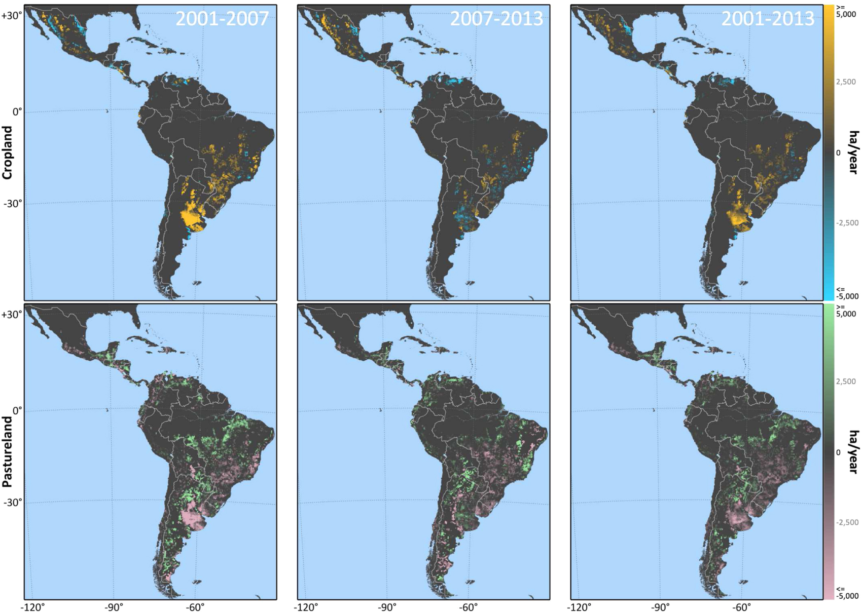
The majority of significant agricultural changes from 2001 to 2013 occurred in a few Latin American countries and replaced disparate land covers. Five key regional characteristics were observed: (1) significant cropland expansion was generally limited to Argentina, Brazil, Paraguay, and Uruguay (figure 1 and S3); (2) there was a post-2007 regional slowdown; cropland and pastureland expanded more rapidly across Latin America during the first half of the time period (from 2001 to 2007, mean of significant cropland zones (1,385 ha yr−1) and pastureland zones (48 ha yr−1)) than in the second (from 2007 to 2013, mean of significant cropland zones (9 ha yr−1) and pastureland zones (22 ha yr−1)) (figure 2); (3) agriculture-led deforestation rates were high outside of the Amazon, in the Dry Chaco Forests (western Paraguay and northern Argentina), Caquetá and Putumayo (Colombia), and Petén (Guatemala); (4) cropland, in addition to pastureland, drove deforestation in eastern Paraguay, central Mato Grosso, and the Argentine Chaco; and (5) new cropland came from non-forested land, particularly in the Argentine Pampas region and in the Brazilian Cerrado.

Figure 1. Cropland and pastureland change dynamics across Latin America (2001–2013). The colors illustrate the change direction, and the hexagon zone relative size represents the annual change rate. Zones shown in black had either insufficient cropland or pastureland, or the 13 yr, least squares polynomial trends were non-significant (p  0.01).
Download figure:
Standard image High-resolution image
Figure 2. Annual change rate (ha/year) of cropland and pastureland. The inset rows illustrate cropland changes (top row) and pastureland changes (bottom row). The inset columns define the timeframes, (left column = 2001–2007, center column = 2007–2013, right column = 2001–2013).
Download figure:
Standard image High-resolution imageIn 2013 there were 101 Mha of cropland and 359 Mha of pastureland within zones of statistically significant change across Latin America (figure 3). 44 Mha of cropland were new cropland, representing 44% of the 2013 total. New pastureland represented a smaller share (27%) of the 2013 total, but a larger area (97 Mha) than cropland. However, national and sub-national agricultural trends varied widely throughout the region, and these details are described below.

Figure 3. Proportion of 2013 cropland and pastureland from different sources in 2001, calculated from hexagon zones with statistically significant change rates. (See table S1 for class details.)
Download figure:
Standard image High-resolution image
3.1. Change by Ecoregions
Brazil's Cerrado and Argentina's Humid Pampas ecoregions witnessed the greatest increase in new cropland, with 9.96 Mha and 6.43 Mha added from 2001 to 2013 (figure S4, I and P). The Alto Paraná Atlantic Forest and Espinal had the third and fourth highest amount of new cropland, at 4.8 Mha and 3.14 Mha, respectively (figure S4, M and O). The Chiquitano Dry Forest in Bolivia had substantially less cropland expansion than other ecoregions, but nearly all cropland in the region (97%) was new expansion over the timeframe (figure S4, J). Lastly, the Uruguayan Savanna region had the highest percentage of cropland expansion from a single source, where 58% percent of all cropland in 2013 was previously pastureland in 2001 (figure S4, Q).
The Cerrado and Dry Chaco had the greatest amount of new pastureland area, with 13 Mha and 11 Mha, respectively (figure S4, I and K). Fifty-five percent of pastureland in the Tapajós–Xingu Moist Forest was new, the highest percentage in Latin America (figure S4, F), followed by the Dry Chaco (48%) and Xingu–Tocantins Araguaia Most Forest (46%) (figure S4, K and G).
Cropland expanded in contiguous ecoregions in Argentina, Brazil, Paraguay, and Uruguay, as well as in the Central American Dry Forests and Mexico's western ecoregions (figure S5). Pastureland expanded in ecoregions around the Amazon periphery and the Petén–Veracruz Moist Forests. The greatest cropland percentage changes occurred in the Uruguayan Savannas and Humid Pampas, whereas pastureland percentage rates were highest in the Brazilian Amazon (figure S6, right column).
3.2. Change by Administrative Units
Argentina—Cropland in Argentina expanded at a steady rate until around 2007, when cropland area stabilized in the four main agricultural ecoregions (figure S7). From 2001 to 2013, 40% of new cropland came from pastureland while the remaining 4% was previously forested (Figure 3). The bulk of significant cropland expansion was around the traditional region, centered on the humid Pampa provinces, Buenos Aires, Córdoba, and Santa Fe (figure 1). This region was predominately cropland in 2001, so most of the expansion was dispersed around the western and southern fringes (figure S8, left map). Thirty percent of all pastureland was new in 2013, with 12% from forest mostly in the northern part of the country and 6% from cropland in the Pampas (figure S8). Cropland expanded most rapidly during the first half of the time period while pastureland expansion remained steady throughout the timeframe (figure S9).
Bolivia—There were 3.71 Mha of new pastureland (17.52 Mha total) in 2013 and 69% came from forests (figure 3). The geographic footprint of cropland expansion was largely limited to the Santa Cruz department. Recent expansion of livestock ranches [55] and displacement of forests occurred closer to the Brazilian border (figure S6).
Brazil—From 2001 to 2013, Brazil added 17.35 Mha of new cropland and 40.54 Mha of pastureland within significant hexagon zones (figure 3). Significant cropland expansion occurred in Mato Grosso, Goiás, matopiba6 , and in southern Mato Grosso du Sol. (figure 1). Cropland expansion coupled with pastureland contraction was present in Mato Grosso, Goiás, and Mato Grosso du Sol, while average annual percentage changes were highest in northern Mato Grosso, with the movement of the front toward the Amazon (figure 2, S6, and S9). Significant pastureland expansion was restricted to the 'Arc of Deforestation' region, particularly in eastern Pará state.
Colombia—New agriculture was almost entirely due to pastureland expansion (4.3 Mha) (figure 3). Significant pastureland expansion in the southwest department of Caquetá (figure 1) led to deforestation over the 13 yr timeframe (figure 2).
Guatemala and Nicaragua—Pastureland expanded significantly in northern Guatemala while cropland expanded in western Nicaragua, between Lakes Managua and Nicaragua (figure 1). In both nations, cropland expanded largely into pasturelands while pastures expanded into forests (figure 3).
Paraguay—Cropland expansion rates were highest in eastern Paraguay (figures 1 and S9). Western Paraguayan pastureland expansion rates were among the highest in Latin America, and the vast majority of new pastureland in 2013 came from forested area (figure S8, right map). Unlike in eastern Paraguay, where few Atlantic Forest remnants remain, Paraguay's western forests have remained largely intact until recent decades, but forest to pastureland conversion accounted for 62% of the 0.82 Mha of new pastureland from 2001 to 2013. In contrast to the post-2007 slowdown of expansion into the Argentine Chaco and the Brazilian Amazon, the western Chaco region was unique in having constant pastureland expansion over the entire time period (figure 2).
Uruguay–Agricultural changes in western Uruguay came in the form of continued cropland expansion and pastureland decreases from the mid-1990s and early 2000s [56]. From 2001 to 2013, the largest cropland increases were in western Uruguay (figure S9). Uruguay's pastureland-dominated landscape meant 79% of new cropland replaced pastureland, which was the largest proportion of pastureland to cropland conversion in Latin America (figure 3).
4. Discussion
4.1. Implications of cropland versus pastureland dynamics
Distinguishing between cropland and pastureland LUCC is important because the two systems vary in land use intensity and efficiency, particularly of food production. The manner in which the two agricultural systems produce food has important implications for food security and conservation. Cropland is typically a more efficient way to produce food than pastureland [57]. Pastures are often extensive systems whereas cropland is a more intensive land use; therefore, cropland produces more calories and protein per hectare. In contrast, pastureland expansion in Latin America has largely been for beef production, the most inefficient way to produce meat [58]. Moreover, during the twenty-first century pastureland expanded in frontier areas, often into intact forests, whereas cropland expanded into previously cleared pastureland. Given these modes of expansion, cropland expansion is relatively more favorable to forest conservation, as it requires less land to meet food demand. Thus, pastureland to cropland conversion intensifies production. Intensification does not always lead to land sparing of other land covers (e.g., forest, grassland), though, and requires appropriate, accompanying policies to be effective [59].
Another important implication of our study is that agricultural expansion does not always mean direct loss of forest cover. Global demand for food, feed, and fiber have not ceased, and the unintended consequences (indirect LUCC) of aiming to avoid deforestation could be increased expansion into ecosystems dominated by non-tree species. Regions with significant pastureland area or expansion could be future hosts to cropland farmers. For example, one of the youngest regions for globally-linked agricultural expansion (e.g., soy, palm oil, rubber) is the Colombian Llanos. It is a largely undeveloped pastureland and savanna region where historically, livestock ranching was the dominant agricultural land use. However, recent trends indicate maize, oil palm, rubber, soybeans, and sugarcane are becoming more widespread [60]. Therefore, future agricultural expansion there will likely come from non-tree land covers. Similarly, the Argentine Pampa and Uruguay's savannas are transforming from livestock dominated landscapes to row crop agriculture. Extensive cattle grazing requires plentiful land, which is cheaper in frontier regions (e.g., the Chaco). The emergence of feedlots in the Pampas has reduced pasture area needed and freed land for cropland conversion [61].
4.2. Drivers of agricultural change
What are the major drivers influencing cropland and pastureland dynamics across Latin America? The region is vast and heterogeneous and LUCC drivers vary widely. Laurance et al [62] recently highlighted major drivers influencing tropical agricultural expansion, and below we assess these drivers in the context of regional LUCC in Latin America.
Global economy—Declined agricultural expansion has been attributed to successful policies, most notably in Brazil [63]. However, post-2007 global economic decline could just as easily be linked to agricultural slowdown, as Brazil was not alone in witnessing the declining rates of agricultural expansion after 2007. Argentina's declining economy plus soaring inflation may have contributed to the documented reduction in the rate of post-2007 cropland expansion in the Pampas and pastureland expansion in the Chaco. The global economy is perhaps the strongest exogenous force driving agricultural expansion in Latin America [15], and the implications of export-oriented agricultural models could have important consequences for the broad array of food security indicators (e.g., supply, access, nutrition). Further research is needed to understand the effects and tradeoffs (e.g., changing diets [64]) of the changing agricultural production modes.
Food and biofuels demand—Beef prices have risen substantially since 2001 [65] and directly impacted the expansion of grazing lands in Colombia, Brazil [66], Bolivia [26], and Paraguay [31]. Consequently, land devoted to soy has risen [17] in order to meet livestock feed demands. Soy has been one of the most widely scrutinized crops in recent decades, and soy intensification and expansion in SA are well documented [67, 68]. Soy can be pinpointed as the main driver of cropland expansion in Argentina, Bolivia, Brazil, Paraguay, and Uruguay, where the highest cropland expansion rates in Latin America occurred. As livestock grazing has moved to interior regions, traditional grazing regions, such as in the Argentine and Uruguayan grasslands, have transformed in part because soy is more profitable. Demand for food, feed, fiber, and biofuels has contributed to agricultural expansion in Latin America [15], although quantification of such linkages is challenging and rare [64].
Policy—The rates of agricultural change declined after 2007, which is in line with policy enacted to invoke fewer land holding pursuits, such as in Brazil. Recent success stories on declining Amazon deforestation rates are promising. The Soy Moratorium—instated to penalize soy production on post-2006 deforested land [63]—was intended to be temporary, though, and a revision of Brazil's Forest Law or changes to protected areas [69] could free land for clearing. Similarly, Argentine Forest Zonation Law was approved in 2007, and could be linked to decelerated expansion in the north. These policy examples were intended to counteract agricultural expansion, but they have a difficult task competing against larger macroeconomic forces and may indirectly affect neighboring states or countries.
Focus on success stories in the Brazilian Amazon potentially overlooks other regions that may have been indirectly affected by deforestation policies, termed 'leakage'. For example, the soy boom in the early 2000s was blamed for the 'push' of livestock ranchers closer to the Amazon frontier [70]. More recently, effects of Brazilian Amazon deforestation policy may have indirectly caused spillover into the Cerrado or neighboring countries. For example, cropland expansion continued in the Cerrado after 2007 when Amazon deforestation rates declined. Brazil's neighboring countries are also attractive places to acquire new agricultural land. Brazilian farmers have migrated to eastern Paraguay [71] and eastern Bolivia [55], for example, where land is cheaper and Brazilian forest laws do not need to be adhered to. Eastern Paraguay continued to bear cropland expansion after 2007. Moreover, internal displacement of farmers and ranchers in eastern Paraguay to the western Chaco [31] is likely a response to the movements of Brazilian farmers.
Technology—Technological advancements have certainly had an impact on agricultural expansion in Latin America. One of the best examples of this is the Brazilian agricultural frontier. Genetically modified soy varieties and cattle bred for tropical climates have been influential in the wave of expansion around the Amazon, particularly in Mato Grosso. Additionally, the introduction of genetically modified soy varieties to Argentine farmers in the 1990s had a profound impact on soy plantings [72].
Population movement—Road infrastructure has improved in certain Latin American regions and affected population migration as well as agricultural transportation efficiency. Agricultural hotspots such as northern Guatemala [36], the Brazilian Amazon [73], and western Paraguay [31] are now more accessible in part to improved road infrastructure. Roads are a major harbinger of population movement and settlement growth. But they are a vital part of the agricultural supply chain as well because they reduce shipping costs and potentially reduce waste from on-farm storage.
5. Summary and conclusion
Clearly, Latin America has a unique combination of land availability and low rural population density. Our findings illustrate recent agricultural expansion occurred throughout Latin America in an age of technologically-driven intensification, but encroachment into forests declined in recent years. Brazil is the regional agricultural behemoth, and regional and global concerns about Amazonian deforestation has likely played some role in slowing agricultural expansion there. However, deceleration of expansion in Brazil does not preclude expansion elsewhere. The dry forests in western Paraguay, in particular, should be of increasing concern. Forest clearing for pastureland in the Chaco has showed no signs of slowing over the thirteen years studied here.
One avenue to reduce future expansion is by intensification. The LAC's agricultural regions have substantial room for yield improvements, particularly for maize and soy [74]. Soils in the traditional regions indicate exhaustion [75], though, which raises doubts on whether increasing yields are sufficient to raise production and reduce expansion. Regardless of whether existing cropland production is intensified, the observed replacement of pastureland by cropland illustrates a regional intensification of agriculture. Policy has shown signs of slowing agricultural expansion, but it is an uphill battle as food, feed, fiber, and fuel demand are incessantly increasing. The recent slowdown in agricultural expansion could be temporary, and if expansion accelerates once again it could have significant impacts on biodiversity, natural ecosystems, traditional farming, and indigenous land rights.
Acknowledgments
The authors thank Nora Alvarez-Berríos for her time spent on image interpretation. We would also like to thank two anonymous reviewers for their insightful comments. This research was supported by grant 0709598 from the National Science Foundation to TM Aide and grants from the Moore Foundation and from the National Science and Engineering Research Council of Canada to N Ramankutty.
Footnotes
- 5
In Latin America, 1,095 Mha of 2,022 Mha is considered suitable based on data from [4]. This is only slightly higher than sub-Saharan Africa (1,073 Mha of 2,281 Mha).
- 6
This region is named after the four neighboring Brazilian states, Maranhão, Tocantins, Piauí and Bahia.