


Abstract
Projected climate and environmental change are expected to increase the pressure on global freshwater resources. To prepare for and cope with the related risks, stakeholders need to devise plans for sustainable management of river systems, which in turn requires the identification of management-appropriate operational units, such as groups of rivers that share similar environmental and biological characteristics. Ideally, these units are of a manageable size, and are biotically or abiotically distinguishable across a variety of river types. Here, we aim to address this need by presenting a new global river classification framework (GloRiC) to establish a common vocabulary and standardized approach to the development of globally comprehensive and integrated river classifications that can be tailored to different goals and requirements. We define the GloRiC conceptual framework based on five categories of variables: (1) hydrology; (2) physiography and climate; (3) fluvial geomorphology; (4) water chemistry; and (5) aquatic biology. We then apply the framework using hydro-environmental attributes provided by a seamless high-resolution river reach database to create initial instances of three sub-classifications (hydrologic, physio-climatic, and geomorphic) which we ultimately combine into 127 river reach types at the global scale. These supervised classifications utilize a mix of statistical analyses and expert interpretation to identify the classifier variables, the number of classes, and their thresholds. In addition, we also present an unsupervised, multivariable k-means statistical clustering of all river reaches into 30 groups. These first-of-their-kind global river reach classifications at high spatial resolution provide baseline information for a total of 35.9 million kilometers of rivers that have been assessed in this study, and are expected to be particularly useful in remote or data-poor river basins. The GloRiC framework and associated data are primarily designed for broad and rapid applicability in assessments that require stratified analyses of river ecosystem conditions at global and regional scales; smaller-scale applications could follow the same conceptual framework yet use more detailed data sources.
Export citation and abstract BibTeX RIS

Original content from this work may be used under the terms of the Creative Commons Attribution 3.0 licence. Any further distribution of this work must maintain attribution to the author(s) and the title of the work, journal citation and DOI.
Introduction
Environmental managers, practitioners, and stakeholders are frequently challenged to deal with a multitude of pressures, risks, and threats that put the integrity of ecosystems in jeopardy. They are faced with the need to find increasingly innovative and complex solutions that support sustainable development and foster the coexistence of ecosystems and human society (Ostrom 2009, Rockström et al 2009, Gerten et al 2013). In response, a common approach taken by resource managers and conservation planners is to identify unique spatial management units upon which, for example, river health assessments can be completed or individual management strategies can be developed (Brierley 2000, Olson et al 2001, Revenga et al 2005, Rinaldi et al 2016). In the freshwater realm, spatial units are often represented as river reaches (here defined as stretches of rivers between two tributaries) that are grouped into classes or types.
River classifications can provide opportunities to better understand river ecosystems and their function, highlight similarities or differences between climatic or physiographic regions, allow for international comparisons of freshwater resources, enable assessments of the representation of system types in protected area networks, and frame other analyses (Metzger et al 2013). River reach types can also represent coarse proxies for biodiversity patterns where biological or species data are unavailable (Poff et al 1997, Higgins et al 2005), and can provide a mechanism to extrapolate information, such as river regime types, across river classes with similar characteristics (Rosgen 1994).
Several global river classifications have been developed in the past (Haines et al 1988, Puckridge et al 1998, Poff et al 2006, Fernandez and Sayama 2015), but, to our knowledge, none exist that have a consistent and seamless global coverage at the resolution of individual river reaches and that are suitable for multidisciplinary approaches. For example, Haines et al (1988) defined 15 generalized river types around the world by mapping them as contiguous river regions, mostly determined by hydrologic differences. Poff et al (2006) and Puckridge et al (1998) classified rivers using hydrologic station data, but only those rivers that are monitored were assigned a river type, leaving the majority of rivers at the global scale unclassified. Similarly, Fernandez and Sayama (2015) classified 35 large river basins, but their analysis was not globally comprehensive.
Existing river classifications also vary widely in the selection and inclusion of classification parameters (Melles et al 2014). The diversity of approaches makes the interpretation of the findings from these studies difficult as the resulting classes typically do not represent the same characteristics from one analysis to another. These inconsistencies highlight the need for standardization in the variables included to inform potential comparisons among the classifications.
In this paper, we first introduce the new conceptual Global River Classification framework GloRiC. The main goals of the GloRiC framework are (a) to provide a scheme that allows for clear articulation and explanation of the primary criteria used in the classification, and (b) to identify a common set of river system characteristics that can be used for global and regional scale classification efforts. We then apply the GloRiC conceptual framework utilizing a standardized and globally comprehensive database of river reach attributes to produce three sub-classifications based on hydrologic, physio-climatic, and geomorphic characteristics. Statistical analyses and expert opinion are used in a supervised approach to select the variables to be included in the three sub-classifications, and to establish the number of classes and thresholds between them for each variable. Finally, the results from the three sub-classifications are combined into a simplified global classification of 127 environmentally distinct river reach types. Acknowledging that the supervised classification approach is subjective in its use of expert opinion to decide (1) which variables are deterministic, and (2) what the number of classes should be and how they are separated, we also performed an unsupervised k-means statistical clustering of the data to produce 30 global river reach types. The data and maps produced from the classifications and clustering analyses provide baseline information for all global rivers and are intended to inform management applications designed to sustain global river systems.
The GloRiC framework
GloRiC approach and categories
The GloRiC framework draws from landscape ecology theory (Wiens 2002), the riverscape concept (Fausch et al 2002, Carbonneau et al 2012) and environmental flow principles (Poff et al 1997, Richter et al 1997, Arthington et al 2006) in that all three concepts emphasize the importance of a multi-scale approach to river characterization. This is particularly true for the landscape ecology and riverscape concepts, in which river habitat characteristics are perceived to be the result of processes interacting at various spatial and temporal scales (i.e., ranging from micro-habitat morphology to climatic patterns) which in turn lead to an associated diversity of species and habitat within a reach (Tonn et al 1990). The development of aquatic classifications (including lakes, watersheds and rivers) has also been viewed as being either 'top-down' (divisive) or 'bottom-up' (agglomerative) (Kingsford et al 2005) and the choice of classification approach is application specific (Frissell 1986, Naiman et al 1992, Fausch et al 2002).
The GloRiC framework was conceptualized based on a systematic review of 60 river classifications that used abiotic and biotic classifier variables, ranging from watershed to global scales (see SI-section 1, available online at stacks.iop.org/ERL/14/024003/mmedia). In total, these classifications contained 633 individual classifier variables, of which 193 were unique. Based on a qualitative analysis of the compiled variables, GloRiC proposes a consistent scheme for separating potential classifier variables into one of five thematic categories, allowing for a multidisciplinary characterization of the river reach (figure 1). Each category represents key river system characteristics as determined by hydrology, physiography and climate, fluvial geomorphology, water chemistry, and aquatic biology. The five categories are intended to offer two application pathways: they can either serve to develop five individual baseline sub-classifications; or they can offer a versatile mix-and-match framework with which to compose multiple, hierarchical levels of sub-classifications and combined classifications that broadly satisfy different goal-oriented needs, such as those created to support the assessment of environmental flow requirements (Bejarano et al 2010, Belmar et al 2011, Mackay et al 2014). The first four categories and associated sub-classifications represent various abiotic aspects of river reaches, and we propose that they can be combined to create physical 'river reach types' representing reaches with similar environmental potential and resources. Aquatic biology could then either be integrated with the abiotic classification to examine biotic responses to physical environmental potential, or be treated as a separate level of stratification.

Figure 1. Five categories of classifier variables forming the conceptual basis of the GloRiC framework. The four abiotic categories of hydrologic, physio-climatic, geomorphic, and chemical variables can be used to define physical river reach types.
Download figure:
Standard image High-resolution imageGloRiC spatial units
River ecosystems differ greatly from their terrestrial counterparts in their accumulating nature. Flow quantities, the annual flow regime, or water chemistry are examples of characteristics that are propagated and accumulated along the river network. For example, land cover in the headwater area may affect the chemical composition of downstream water (Tetzlaff and Soulsby 2008, Withers and Jarvie 2008). To create a river classification, it is thus essential to include an upstream/downstream perspective and to be able to trace connections and network topology. In general, hydrologic and chemical variables may be more appropriately treated with a cumulative upstream watershed perspective, while physio-climatic and biological variables may be better suited to a local perspective. Geomorphologic properties of river reaches may derive from both local and upstream sources.
To acknowledge this inherent feature of fluvial systems, GloRiC considers rivers as connected, networked, linear features, and emphasizes the river itself as the primary spatial entity, rather than the (sub-)basins through which rivers flow. GloRiC identifies river reaches as the smallest spatial unit. The advantage of using reaches is that they can represent conditions along the reach itself; the immediate surroundings of the contributing sub-catchment for each individual reach; or the entire upstream watershed that contributes to the specific reach (figure 2). In contrast, using sub-basins as the primary spatial entity would limit or preclude the use of hydrological or fluvial geomorphology characteristics relating to the stream channel itself. Moreover, many sub-basins contain multiple river reaches that differ substantially, ranging from small tributary reaches originating within the sub-basin to larger main stem reaches traversing the sub-basin. Lumping heterogeneous reaches within a single sub-basin convolutes the understanding of the effective spatial resolution of the analysis.

Figure 2. Differences between river reach, contributing sub-catchment, and upstream watershed as spatial units of analysis. A river reach is defined as a segment of a river located between two tributaries or between a tributary and the start (source) or end (sink, delta) of a river. The contributing sub-catchment pertains to the area that contributes only and directly to this river reach. The upstream watershed relates to the entire upstream area that is hydrologically connected to this reach. In the case of headwater reaches, the reach catchment and upstream catchment are the same.
Download figure:
Standard image High-resolution imageInput data and methods
River reach geometry and attribution
Application of the GloRiC framework to develop a new, standardized, high-resolution global classification of river reaches required a spatially explicit and consistent database of both river geometry and descriptive hydro-environmental attributes. The HydroSHEDS database (Lehner et al 2008) is widely considered to be the most consistent river reach dataset currently available at the global scale (SI-section 2). HydroSHEDS was thus selected to provide the spatial foundation of GloRiC at 15 arc-second resolution (i.e. the river reaches were extracted from pixels measuring approximately 500 m × 500 m at the equator). Rivers were derived in HydroSHEDS for all locations where the long-term average discharge exceeds 100 liters per second or the upstream catchment area exceeds 10 km2, resulting in a total global river length of 35.9 million kilometers. Smaller rivers were omitted to avoid increasing uncertainties due to errors in very small spatial units, either in HydroSHEDS or in auxiliary global data. Rivers are broken into reaches at all confluences, creating approximately 8.5 million individual river reaches with an average reach length of 4.2 km (std. dev. = 4.8 km).
The geospatial river network data of HydroSHEDS is accompanied by a companion database, termed RiverATLAS, which provides a compendium of hydro-environmental attributes that were derived from existing global datasets and assigned to each river reach of HydroSHEDS (SI-section 2). RiverATLAS offers an open and readily available registry from which pre-calculated attributes were selected or new ones calculated to serve as the variables in developing GloRiC's sub-classifications and river reach types.
Supervised classification approach
In order to create a first instance of global river reach types through supervised classification, we applied the GloRiC conceptual framework to the global river reach data and used statistical analyses to guide our decisions. First, we extracted a subset of river reach attributes that are commonly used in river classifications from the RiverATLAS database and derived an initial set of three sub-classifications (hydrologic, physio-climatic, and geomorphic). We could not create a chemical or biological sub-classification due to lack of reliable and consistent global data.
Our general classification approach is modeled after Olden et al (2012), and is based on (1) reducing the dimensionality of the data by screening potential input variables and selecting a subset of them to use as classifiers, and (2) subsequently implementing the classification. For the supervised classification, we reduced an initial set of classifier variables selected based on the systematic literature review using a principal component analysis (PCA) and a correlation matrix (SI-section 3).
After selecting the classifiers to be used, we derived the number of classes and class separation thresholds for each of the selected variables. The aim in this classification step was to identify a relatively low number of classes for each variable that reasonably represents natural groupings and major environmental features and avoids over-partitioning of the subsequent general global river reach types. A second goal was to use simple, replicable rules to increase the transparency of class separation. Class numbers and their value ranges were thus determined primarily by examining the statistical distribution of the values and separating them into quantile-based groups of either three, four, or five classes. The choice of using quantile-based groupings was informed by k-means clustering (SI-section 4).
The final step in the supervised classification was to combine the resulting classes from the three sub-classifications into one set of standardized, environmentally distinct global river reach types. The ultimate number of desired classes or types from any classification of geographic entities is a difficult consideration and there is almost always a trade-off between the representativeness (leading to a large number and a wider range of representation) and the manageability (prioritizing a lower number and reduced heterogeneity) of classes (Poff et al 2010). For the creation of global river reach types, we prioritized fewer, more generalized river reach types and aimed at keeping the number between 30 and 200. We believe that this range can depict both large-scale patterns, such as topography and climate, and finer scale patterns, such as flow regime magnitude and stream power, while still being manageable for global assessments or comparisons. To limit the number of resultant class-combinations from the three sub-classifications, we followed the approach of Sayre et al (2014) who proposed to first reduce the number of classes found in each sub-classification before combining them (SI-section 4).
Unsupervised clustering approach
In addition to the supervised classification exercise, we sought to reduce reliance on expert interpretation by implementing a second, more objective grouping of global river reach types. We therefore executed a multidimensional, unsupervised clustering of the data using an aspatial (not spatially constrained), all variables included, k-means clustering. The variables included in this multivariable clustering were the same set of variables used to develop the three sub-classifications described above.
K-means clustering was used because it can identify similarities across a large, multidimensional data space (Legendre and Legendre 2012). Variables were normalized and centered prior to their use in the k-means clustering algorithm. We used the simple structure index (Dolnicar et al 1999) to identify the most efficient partitioning solutions of k-means clustering between 30 and 200 final classes.
Results
Hydrologic sub-classification
For the hydrologic sub-classification, two variables were selected through PCA (table 1): the long-term average discharge and a flow variability index, defined as the ratio of the highest average monthly discharge and the long-term average discharge. These two variables corresponded with the first two principal component axes, representing 83.1% and 6.4% of the variance, respectively. We divided the long-term average discharge into five logarithmic size ranges and the flow variability index into three ranges of variability (figure 3 caption for details). The combination of these ranges resulted in 15 hydrological classes (figure 3).
Table 1. List of variables included in the analysis. More details on the nature and the quality of the datasets used are found in SI-section 2.
| Sub-classification | Variables considered and selected | Datasets used and their main characteristics |
|---|---|---|
| Data sources: WaterGAP (Döll et al 2003) and HydroSHEDS (Lehner et al 2008) | ||
|
A climatology (i.e., long-term averages) of monthly discharges is available for all reaches of the HydroSHEDS river network at 500 m resolution. These were derived from the global hydrological model WaterGAP (Döll et al 2003; model version 2.2 as of 2014). WaterGAP data were spatially downscaled from their original 0.5 degree pixel resolution (~50 km at the equator) to the 15 arc-second (~500 m) resolution of the global HydroSHEDS river network (Lehner et al 2008) using geo-statistical approaches (Lehner and Grill 2013) | |
|
||
|
||
| Hydrologic |
|
|
|
||
|
||
| Data sources: SRTM (Farr et al 2007) and HydroSHEDS (Lehner et al 2008) | ||
|
Average hillslope was calculated using a 10 km buffer around each reach | |
|
Data sources: WorldClim (Hijmans et al 2005) | |
|
WorldClim provides data in grid format at 30 arc-second resolution (approximately 1 km at the equator) | |
|
||
| Physio-climatic |
|
|
|
||
|
Data sources: Global-PET (Zomer et al 2008, Trabucco and Zomer 2009) and WorldClim (Hijmans et al 2005) | |
| The CMI was calculated at 30 arc-second resolution as '(precipitation/potential evapotranspiration)-1' as defined by Willmott and Feddema (1992) using mean annual potential evapotranspiration from the Global-PET datasets and mean annual precipitation from WorldClim | ||
|
Data sources : HydroSHEDS (Lehner et al 2008) | |
| Calculated as the maximum minus the average elevation of the reach, divided by half the length of the reach | ||
|
Data sources: HydroSHEDS (Lehner et al 2008) and WaterGAP (Döll et al 2003) | |
| Geomorphic | Total stream power is calculated as the product of the maximum long-term average monthly discharge from HydroSHEDS and the average stream gradient of the reach | |
|
Data sources: Global Lakes and Wetlands Database GLWD (Lehner and Döll 2004) | |
| Lake-wetland influence was calculated as a binary index where reaches that were located partly or totally inside a lake or wetland zone from GLWD would get a value of one. We used all of the classes from GLWD as lake-wetland indicators | ||
aApplied as logged values in the analysis (PCA and k-means clustering). bIncluded in the final clustering for GloRiC.

Figure 3. Hydrologic sub-classification of river reaches at the global scale. This sub-classification has 15 different classes based on long-term average discharge magnitude and a flow regime variability index. Classes are sorted in five levels of discharge magnitude: very low (VL Q; 0.1–10 m3 s−1), low (L Q; 10–100 m3 s−1), medium (M Q; 100–1000 m3 s−1), high (H Q; 1000–10000 m3 s−1), and very high (VH Q; >10000 m3 s−1) and three levels of the flow variability index: low (L Var; <2), medium (M Var; 2–3), and high (H Var; >3). Plots (A)–(C) show the frequency distribution, discharge distribution, and different flow variabilities, respectively, of the resulting classes (with box plots of (B) and (C) showing average, standard deviation, and first and third quartiles).
Download figure:
Standard image High-resolution imageThe hydrologic class with the highest number of reaches is 'very low discharge, high variability' with more than 2.6 million river reaches. The resulting classes show a differentiation between more arid and more humid climatic zones. Large extents of arid and semi-arid areas such as the Sahara and Gobi deserts, Australia, and the American Prairies are dominated by the 'very low discharge, high variability' river class. River reaches located in large equatorial basins such as the Congo and the Amazon, as well as in large wetland complexes such as in Canada, Indonesia and Papua New Guinea are mostly classified as 'very low discharge, medium variability'. Note that some ephemeral reaches have no average flow (e.g., central Sahara, Atacama Desert) and are excluded from further analysis.
Physio-climatic sub-classification
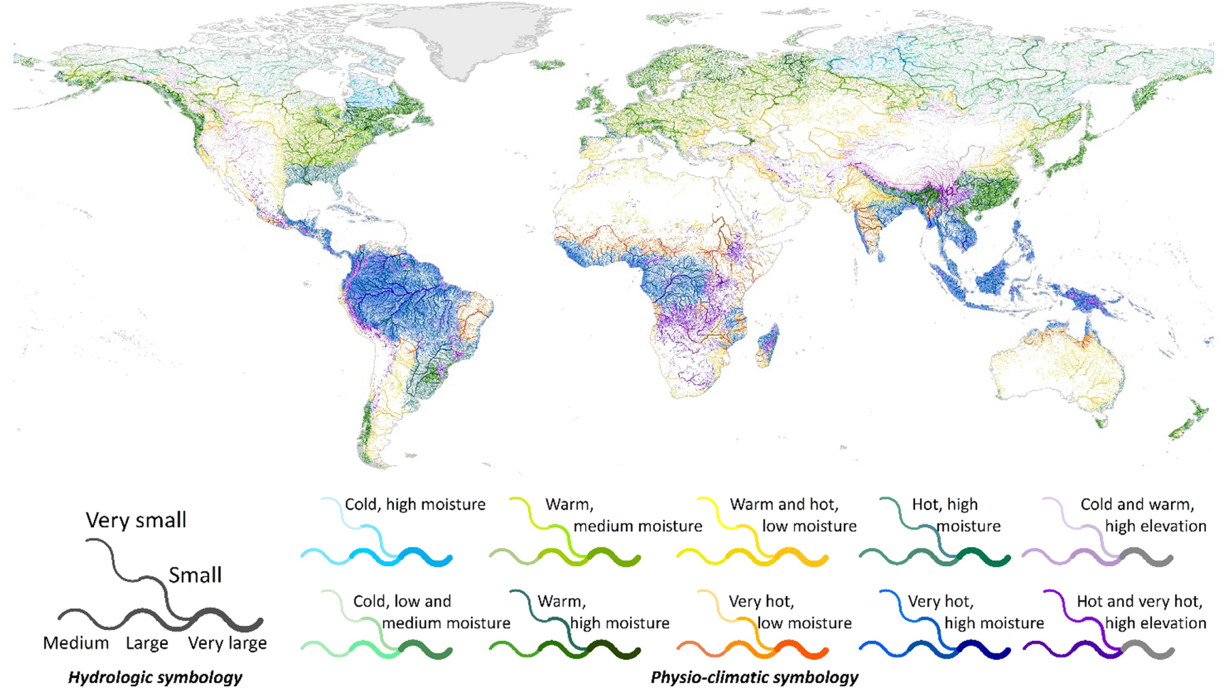
For the physio-climatic sub-classification, the first three main axes of the PCA, together representing 89.0% of variance, were associated with the long-term average of the minimum air temperature of the coldest month (52.3%); the climate moisture index (CMI) (23.9%); and elevation (12.8%). We divided the long-term average of the minimum air temperature into four ranges, the CMI into three ranges, and the elevation into two ranges (figure 4 caption for details). The combination of these ranges resulted in 24 physio-climatic classes (figure 4).

Figure 4. Physio-climatic sub-classification of river reaches at the global scale. This sub-classification has 24 different classes based on minimum air temperature, climate moisture index, and elevation. Classes are sorted in four levels of the long-term average of the minimum air temperature of the coldest month: low (L Temp, < −20 °C), medium (M Temp; −20 °C–5 °C), high (H Temp; 5 °C–20 °C), and very high (VH Temp; > 20°C); three levels of the climate moisture index: low (L CMI < −0.4), medium (M CMI; −0.4–0.125), and high (H CMI; > 0.125); and two levels of elevation: low (L Elev; <= 750 m) and high (H Elev; > 750 m). Plots (A)–(D) show the statistical distributions of frequency, long-term minimum air temperature, climate moisture index, and elevation, respectively, of the resulting classes (with box plots of (B)–(D) showing average, standard deviation, and first and third quartiles).
Download figure:
Standard image High-resolution imageThe physio-climatic classes are generally similar to existing global climatic zonations, such as the Köppen–Geiger climatic regions (Peel et al 2007), yet regional topography exerts a strong influence in certain areas. This distinction from typical global terrestrial climate characterizations is important for a river-centric classification considering the importance of smaller-scale hillslopes on hydrology and sediment influx in river systems. The groupings show large, relatively homogenous areas of 'high or very high temperature, low moisture index, low elevation' in Africa, Australia, and the Middle East. Regions of 'very high temperature, medium or high moisture index, low elevation' are prevalent in Brazil, the Congo Basin and South-East Asia. Broad areas of the north are grouped into 'low temperature, low elevation' classes of varying moisture.
Geomorphic sub-classification
Of the three variables for the geomorphic sub-classification for which consistent global data at high spatial resolution were available (total stream power, lake-wetland influence, and stream gradient; table 1), we chose not to use the stream gradient because of its inclusion in the calculation of stream power. Given the limited number of remaining variables, no PCA was necessary for this sub-classification. The lake-wetland influence and the stream power were divided into two ranges each (figure 5 caption for details). This resulted in a combination of four geomorphic classes (figure 5).

Figure 5. Geomorphic sub-classification of river reaches at the global scale. This sub-classification has four different classes based on total stream power and lake-wetland influence. Classes are sorted in two levels of stream power: low (L; <= 1 kW/m2) and high (H; >1 kW/m2) and two levels of lake-wetland influence: no lakes or wetlands (0), and lake-wetland influenced (1). Plots (A)–(C) show the statistical distributions of frequency, stream power, and lake-wetland influence, respectively, of the resulting classes (with box plots of (B) and (C) showing average, standard deviation, and first and third quartiles).
Download figure:
Standard image High-resolution imageDue to the general global lack of river geomorphology data, the geomorphic sub-classification does not represent traditional classes of fluvial river morphology. Nevertheless, it successfully separated several large-scale distinctions, such as the vast extent of wetland-dominated areas in Canada and Alaska and low stream power areas in arid regions.
Global river reach types from supervised approach
The direct combination of classes produced from the three sub-classifications (15, 24, and 4 possible classes from the hydrologic, physio-climatic, and geomorphic sub-classifications, respectively) yielded 1039 (out of 1440 possible) unique river reach types. As this number exceeded our targeted number of classes (between 30 and 200), we reduced the number of classes found in each sub-classification before combining them. The hydrology classes were reduced from 15 to five by using only the long-term average discharge ranges. The physio-climatic sub-classification was reduced from 24 classes to ten by merging all high elevation classes into two (cold and hot high elevation) and combining other similar classes. The geomorphic classes were reduced from four to three by merging the low and high stream power classes where lakes or wetlands are present. Also, after combining the sub-classifications, we refrained from distinguishing geomorphic classes for all rivers with 'very high discharge' according to the hydrologic sub-classification. This reduction resulted in a total of 150 possible (5 × 10 × 3) aggregated river reach combinations of which 127 were realized in the final typology (figure 6; SI-section 5).

Figure 6. Global river reach types based on supervised classification. This map shows 127 river reach types derived through manual simplification and combination of the hydrologic, physio-climatic and geomorphic sub-classifications. The legend illustrates only basic hydrologic (varying line thickness, gray symbology) and physio-climatic variations (colored symbology), but each of the 127 river reach types on the map was attributed a different color. For a full legend and zoomed figures see SI-section 5.
Download figure:
Standard image High-resolution imageThe most common river reach type globally is 'small river with low stream power and no presence of lakes or wetlands in very hot and high moisture climate' (20.8% of all reaches), followed by 'small river with low stream power and no presence of lakes or wetlands in warm and hot, high moisture climate' (11.5%). It should be noted, however, that arid and semi-arid river reaches may include many intermittent or ephemeral streams that do not flow for long periods of time, hence their actual extent at any one point in time is likely less dominant.
Global river reach types from unsupervised clustering
The k-means clustering resulting in 30 classes was chosen as the final clustering solution (figure 7). While at the low end of the range of investigated cluster number solutions, we chose this outcome to obtain a smaller number of natural groupings than we had identified in the supervised classification exercise (127). We felt that a smaller number of objectively-produced classes might be more relevant for freshwater management at a global scale. As the k-means clustering approach does not deliver explicit class thresholds, we refrain from translating the 30 numeric classes into more meaningful descriptions of dominant characteristics. However, in the clustering solution the influence of physio-climatic gradients is evident in the spatial pattern of rivers with smaller long-term average discharge. These small rivers are grouped into climatic regions based mostly on temperature and aridity. Unlike the supervised classification approach which yielded numerous types of large rivers, in the unsupervised clustering approach there was little separation of larger rivers into specific types. The most common class is number 11 representing 7.4% of all river reaches. This class correlates strongest with rivers with small and medium long-term average discharge in hot, humid areas.

Figure 7. Global river reach types from k-means clustering. This map shows 30 statistically distinct river reach types based on all hydrologic, physio-climatic and geomorphic variables that were selected in the supervised sub-classifications. To improve visual clarity, line thickness is proportional to average discharge, but only the colors represent the classification.
Download figure:
Standard image High-resolution image
Discussion
The GloRiC framework
Fluvial and terrestrial ecosystems are different in terms of the processes that shape their respective habitats. While physio-climatic characteristics are often the basis for terrestrial or landscape classifications, hydrology and fluvial geomorphology are major driving factors for river systems in terms of habitat creation and disturbances. These latter two aspects of river reach types are crucial to the biota of fluvial environments and are explicitly covered in the GloRiC framework. As such, this framework represents a powerful communication tool that allows for a common vocabulary across river classifications. The flexibility of the GloRiC framework also supports and promotes the development of alternative, application-specific sub-classifications which could exploit the standardized and readily available attribute information offered in the RiverATLAS database.
The GloRiC framework provides an interdisciplinary approach to the classification of rivers and allows for rapid testing of the effects of parameter inclusion and omission. The inclusion of classifier variables that are derived both at the reach level (e.g. temperature) and with an upstream perspective (e.g. discharge) provides a landscape-integrated multi-scale perspective.
Global river reach types
Our implementation of the GloRiC framework at the global scale using HydroSHEDS and RiverATLAS data delivered a spatially explicit set of 127 river reach types based on supervised expert classification, and 30 river reach types based on unsupervised statistical clustering. Both approaches represent characterizations and groupings of river reaches derived from hydrologic, physio-climatic and geomorphic properties. The availability of seamless georeferenced lines and attribute information for nearly 8.5 million river reaches represents an unprecedented spatial resolution for a river classification at the global scale. The resulting classifications allow for comparison across continents and provide a standardized baseline of different river reach types that can be used in a wide range of applications.
The geographical distribution of the resulting river reach types reflects general patterns at the global scale that are similar to coarser global eco-regionalizations, such as the 14 terrestrial biomes defined by Olson et al (2001), or the freshwater ecoregions of the world by Abell et al (2008). However, the inclusion of hydrologic variables, and in particular discharge magnitude, as well as a stronger focus on small-scale topography introduce a new geographic differentiation related to flow and local terrain heterogeneity.
Limitations
River classifications to date have tended to focus on hydrologic variables (SI-section 1). Typically applied at local to regional scales, these classifications often rely on daily discharge data, which allows them to depict many specific characteristics of the river regime such as timing, rate of change, and recurrence (Melles et al 2014). In the absence of daily discharge data, the global river reach types presented here rely instead on long-term average monthly discharge. This limitation renders the results less specific and more limited to represent baseline conditions only. Nevertheless, the multidisciplinary GloRiC framework allows the inclusion of additional river characteristics based on physiography, climate and fluvial geomorphology to capture holistic patterns and elements of variability not covered by hydrology alone.
The presented first application of GloRiC does not include chemical or biological sub-classifications as proposed by the full framework, simply due to the lack of globally available and consistent data. Variables commonly used to represent the water chemistry of rivers, such as pH levels, salinity, or oxygen content are currently not available globally at high spatial resolution. Water temperature, however, may be partially reflected in the physio-climatic sub-classification. Similarly, the absence of biological data precludes the identification of regional differences in biodiversity patterns, such as distinct species assemblages—even for the same environmental river reach types—in different basins.
Any attempt to classify rivers at a global scale is dependent on available data. This first application of the GloRiC framework is based on globally comprehensive source datasets, which are typically less precise and accurate than locally available data. The datasets used to compile the global RiverATLAS compendium have certain limitations and uncertainties that need to be considered (SI-section 2). Particular caution is advised when using classes resulting from the hydrologic and geomorphic sub-classifications for smaller river reaches (0.1–1 m3 s−1), as these are increasingly uncertain in the coarse-scale global model calculations. For projects undertaken at smaller scales, the GloRiC framework could be extended by incorporating data at finer spatial and temporal resolutions.
One of the main goals of this analysis was to derive a manageable number of final river reach types while capturing a wide variety of types across the globe. To achieve this goal, it was necessary to merge some similar classes. Hence, by design, the results of this analysis tend to highlight broad classes and omit rare or exceptional river reach types. For this reason, we caution against using the global river reach types in conservation planning efforts that emphasize the identification of rare habitat types. The GloRiC framework could, however, be applied to derive a greater number of river reach types if needed in other applications.
Applicability and evaluation
The GloRiC framework and underlying data have previously been used to create a classification of river reach types in the Greater Mekong Region (Lehner and Ouellet Dallaire 2013). We consulted with local experts during the process to select the best data for the region. In this data-poor area, the global datasets were well-suited given their consistency across political borders and high spatial resolution, demonstrating the advantage of using standardized global data when local data are scarce. During this Greater Mekong project, we found that the GloRiC framework provided a clear conceptual framework to easily identify the characteristics of the river systems that were deemed critical by the group of local, interdisciplinary experts.
Moreover, as a preliminary evaluation of our global results, we compared the output from the supervised classifications with classes from two regional river classifications located in Australia (Stein et al 2009) and in Spain (Belmar et al 2011). This preliminary evaluation indicated that the global application of GloRiC is capable of identifying patterns that are discernable at regional scales. Details of these comparisons are presented in SI-section 6.
Future work comparing the results of our global supervised classification with the results from our k-means or other unsupervised, aspatial, statistical clustering is encouraged. For example, it would be informative to implement clustering using statistical stopping rules (e.g. Metzger et al 2013) where the optimum number of clusters produced is a function of the intrinsic variability of the data, providing an instance of a completely unsupervised classification. As it stands, our unsupervised k-means clustering offers a novel, objective characterization of global river reaches for further evaluation by the river classification community.
Conclusion
GloRiC aims to provide a conceptual framework for the environmental characterization of global river reaches. GloRiC is a communication tool that allows freshwater scientists to distinguish between and explain the differences among existing river classifications by providing concrete examples of potential characteristics to be included, and it lays the groundwork for a comprehensive, standardized definition of major global river reach types. GloRiC does not seek to prescribe an exhaustive list of all possible river characteristics but rather provides a modular, flexible, organizing framework that integrates the different types of variables that shape the character of freshwater systems.
A defining feature of GloRiC and its first application to derive river reach types at a global scale is its high spatial resolution (500 m). This high resolution enables the use of variables such as stream power or stream gradient at the reach level; neither variable was included in earlier global river classifications. As such, this first implementation of GloRiC provides unique, first-of-its-kind information for every river reach of the global river network, comprising a total length of 35.9 million kilometers.
The GloRiC framework, the associated RiverATLAS database, the three sub-classifications and the maps of 127 and 30 global river reach types can be utilized in many contexts related to aquatic ecosystem assessments and freshwater resource management at large scales. For example, the resulting multidisciplinary river reach types can aid in conservation planning by guiding the identification of river types that are not represented or under-represented in the current global protected area system. Moreover, the science of environmental flow requirements continues to grow to include a wider range of disciplines and its applications often require river classes. The GloRiC framework could support this evolution due to its multidisciplinary nature, especially in large-scale settings.
This work represents a consistent classification of river systems that can form the basis for international and intercontinental comparisons. Because of the inherent consistency of methods and data, the hydrologic, physio-climatic, and geomorphic sub-classifications, as well as the combined river reach types can serve as a reference resource for environmental assessments of global rivers.
Finally, the global river reach types and their spatial distribution can inform studies of human alteration of river ecosystems. As environmentally distinct river reaches based on differences in reach hydrology, physiography, climate and geomorphology, the classified rivers represent the riverine environmental potential in which biota are distributed and ecological processes operate. However, human alterations have major influences on aquatic ecosystems and current and future environmental changes will have important repercussions. We believe that our results can aid in assessing the degree of alteration of these systems through the lens of river reach types. Ultimately, understanding the current and future state of these ecosystems is crucial to the advancement and promotion of sustainable management of riverscapes around the world.
Acknowledgments
This work was supported by funding provided by the Natural Sciences and Engineering Research Council of Canada (NSERC) as part of the Canadian Network for Aquatic Ecosystem Services CNAES (NETGP 417353-11) and by McGill University, Montréal, Canada. We wish to thank the many data-contributing organizations and scholars that provided their individual databases for use in this project. The presented version of the GloRiC database is offered for free for scientific and educational applications at www.hydrosheds.org/page/gloric. We acknowledge the helpful reviews of Ralph Tingley of the US Geological Survey, and two anonymous referees. Any use of trade, product, or firm names does not imply endorsement by the US Government.