

Abstract
Much of our knowledge about land use and ecosystem services in interrelated social-ecological systems is derived from place-based research. While local and regional case studies provide valuable insights, it is often unclear how relevant this research is beyond the study areas. Drawing generalized conclusions about practical solutions to land management from local observations and formulating hypotheses applicable to other places in the world requires that we identify patterns of land systems that are similar to those represented by the case study. Here, we utilize the previously developed concept of land system archetypes to investigate potential transferability of research from twelve regional projects implemented in a large joint research framework that focus on issues of sustainable land management across four continents. For each project, we characterize its project archetype, i.e. the unique land system based on a synthesis of more than 30 datasets of land-use intensity, environmental conditions and socioeconomic indicators. We estimate the transferability potential of project research by calculating the statistical similarity of locations across the world to the project archetype, assuming higher transferability potentials in locations with similar land system characteristics. Results show that areas with high transferability potentials are typically clustered around project sites but for some case studies can be found in regions that are geographically distant, especially when values of considered variables are close to the global mean or where the project archetype is driven by large-scale environmental or socioeconomic conditions. Using specific examples from the local case studies, we highlight the merit of our approach and discuss the differences between local realities and information captured in global datasets. The proposed method provides a blueprint for large research programs to assess potential transferability of place-based studies to other geographical areas and to indicate possible gaps in research efforts.
Export citation and abstract BibTeX RIS

Original content from this work may be used under the terms of the Creative Commons Attribution 3.0 licence. Any further distribution of this work must maintain attribution to the author(s) and the title of the work, journal citation and DOI.
1. Introduction
Understanding the interactions between people, land use and the environment is a central challenge for land system science (Rounsevell et al 2012). Much of our knowledge on land systems and the goods and services they provide is derived from place-based research and local assessments of ecosystem services (ESS). Place-based research of land use typically takes the form of case studies rooted in a particular place and context (van Vliet et al 2015). As a bottom-up approach, it is used to characterize the drivers and consequences of land use and its change in a specific location. Case studies have been used to estimate world's potentially available cropland (Lambin et al 2013), to reveal the complexity of coupled human and natural systems (Liu et al 2007), to assess the role of protected and managed forests for the long term maintenance of forest cover in the tropics (Porter-Bolland et al 2012), or to identify opportunities for enhancing the relevance of ESS assessments for decision making (Förster et al 2015).
The generalization and transferability of results from place-based research, however, is inherently limited because the drivers and processes of land use are complex, and their outcomes are contingent upon specific geographical context, including prevailing social, economic, political and cultural conditions. This limitation is especially true for land systems, i.e. social-ecological systems (SESs; Ostrom 2007), in which the interactions of different agents can be mediated through direct and indirect linkages and feedbacks with the physical environments (Letourneau et al 2012). Unlike studies with controlled research design, case studies collect empirical evidence on land-use phenomena in their real-world context and rely on non-random selection of sites whose unique characteristics facilitate meeting specific research goals. Consequently, the types and levels of land-use intensity, the environmental conditions, the social and political settings, and the spatio-temporal scales may vary substantially across sites (van Vliet et al 2015).
The outcome of place-based research is thus an evolving model that accounts for observed properties and behavior of the studied land system but also allows formulating hypotheses applicable to previously unstudied areas that have similar properties (Billick and Price 2010). Here we assume that similarity of land systems constitutes the potential for transferability, i.e. the more similar two sites are in terms of land use, environmental and socioeconomic conditions, the higher the probability that methods, results and conclusions from a project site prove applicable at a similar site. However, where these geographical sites with similar properties are located is typically unknown or not part of the research agenda. Therefore, given the variable design and multidisciplinary nature of place-based research, there is a need to better link the findings of the many case studies conducted and assess their relevance beyond the study areas.
Biomes, ecoregions and landscape typologies may provide a starting point for such efforts, but the applicability of biogeographical frameworks is limited because they do not incorporate human land use or reduce it to a single dimension of disturbance (Martin et al 2014). The use of integrative models of human-environment interactions has increased over the last years, after various global datasets on crop yields (Monfreda et al 2008), fertilizer use (Potter et al 2010) and other land-use intensity indicators became available (Kuemmerle et al 2013). For example, the anthrome framework was used to map the rate of landscape transformation over centuries (Ellis et al 2010) or to describe the current distribution of conservation efforts at the global scale (Martin et al 2014). New classifications of land systems were developed for their use in Integrated Assessment Models, in order to examine environmental consequences of interactions between economic, social and biophysical systems (Letourneau et al 2012, van Asselen and Verburg 2012). In addition, initiatives such as GLOBE (Ellis 2012; http://globe.umbc.edu) emerged to facilitate synthesis of case studies by providing an online database and tools for assessing the global relevance of land-use case studies based on their geographical context (Magliocca et al 2015).
Most recently, the concept of land system archetypes (LSAs) was developed in response to the calls for frameworks that incorporate multiple dimensions of land-use intensity in SESs (Václavík et al 2013). As agricultural intensification, including ecological intensification (Pywell et al 2015), is likely to continue in the future, it is becoming clear that a wider spectrum of land-use intensity metrics needs to be considered (Erb et al 2013, Kehoe et al 2015). LSAs utilize a wide range of such metrics and offer an alternative view on land systems by integrating various measures of land-use intensity in the context of prevailing environmental and socioeconomic conditions. The framework is well suited to increase the global relevance of place-based research because it provides a first step for classifying land systems with similar properties as those represented in the investigation sites.
Here, we adapt the existing framework of LSAs (Václavík et al 2013) and propose a new approach to examine potential transferability of place-based research. We apply our approach to twelve regional projects of the German Sustainable Land Management (SLM) Program, a large-scale funding initiative that provides a platform for research of sustainable land-use across four continents, with the focus on deriving sustainability transformation strategies. For each case study, we define the 'project archetype', i.e. the unique land system present in the study area, based on a synthesis of global land system indicators. Assuming that similarity in land-use intensity and environmental and socioeconomic conditions among regions is a basic pre-condition for transferability, we address the following questions: (1) Where are the areas to which the research methods, results and conclusions of local case studies from the SLM Program can be potentially transferred? (2) Are there regions across the world that are under- or over-represented by the research within the SLM Program? Using specific examples from selected regional projects, we highlight the merit and applicability of our approach, describe the differences between local realities and information captured in global datasets, and discuss the optimal strategies for improving transferability in the future. We also discuss the criteria that determine and limit transferability of place-based research, thus testing our hypothesis that similarities constitute transferability potentials.
2. Materials and methods
2.1. Case studies
We analyzed twelve case studies that are part of the SLM Program, funded by the German Federal Ministry for Education and Research (Eppink et al 2012). Their objective is to improve the understanding of interacting ecological and socioeconomic systems, and to foster transformations towards more SLM (see table 1 for an overview of project focus, research questions and adopted measures). The projects have similarities in common drivers of change, such as population growth, developments in economic markets and climate change. There is also a distinct overlap in the ecosystem services considered, such as food production, fresh water supply and climate regulation. The projects are conducted in 13 countries across four continents with a wide range of conditions that define the underlying LSAs (figure 1). The spatial scale of the projects ranges from a few hundreds to several hundred thousands of square kilometers.
Table 1. Regional projects within the German Sustainable Land Management Program focus on various aspects of land use and ecosystem services across four continents. Documents and videos summarizing each case study can be accessed at the program's website (http://modul-a.nachhaltiges-landmanagement.de/en/projects/).
| Project/area | Focus | Research question | Measures |
|---|---|---|---|
| Carbiocial: 119 170 km2 | Carbon sequestration, biodiversity and social structures in Southern Amazonia: models and implementation of carbon-optimized land management strategies | Optimize land management to minimize negative feedback by land use change in the frame of climate change and socio-economic development | Decision support systems for carbon-optimized land use by region-specific modeling of land use impact |
| CC-LandStraD: 357 021 km2 | Interdependencies between land use and climate change: strategies for a sustainable land management in Germany | How can be a sustainable land use in 2030 in Germany? How to model the interactions between land use and climate change in Germany? | Strategies for sustainable land management and its contribution to climate change mitigation in Germany |
| Analyzed focus area: 6310 km2 | |||
| COMTESS: 600 km2 | Sustainable coastal land management: trade-offs in ecosystem services | Which strategies can promote a sustainable management of vulnerable coastal landscapes? | Adapted water management strategies including a sustainable agricultural land use under changing hydrological conditions |
| INNOVATE: 377 000 km2 | Interplay among multiple uses of water reservoirs via innovative coupling of substance cycles in aquatic and terrestrial ecosystems | Which governance options promote sustainable ecosystem services and economic viability under climate change conditions? | Decision support systems based on constellation analysis for land and water use based on modeled land and water use scenarios |
| KULUNDA: 93 230 km2 | How to prevent the next global dust bowl? Ecological and economic strategies for sustainable land management in the Russian steppes: a potential solution to climate change | How degradation and desertification processes can be mitigated by development and implementation of adequate sustainable land management practises? | Adopted agricultural management and tillage operation for advanced steppe restoration |
| LEGATO: 1575 km2 | Land-use intensity and ecological engineering: Assessment tools for risks and opportunities in irrigated rice based production systems | How to advance long-term sustainable development of intensive land use systems, against risks arising from multiple aspects of global change, by quantifying the dependence of ecosystem functions (ESF) and the services (ESS) they generate in agricultural systems in South East Asia? | Implementation of ecological engineering, organic farming for landscape scale management and sustainable intensification |
| LUCCi:12 350 km2 | Land use and climate change interactions in the Vu Gia Thu Bon river basin, Central Vietnam | Which role does land use play for GHG emissions? Which strategies for sustainable land and water management can cope with climate change impacts? | Implementation of land-use planning and water management strategies for mitigation of GHG emissions in agriculture and forests based on regional climate change scenarios by bio-economic optimization model |
| SASCHA: 1200 km2 | Sustainable land management and adaptation strategies to climate change for the Western Siberian grain belt | How to mitigate the negative impacts of agricultural land-use change on ecosystem services and biodiversity in Western Siberia? | Modeled future land-use scenarios; toolkits for monitoring change and land-use planning; written guidance and training for policymakers |
| SuLaMa:7500 km2 | Participatory research to support sustainable land management on the Mahafaly plateau in south-western Madagascar | How to reconcile biodiversity conservation and the maintenance and enhancement of ecosystem services with economic land management? | Participatory determination of strategies for implementing a jointly developed sustainable land management plan |
| SuMaRiO: 650 000 km2 | Sustainable management of river oases along the Tarim River, China | How to support oasis management along the Tarim River (TR) under conditions of climatic and societal change? | Enhanced water management and land management particularly with regard to ecology on basis of scientific results and their application in a decision support system tool |
| SURUMER: 265 km2 | Sustainable Rubber Cultivation in the Mekong Region—Development of an integrative land-use concept in Yunnan Province, China | How does the current practice of rubber management affect Ecosystem Functions and Services (ESF/ESS)? And how can the system be improved towards sustainability? | Development and dissemination of improved rubber management schemes, stakeholder involvement, diversification of production |
| The Future Okavango:430 000 km2 | Scientific support for sustainable land and resource management in the Okavango Basin | How to improve land use and resource management with scientific knowledge? | Development of tools (scenarios, storylines, DSS) and strategies for sustainable land use and river basin management |
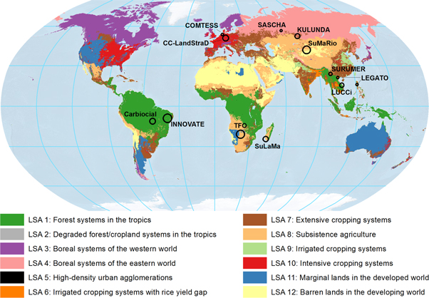
Figure 1. Geographical locations of investigated regional projects and their distribution in global land system archetypes defined by Václavík et al (2013) based on clustering of similar land-use intensity, environmental and socioeconomic conditions. The size of the project symbol is relative to the project's study area. The geographic locations of project study areas were obtained from the Geoportal of the SLM Program at: http://geoportal-glues.ufz.de/.
Download figure:
Standard image High-resolution image2.2. Data
We considered the same set of 32 indicators of land-use intensity, environmental conditions and socioeconomic situation as previously used to define global LSAs (see table A1 in the supplementary material). Details on the datasets and the indicator selection are provided in Václavík et al (2013). In summary, we compiled 15 land use datasets that measure different aspects of agricultural intensity in terms of inputs, outputs and system metrics (sensu Kuemmerle et al 2013). For input metrics, we chose maps of cropland and pasture cover (Klein Goldewijk et al 2011) and also calculated their changes over the last 50 years to account for temporal trends. In addition, we considered the extent of areas equipped for irrigation (Siebert et al 2007) and the levels of nitrogen (N) fertilizer input (Potter et al 2010). For output metrics, we included crop yields for wheat, maize and rice (Monfreda et al 2008), because these crops represent approximately 85% of global cereal production (Hafner 2003) and are grown in most of the considered regional projects. For system-level metrics, we selected yield gaps for wheat, maize and rice (IIASA/FAO 2012), the human appropriation of net primary production (HANPP; Haberl et al 2007), and soil erosion caused by water and tillage (Van Oost et al 2007).
To represent environmental conditions, we used five uncorrelated bioclimatic variables from the CliMond database (Kriticos et al 2012) accompanied by climate anomalies interpolated from NOAA's long-term measurements of land surface temperatures (Menne et al 2009). For biophysical factors that reflect productivity and growth conditions of ecosystems, we included datasets on normalized difference vegetation index (NDVI) (Tucker et al 2005) and soil organic carbon (Batjes 2006). Vertebrate species richness for mammals, birds, reptiles and amphibians were derived from expert-based range maps (BirdLife International 2012, IUCN 2012) as a biodiversity indicator reflecting both natural conditions and long-term effects of land management (Green et al 2005, Phalan et al 2014). For economic indicators of land systems, we used three indices provided by the Food and Agriculture Organization (FAO) at a national level: gross domestic product (GDP), the proportion of GDP resulting from agriculture and the capital stock in agriculture. As socioeconomic factors and indicators of human pressure on land, we used gridded data on population density (CIESIN 2005), the world governance index of political stability (Kaufmann et al 2010) and the global map of accessibility that measures travel time to major cities and market places (Uchida and Nelson 2009). We are aware that the geographical scope of the different parameters is not identical, and that taking data aggregated at national or regional scale can mask significant deviations in the research sites; one example is discussed below.
The requirement was that these datasets are available for the entire terrestrial surface of the world, so that transferability potentials can be investigated beyond the study areas of our case studies. The land-use data were derived for circa the year 2005, the time period where such datasets are richest at the global scale. Prior to the final variable selection, we inspected Pearson correlations between all variables in order to avoid redundancy in the input information (see table A2 in the supplementary material). Our final set of input indicators included only those with |r| < 0.7 (Dormann et al 2013). All data were aggregated to the spatial resolution of 5 arc-min (∼9.3 × 9.3 km at the equator).
2.3. Analysis of transferability potentials
We estimated transferability potentials for the twelve regional projects by calculating the statistical similarity of all 5 arc-min pixels across the world to the unique land system present in each project study area. We assumed that if the project study area overlaps with a specific LSA (Václavík et al 2013), then its research is potentially relevant for other geographical regions that belong to the same archetype. However, the original global classification, based on a self-organizing map clustering of the same variables as used here, is relatively coarse and thus high variability in land-use intensity and other conditions exists within the individual archetypes (Václavík et al 2013). Also, the availability, resolution and quality of underlying data vary across the world, suggesting that the precision of an archetype definition is not always comparable across regions. Therefore, we extended the original archetype framework and adopted a three-step approach to quantify the degree of similarity between given case studies and other regions around the world (figure 2).

Figure 2. Conceptual diagram of identifying and mapping potential transferability of place-based research. The upper rectangle represents a multidimensional space defined by land-use intensity, environmental and socio-economic indicators. The crosses denote the 'project archetypes', i.e. the mean conditions in the study areas of two hypothetical case studies; the circles denote the range of conditions present in the case study areas, with different shading representing similarity of conditions. The distance does not represent a geographical distance but a statistical measure of similarity of the considered variables. This distance can be mapped in a geographical space (lower rectangle), here showing the 'high' level of similarity (i.e. transferability potential) for each case study, with crosses denoting the location of the hypothetical study areas. Land systems similar to the project archetypes may differ in size or overlap both in the multi-dimensional and geographical space.
Download figure:
Standard image High-resolution imageFirst, we analyzed the conditions in each project as reflected by the considered variables and determined the 'project archetype', i.e. the unique land system in the study area. Prior to the analysis, we checked the data for skewed distributions and removed extreme outliers. Because of their differing units, we normalized all variables to zero mean and unit variance, so the results can be interpreted in terms of how much and in which direction the project conditions deviates from the global average. We defined the project archetype as the combination of the means Ai for all variables i = 1,..., 32 calculated as:

with x being the normalized value of each variable and p being the total number of cells in the regional project. Second, we calculated statistical similarity of the project archetype (represented by each grid cell within the project) to each global grid cell in the multi-dimensional space defined by considered variables, assuming higher transferability potentials in locations with similar land systems (figure 2). As a measure of similarity, we used an absolute distance D, calculated as:

with x being the normalized value of variable i, g being the number of global grid cells, p being the number of cells within a regional project and v being the number of considered variables. Third, using the inverse of distance D, we mapped the gradient of transferability potentials for each project in the geographical space (figure 2). For better visualization, we divided the gradient of transferability potentials into four equal classes, with the lowest 25% distance interval representing 'high' transferability potential and the highest 25% distance interval representing 'no' transferability potential.
We assumed that the variability in underlying conditions, which is likely to be higher for projects with larger study areas, may affect the total area estimated as having high transferability potential. Therefore, we used ordinary least square (OLS) regression analysis to examine the relationship between the total variability of conditions in the study area (calculated as the sum of standard deviations for all variables) and the extent of the 'high' transferability level. All analyzes were conducted in R version 3.2.0 (R Development Core Team 2011), using the libraries 'rgdal' (Keitt et al 2011) and 'vegan' (Oksanen et al 2013).
Finally, we chose one project, SASCHA (table 1, figure 1), for which we refined the analysis of transferability potentials with finer-scale data from its study area in Western Siberia. To illustrate the potential effects that differences in global versus local data may have on the final analysis, we replaced the values of six original variables (from datasets with a global extent) with those for the same variables from local datasets. Local datasets of cropland area (ha), pasture area (ha), N fertilizer use in agriculture (kg ha−1), wheat yield (t ha−1) and human population density were obtained from the Territorial Authority of the Federal State Statistics Service of the Tyumen Region (TyumStat 2015a, 2015b). The data were available at a district-level resolution for the entire province of Tyumen (160 000 km2), which has 22 districts with variable climate, socio-economic conditions, suitability for agriculture, cropland and pasture extent and land-use trends (Kühling et al 2016). The global GDP estimate for Russia was replaced by an official local estimate (the 'regional domestic product') for the Tyumen province (RosStat 2015).
3. Results
Each case study was characterized by a unique project archetype defined by a specific combination of land-use intensity, environmental and socioeconomic conditions (figure 3). The results identifying a gradient of transferability potentials for each of the twelve case studies are shown in figure 4. The mapped levels of transferability potentials varied regionally, often exhibiting spatial clustering of highly similar conditions around the project sites (e.g. for CC-LandStraD, COMTESS, LEGATO). In contrast, highly similar conditions were found for a number of projects in locations that are geographically distant from the study sites (e.g. for CarBioCial, KULUNDA, SASCHA). This corresponds with the original archetype classification which identified relatively large areas of similar land systems across the tropics and the boreal biome.
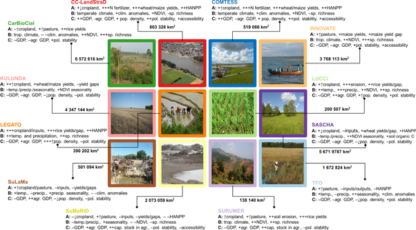
Figure 3. Project archetypes of the Sustainable Land Management Program. Summarized description of (A) land-use intensity indicators, (B) environmental conditions, (C) socioeconomic factors that characterize each project. The + and − signs show whether the factor is above or below global average (+ is up to 1 s.d., ++ is 1–2 s.d., +++ is >2 s.d.). The ↑ and ↓ signs signify increasing/decreasing trends within the last 50 years. The numbers in km2 show the total areas of regions identified as having a high level of transferability potential (the top 25% of the gradient).
Download figure:
Standard image High-resolution image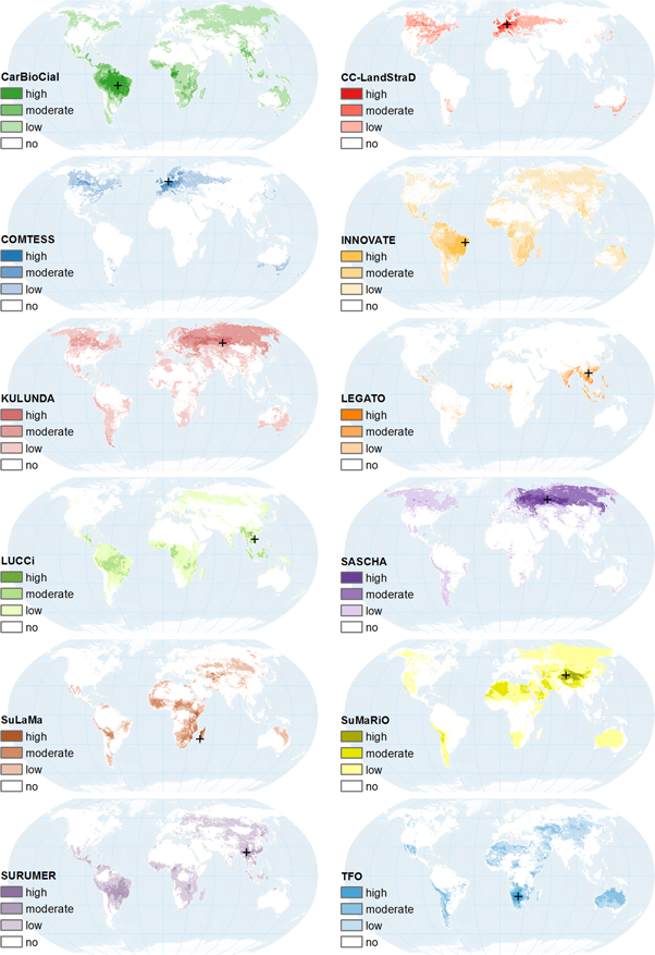
Figure 4. Mapped transferability potentials for the 12 regional projects based on all 32 variables. Areas with conditions similar to those in the regional projects are assumed to have higher transferability potentials. The gradient of transferability potentials is divided in four equal classes, ranging from high to no transferability potentials. For all RPs the same threshold is used, so the levels of transferability potentials and their spatial extents are comparable among the projects. The black cross in each map denotes the location (centroid) of each project's study area.
Download figure:
Standard image High-resolution imageThe top 25% of the calculated transferability potentials (the 'high' level in figure 4) contained areas with extents ranging from 138 140 km2 to 6572 616 km2 for SURUMER and CarBioCial, respectively (figure 3). A spatial overlay of these areas with high transferability potentials (top 25%) highlighted the parts of the world, for which the research of the SLM Program is most relevant (figure 5), but it also revealed areas that are likely under-represented by the SLM Program, e.g. in North America, Central Africa and the Middle East. In contrast, several regions were predicted as having high transferability potentials for more than one project. For example, large spatial overlaps of high transferability potentials exist for CC-LandStraD and COMTESS in Western Europe, for SASCHA and KULUNDA in Western Siberia and for CarBioCial and INNOVATE in central South America.
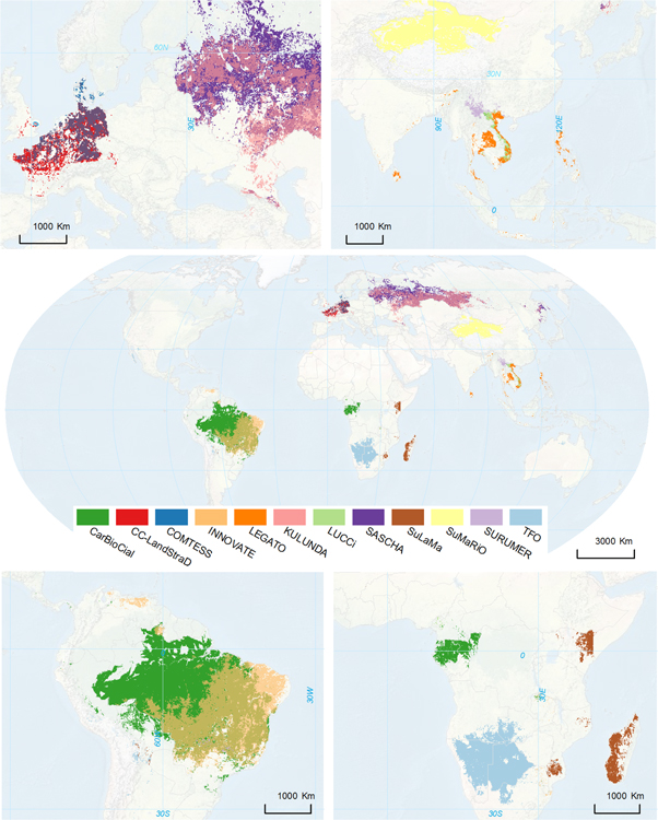
Figure 5. Areas with high transferability potential (top 25% of the transferability gradient), highlighting regions for which the research of the SLM Program is most relevant. The areas with no color, e.g. in North America, Central Africa and the Middle East, are under-represented in the Program's research efforts. In contrast, several regions are simultaneously covered by multiple projects. In the upper left inset, there is a large spatial overlap between CCLandStraD and COMTESS in central Europe (with COMTESS extending more to the coastal areas in the north), and between SASCHA and KULUNDA in Asia. In the lower left inset, there is an overlap in transferability potentials for CarBioCial and INNOVATE.
Download figure:
Standard image High-resolution imageThe differences and overlaps in project transferability potentials were also apparent when inspecting the combination of variable values that characterize each regional project (figure 6). For example, CC-LandStraD and COMTESS had similar values for most variables but differed slightly in cropland area and yields (see also figure A1 for non-standardized values in the original units). While several projects fell into the same global LSA (figure 1) defined by Václavík et al (2013), their project archetypes may still differ largely, suggesting a high regional diversity of conditions in the globally defined land systems. Even the conditions within the project study areas varied substantially for some case studies (figures 6 and A1). However, no significant relationship was found between the total variability of conditions in the study area and the extent of the 'high' transferability potential (OLS, R2 = 0.163, p = 0.194).

Figure 6. Detailed characterization of land systems in regional projects, showing the combination of normalized variable values. Zero on the x-axis is the global mean, so the graphs show whether and how much an indicator is above or below the global mean. The bars represent mean values of the conditions in each study area; the whiskers represent standard deviation (variability of the indicator) within the study area.
Download figure:
Standard image High-resolution imageThe refined analysis for SASCHA revealed similar patterns of transferability potentials across the Western Siberian grain belt compared to the analysis based on values of global datasets. However, the area estimated to have a 'high' transferability potential decreased to about 48% (2742 136 km2) of the area identified in the original analysis (figure 7). The global estimates of cropland area proportion closely matched the local statistics from the region (approx. 16% of cropland cover in both global and local datasets). However, the global values for realized wheat yield, GDP and population density were slightly lower than those collected from local sources. Larger differences between global and local data occurred for pasture area (difference of 12%) and N fertilizer (difference of 31 kg ha−1).

Figure 7. Transferability potential for the SASCHA regional project based on (a) global variables only and (b) refined with finer-scale datasets from the region. The chart on the right shows the combination of normalized variable values in the study area captured by the considered datasets. Variables for which local data were available are marked with red asterisks; their original values captured by the global datasets are displayed as light purple bars for comparison. The black cross in the maps denotes the project location.
Download figure:
Standard image High-resolution image4. Discussion
Our results show that there are areas beyond the projects' study sites that have similar land systems as those identified in the twelve regional projects of the SLM Program. While the degree of mapped transferability potentials was highly variable in different parts of the world, it was typically clustered around the project sites (figure 4). This pattern suggests that considered land-use intensity, environmental and socioeconomic conditions are spatially dependent (i.e. autocorrelated) and that calculated statistical distance partially corresponds to geographical distance. On the other hand, high transferability potentials for some case studies were found in regions that are relatively far from the project sites. This was typical for projects where variable values were close to the global mean or where the project archetype was driven by large-scale environmental or socioeconomic conditions. For example, areas with high transferability potentials for KULUNDA and SASCHA were identified across the entire Eurasian steppe belt. This is likely due to the similar biophysical conditions (climate, soils) along the latitudinal ecozones of Eurasia (Degefie et al 2014, Kamp et al 2015). Similarly, the socioeconomic conditions are rather comparable across Russia due to a strongly centralized political and economic system.
The spatial overlay of the high transferability potentials for all projects (figure 5) highlighted not only regions for which research of the SLM Program is most relevant but revealed also 'white spots' that constitute archetypes of low transferability potentials due to relatively large differences among the projects in the underlying land system conditions. This shows that even when a project falls within a certain LSA, its transferability potential does not necessarily extend across the entire range of this land system because the globally defined LSAs still host a high diversity of conditions. This also confirms our assumption that the original archetype framework needed to be refined to allow a reasonable analysis of transferability potentials of regional case studies. However, we did not confirm our assumption that the level of variability in considered conditions within the project's study area affects the total area estimated as high transferability potential. The non-significant relationship between the two factors can be caused by the complexity of considered land system indicators, the spatial distribution of their values across the world, the selection of the threshold used to define the 'high' transferability potential level (i.e. the top 25% of the distance gradient), but also by the relatively small sample size (n = 12).
In contrast, we found several regions with spatial overlap of high transferability areas for multiple projects. The similarity in project archetypes of these case studies can be in large part attributed to the close proximity of their study sites. For example, the relative closeness of CC-LandStraD and COMTESS, both with study sites in northern and western Germany, resulted in 62% overlap of their areas with high transferability potential. Nevertheless, even at this scale and based on global datasets of land system indicators, our analysis was able to detect relatively small local differences between the project characteristics. CC-LandStraD that has the aim to analyze contributions of land management in Germany to climate mitigation has its study sites chosen to represent land systems of a developed high-tech country in a temperate climate zone and reliable political structures (Fick et al 2014). Indeed, this is reflected in the results that identified areas with high potential for transferability in large parts of Western Europe, especially Germany and France but also parts of Central Europe. In contrast, COMTESS that focuses on developing land use strategies to promote sustainable management of vulnerable coastal landscapes (Karrasch et al 2014) has its high transferability potentials situated more to the north. In addition to covering large portions of Germany and France, the estimated areas with high transferability potential extend to coastal areas of Belgium, the Netherlands and Denmark.
The refined analysis of transferability potentials for SASCHA revealed a dependency of the results on the resolution and accuracy of the considered input data (figure 7). Surprisingly, the global datasets captured the regional realities (represented by data from regional statistics) considerably well, although the indicators of pasture areas and N fertilizer were underestimated in the global datasets. This led to an overall decrease of the estimated transferability potentials in the refined analysis (e.g. lower transferability potentials in Ukraine due to differences in yields and socioeconomic conditions), but the general pattern remained largely similar, covering most of the Western Siberian grain belt (Kühling et al 2016). Similarly for SURUMER, which focuses on sustainable rubber cultivation in the Mekong Region, only few out of the 32 global variables had values that did not closely match the local reality (Hauser et al 2015). Of the land-use intensity indicators, both cropland area and the use of N fertilizer were underestimated. Recent data published by Xu et al (2014) point towards a total share of 22% of rubber, paddy rice and upland maize cultivation in the SURUMER wider research area, as opposed to about 10% of cropland area indicated in the global dataset. Also, the maize yields appear to be underestimated considering the availability of industrial fertilizer and presence of an agricultural extension system in China (Hu et al 2009). The FAO data for China (FAOSTAT 2010) indicate maize yields of 5.2 t ha−1, as opposed to less than 2 t ha−1 given by the global dataset. Soil organic carbon content may be also underestimated as the vast majority of rubber plantations are situated on soils cleared recently from forest (Hauser et al 2015).
We used a comprehensive set of global land system metrics with the highest resolution currently available. However, despite considerable improvements in global-scale geospatial datasets (Verburg et al 2011), the main sources of uncertainty remain in the quality of input data and the availability of socio-cultural information in a globally standardized format. The quality of datasets is affected by many factors, such as the reliability of ground-based inventories, processing techniques of remotely sensed records, positional accuracy, spatial scale of data aggregation or the difficulties in quantification and standardization (Kuemmerle et al 2013). Some land use indicators (e.g. yield gaps, N fertilization) are also based on hybrid maps that link remote sensing or ground-based measurements with outputs of mechanistic models, therefore errors in the base data can propagate onto derivative maps (Verburg et al 2011). This also explains why many available land use indicators tend to be correlated, although in our analysis we included only those with limited redundancy (table A2). Although we embraced a wide range of variables on land-use intensity as well as environmental and socioeconomic conditions, numerous gaps exist in the availability of important land system indicators. For instance, information on mechanization, farm size, pesticide use, labor intensity, shifting cultivation or forest logging is lacking or is unavailable in adequate quality for many regions. Furthermore, information on culture, governance and policies are notoriously difficult to capture in spatially explicit datasets (Otto et al 2015).
On the other hand, our approach is not limited to the selected sets of indicators but allows including any data that are appropriate for a given case study and research question. For example, we included yields for three major crops as output metrics of land-use intensity because together they are representative for the majority of global cereal production. However, data for many other crops are now available. For instance, oil palm and soybean plantations are of major concern for conservation due to their expansion in the tropics (Gasparri et al 2013, Wilcove et al 2013); they can be used in the analysis in addition to or instead of the current three crops. Our approach also allows giving preference to specific variables or sets of variables. Figure 8 provides an example of the transferability potential analysis for LEGATO calculated separately for land-use intensity, environmental and socioeconomic conditions. For instance, when the environmental conditions are considered to be the sole criteria for defining transferability potentials, the results identify large portion of Southeast Asia as having similar land systems determined by broad-scale gradients of climate, soil and natural productivity of ecosystems (figure 8(b)). When land-use intensity is selected as the main criterion, the areas with high transferability potentials are restricted to a scattered pattern of intensive irrigated cropping systems in the Philippines, Vietnam, Thailand and Indonesia (figure 8(a)). The combination of all sets of variables then leads to the final pattern determined by the overall similarity of land systems to the project archetype (figures 4 and 5).

Figure 8. Transferability potential for the LEGATO regional project based on (a) land-use intensity indicators, (b) environmental indicators, and (c) socioeconomic indicators. The black crosses denote locations of the project's seven study landscapes in the Philippines and Vietnam.
Download figure:
Standard image High-resolution image
Transferability, however, is a complex issue and testing which specific results or land management recommendations may be transferable into which regions, and how they can be implemented, requires a separate comprehensive analysis for each case study, based on project-specific hypotheses and fine-scale methods and data. For example, LEGATO investigates how to advance long-term sustainable development of irrigated rice agro-ecosystems, quantifying a range of ecosystem services, from provisioning services of rice production, through regulating services of pollination and biocontrol, to cultural services of identity and sense of place (Settele et al 2015). Different sets of criteria would have to be considered to test transferability of findings for different ecosystem services. The transfer of results regarding rice production requires accounting not only for the land-use metrics considered in this study but also for soil characteristics (e.g. concentration of silicon), dynamics of soil biota, varieties of rice planted or co-production of other goods in the rice paddies, such as fish and molluscs (Klotzbücher et al 2015, Schmidt et al 2015). The transfer of results regarding biological control of pests depends on the functional similarity of local food webs (species compositions, population densities, growth rates) that occur in landscapes with comparable habitat heterogeneity and is restricted to areas where the costs of pesticide application are high enough for farmers to be motivated to search for methods using biocontrol, or where governments intervene to enforce principles of ecological engineering (Spangenberg et al 2015). The results regarding cultural services cannot be easily transferred outside of the cultural context defined by the semiotic system of local communities, including religious views, belief systems, traditions and rituals (Spangenberg et al 2014). These complex issues illustrate that rather than offering a way to test local-scale transferability of specific findings per se, our approach provides a starting point to identify broad-scale regions with potential transferability of place-based research by calculating envelopes that define the general boundaries of projects' relevance outside of their study areas.
5. Conclusions
Place-based research in local and regional case studies has been central to understanding land use as a result of dynamic interactions within SESs that operate across spatial and temporal scales (Rounsevell et al 2012). Any generalization of place-based research is challenging because results depend on host of factors unique to the study system. Needed are ways of extracting general insights from the idiosyncrasies of place, so they can be applied to previously unstudied systems (van Vliet et al 2015). In this paper, we addressed this challenge by assessing the geographical relevance of case studies and investigated their potential transferability beyond the geographical context in which they are conducted. We adapted the previously developed concept of LSAs because land systems serve as an efficient platform for integrating different perspectives and dimensions of land use research (Verburg et al 2015). Our analysis of transferability potentials contributes to the development of globally relevant knowledge creation and sharing in land system science, and advances the discussion on how applicable the most up-to-date global datasets are for characterizing regional-scale findings. The proposed method can serve as a blueprint for large-scale research programs to assess potential transferability of place-based studies to other geographical areas and to indicate possible gaps in research efforts. Such assessments will be ultimately helpful to better understand and enhance the transparency of the biophysical and socioeconomic background on which decision-makers develop and evaluate SLM strategies.
Acknowledgments
This project was supported by the German Federal Ministry of Education and Research (BMBF) through the funding program: Sustainable Land Management. TV and RS were funded by BMBF grant 01LL0901A: GLUES. FL, SH, JS and JHS were funded by BMBF grant 01LL0917A-01LL0917O: LEGATO. MC and IH were funded by BMBF grant 01LL0919: SURUMER. JF was funded by BMBF grant 01LL0909A-F: CC-LandStraD. JK was funded by BMBF grant 01LL0906A: SASCHA. This research contributes to the Global Land Project (www.globallandproject.org).