

Abstract
Low-lying reef islands in the Solomon Islands provide a valuable window into the future impacts of global sea-level rise. Sea-level rise has been predicted to cause widespread erosion and inundation of low-lying atolls in the central Pacific. However, the limited research on reef islands in the western Pacific indicates the majority of shoreline changes and inundation to date result from extreme events, seawalls and inappropriate development rather than sea-level rise alone. Here, we present the first analysis of coastal dynamics from a sea-level rise hotspot in the Solomon Islands. Using time series aerial and satellite imagery from 1947 to 2014 of 33 islands, along with historical insight from local knowledge, we have identified five vegetated reef islands that have vanished over this time period and a further six islands experiencing severe shoreline recession. Shoreline recession at two sites has destroyed villages that have existed since at least 1935, leading to community relocations. Rates of shoreline recession are substantially higher in areas exposed to high wave energy, indicating a synergistic interaction between sea-level rise and waves. Understanding these local factors that increase the susceptibility of islands to coastal erosion is critical to guide adaptation responses for these remote Pacific communities.
Export citation and abstract BibTeX RIS

Original content from this work may be used under the terms of the Creative Commons Attribution 3.0 licence. Any further distribution of this work must maintain attribution to the author(s) and the title of the work, journal citation and DOI.
Introduction
How islands and the communities that inhabit them respond to climate change and particularly sea-level rise is a critical issue for the coming century. Small remote islands are viewed as particularly vulnerable (Wong et al 2014). The islands of the Pacific with the small populations that subsist on them provide valuable insight into the geomorphic, ecological and social impacts of sea-level rise. How these Pacific islands and their inhabitants respond and adapt to sea-level rise will provide critical lessons to guide future responses to the significant sea-level rise anticipated in the coming century (Barnett and Adger 2003).
Due to their extreme vulnerability, coral atolls have been the main focus for assessing island responses to sea-level change. Whilst shoreline recession has been documented on atolls over past decades, the majority of studies have not specifically demonstrated evidence linking shoreline recession to recent sea-level rise (Webb and Kench 2010, Le Cozannet et al 2014). The limited research that has been conducted to date on the responses of reef islands in the western Pacific indicates that islands are highly dynamic, with coastal erosion and inundation threatening infrastructure, resulting generally from extreme events, human armouring of shorelines (e.g. seawalls) or inappropriate planning and development rather than sea-level rise alone (Bayliss-Smith 1988, Merrifield and Maltrud 2011, Ford 2012, Biribo and Woodroffe 2013, Hoeke et al 2013, Mann and Westphal 2014). The volcanic islands of Melanesia are typically considered to be less vulnerable to sea-level rise due to high elevations and low population densities (Barnett and Adger 2003, Nunn et al 2014).
The Solomon Islands in the Western Pacific comprise over 1000 predominantly volcanic islands, many reaching over 500 m elevation. The human population of 560 000 is spread across 28 000 km2 making it amongst the most sparsely populated of Pacific Island nations. Despite this low population density, the majority of human settlements are located in low-lying coastal areas, and reef islands are becoming increasingly densely populated due to restricted flat land adjacent to the coast. Rates of sea-level rise in the Solomon Islands over the past two decades are amongst the highest globally, averaging 3 mm yr−1 since 1950 and 7–10 mm yr−1 since 1994 (Becker et al 2012).
Anecdotal accounts exist of extreme shoreline changes over the past decade from scientists and local inhabitants across all provinces of the Solomon Islands. Understanding the extent and rate of recent shoreline changes on the islands of the western Pacific is an important step towards assisting these vulnerable communities to adapt to the unprecedented rate of sea-level rise and associated climate changes (e.g. winds and waves) expected over the coming century.
Methods
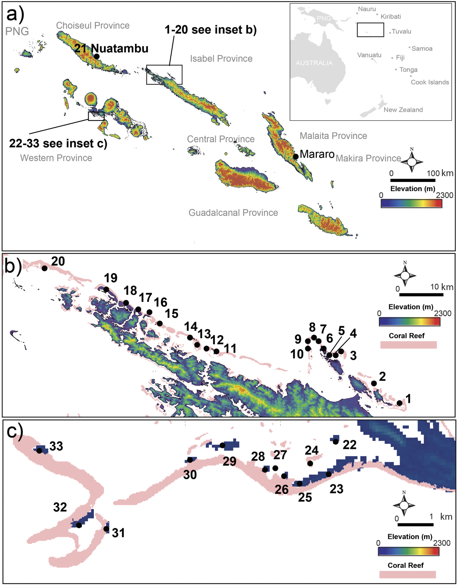
This study focussed on two areas of the Solomon Islands with the highest density of exposed reef islands, Isabel and Roviana. We surveyed twenty reef islands on the barrier reefs along the north-west coast of Isabel, twelve reef islands on the barrier reef of Roviana Lagoon and Nuatambu and Mararo communities on the adjacent volcanic islands of Choiseul and Malaita respectively (figure 1). Only two of the sites (Nuatambu and Mararo) are populated, whilst the sites in Isabel and Roviana have no known history of continuous human habitation. The islands in Roviana are used on a daily basis by nearby communities for fishing, whilst the islands in Isabel are infrequently visited on a weekly-monthly basis by fishers with no significant disturbance of coastal vegetation by fishers observed.

Figure 1. Map of study sites. (a) Map of the Solomon Islands relative to south Pacific region indicating study sites (•) in Choiseul (Nuatambu), Malaita (Mararo) and Isabel Provinces, (b) inset of study sites across northern Isabel. Sites from east to west: 1. Rehana, 2. Zollies, 3. Sogomou, 4. Sogomou ite, 5. Sogomou Fa, 6. Kumarara, 7. Sasahura Fa, 8. Sasahura ite, 9. Golora, 10. Retu, 11. Hetaheta, 12. Kakatina, 13. Rapita, 14. Kukudaka, 15. Kale, 16. Korapagho, 17. Kologhose, 18. Ghebira, 19. Bates, 20. Suki, (c) inset of study sites in Roviana. Sites from east to west: 22. Piraka, 23. Nusa Ghele, 24. Pukuni, 25. Ovio, 26. Varilangge, 27. Ighisi, 28. Panao, 29. Homhombu, 30. Hopei, 31. Kunkundu Hite, 32. Kunkundu Nomana, 33. Nusa Lavata.
Download figure:
Standard image High-resolution imageHistorical aerial photographs from 1947 to 1962 were sourced from the Solomon Islands Government Ministry of Housing, Lands and Survey archives. In addition, high resolution satellite imagery was sourced for each site for 2002 (Ikonos 0.8 m resolution), 2011 (Nuatambu-Quickbird 0.6 m, other sites-Worldview-2 0.5 m resolution) and 2014 (Worldview-2 0.5 m resolution). Historical photos were georeferenced against stable features in the most recent high resolution satellite image for each site. The vegetation edge of each island for each historical image was digitised and used as a long-term shoreline change proxy (Liu et al 2014) (see supplementary table 1 for uncertainty assessments). Reef island dynamics were also tracked using mass centre analysis (Paris and Mitasova 2014) to determine the centroid of each island over time. Historical sea-level data and projections for the 21st century for the Solomon Islands are available from a recent assessment of climate change in the Pacific (Australian Bureau of Meteorology and CSIRO 2014). These regional projections used similar methodology (documented in McInnes et al 2015) to the Intergovernmental Panel on Climate Change Fifth Assessment Report (Church et al 2013). Ages of trees (Casuarina equisetifolia and Sonneratia alba) from three islands were estimated using bomb-pulse radiocarbon techniques to date the heartwood and better understand the historic context of shorelines (see supplementary table 3).
Wind and wave hindcast data
Estimates of wave energy flux (W m−1) for the period 1980 to 2009 at two locations (1. Roviana: latitude −8.39979, longitude 157.26700; and 2. Isabel: latitude −7.33312, longitude 159.00030) were sourced from the CAWCR Wave Hindcast 1979–2010 data (Source: Australian Bureau of Meteorology and CSIRO as described by Durrant et al 2013). These locations provide an indication of the wave climate at the Roviana and Isabel study sites during this period. Data for these locations were extracted from the nested grid (4 arcmin ∼7 km) for the Australian region. Data for the 1979 calendar year was discarded to ensure artefacts associated with the spin-up and initial conditions of the underlying model were avoided. Directional wave energy flux data for each site were arithmetically averaged over three different 10 yr periods (1980–1989, 1990–1999, 2000–2009) to investigate decadal changes in the average magnitude and direction over this 30 yr timeframe. Average wave energy vectors (aligning with the direction of wave travel) were plotted for each site with 0° representing wave travel to the north (true north) direction and 90° representing wave travel to the east direction.
Results
Five of the twenty vegetated reef islands along the barrier reef on the exposed, northern coast of Isabel have been totally eroded away in recent decades (supplementary table 2), leaving no supratidal substrate and dead tree trunks resting on hard reef platform. A further six islands on Isabel had declined in area by more than 20% between 1947 and 2014. Hetaheta, Sogomou and Kale experienced the largest loss of island area between 1947 and 2014, declining in size by 155 790 m2 (62%), 110, 930 m2 (55%) and 48 890 m2 (100%) respectively (table 1 and figure 2). Change in the twelve islands in Roviana was mixed with six islands growing slightly (<20%) and six islands declining slightly (<20%).
Table 1. Island area and loss over time. Area (edge of vegetation) of islands with greater than 20% change from 1947 to 2014 based on aerial and satellite imagery.
| Island area (m2) | |||||||
|---|---|---|---|---|---|---|---|
| Site | 1947 | 1962 | 2002 | 2011 | 2014 | Area lost since 1947 (m2) | Overall loss (%) |
| Kale | 48 890 | 43 070 | 12 572 | 509 | 0 | 48 890 | 100 |
| Rapita | 45 700 | 21 250 | 0 | 0 | 0 | 45 700 | 100 |
| Rehana | 38 330 | 21 800 | 0 | 0 | 0 | 38 330 | 100 |
| Kakatina | 15 150 | 3580 | nd | 0 | 0 | 15 150 | 100 |
| Zollies | 12 240 | 4980 | 0 | 0 | 0 | 12 240 | 100 |
| Hetaheta | 251 700 | 239 380 | nd | 104 300 | 95 910 | 155 790 | 62 |
| Sogomou | 203 250 | 199 670 | 120 070 | 98 210 | 92 320 | 110 930 | 55 |
| Nuatambu* | 28 660 | 30 080 | nd | 20 520 | 13 980 | 14 680 | 51 |
| Sogomou Ite | 139 660 | 132 950 | 115 970 | nd | 107 300 | 32 360 | 23 |
| Sasahura Ite | 47 040 | 48 320 | 40 010 | 36 670 | 36 130 | 10 910 | 23 |
| Sasahura Fa | 162 770 | 174 780 | 152 960 | 135 860 | 130 040 | 32 730 | 20 |
Note: *Partial Island—only village area assessed, nd = no data.

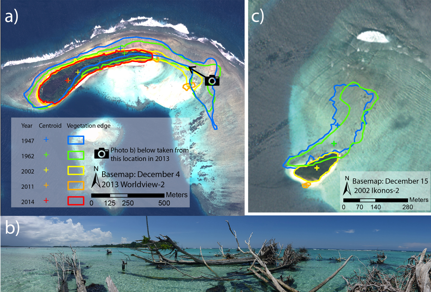
Figure 2. Coastal recession of Sogomou and Kale. (a) Coastline recession on Sogomou Island between 1947 and 2014, (b) view from the eroding eastern end of Sogomou looking back towards the remainder of the island, (c) coastline recession on Kale Island between 1947 and 2014. Note: Kale Island was completely displaced by 2014.
Download figure:
Standard image High-resolution imageThe rate of loss of seven islands on Isabel, for which time series imagery exists (1947, 1962, 2002 and 2014), increased from a mean of 0.1% pa between 1947 and 1962, 0.5% pa between 1962 and 2002 to 1.9% pa between 2002 and 2014 (figure 3). Islands in Roviana did not experience a change in the rate of loss over the study period, with island loss rates averaging 0.1% pa, −0.2% pa and 0.1% pa across the three time periods.

Figure 3. Annual rate of areal change for seven islands in Isabel (red boxes) and five islands in Roviana (green boxes) for periods 1947–1962, 1962–2002 and 2002–2014.
Download figure:
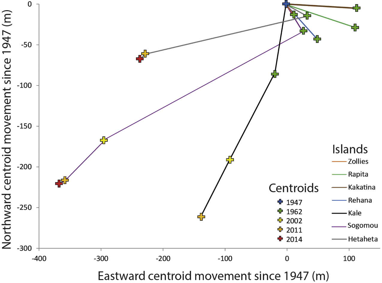
Standard image High-resolution imageThe centroid of the seven islands on the northern coast of Isabel with >50% loss moved in a south, south-east or easterly direction between 1947 and 1962. The centroid of Kale on Isabel was displaced 293 m on a bearing of 207° between 1947 and 2011 before the remaining sediment was transported off the reef platform into deep water. Likewise, the centroid of Sogomou was displaced 550 m along a bearing of 224° and the centroid of Hetaheta was displaced 244 m along a bearing of 255° over the same time period. The centroid of these three islands initially moved in a south-southeast direction between 1947 and 1962 before moving rapidly in a west-southwesterly direction between 1962 and 2014 (figure 4). The islands of Zollies, Rehana, Kakatina and Rapita all disappeared between 1962 and 2002 (table 1). Severe coastal recession on the eastern shoreline of Nuatambu village occurred between 2011 and 2014 resulting in ten houses being lost to the sea (supplementary figure 2).

Figure 4. Movement of the centroid of seven islands on the north-west coast of Isabel between 1947 and 2014.
Download figure:
Standard image High-resolution imageWave energy flux in Roviana was relatively low with a generally north-westerly wave climate of 0.22, 0.28 and 0.18 W m−1 in 1980–1989, 1990–1999 and 2000–2009 respectively. Wave energy flux at Isabel was twenty-fold higher than Roviana with a generally south-westerly wave climate of 4.9, 4.4 and 4.2 W m−1 in 1980–1989, 1990–1999 and 2000–2009 respectively (figure 5).
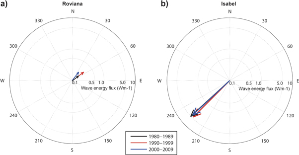
Figure 5. Average daily swell wave energy vectors offshore from (a) Roviana and (b) Isabel in 1980–89 (black arrow), 1990–99 (red arrow) and 2000–09 (blue arrow).
Download figure:
Standard image High-resolution imageDiscussion
At least eleven islands across the northern Solomon Islands have either totally disappeared over recent decades or are currently experiencing severe erosion. However, islands in the more sheltered Roviana area of the southern Solomon Islands did not experience significant coastal recession. Understanding the drivers of this rapid shoreline recession and contrasting erosion rates between different areas within this region is critical to provide a foundation for local adaptation strategies. Climate change induced sea-level rise is anticipated to be one of the greatest challenges for humanity over the coming century. Whilst it has been shown that sediment accretion may help atoll reef islands adapt to higher sea levels over recent decades (Kench et al 2015), it is likely current rates of sea-level rise will be exceeded during this century (figure 6). To date, the responses of the islands of Melanesia to sea-level rise have been poorly studied, a recent review of island change studies in the Pacific indicated 'little evidence of heightened erosion or reduction in island size' (McLean and Kench 2015). These islands were located across the Central Pacific in areas with 1–5 mm yr−1 sea-level rise where net accretion occurred on most islands and only small (<1 ha) islands were actively eroding (McLean and Kench 2015). Several documented cases of island accretion can be attributed to anthropogenic influences such as reclamation (Biribo and Woodroffe 2013). In contrast, the majority of uninhabited islands from the northern Solomon Islands were actively eroding across all size classes, including those over 25 ha in size (figure 7). Large Casuarina equisetifolia and Sonneratia alba trees (>40 cm dbh) were present on the shoreline of all of the actively eroding islands and dating of selected trees indicated shoreline stability over the past 150–250 yr until the recent erosion documented here (supplementary table 3).

Figure 6. Sea level in the Solomon Islands between 1950 and 2100. Sea level in the Solomon Islands from reconstruction (following the approach of Church et al 2004 and Church and White 2011), satellite altimeter (Church and White 2011), tide gauge and projections of 21st century sea level rise for the four emission scenarios used in the IPCC AR5. The dashed lines are an estimate of interannual variability in sea level (5%–95% uncertainty range about the projections) and indicate that individual monthly averages of sea level can be above or below longer-term averages.
Download figure:
Standard image High-resolution image
Figure 7. Island change in the Central Pacific and Solomon Islands. Summary data of island area and percentage decadal change at seven atoll sites in the Central Pacific (modified from McLean and Kench 2015) and Solomon Islands (this study). Island-change data within the highlighted ±3.0% band width is not considered significant.
Download figure:
Standard image High-resolution image
El Niño/Southern Oscillation events result in significant interannual variations in sea level in the western equatorial Pacific (Barnard et al 2015) (including the Solomon Islands, figure 6) superimposed on the longer term (multi-decadal) sea-level trends of up to 3 mm yr−1 (Church et al 2006, Becker et al 2012). Merrifield et al (2012) used tide gauge data to demonstrate that the rate of western equatorial Pacific sea-level rise increased significantly from relatively low values over the 1950–1990 period to much larger values since 1990. While there is significant interannual variability, the tide gauge and altimeter data indicate a rapid rise in sea levels in the Solomon Islands between 1994 and 2014 of about 15 cm (average of 7 mm yr−1). Projected sea-levels for the Solomon Islands indicate a rise of 24–89 cm between 1996 and 2090, dependent on future greenhouse gas emissions (Australian Bureau of Meteorology and CSIRO 2014) (figure 6). The higher local rate of historical rise is the result of both a larger global averaged rate of sea-level rise (Church and White 2011) and also stronger trade winds since 1990 (Merrifield and Maltrud 2011) which are directly related to the decreasing Pacific Decadal Oscillation index (Zhang and Church 2012). These PDO and ENSO conditions may ease in the Solomon Islands in coming decades to produce sea-level rise rates closer to the global average. However, as eustatic rates of sea-level rise increase over the course of this century we can expect that many areas will experience sea-level rise rates similar to or larger than the 7 mm yr−1 recently observed in the Solomon Islands for all but the very lowest emission scenarios. Local inter-decadal variability and tectonic movements will be superimposed on these higher rates of global mean sea level, resulting in periods when local rates of rise will be substantially larger than that observed over the last two decades. Therefore, we see the current conditions in the Solomon Islands as providing insight into the future impacts of accelerated sea-level rise.
Relative sea-level rise can also be the result of tectonics, the Solomon Islands are in a particularly tectonically active part of the globe with the convergence of the Pacific Plate, Solomon Arc block and Australian Plate causing localised crustal deformations (Tregoning et al 1998) manifesting as either island subsidence or uplift (Taylor et al 2008). Whilst the Isabel study site is considered to be in a more tectonically benign area, without active volcanoes, the Roviana site experienced an 8.1 megathrust earthquake in 2007 which led to the reef islands of Roviana subsiding by up to 60 cm (Taylor et al 2008). Island subsidence can compound sea-level rise rates and make these tectonically active islands particularly vulnerable under accelerated sea-level rise scenarios. However, the apparent resilience of islands in Roviana to subsidence, despite observed increases in coral cover on adjacent reefs attributed to deeper water (Saunders et al 2015), and only 1 (±1.4) mm yr−1 of vertical tectonic uplift measured in Honiara since 2008 (Jia et al 2015), suggests subsidence is not the primary driver of coastal erosion observed in this study.
The rapidly eroding islands identified in Choiseul and Isabel are all exposed to northerly swell and wind events that at times can be severe (Smithers and Hoeke 2014), with twenty-fold higher wave energy at Isabel compared to Roviana (figure 5). The largest net erosion since 1947 occurred on Sogomou, Hetaheta and Kale Islands on Isabel, causing erosive displacement in a south-south-westerly direction. Centroid shifting of these islands in a consistent direction (opposite to dominant wave direction) suggests erosion is not solely a result of sea-level rise (figures 4 and 5). Wave energy can interact synergistically with localised sea-level rise (through changing wave refraction dynamics and more wave energy propagating across reef crest onto the coast) to exacerbate coastal erosion (Storlazzi et al 2015) and thus may be a key driver of the rapid coastal recession in the Solomon Islands. Further work is required to determine the relative importance of extreme wave events or incremental changes in incident wave energy and their interactions with sea-level on shoreline dynamics of islands.
Coastal erosion in the Solomon Islands over recent decades is causing unprecedented threats to the biota on these fragile islands and the subsistence communities who inhabit them. The isolation from predators that these offshore islands provide makes them critical nesting habitats for many endangered sea turtles and birds. The south Pacific's largest rookery of Hawksbill turtles on the nearby Arnavon islands has been threatened in recent years due to substantial beach recession (Poloczanska et al 2009). In addition to ecological impacts, over the past two decades, many coastal communities have become increasingly vulnerable to receding shorelines and inundation from extreme water levels (Hoeke et al 2013). Inundation severity and frequency has become unacceptable for several communities and relocation has occurred on an ad hoc basis. In Nuatambu village on northern Choiseul over 50% of houses have been washed into the ocean as a result of dramatic shoreline recession. Residents of Nuatambu described the shoreline recession as incremental over several years, rather than related to a specific storm or wave event as experienced elsewhere in the region (Hoeke et al 2013). Many families have relocated to the adjacent high volcanic island of Choiseul; however some economically disadvantaged families have re-built temporary housing in increasingly vulnerable areas of Nuatambu. The relocation to the adjacent high island has not been conducted in a systematic way to ensure this small insular community remains intact; instead families have moved to areas of land they have customary tenure claims over. In the case of Nuatambu, families have spread out over five separate areas in small hamlets. In Mararo village on eastern Malaita relocation as a result of coastal erosion has been more orderly with the entire community making the decision to relocate from the coast to a high elevation site 20 m above sea level. Interestingly in this case the community had historically lived in a high elevation site prior to being encouraged by missionaries down to the coast in the early 20th century. In addition to these village relocations, Taro, the capital of Choiseul Province is set to become the first provincial capital globally to relocate residents and services due to the threat of sea-level rise.
Conclusion
This study represents the first assessment of shoreline change from the Solomon Islands, a global sea-level rise hotspot. We have documented five vegetated reef islands (1–5 ha in size) that have recently vanished and a further six islands experiencing severe shoreline recession. Shoreline recession at two sites has destroyed villages that have existed since at least 1935, leading to community relocations. The large range of erosion severity on the islands in this study highlights the critical need to understand the complex interplay between the projected accelerating sea-level rise, other changes in global climate such as winds and waves, and local tectonics, to guide future adaptation planning and minimise social impacts.
Acknowledgments
The support of the Solomon Islands Government and communities of Mararo and Nuatambu is greatly appreciated. We also acknowledge the satellite imagery support received from DigitalGlobe Foundation, logistical support from The Nature Conservancy and local knowledge from Corey Howell, Patrick Pikacha and David Boseto. We thank Gerard Heuvelink for help with analysis of uncertainty propagation.
Author contributions
SA conceived, designed and conducted the study and co-wrote the manuscript, JL and AG designed and conducted the study and contributed to manuscript, BG, CW and JC sourced and analysed data and contributed to the manuscript.