

Abstract
Proximity to the coast and elevation are important geographical considerations for human settlement. Little is known, however, about how spatial variation in these factors exactly relates to human settlements and activities, and how this has developed over time. Such knowledge is important for identifying vulnerable regions that are at risk from phenomena such as food shortages and water stress. Human activities are a key driving force in global change, and thus detailed information on population distribution is an important input to any research framework on global change. In this paper we assess the global geospatial patterns of the distribution of human population and related factors, with regard to the altitude above sea level and proximity to the coast. The investigated factors are physical conditions, urbanisation, agricultural practices, economy, and environmental stress. An important novel element in this study, is that we included the temporal evolution in various factors related to human settlements and agricultural practices over the 20th century, and used projections for some of these factors up to the year 2050. We found population pressure in the proximity of the coast to be somewhat greater than was found in other studies. Yet, the distribution of population, urbanisation and wealth are evolving to become more evenly spread across the globe than they were in the past. Therefore, the commonly believed tendency of accumulation of people and wealth along coasts is not supported by our results. At the same time, food production is becoming increasingly decoupled from the trends in population density. Croplands are spreading from highly populated coastal zones towards inland zones. Our results thus indicate that even though people and wealth continue to accumulate in proximity to the coast, population densities and economic productivity are becoming less diverse in relation to elevation and distance from the coast.
Export citation and abstract BibTeX RIS

Original content from this work may be used under the terms of the Creative Commons Attribution 3.0 licence. Any further distribution of this work must maintain attribution to the author(s) and the title of the work, journal citation and DOI.
1. Introduction
Human population is unevenly distributed across the globe. The process causing this uneven distribution is a complex interplay of several different factors (McGaugh 1970). Proximity to the coast has been attractive to people and businesses over the course of human history. Today, millions of people rely on proximity to the coast for their livelihoods (Brown et al 2014). One reason for this attractiveness includes the provision of favourable opportunities for livelihoods, economic activities, and trade. Another factor that is important in terms of the distribution of human settlements is elevation, as high elevations often relate to high relief, and elevation has a profound impact on climatic conditions.
Several studies have attempted to understand the influence of either proximity to coast or elevation on population distribution, initially motivated by general geographic interest (Kossinna 1921, Harrison et al 1983). More recently, such studies have also been motivated by the influence of various natural and human hazards and concerns on population distribution (Hinrichsen 1990, 1994, 1996, Elvidge et al 1997, Cohen and Small 1998a, 1998b, Hinrichsen 1999, Vorosmarty et al 2000, Huddleston et al 2003, Small and Nicholls 2003, Small 2004, McGranahan et al 2007, Parry 2007, Harvey and Nicholls 2008, Torresan et al 2008, Dasgupta et al 2009, Lichter et al 2011).
The classic work of Kossinna (1921) related earth's surface area to elevation. He divided the globe's earth mass by 1 km height intervals. It was not until the work by Harrison et al (1983) that this vertical resolution was refined, up to 100 m. Hinrichsen (1990, 1994, 1996) estimated the coastal population as well as related environmental factors in a series of studies, and has been widely quoted since, although the methodology used is not thoroughly documented (Cohen et al 1997). The advent of Geographic Information Systems in the 1990s allowed gridded analyses with a far higher resolution (Cohen et al 1997). Cohen and Small (1998a) analysed human population density in relation to the Earth's hypsography (earth's surface area vis-à-vis elevation). This was carried out by linking global gridded elevation data with a gridded population dataset. These studies found that the coastal zone (defined as areas with elevation less than 100 m and closer than 100 km to the coast) housed around one quarter of the global population in 1990 (Cohen and Small 1998a, 1998b, Small and Nicholls 2003), and a large number of today's metropolises are located at the coast, or in its immediate vicinity (Small 2001, 2004).
The continuous development and availability of new global spatial datasets allow for the coupling and joint analysis of high-resolution spatial and temporal data with global coverage on human and environmental systems (Tabara and Chabay 2013, Williams and Crutzen 2013). The most recent global/semi-global coastal studies have taken advantage of those data, and have for example assessed the number of people who may be affected by sea level rise (Dasgupta et al 2009, Hallegatte et al 2013, Muis et al 2015). This has also resulted in studies that assess various other aspects of continental physiography and climate, including analyses that relate population distributions with: climate (Small 2004, Small and Cohen 2004); distance from oceans (Cohen et al 1997, Cohen and Small 1998b); hydrology of mountain areas (Meybeck et al 2001, Messerli et al 2004, Viviroli et al 2007); hydrobelts (Meybeck et al 2013); coastal hazards (Nicholls et al 2008); distance from coasts and elevation combined (Small et al 2000, Small 2001, Small and Nicholls 2003, Small 2004); distance from rivers and lakes (Small 2004, Kummu et al 2011); latitude (Kummu and Varis 2011); land use changes (Ellis et al 2013); urban land expansion (Fragkias et al 2013); and biomes (Ellis and Ramankutty 2008). There is a particular concentration of research interest on the coastal areas (McGranahan et al 2007, Harvey and Nicholls 2008).
Inspired by these studies, we aim to increase the understanding of the relationship between global population distribution and a combination of elevation above the sea level and horizontal proximity to the coast. To date, these two aspects have mostly been analysed separately (Cohen et al 1997, Cohen and Small 1998a, 1998b), with the exception of Small and Nicholls (2003). The assessment of Small and Nicholls (2003) covers, however, only the near-coast zone (i.e. elevation less than 100 m and closer than 100 km to the nearest coast) and one time step (year 1990). Our global scale study will extend the existing studies by: (a) conducting a global analysis over a combination of elevation and proximity to the coast; (b) including a temporal evolution from year 1900 to present, and future projections up to 2050 where data allows; and (c) conducting a more comprehensive assessment compared to previous ones, by including division between urban and rural population, gross domestic product (GDP), cropland and pasture extent, irrigation patterns, human footprint, and water availability.
Such information is of vital interest to both scientists and policymakers, as it links two very basic physical factors—elevation and proximity to the coast—influencing human population density, economic activities, social issues, and environmental pressures. At a time of soaring impacts of humanity on the planet, as well as increasing vulnerability of mankind to these impacts, this information is fundamental.
2. Data and methods
For the analysis, we used several global gridded datasets. We first created a geographic zoning in relation to the elevation and proximity to coast. This was then used to study the factors included in this study, which were grouped into five clusters: climate, population, agriculture, economy, and impact on environment (table 1). For the factors with temporal extent, we also assessed their development over time. Below, the data and methods are described in detail.
Table 1. Used datasets, their spatial resolution, temporal extent and source.
| Dataset | Resolution | Temporal extent | Source | |
|---|---|---|---|---|
| Zoning | GTOPO30 digital elevation model | 30 arc-sec | Present | USGS (1996) |
| Shore line | 1:250 000 | Present | DeLorme (2014) | |
| Climate | Precipitation | 30 arc-sec | Avg of 1960–1990 | Hijmans et al (2005) |
| Temperature | 30 arc-sec | Avg of 1960–1990 | Hijmans et al (2005) | |
| Runoff | 30 arc-min | Avg of 1950–2000 | Fekete et al (2002) | |
| Population | Population density | 5 arc-min | 1900–2005 | HYDE (Goldewijk et al 2010) |
| Urban population density | 5 arc-min | 1900–2005 | HYDE (Goldewijk et al 2010) | |
| Future population density | 30 arc-min | 2005–2050 | IIASA (Grübler et al 2007) | |
| Future urban population density | 30 arc-min | 2005–2050 | IIASA (Grübler et al 2007) | |
| Cities | Point-data | 2011 | ESRI (2011) | |
| Agriculture | Cropland extent | 5 arc-min | 1900–2005 | HYDE (Klein Goldewijk et al 2007) |
| Pasture extent | 5 arc-min | 1900–2005 | HYDE (Klein Goldewijk et al 2007) | |
| Irrigation extent | 5 arc-min | 1900–2005 | HID (Siebert et al 2015) | |
| Economic | Gross domestic production (GDP PPP per cap) | 30 arc-min | 1990–2050 | IIASA (Grübler et al 2007) |
| Value of agriculture (USD PPP) | 30 arc-sec | 2010 | Ward et al (2013) | |
| Env. impact | Human footprint v2 | 30 arc-sec | 2005 | (WCS/CIESIN 2005) |
2.1. Data and data preparation
The global gridded datasets for the analysis are listed in table 1, along with their resolution, temporal extent, and source. The spatial resolution of the datasets varies from 30 arc-sec (approximately 1 km at the equator) to 5 arc-min (approximately 10 km at the equator). In case of future population data, the resolution decreases to 30 arc-min (approximately 55 km at the equator). These data were not, however, used directly, but combined with year 2005 population data by using a delta-change method to estimate the future population density in each 5 arc-min grid cell.
To compromise between the data resolution and the assessment accuracy, we used a resolution of 2.5 arc-min (approximately 5 km at the equator) for the analyses. The population and landuse datasets, two of the core datasets of our analysis, have resolutions of 5 arc-min, and thus a lower resolution than 2.5 arc-min would not have been feasible. Therefore, before the assessment, all the data were transformed to this resolution.
Another inconsistency between the datasets was the different coastal mask used. To solve this, we used the HYDE grid as a reference for the land area, and used Euclidean allocation to fill in any no-data due to spatial inconsistencies with the nearest value.
2.2. Geographic zoning (ALDIS)
We clustered the Earth's land surface area into five classes with regards to proximity to the coast (with thresholds of 5, 20, 100 and 500 km; see figure 1) and five classes with regards to elevation above average sea level (with thresholds of 5, 20, 100, and 1000 m; see figure 1). While our definition of altitude classes stems from a perspective that has the coast as point of origin, the altitude class of 1000 m fits into pragmatic approaches to distinguish between highland and lowland areas used by Viviroli et al (2003) and Viviroli and Weingartner (2004). More detailed analyses in the context of sophisticated mountain typologies (e.g. Kapos et al 2000, Meybeck et al 2001, Viviroli et al 2007) would include further subdivisions of the altitude classes and also take into account indicators of local elevation range or slope as determinants. Such analyses, however, are beyond the scope of the current letter, which aims to provide a first overview of patterns of elevation and distance from coast.

Figure 1. Overview of the geographic zones. (A) The ALDIS zoning and the share of the global land surface area in each zone (note the logarithmic scale on both axes); (B) definition of ALDIS zones and meta-zones; and (C) map of the ALDIS zones (colours correspond to the ones in (A)-tile).
Download figure:
Standard image High-resolution imageAltogether, 11 combinations of these classes were defined (figure 1) to constitute the basic geographic zoning used in this analysis. We refer to these as ALtitude and DIstance to the Sea (ALDIS) zones. The dataset is provided for further use as a supplement to this article. We also identified six meta-zones by using only altitude or distance to coast as a criterion (see figure 1(B)). Finally, we define the near-coast zone, following the definition of Small and Nicholls (2003), to refer to the area located at elevations below 100 m and located closer than 100 km to the coast (in our zoning this includes immediate coast, coast, and coastal lowland zones).
The ALDIS zones are mapped in figure 1(C), and the share of each ALDIS zone of the total land area is illustrated in an elevation-distance matrix (figure 1(A)). The zones with the largest surface area are the midland ones, as the midland meta-zone contains 63% of the total land surface area, while lowlands contain only 16% of the area (figure 1(A)). The coastal meta-zone is the smallest one in terms of surface area (22%), and the continental meta-zone the largest (42%). The near-coast zone (immediate coast, coast and coastal lowland) covers 9% of the global land surface area.
2.3. Assessment methods
We first assessed the present situation (year 2005 or 2010, depending on data availability) for each factor and for each zone by using the ALDIS zone dataset (figure 1). For most of the factors we calculated the average values per zone, but for certain factors (e.g. cropland) we used per capita values. Moreover, for many factors we also computed the share of the global value (e.g. population). We further report our results by each meta-zone (figure 1(B)).
For the datasets with temporal span over several decades (i.e. population density, urban population (% of total), GDP, cropland extent, pasture extent and irrigation area) we analysed the zoning for five time steps in the past (1900, 1930, 1960, 1990, 2005/2010) and two for the future (2030 and 2050), except for GDP for which we used the years 1990, 2010, 2030 and 2050 (due to data availability). In this temporal trend analysis we present our findings in the following ways: (i) anomaly of each zone in relation to the global average value in a given year; (ii) absolute trends; and (iii) scaled trend where year 1900 is set to 1.
3. Results
We first present the results for the current situation with ALDIS matrices for all the assessed factors. The factors were grouped into five clusters: (i) physical conditions, (ii) people, (iii) agriculture, (iv) economy, and (v) impact on environment. This is followed by the results for temporal evolution of the selected factors, namely population density and urban population (1900–2050), economy (1990–2050), and the extent of cropland, pasture and irrigation (1900–2005).
3.1. Current situation
3.1.1. Physical conditions
The physical conditions included in the analysis are temperature, precipitation, and runoff (figures 2(A)–(C)). Although all these factors have their specific patterns with regard to the ALDIS zones, some similarities exist. The most remarkable of these similarities are the high values that the continental lowland zone exhibits for temperature, precipitation and runoff. This is due to a few major river basins that have large low-lying areas with high runoff far from the coast, most importantly the Amazon, the Paraná and the central parts of the Irtysh and Yenisei basins. Despite the coldness of the latter two basins in winter, the average temperature of this zone is relatively warm (16 °C) (figure 2(A)).
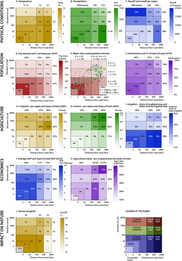
Figure 2. Assessment results across ALDIS zones. (A) Average annual temperature; (B) average annual precipitation; (C) runoff per capita (shaded) and average annual runoff (numbers); (D) population density (shaded) and percentage of population (numbers); (E) major cities (over 5 million and 1–5 million people) juxtapositioned on the population density graph by geographic zones; (F) urban population as percentage of total population (urbanisation, shaded) and the zone's percentage of the total global urban population (numbers); (G) cropland per capita (shaded) and share of world's total cropland area (numbers); (H) pasture per capita (shaded) and share of world's total pasture area (numbers); (I) share of irrigation area of total cropland area (shaded) and share of total irrigated area (numbers); (J) gross domestic product (GDP PPP) per capita (shaded) and share of total world's GDP (numbers); (K) agricultural value per cropland area (shaded) and percentage of total value (numbers); and (L) human footprint. Note: logarithmic scale on both axes. See table 1 for data sources used and data itself in online Supplementary. The values on the top and the right of the graphs refer to the metazones (see figure 1(B)).
Download figure:
Standard image High-resolution imageOther than that, a distinct pattern appears where coastal zones receive the highest precipitation and produce the highest runoff, while the continental zones produce the lowest (figures 2(B), (C); S2(C), (D); S3(C) and (D)); distinct orographic effects are masked by the strong influence of humid climates on the zone averages. In contrast, temperature decreases with elevation (figure S2(B)), and increases slightly inland (figure S3(B)). Due to the rather dense population in the coastal zones (see next sub-section), the per capita water resources are very low there when compared to other zones (figure 2(C)).
3.1.2. People
Population density varies greatly across the ALDIS zones. The zones can be grouped into three largely different clusters, each having a relatively similar population density. First, by far the greatest density is found in the coast zone (figures 2(D)–(F)). In year 2010, 7% of the world's population inhabited this zone (figure 2(D)), which covers only 2% of the world's total land surface area (figure 1(A)). This results in an average population density of 213 cap km−2 (persons per km2). Second, the immediate coast, coastal inland and inland lowland zones exhibit a density of 125–144 cap km−2. Third, the remaining zones have a density between 27 and 59 cap km−2. Altogether, 1.9 billion people (27% of world's total; figure 2(D)) inhabit the near-coast zone (i.e. an area that is located less than 100 km from the coast, and has an elevation lower than 100 m), in a surface area of 12.3 million km2 (9% of total land area; figure 1(A)).
Urbanisation follows a somewhat different pattern across the zones, compared to population density (figure 2(F)). In the immediate coast and coast zones, the rate is higher than elsewhere, namely 69%. Coastal lowlands, coastal midlands, coastal highlands, and inland highlands follow with rates of 59%, 53%, 51%, and 54%, respectively. The other zones range between 44% and 48%, except continental highlands (32%), which are clearly less urbanised than the other zones.
Overlaying population density and cities across zones reveals that cities tend to be concentrated along the near-coast zone. Over half (17 out of 30) of the world's largest cities with a population over 5 million, are located in that zone (figure 2(E)). Moreover, more than one third (88 out of 226) of the cities with a population over one million are located there (figure 2(E)). Large urban agglomerations cluster around the diagonal of figure 2(E), but seem remarkably absent in the water-richest part of the planet, namely the continental lowlands (figure 2(C)). The areas below 1000 m in elevation and less than 1000 km from the coast have attracted a remarkable number of major cities.
3.1.3. Agriculture
While population tends to be concentrated in proximity to the coast, food is largely produced further away. The near-coast zone has a relatively small share of croplands (12% of world total) and an even smaller share of pasture (5%) (figures 2(G) and (H)). The midland meta-zone has the largest share of the agricultural lands, representing 65% of global cropland and 60% of the world's pasture areas, explaining its importance in total agricultural value despite its low per unit area values. In general, the cropland per capita decreases with elevation and distance to coast (figures S2(H) and S3(H)), whilst for pasture the opposite is the case (figures S2(I) and S3(I)). The largest values for cropland are found in continental midlands (0.41 ha cap−1), and for pasture in continental highlands (1.19 ha cap−1). These can be compared to the immediate coast zone, where the values are 0.06 ha cap−1 for cropland and 0.05 ha cap−1 for pasture.
Lowlands have more intensive irrigation based agriculture compared to other zones (figure 2(I)). On average, 34% of the cropland area is irrigated in lowlands; whereas in midlands and highlands the values are 15% and 19%, respectively (figure 2(L)). Of all of the 305 million ha that are equipped for irrigation, almost half is still located in midlands, as that zone has 65% of the total cropland (figure 2(J)).
3.1.4. Economy
Two factors were included in this group, namely GDP per capita and agricultural value (value of agricultural output). Although GDP might not cover the range of economic performance, we selected it to indicate economic output, since it indicates economic activity in the most straightforward way. GDP in the year 2010 is fairly high (7770–8120 USD cap−1; depending on ALDIS zone) in the near-coast zone (figure 2(J)). GDP per capita reduces when moving inland (2510–3930 USD cap−1 in inland meta-zone and 1600–3180 USD cap−1 in continental meta-zone) and with increasing elevation (3180–7170 USD cap−1 in midland meta-zone and 2050–2590 USD cap−1 in highland meta-zone). The 27% of global population living in the near-coast zone produces 42% of the world's GDP.
In contrast to the high GDP in the near-coast zone, only 11% of the agricultural value is located there (figure 2(K)). So, the sources of GDP in that zone are in other components of the economy. Over half of the total agricultural value is located in the midlands meta-zone, although the agricultural value per hectare of cropland is relatively low there, averaging 1800 USD ha−1, when compared to the global average of 2250 USD ha−1. The agricultural value is largest in the highland meta-zones (on average 3800 USD ha−1), with over double the values of the midlands meta-zone and many coastal zones (figure 2(K)).
3.1.5. Impact on the environment
To assess the human impact on the environment, we used the human footprint index, which is computed as the human influence index (HII) normalised by biome and realm (WCS/CIESIN 2005). HII is a combination of nine variables, including population pressure, landuse, infrastructure, and human access. The highest human footprint is observed in the near-coast (indicator value of 21) and inland lowland zones (20) (figure 2(L)), whereas the lowest value is found for continental lowlands. In general, the human impact on the environment decreases with the distance from coast (figure S3(M)), while elevation beyond the lowland meta-zone does not have a strong relationship with human footprint (figure S2(M)). As can be expected, the population density goes to a large extent hand in hand with human footprint (see figures 2(D) and (L)). However, in densely populated lowlands, particularly in areas located less than 20 km to the coast, the human footprint is comparatively speaking less pronounced than population density. Similarly, the human footprint is relatively high in highlands in comparison to population density. There appears to be a negative relation between water availability per capita and human footprint (see figures 2(C) and (L)). Therefore, it seems that a high human footprint is not just related to population density, but increases with lower water availability in relation to population size.
3.2. Temporal evolution of selected factors
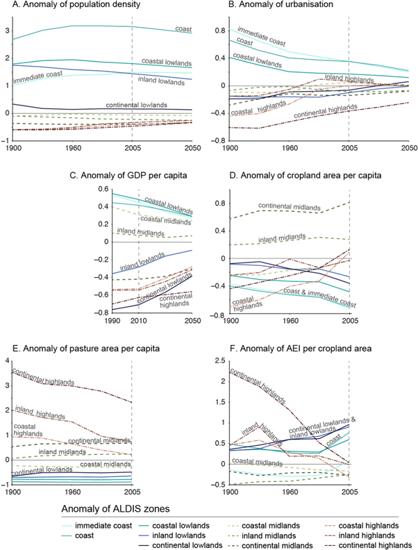
We analysed the temporal evolution of population, GDP, and agricultural activities on the basis of historical data for the period 1900–2005 or 2010, and projected development up to the year 2050 (in the case of population and GDP). We present the results by using anomaly plots (figure 3) in which zero stands for the global average value in the given year whilst the temporal trends of absolute and scaled values are presented in the online supplementary information (figure S1). Moreover, we present literature-based estimates of sea-level rise impacts on coastal area.
Figure 3. The temporal evolution of anomaly (i.e. deviation from global average) of selected parameters by geographic zone. (A) Population density; (B) urbanisation (urban population % of total population); (C) GDP; (D) cropland area per capita; (E) pasture area per capita; and (F) area equipped for irrigation (AEI) per cropland area. See also figure S1 where trendlines of absolute values and scaled values for year 1900 are presented.
Download figure:
Standard image High-resolution image
3.2.1. Population
As identified in the previous section, our results show a strong concentration of people in the coastal zones (figure 2(D)). When exploring the population density anomalies and trends over time (figure 3(A)), the pattern already visible in figure 2 does not change much over time, with near-coast zones having the highest population densities and highland meta-zone the lowest. While the coastal zone experiences a small decrease in anomaly, the population densities in the three highlands zones are becoming closer to the global average.
Contrary to anomalies in population density, which are relatively stable over time, the anomalies in urbanisation (urban population as a % of total population) seem to converge clearly over time. While in the year 1900 the anomaly of different zones ranged from −0.6 to 0.8, by 2005 the range was from −0.4 to 0.4, and is projected to be from −0.3 to 0.25 in 2050 (figure 3(B)). This shows that in the year 1900 urbanisation occurred dominantly in near-coast zones (high positive anomalies), being far less pronounced in continental and inland highlands (negative anomalies). But over time urbanisation has occurred in all areas, bringing them closer to the global average and thus reducing spatial differences. Throughout the study period, the near coast zone exhibits the highest urbanisation rates, whereas continental highlands have experienced the lowest rates. The other zones are close to the global average.
3.2.2. GDP
In terms of the temporal evolution of the GDP per capita anomaly, the general pattern is similar to that of the urbanisation anomaly (figure 3(C)), although the spread around the global average is broader in the year 2005. While the three zones forming the near coast zone have the highest GDP anomaly (around 0.5 in year 2010), the lowest anomaly is in continental lowlands (−0.75). The coastal midlands zone has a relatively high GDP anomaly compared to its urbanisation. This indicates that there are considerable differences in GDP/capita between the ALDIS zones. However, these differences between the zones reduce over time and are projected to be much lower in 2050 compared to the situation in 2005.
3.2.3. Agriculture
Whereas our results indicate a clear converging pattern in the cases of population density and economic output (GDP), the patterns of cropland and pasture areas per capita (figures 3(D) and (E)) are very different. These are dominated not by the near-coast zone (as is the case for population density and GDP), but rather by inland and continental midlands in the case of cropland and by inland and continental highlands in the case of pasture.
In the trends in the anomaly of cropland area, this dominance of the inland and continental midlands persists over time. There is, however, a clear trend in the anomalies in the coastal and lowland zones becoming even more negative (i.e. there is a reduction in relative cropland area/capita), and those in the highlands becoming less negative (up to global average in 2005) (figure 3(D)). This indicates a shift from cropland in the lower and coastal zones towards higher elevations (>1000 m) throughout the period 1900–2005. In contrast to cropland area, the anomaly of pasture area declined in highland zones (figure 3(E)), indicating perhaps replacement of pasture by cropland. In all of the other zones, the anomaly remained rather stable, showing only a slight increase in the case of continental midlands.
The anomaly for the area equipped for irrigation (AEI) shows in part a similar tendency to the case of pasture, i.e. the anomalies in highlands zones show clear declining trends (figure 3(F)). However, the AEI anomaly increased in most of the coastal and lowland zones. In midland zones, the AEI anomaly stayed rather stable, between −0.5 and 0.
3.2.4. Sea-level rise
An important factor that is expected to affect coastal zones in the 21st century and beyond relates to climate change induced sea-level rise. Between 1901 and 2010, observed sea level rise was between 17 and 21 cm (IPCC 2013), with more rapid rise in the most recent decades (IPCC 2013). Sea-level rise for the 21st century is very likely to be greater than that observed for the 20th century. An additional rise is projected between 1995 and 2100 of 26 cm to 82 cm (IPCC 2013), depending on the scenario and model; and sea-level will continue to rise for centuries after that (Church et al 2013). In addition, locally sea-level rise can deviate substantially from the global mean (Church et al 2013). Reasons for such local differences include glacial isostatic adjustment and changes in gravity due to water and ice mass redistribution.
A rise in sea-level of about one meter would obviously affect our results in terms of population and GDP, primarily the zone <5 m above sea level (Dasgupta et al 2009). Whilst sea-level rise may have a limited effect on the overall ALDIS zones, our results indicate that effects on the economy and people may be substantial. The zone lower than 5 m may be relatively small (1.9% of total surface area; figure S2), but its contribution to the total GDP is almost four times higher (7.2%; figure S2) and its share of the total population is almost three times higher (5.6%; table 2). While population in this 5 m zone in relation to total global population is not projected to increase, by 2050 the absolute population is projected to grow from today's 383 million people to 495 million by 2050. These people and assets will thus become increasingly more exposed to natural hazards like storm surges.
Table 2. Comparison of our results to previous studies. Results are shown as % of total population, except the last row where total population is shown in billions.
| <5 m above sea level | Near-coast zonea | <100 km from coast | <200 km from coast | <400 km from coast | |||||||||||
|---|---|---|---|---|---|---|---|---|---|---|---|---|---|---|---|
| 1990 | 2010 | 2030 | 1990 | 2010 | 2030 | 1990 | 2010 | 2030 | 1990 | 2010 | 2030 | 1990 | 2010 | 2030 | |
| Hinrichsen (1990) | 60% | ||||||||||||||
| Hinrichsen (1996) | 50% | 70% | 66% | ||||||||||||
| Cohen and Small (1998b)b | 37% | ||||||||||||||
| Small and Nicholls (2003) | 23% | ||||||||||||||
| Dasgupta et al (2009)c | 5.6% | ||||||||||||||
| This study (%) | 5.4% | 5.6% | 5.5% | 28% | 28% | 27% | 39% | 39% | 38% | 52% | 51% | 51% | 69% | 68% | 67% |
| This study (109 people) | 0.29 | 0.38 | 0.46 | 1.5 | 1.9 | 2.2 | 2.1 | 2.7 | 3.2 | 2.7 | 3.5 | 4.2 | 3.6 | 4.7 | 5.6 |
aBelow elevation of 100 m and closer than 100 km from the coast (see figure 1(B)). bCohen and Small (1998b) refer to year 1994. cDasgupta et al (2009) refer to year 2000, and include only development countries to their study (4.4 billion people).
A global assessment of coastal cities showed that by the 2070s, the population exposed to flooding may increase three-fold, and that the value of assets exposed to flooding may be even ten times the current levels (Nicholls et al 2008) due to climate change, subsidence and socio-economic growth. A more recent follow-up of this study incorporating flood probabilities showed that there might be a ten-fold increase in flood risk (expressed in terms of economic damages per year) in coastal cities by 2050 (Hallegatte et al 2013).
4. Discussion
In this article we developed new insights and understanding on a number of fronts on global geospatial patterns of human development and environment. The most important novelties and new findings of our analysis are discussed below.
4.1. Population pressure along the coast is somewhat larger than estimated recently
Small and Nicholls (2003) found that in 1990 around 1.2 billion people lived in the near-coast zone (below an elevation of 100 m and closer than 100 km from the coast). Our assessment for the same year suggests 1.5 billion inhabitants, or 28% of the world's total population. Therefore, our results suggest that the pressure on this zone may be even greater than earlier estimated. The difference between the results is probably mostly due to the Increased resolution datasets used in our study as compared to those used by Small and Nicholls (2003).
Hinrichsen (1990) estimated that 60% of world's population lived within 100 km of a coastline. He later revised this estimate, to state that: 50% of total global population lived within 200 km of a coastline at the time of his analysis, with over two-thirds of the population within 400 km of a coastline; and by 2025 70% would live within 200 km of the coastline (Hinrichsen 1996). Cohen and Small (1998b) estimated that the share of the population living closer than 100 km would be much smaller; as of 1994, 37% would have been living in the zone that we refer to as the coastal meta-zone (see figure 1). Our estimate for that percentage as of 1990 is 40%, and 39% for 2010 (figure 2(E); table 2), indicating that the population pressure is somewhat larger in the coastal zones than proposed by Cohen and Small (1998b), but smaller than estimated by Hinrichsen (1990). We further found that 52% of global population lived closer than 200 km to the coast in year 1990, while by using a 400 km threshold this ratio was 69%. These values are in line with the findings of Hinrichsen (1996).
The relative accumulation of the population at the proximity to the coast, as projected by Hinrichsen (1996), is not seen in our results. Instead, the share of population that lived closer than 200 km from coast has remained fairly stable (52% in 1990 and 51% in 2010). The same is valid for population that lived closer than 400 km from coast (69% in 1990, 68% in 2010; table 2). By year 2030, no large changes are projected, the values being 51% and 67%, respectively. Naturally, the number of people in these zones has increased remarkably: while in the year 1990 2.7 billion people lived closer than 200 km from coast, this number has increased to 3.5 billion by the year 2010, and is projected to further increase to 4.2 billion by the year 2030 (table 2). However, the inland population has grown even more rapidly.
The population in the near-coast zone has increased from 0.4 billion (26% of total population) in 1900 to 1.9 billion (28%) in 2010. It is projected that by 2050 this zone will be inhabited by over 2.4 billion people (26%), of which around 80% will live in cities. The urbanisation has increased in this zone from 25% in year 1900 to 63% in year 2010, which is well above the global average values (1900: 16%; 2010: 51%; and 2050: 70%). This near-coast zone is particularly sensitive to climate change, due to projected sea level rise and intensified storms in the future (Hallegatte et al 2013, Nicholls et al 2014, Muis et al 2015). This quarter of world's population will thus face increasing challenges. The greatest challenge will be faced by the people living less than 5 m above sea level, as they are most affected by sea level rise (Dasgupta et al 2009, Church et al 2013). We found that 5.6% of global population lived in that zone in year 2010 (table 2). That is in line with the findings of Dasgupta et al (2009), who found that 5.6% of global population lived in that zone in year 2000 (their analysis does not have global coverage; it covers 84 developing countries, equivalent to a population of 4.4 billion).
Comparison of our results with those in mountain areas (Meybeck et al 2001, Messerli et al 2004, Viviroli et al 2007) is not directly possible, since those studies define mountains not only on the basis of elevation from the average sea level, but include also various relief characteristics of the terrain into their definitions. Furthermore, Viviroli et al (2007) introduced a view that uses hydrological catchments as defining components and, within these, considers the prevailing climates in the highland and the lowland zones as key elements (see also Viviroli and Weingartner 2004). These additions could help refining the picture drawn in the present study in the direction of highland-lowland linkages, particularly when it comes to water resources and food production (Messerli et al 2004). This concerns, for instance, high-risk areas in the arid and semi-arid climates where the seasonal precipitation regimes are highly variable and runoff contributions from higher elevations are therefore vital for water supply and food production downstream. These contributions might be mistaken as very modest or even insignificant when compared to the vast runoff values observed in the water-abundant lowlands of the humid tropics. It should also be noted that important seasonal contributions of the more elevated areas in boreal and colder regions are not apparent in our study, e.g. melting of snow and ice in spring and summer.
4.2. Population density and economic output between zones are becoming less diverse
With regard to population density, urbanisation (urban population as a % of total population), and GDP per capita, the anomalies of the ALDIS zones are converging towards the global average (figures 3(A)–(C)). This means that the zones are becoming less diverse and more similar to one another. In particular, large urban agglomerations are spreading, not only to coastal and low-lying areas but also to areas with high elevation (figure 3(B)). Until recently, the immediate coast has been the most urbanised zone, but the coastal zone has gradually caught up. Coastal lowlands follow with a time delay of around three decades (figure S1(C)). Other zones follow with a lag of around 60–80 years, with varying rates (figure 3(B)).
Our results thus partly contrast with those of both Hinrichsen (1990, 1994, 1996, 1999) and Small and his colleagues (Small et al 2000, Small 2001, Small and Nicholls 2003, Small 2004, Small and Cohen 2004, Fragkias et al 2013). They shared the concern that areas in coastal proximity accumulate an increasing share of the world's population, urban population, urban land area, and wealth. While our findings agree that the coastal area is becoming increasingly populated and wealthy, and will remain the wealthiest and most populated area for the coming decades, the more distant and highest areas are growing faster than the coastal areas (figures 3 and S1(A)–(F)).
4.3. Croplands are being decoupled from population centres
We found that over the past century, cropland and pasture areas increased mostly in areas outside the population hotspots. This was seen when we analysed the anomaly time-series and trend of cropland and pasture (figures 3(D), (E) and S1(G)–(J)), and combined that information with the population time-series (figures 3(A), S1(A) and (B)). Our analysis revealed that in lowland zones (altitude less than 100 m) the cropland area per capita has decreased (in relation to global average), while it has increased in almost all other zones (table 3). Since 1990, the absolute cropland area has even decreased in the lowlands and coastal meta-zones, whereas in all other meta-zones cropland area has increased in each time-step (table 3). The dynamics of pasture are somewhat different from cropland, as since 1960 the absolute area has remained fairly constant in all the meta-zones (table 3).
Table 3. Cropland (a) and pasture (b) distribution in meta-zones over time period 1900–2005. Both absolute area and area per capita are presented for each timestep.
| (a) Cropland | 1900 | 1930 | 1960 | 1990 | 2005 | ||||||
|---|---|---|---|---|---|---|---|---|---|---|---|
| Meta-zone | Definition | Area [106 km2] | ha cap−1 | Area [106 km2] | ha cap−1 | Area [106 km2] | ha cap−1 | Area [106 km2] | ha cap−1 | Area [106 km2] | ha cap−1 |
| '<5 m' | <5 m | 0.27 | 0.35 | 0.33 | 0.31 | 0.39 | 0.25 | 0.41 | 0.14 | 0.32 | 0.08 |
| Lowlands | <100 m | 2.80 | 0.40 | 3.38 | 0.38 | 4.01 | 0.31 | 4.27 | 0.19 | 3.41 | 0.12 |
| Midlands | 100–1000 m | 5.27 | 0.64 | 6.77 | 0.67 | 8.61 | 0.59 | 9.51 | 0.38 | 10.17 | 0.32 |
| Highlands | >1000 m | 0.44 | 0.32 | 0.63 | 0.35 | 1.05 | 0.38 | 1.42 | 0.24 | 2.00 | 0.24 |
| Coastal | <100 km | 2.23 | 0.37 | 2.81 | 0.34 | 3.63 | 0.30 | 3.97 | 0.19 | 3.63 | 0.13 |
| Inland | 100–500 km | 3.39 | 0.55 | 4.21 | 0.56 | 5.34 | 0.50 | 5.92 | 0.32 | 5.79 | 0.24 |
| Continental | >500 km | 2.89 | 0.67 | 3.77 | 0.73 | 4.70 | 0.63 | 5.31 | 0.40 | 6.15 | 0.34 |
| GLOBAL | 8.50 | 0.51 | 10.79 | 0.52 | 13.68 | 0.45 | 15.20 | 0.29 | 15.58 | 0.23 | |
| (b) Pasture | |||||||||||
| '<5 m' | <5 m | 0.13 | 0.17 | 0.20 | 0.19 | 0.32 | 0.20 | 0.34 | 0.12 | 0.37 | 0.10 |
| Lowlands | <100 m | 1.30 | 0.19 | 2.04 | 0.23 | 3.17 | 0.24 | 3.27 | 0.15 | 3.53 | 0.12 |
| Midlands | 100–1000 m | 7.58 | 0.92 | 11.99 | 1.18 | 18.57 | 1.28 | 19.84 | 0.80 | 19.91 | 0.62 |
| Highlands | >1000 m | 4.03 | 2.92 | 5.62 | 3.17 | 9.10 | 3.24 | 10.24 | 1.75 | 9.97 | 1.19 |
| Coastal | <100 km | 1.84 | 0.30 | 2.81 | 0.35 | 4.37 | 0.36 | 4.55 | 0.22 | 4.59 | 0.17 |
| Inland | 100–500 km | 4.74 | 0.77 | 7.39 | 0.97 | 11.70 | 1.08 | 12.28 | 0.66 | 12.18 | 0.51 |
| Continental | >500 km | 6.32 | 1.48 | 9.44 | 1.83 | 14.76 | 1.99 | 16.52 | 1.23 | 16.64 | 0.93 |
| GLOBAL | 12.91 | 0.78 | 19.65 | 0.94 | 30.83 | 1.01 | 33.34 | 0.63 | 33.41 | 0.48 | |
The cropland area has increased most rapidly in the highland meta-zone (five-fold increase within the past century; table 3). At the same time, the relative population density (in relation to global average) has remained rather stable in all zones (figure 3(A)), while the absolute values have continually increased in all zones (figure S1). This strongly indicates that, globally, food production is decoupling from population centres. This is in line with the rapidly increased global trade (Hoekstra and Hung 2005, Yang et al 2006, Fader et al 2013, Kastner et al 2014) and growing dependency on trade to ensure national food supply across the globe (Porkka et al 2013, Kummu et al 2014). When looking to the future, sea level rise may have considerable impact on agriculture, as many important cropland areas, such as Mekong Delta, are located lower than 5 m from mean sea-level. Our results show that 2.0% of the world's arable land and 1.1% of pasture is located in this zone (table 3).
Unfortunately, we were not able to take fully into account the possible intensification of agriculture. We only have gridded timeseries for areas equipped for irrigation (Siebert et al 2015), whilst datasets for other activities related to the intensification of agriculture (e.g. application of agrochemicals, mechanisation, and new crop varieties) are not yet available at the global scale for multiple time-steps. In all zones, AEI has increased in relation to cropland area (figures 3(F) and S1). In relation to the global average value, however, it has grown most rapidly in coastal zones, while the anomalies in the highlands meta-zone have dropped remarkably (figure 3(F)). This indicates either that in coastal areas the large population densities require more intensive agriculture or that due to land pressure, agriculture has evolved to be very intensive. This is in line with the findings of Neumann et al (2011), who found that population density coincides well with the spread of irrigated land. However, it would also be important to understand how the total food production has developed in each zone over the 20th century, and whether a similar pattern of decoupling the food production and population centres can be seen there. This remains an entry point for future studies.
While cropland areas have moved further away from the coast, particularly to highland zones, pasture area has decreased in highlands (figures 3(D), (E) and table 3). This might indicate replacement of pasture by cropland in those areas, but more detailed studies are needed to specify whether this is actually the case.
4.4. Limitations of the study and future directions
We performed the analysis on the basis of a spatial resolution of 2.5 arc-min × 2.5 arc-min (ca 5 km × 5 km at the equator). Increasingly, new datasets are becoming available at a spatial resolution of 30 arc-sec × 30 arc-sec (ca 1 km × 1 km at the equator) or finer, and by using this resolution the analyses could become more accurate. This is particularly important in the immediate proximity of the coastline, which in our analysis suffers the most from the spatial resolution of the available data. This problem has been discussed thoroughly in previous studies (Small et al 2000 and more recent works of the same authors as well as Lichter et al 2011). Another aspect of analysis that would benefit from higher resolution data is the extent of urban areas, particularly in terms of population and GDP distribution. However, we believe that the resolution used in this paper is sufficient for the detection of macro-level patterns of the questions under study.
With respect to analysing global population settlement behaviour over time, we focussed in this study on two geographical factors: elevation and proximity to the coastline. However, settlement behaviour is also influenced by cultural, demographic, and economic factors. For instance, Acemoglu et al (2001) and (2002) argue that population distributions are driven by the strength of institutions, which enable economic growth, and in turn result in higher population densities. Furthermore, topographic factors such as local relief, slope gradient and slope aspect are also of importance due to the limitations they impose on accessibility and utilisation of more elevated areas (Gardner et al 2013). The relative strength of geographic drivers versus other drivers (such as economic drivers) and how this possibly changes through time (as the nature of economies change) remains a topic for future research.
Future research could build on the current findings in several ways. One is to include political borders, most notably country borders. Over the years, there has been much analysis and discussion of the importance of access to the sea, as summarised by Collier (2007). Country-specific analyses on proximity to the coast and elevation from the sea could be of great general political and scholarly interest. Another direction could be to further analyse the relations of relief characteristics (such as steepness and variability of slopes as well as mountain-related natural hazards) to human population distribution, by extending the previous studies (Meybeck et al 2001, Messerli et al 2004, Viviroli et al 2007, Penna and Borga 2013). Third possible direction for future analyses would be to include boundaries of geographic units such as river basins or climatic zones, and by such means link the analyses even tighter to climate change scenarios. Moreover, it would be quite attractive to study systematically the relation of elevation to various vulnerabilities such as combinations of highly populated and low-GDP areas (see Varis et al 2012, 2014). Population pressure is usually related to population count per land area (population density). However, our results would suggest that population density in relation to available water resources is also very indicative of population pressure. The comparison of figures 2(C), (D) and (L) indicates that a high human footprint also appears to have a strong relation with water availability (runoff per capita). Whether this is an artefact due to the character of the Human Footprint Index (WCS/CIESIN 2005) or a genuine scientific result also deserves further investigation.
5. Conclusions
We performed a global-scale geospatial analysis of the distribution of human population and various factors in relation to the proximity to the coast and elevation. Those factors were grouped into five clusters: physical conditions, people, agriculture, economy, and impact on environment. We also developed a generic zoning of the Earth's land area with respect to these two dimensions, named ALDIS zoning. Our results reinforce the importance of knowing and comprehending the spatial patterns of global population distribution, its relationship with key physical factors, and the vast potential of contemporary datasets and analysis tools. This has great importance in particular for studies aiming to understand potential climate change related impacts on vulnerable coastal and mountain areas. Besides achieving a thorough overview at the global scale it is also important to remember the relevance of the local and regional scales, where the impacts of global change will materialise in all their diversity.
Our findings extend the current knowledge on three fronts:
- Population pressure in the proximity of the coast (<100 km from a coast) is somewhat larger than previously estimated in existing studies (Cohen et al 1997, Cohen and Small 1998a, 1998b, Small 2001, Small and Nicholls 2003, Small 2004, Small and Cohen 2004) but lower than estimated by Hinrichsen (1990). This reinforces the previous findings that efforts on mitigation and adaption to the impacts of future sea level rise and more intense storms on immediate coast are within high concern.
- Urbanisation and economic output (GDP) are becoming less diverse throughout the globe, in terms of their relationship to the zoning used. This is in contrast with other results indicating that economic activity would continue to concentrate in the proximity of coast. Even though people and wealth continue to accumulate in coastal proximity, their growth is even faster in other areas.
- The distribution of cropland and pasture areas is becoming increasingly decoupled from population hotspots. Cropland per capita is growing in highlands but decreasing elsewhere. In contrast, pasture per capita is decreasing rapidly in highlands, and is also decreasing in other zones, though less sharply.
All in all, our results indicate that population densities and economic productivity are becoming less diverse in relation to elevation and distance to the coast. Moreover, our findings suggest that food is being produced further and further away from where people live. As a result, more and more elevated areas of the globe might be experiencing increasing pressure to utilise land and water resources. Projected climate change induced sea level rise and continuous population growth in already resource scarce areas might further increase the stress on less populated areas. Our findings thus underline the urgent importance of further, more detailed studies on how the rapid global changes affect different altitudes and what impacts follow for the particularly vulnerable mountain areas with their specific physiographic and socioeconomic features.
Acknowledgments
This work was partially funded by the Finnish Cultural Foundation through the Professoripooli Funding Scheme and Maa- ja vesitekniikan tuki ry. In addition, MK was funded by the Academy of Finland project SCART (grant no. 267463) and PJW by a VENI grant (grant no. 863-11-011) from the Netherlands Organisation for Scientific Research (NWO).