

Abstract
Over the course of six years (2006–2011), equivalent black carbon (eqBC), coarse aerosol mass (PM1–10), and surface ozone (O3), observed during the monsoon onset period at the Nepal Climate Observatory–Pyramid WMO/GAW Global Station (NCO-P, 5079 m a.s.l.), were analyzed to investigate events characterized by a significant increase in these short-lived climate forcers/pollutants (SLCF/P). These events occurred during periods characterized by low (or nearly absent) rain precipitation in the central Himalayas, and they appeared to be related to weakening stages (or 'breaking') of the South Asian summer monsoon system. As revealed by the combined analysis of atmospheric circulation, air-mass three-dimensional back trajectories, and satellite measurements of atmospheric aerosol loading, surface open fire, and tropospheric NOx , the large amount of SLCF/P reaching the NCO-P appeared to be related to natural (mineral dust) and anthropogenic emissions occurring within the PBL of central Pakistan (i.e., Thar Desert), the Northwestern Indo-Gangetic plain, and the Himalayan foothills. The systematic occurrence of these events appeared to represent the most important source of SLCF/P inputs into the central Himalayas during the summer monsoon onset period, with possible important implications for the regional climate and for hydrological cycles.
Export citation and abstract BibTeX RIS

Content from this work may be used under the terms of the Creative Commons Attribution 3.0 licence. Any further distribution of this work must maintain attribution to the author(s) and the title of the work, journal citation and DOI.
1. Introduction
The Himalayas, often referred to as the third pole of the Earth, have recently received a great deal of scientific attention as a hot spot for climate change and its potential adverse impact on humans and the environment. The southern Himalayas are a well-known atmospheric brown cloud hot spot, i.e., a region characterized by persistent high levels of short-lived climate forcers and pollutants (SLCF/P) such as ozone (O3), black carbon (BC), and other aerosol particles (see UNEP and GAW 2011). Indeed, as shown by previous investigations (e.g., Bonasoni et al 2010, Shrestha et al 2010), the Himalayas can be strongly affected by vertical upward transport of air masses that are rich in anthropogenic pollutants and mineral dust, especially during the pre-monsoon season. During this season, 'acute pollution events' characterized by high O3 (64.7 ± 8.6 nmol mol−1), BC (1077 ± 470 ng m−3), and PM1–10 (typically more than 12 μg m−3), were identified by Marinoni et al (2010, 2013) and were even detected inside the Tibetan Plateau (Zhao et al 2013). Large amounts of absorbing particles, such as BC and mineral dust, can have multiple effects. For example, scattering and absorption of solar radiation by the atmospheric brown clouds produce a 'solar dimming effect' (Ramanathan et al 2005). Absorbing aerosols may intensify the northern Indian summer monsoon through the so-called 'elevated heat pump' effect (Lau and Kim, 2006). Bollasina et al (2008) argue that excessive aerosol loading during the pre-monsoon season (especially during May) leads to reduced cloud cover and precipitation, which in turn heat the land surface, leading to strengthening of the monsoon in June and July. Recent studies have pointed out that BC transport and deposition can significantly affect the cryosphere by modifying snow/ice reflectance and thus altering the snowmelt rate and cryosphere spatial coverage, with implications for the regional and global climate, as well as the hydrological regimes and the availability of fresh water over South Asia (e.g., Flanner et al 2009, Xu et al 2009, Ming et al 2008, Yasunari et al 2010, Marcq et al 2010, Qian et al 2011, Kopacz et al 2011).
Even if the monsoon season is widely indicated to be characterized by the occurrence of 'pristine' atmospheric conditions in the Himalayas (e.g., Carrico et al 2003, Bonasoni et al 2010, Ram et al 2010, Hyvärinen et al 2011a, 2011b), previous investigations have pointed out the occurrence of 'acute pollution events' during the onset period (i.e., May–June), when the onset period coincides with dry-spell periods that are characterized by a weakening or break in the monsoon precipitation regime (Hedge et al 2007, Marinoni et al 2010, 2013). Because these events are characterized by high mineral dust, BC, and O3, they represent the most important direct SLCF/P input toward the highest Himalayas and their perennial glaciers during the summer monsoon. However, only investigations of case studies (e.g., Hedge et al 2007, Bonasoni et al 2008, Zhou et al 2008) or multi-year analyses stating event frequency (e.g., Marinoni et al 2010, 2013) have been published. In particular, no information about the conditions that could favor the occurrence of these events or their impact on the background atmospheric composition of the central Himalayas has been published yet. The specific aim of this work is to investigate the possibility that, during the monsoon onset period, when 'breaks' or a decrease in rain precipitation occur, significant increases of SLCF/P can systematically affect the NCO-P and the southern Himalayas. But we also would like to provide indications about the atmospheric conditions and the regional emission processes triggering event occurrence. For this purpose, a combined analysis involving in situ atmospheric SLCF/P observations and multi-sensor satellite data has been considered to highlight the variability of rainfall, aerosol loading, and atmospheric circulation in South Asia, with a special emphasis on the Himalayas and the Indo-Gangetic plains.
2. Methods
We took into consideration the atmospheric observations carried out at the Nepal Climate Observatory–Pyramid (NCO-P), a global station of the Global Atmosphere Watch program, which is part of the World Meteorological Organization and is located in the high Khumbu Valley (Nepal) at 5079 m a.s.l. (Bonasoni et al 2010), with the aim of investigating the systematic occurrence of acute pollution events in the Himalayas during the monsoon onset period (May–June). At this GAW/WMO Global Station, continuous measurements of atmospheric composition (trace gases and aerosol properties) were begun in March 2006. Analysis of these measurements pointed out the existence of efficient and systematic vertical transport of anthropogenic pollutants and mineral dust from the Himalayan foothills and Indo-Gangetic Plains, especially during the dry pre-monsoon season.
In this work, we analyzed in situ data of surface O3, equivalent BC (eqBC), and aerosol mass concentration  observed during the period 2006–2011 for the purpose of investigating the occurrence of SLCF/P transport to the high Himalayas during the monsoon onset period. At the NCO-P surface, O3 is measured using photometric analysers (Thermo Tei 49C and Tei49i; for more details, see Cristofanelli et al 2010). Equivalent BC is measured using a multi-angle absorption photometer (MAAP 5012, Thermo Electron Corporation; for more details, see Marinoni et al 2010). PM1−10 (i.e., the mass concentration of the coarse fraction of atmospheric aerosol with 1 μm < Dp < 10 μm) is obtained by using an optical particle counter (OPC GRIMM 190), as better described by Marinoni et al (2010). In this work, PM1−10 is considered a proxy for mineral dust aerosol at the measurement site. As reported by Decesari et al (2010), mineral dust is the main component of PM10 (i.e., the mass concentration of atmospheric aerosol with Dp < 10 μm) at the NCO-P because mineral dust accounts for more than half this mass. At the same time, as reported by Yasunari et al (2010), anthropogenic aerosols, which are rich in combustion products (i.e., BC), are present mostly in sub-micron aerosol particles. Thus, in agreement with other experimental studies at high-altitude measurement sites (see also Carrico et al 2003, Van Dingenen et al 2005, Marenco et al 2006, Marinoni et al 2010, Decesari et al 2010), we considered
  as a viable proxy for the presence of mineral dust at the NCO-P.
Rain measurements at three automated weather stations (AWSs) located along the Khumbu Valley—Lukla (2660 m a.s.l., ∼31 km from the NCO-P), Namche (3560 m a.s.l., ∼20 km), and Pheriche (4258 m a.s.l., ∼7 km)—and at one AWS at the Pyramid laboratory (5050 m a.s.l., 300 m from the NCO-P) were analyzed to identify dry spells during the analyzed monsoon onsets. At these stations, rainfall is determined on an hourly basis by using a rain gauge (Lastem DQA035; see Bollasina et al 2002). We considered the daily average values of 24 h accumulated rain at the four stations to provide a robust characterization of the occurrence of rain along the Khumbu Valley. The process of averaging among the AWSs lowers the chance of bias due to topography and to spatial under-representation of in situ rain measurements.
To investigate the spatial and temporal patterns of rain during the monsoon onset period, we analyzed data from the Tropical Rainfall Measuring Mission (TRMM; see Huffman et al 2007) TRMM_3B42_Daily.007 data set. For spatial distribution of absorbing aerosol (dust and pollution), we used the ozone monitoring instrument (OMI) on board the Aura satellite. In particular, we used the OMI UV Aerosol Index (UVAI), OMTO3D.003 data set, as a type of measurement of the atmospheric loading of absorbing aerosol (Duncan et al 2003). As reported by Torres et al (2010) and Shrestha et al (2010), the OMI AI is a robust tool for investigating the presence of absorbing aerosol (carbonaceous aerosols and mineral dust) in the atmosphere. Moreover, OMI AI is used for detection of absorbing aerosols, even under cloudy conditions, because large non-absorbing particles produce near-zero AI values. This makes the OMI AI a valuable tool to identify the presence of mineral dust and BC over South Asia, even during the cloudy monsoon season. On the other hand, the widely used Moderate Resolution Imaging Spectroradiometer (MODIS) Aerosol Optical Depth (AOD; see Shrestha and Barros 2010) is highly sensitive to the presence of clouds, which makes this tool less robust for investigating aerosol properties during the monsoon season over South Asia. OMI NO2 tropospheric column density, data product OMNO2G.003 (Bucsela et al 2006), was analyzed to investigate the presence of pollution conditions that are favorable for photochemical O3 production over the Indo-Gangetic plains. Finally, with the aim of investigating the possible influence of open-fire emissions on the SLCF/P at the NCO-P, we analyzed MODIS 'Terra' and 'Aqua' fire detection (Justice et al 2002, Ichoku et al 2012). In particular, we used the Global Monthly Fire Location Products (MCD14ML). Only fire detections with a confidence value ⩾ 75% (high-confidence level) were used. Moreover, fires merely detected over vegetated land use were retained, based on the analyses of the MODIS Land Cover Climate Modeling Grid Product (MCD12C1), which provides a global map of the International Geosphere-Biosphere Programme (IGBP) scheme at a 0.05° spatial resolution in geographic lat/long projection (Friedl et al 2010); the method used to retain only particular vegetation classes is the same as that used in Putero et al (2014).
To determine the synoptic origin of air masses reaching the NCO-P, 5-day back trajectories were calculated every 6 h (at 05:45, 11:45, 17:45, and 23:45 NST) using the Lagrangian Analysis Tool LAGRANTO (Wernli and Davies 1997). Trajectory calculations were based on the 6-hourly operational analyses produced by the ECMWF. The 3D wind fields were interpolated onto a horizontal grid and were available on 60 hybrid vertical levels. Each back trajectory consisted of 120 segments separated by specific time increments (2 h) that describe the geographic location and altitude of the air parcels (hereinafter defined as 'back-trajectory points') during their movement toward the NCO-P. The aim of these back trajectories is to reproduce the path through space and time (backward) of air masses over the 5 days preceding their arrival at the NCO-P. Twenty-one back trajectories (with endpoints shifted by ±1 in latitude/longitude and ±50 hPa in pressure) were calculated at each time step. For the investigated periods, with the aim of providing a description of the synoptic atmospheric circulation at the NCO-P and specifically to investigate the possible contribution of air masses influenced by surface emissions (both natural and anthropogenic), we calculated the total number of back-trajectory points n(i,j) visiting the grid cell (i,j) of the spatial domain (10°−35° N, 60°−95° E, with a resolution of 0.5° in latitude and longitude) and characterized by an altitude that was lower than 2000 m compared with the ground surface. Moreover, in agreement with Maione et al (2008) and Stohl (1998), to provide an indication of possible source regions of SLCF/P at the NCO-P and the central Himalayas during the detected 'acute pollution events', we calculated the 'conditional probability' P(i,j), which provides a mapping of potential sources during the 'acute pollution events'. In particular,

where m(i,j) represents the number of back trajectories reaching the NCO-P that visited the PBL of the grid cell (i,j) during the selected events. Only the domain cells with n(i,j) higher than 20 were considered, with the aim of retaining solely robust information. The higher the P(i,j) value, the higher the probability that emissions that occurred within the cell (i,j) contributed to the occurrence of the 'acute pollution events' at the NCO-P.
We used the methodology defined by Bonasoni et al (2010) to identify the local onset and decay dates of the summer monsoon at the NCO-P. The summer monsoon was defined as the period that was characterized by high relative humidity and the presence of persistent southerly winds during nighttime at the measurement site. For the years taken into account, the beginning of the summer monsoon varied from early May to mid-June, whereas the monsoon end varied from mid-September to mid-October, thus indicating significant year-to-year variability (table 1). It should be clearly stated that these onset dates (table 1) refer to some changes in the mountain weather regimes that usually precede the start of the monsoon rainy season by 1–2 weeks (see also Ueno et al 2008). Indeed, by applying the methodology proposed by Bollasina et al (2002) to the rain data in the Khumbu Valley, June 10 emerged as the average monsoon onset date for the period 2006–2011.
Table 1. Onset and decay dates of the summer monsoon seasons at the NCO-P with the list of detected events from 2006 to 2011. For each event, in the second column, we reported the monsoon onset–decay dates (the first row) and the peak event duration (second/third row). We also reported, for each event, the number (fraction) of days that could possibly be affected by open-fire emissions as well as variations of O3, BC, and PM1–10 in respect to the average mean values during the events.
| Year | Averaging period | Event number* | Number of days affected by open fires | Fraction of detected event affected by open fires | ΔO3 (%) | ΔΒC (%) | ΔPM1–10 (%) |
|---|---|---|---|---|---|---|---|
| 2006 | 21 May–26 Sep | 1 | 9% | +12.3 | +47.4 | +47.6 | |
| 11 Jun–21 Jun | 1 | ||||||
| 2007 | 6 Jun–12 Oct | 2 | 13% | +5.0 | +25.5 | +8.0 | |
| 21 May–04 Jun | 2 | ||||||
| 2008 | 10 May–7 Oct | 3 | 43% | +9.3 | +27.9 | +23.8 | |
| 28 May–03 Jun | 3 | ||||||
| 2009 | 21 May–15 Oct | 5 | 28% | −0.6 | +26.2 | +16.1 | |
| 06 Jun–23 Jun | 4 | ||||||
| 2010 | 12 Jun–24 Sep | ||||||
| 9 May–23 May | 5 | 3 | 20% | −10.6 | +87.1 | +27.8 | |
| 29 May–11 Jun | 6 | 3 | 21% | +2.9 | +28.0 | +316 | |
| 2011 | 27 May–20 Sep | ||||||
| 02 Jun–10 Jun | 7 | — | — | — | — | — |
Finally, the Indian Summer Monsoon Index, or ISMI (as defined by Wang et al 2001), was considered to provide information about the large-scale 'stage' of the South Asian summer monsoon (SASM). Negative ISMI values indicate a 'breaking' or 'weak' stage of the SASM, whereas positive ISMI values suggest the occurrence of the 'active' SASM stage (figure 1).
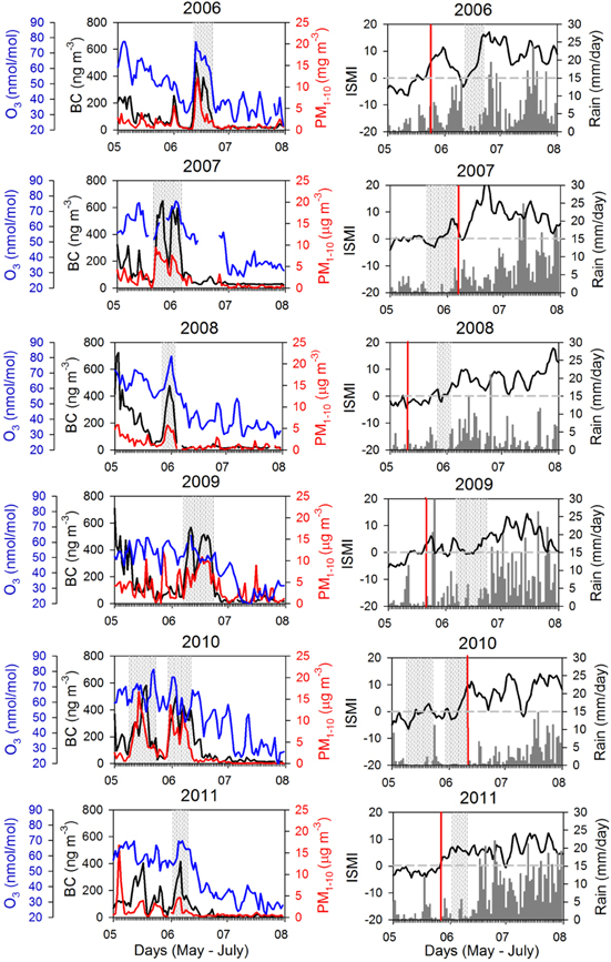
Figure 1. Left: daily mean values of O3 (blue), eqBC (black), and PM1–10 (red) at the NCO-P for May–July 2006–2011. Right: daily mean precipitation along the Khumbu Valley (gray bars), together with the daily ISMI index value (thick line). Shaded areas denote the event duration, and vertical red lines indicate the onset dates of the summer monsoon season at the NCO-P, based on Bonasoni et al (2010).
Download figure:
Standard image High-resolution image3. Results
During all of the analyzed monsoon onset periods, 'acute pollution' events were systematically identified at the NCO-P (table 1). Overall, seven events were identified, one for each of the six monsoon seasons, except for the 2010 monsoon, for which we detected two events (table 1). We considered an 'acute pollution' event to be a long-lasting period (at least 1 week) characterized by eqBC exceeding the typical value for background conditions at the NCO-P (100 ng m−3), as indicated by Marinoni et al (2010). These events had time durations ranging from 7 days (year 2008) to 17 days (year 2009), indicating that the central Himalayas can be affected by the transport of air masses rich in SLCF/P for a notable fraction of the monsoon onset period. Indeed, during the totality of the detected events, significantly higher (95% confidence level) O3, BC, and PM1–10 were observed at the NCO-P in comparison with the corresponding average summer monsoon values (figure 2). Considering all the detected events, on average surface O3, BC, and PM10 increased by +66%, +355%, and +414% when compared with the average summer monsoon values. The strongest pollution event day was observed on May 26, 2007, for eqBC (with daily mean value equal to 651 ng m−3), whereas for PM11–10 a record value of 21 μg m−3 was observed on June 16, 2009. The highest daily O3 was observed on May 22, 2010 (81.5 nmol mol−1). The statistically significant linear correlation between O3 and eqBC (R: 0.63, N = 516) as well as between O3 and PM1–10 (R: 0.68, N = 516) suggested that common processes could play a role in determining the behavior of these SLCF/P during the identified events.

Figure 2. Average mean values of O3 (left), eqBC (center), and PM1–10 (right) observed at the NCO-P during the seven detected events listed in table 1 (gray bars) and for each of the six monsoon seasons considered in this work (black bars). The vertical bars denote the expanded uncertainty of the mean (u) calculated as  (p < 0.05 with K = 2, where N is the number of data and σ the standard deviation).
Download figure:
Standard image High-resolution imageOver the course of four years (2006, 2008, 2009, and 2010), the events were observed during the early period of the summer monsoon season, whereas in two other years (2007 and 2011), they were observed several days before the calculated monsoon season onset (figure 1). The analysis of daily mean precipitation along the Khumbu Valley (figure 1) pointed out that the detected events systematically occurred when very little or almost no precipitation was recorded. Thus, we suspected that atmospheric conditions that were significantly different from those usually observed during the monsoon season would have played an important role in favoring the transport of SLCF/P to the Himalayas.
We analyzed the regional distribution of precipitation (TRMM), absorbing aerosol (OMI AI), and air-mass circulation (by means of LAGRANTO back-trajectory number field concentration) with the aim of better investigating any possible source region and atmospheric transport patterns that favored the occurrence of these large SLCF/P amounts in the Himalayas. For each parameter and for each detected event, we calculated the average spatial composites over South Asia during the event, and we did the same on the 7 days before and after the event. This made it possible to capture the synoptic-scale variability of rain precipitation, absorbing aerosol, and atmospheric circulation over the region of interest. The average of spatial fields over the years 2006–2011 is shown in figure 3. Before and during the events detected at the NCO-P and as deduced by TRMM data, no rainfall was present over the entire Ganges Valley, a strong source of anthropogenic pollution (see Ramanathan et al 2007). Dry conditions also characterized the region coinciding with the Thar Desert (28°–32° N; 72°–75° E), where large amounts of absorbing (mineral dust) aerosol were present as indicated by the high OMI AI value. Of interest is that whereas during the day (before or after the events) these large amounts of absorbing aerosol were confined mostly to the Thar Desert areas (western India/Pakistan), during the detected events high OMI AI values would stretch over the northwestern Indo-Gangetic plains and along the southern border of the Himalayan arc. This finding is in agreement with Shrestha and Barros (2010), who indicated the possibility that just before the onset of the summer monsoon rainy season, atmospheric conditions favor large amounts of absorbing aerosol buildup along the Himalayan foothills and their subsequent westward transport across the Indo-Gangetic plains. Moreover, Lau and Kim (2006) and Lau et al (2006) noted that carbonaceous aerosols deriving from biomass burning over northwestern India and Pakistan should significantly contribute to this aerosol hot spot. The presence of westerly circulation over the South Himalayas during the detected events is clearly explained by the LAGRANTO air-mass back-trajectories analysis calculated for the NCO-P. As reported in figure 3, during the detected events the geographical distribution of the points in the back trajectory is similar to the one observed during the pre-monsoon period ('prior event'), with an almost complete absence of air-mass circulation from the Bay of Bengal and central India, which is typical for summer monsoon circulation ('after event'; see also Bonasoni et al 2010). This fact supported the hypothesis that during the detected events, a change in atmospheric circulation at the NCO-P (and over the central Himalayas) occurred in respect to the typical summer monsoon conditions. This change favored (i) the transport of air masses that are richer in mineral dust, black carbon, and ozone from the Thar Desert and the northwestern Indo-Gangetic plains by westerly circulation and (ii) a weakening of wet scavenging due to the lack of rain precipitation over the Himalayas and the Indo-Gangetic plains (as shown by TRMM data). As indicated by previous studies (e.g., Zhou et al 2008), the SASM evolution could have had great impact on the Himalayan atmospheric system through changes in large-scale circulation. Indeed, the ISMI analysis pointed out that, during the first days of these events, a weakening or break stage of the southerly large-scale monsoon flow predominated over South Asia (negative or only slightly positive ISMI values were found). In this context, only the year 2011 appears to deviate from this general rule because the 'pollution' event was observed in concomitance with positive ISMI values. Shrestha et al (2000) reported that the behavior of the summer monsoon over Nepal is not completely in line with that over the Indian subcontinent. Thus, it is possible that for this case the SASM system over Nepal could have deviated from the rest of the Indian region.

Figure 3. Average spatial distribution (2006–2011) of rain from the TRMM, UV Aerosol Index (AI) from OMI and LAGRANTO back-trajectory points n(i,j) (see section 2 for definition) with altitude lower than 2000 m a.g.l., during the detected events (middle column) as well as during the 7 days before (left column) and after (right column) the detected events.
Download figure:
Standard image High-resolution imageWe calculated the conditional probability P(i, j) for the considered spatial domain (figure 4) with the purpose of specifically investigating the potential source regions of the SLCF/P that affected the NCO-P during the identified events. The map of potential sources pointed out possible significant contributions from the arid regions between Pakistan and Afghanistan, as well as Pakistan and northern India (e.g., Thar Desert). This appeared to be in agreement with Hyvärinen et al 2011a, 2011b) who indicated that aerosol concentrations during early monsoon can be affected by dust events from the Thar Desert at Mukteshwar (Indian Himalayas, 2180 m a.s.l.). High P(i,j) values were also registered for the northern Indo-Gangetic plains, suggesting that emissions occurring within the PBL of these regions could have contributed to the high O3, PM1–10, and BC values observed at the NCO-P. As revealed by the analysis of the OMI measurements, during the detected events, the northern Indo-Gangetic plain along the Himalayan ridge was a hot-spot region in terms of tropospheric amounts of NO2; this evidence supported the possibility that photochemical O3 production could occur in air masses transported from this region.

Figure 4. For the detected 'acute pollution events': (left) average spatial distribution of conditional probability P(i,j) of potential sources reconstructed using LAGRANTO back trajectories; (center) average spatial distribution of the South Asian tropospheric NOx amount from OMI; (right) average spatial distribution of the number of fires detected by MODIS. For each of the three maps, the colored bars report the respective value of each parameter considered.
Download figure:
Standard image High-resolution image
Because the northern Indo-Gangetic plains and the Himalayan foothills are a well-known hot spot in terms of the occurrence of open fires (e.g., Putero et al 2014, Vadrevu et al 2012), we studied the possibility that vegetation fires, both related to agriculture practices and forest fires, could influence the occurrence of high BC and O3 values at the NCO-P for the detected events. To this end, we analyzed the spatial and temporal distribution of the MODIS fires. As reported in figure 4, a large number of fires (calculated over a spatial resolution of 0.5° × 0.5°) characterized the western Himalayan foothills. In particular, the bulk of open biomass burning was evident in a geographical region between 72° and 75° E and between 30° and 33° N, which corresponded to northeastern Pakistan, a region characterized by high OMI Aerosol Index values (figure 3). We analyzed the occurrence of fires from MODIS together with the 5-day LAGRANTO back-trajectory ensembles in agreement with the methodology by Putero et al (2014) to provide an estimate of the impact that these open fires could have in influencing SLCF/P variability at the NCO-P; the measurement periods at the NCO-P were tagged as possibly affected by open-fire emissions in the case that the air-mass trajectory intercepted an active fire location. This analysis led to the conclusion that, depending on the year (see table 1), 9% to 43% of the measurement periods during the detected events appeared to be possibly affected by open-fire emissions. During this measurement subset, the average values of O3, eqBC, and PM1−10 were 64.8 ± 7.90 nmol mol−1 (mean value ± expanded uncertainty with p < 0.05), 464 ± 42 ng m3, and 7.1 ± 1.0 μg m−3. For each single event, higher SLCF/P values (see ΔO3, ΔBC, and ΔPM1–10 in table 1) were usually observed in respect to the average mean value during the remaining part of the detected events. Only with O3 did two events show negative ΔO3 values. However, O3 production from emissions from open burning biomass is a very complex process that is affected by several variables, e.g., fire emissions, chemical and photochemical reactions, aerosol effects on chemistry, and radiation (see Jaffe and Wigder 2012). This justifies the presence of a number of different increases (or even decreases) in ozone mixing ratios within smoke plumes.
4. Conclusion
Six years of continuous aerosol and trace gas observations from the GAW/WMO global station NCO-P show that large amounts of dust and anthropogenic pollutants, i.e., black carbon and ozone, can persistently reach the high Himalayas during the summer monsoon onset period (May–June). By considering the seven detected events, the following average mean values were observed: 62.8 ± 5.2 nmol mol−1 for O3 (mean ± 1σ), 344 ± 50 ng m−3 for eqBC, and 5.5 ± 1.7 μg m−3 for PM1–10. These values are comparable with the O3 observed during typical pre-monsoon 'acute pollution events' (see Marinoni et al 2013) but they represent 50% of the typical 'polluted' pre-monsoon eqBC and PM1−10 levels observed at the NCO-P (see Marinoni et al 2010, 2013). The monsoon events occurred during periods characterized by low (or nearly absent) rain precipitation in the high central Himalayas and appeared to be related to large-scale westerly flows that replaced the southerly circulation usually characterizing the central Himalayas during the summer monsoon. The westerly flow case is usually related to a weakening stage of the summer Asian monsoon system that, for some specific events (i.e., 2006, 2008, 2009), has had the features of monsoon 'break' events (see Hedge et al 2007, Zhou et al 2008). As deduced by the combined analysis of the spatial pattern variability of aerosol data from the OMI Aerosol Index, rainfall data from the TRMM, and atmospheric circulation by LAGRANTO back trajectories, the high amount of mineral dust, black carbon, and surface ozone reaching the NCO-P appeared to be related to emissions occurring within the PBL of central Pakistan (i.e., Thar Desert) and the northwestern Indo-Gangetic plain and Himalayan foothills, whereas open burning biomass did not have a completely negligible role. The systematic occurrence of these events during the summer monsoon onset period appeared to represent the most important source of SLCF/P inputs into the high central Himalayas during this season, with possible important implications for the regional climate and for hydrological cycles. Once transported to the high Himalayas, as clearly deduced by NCO-P observations, these SLCF/P are also likely to reach perennial snow. Here absorbing aerosol can have multiple climatic effects by absorbing solar radiation, increasing ambient atmosphere temperature, and darkening the albedo of snow and ice and thus modifying their spatial coverage (e.g., Ming et al 2002, 2008, Flanner et al 2009, Gautam et al 2009, Yasunari et al 2010, Qian et al 2011). Moreover, given that Gautam et al (2009) and Bollasina et al (2008) have suggested the existence of a link between seasonally increased atmospheric aerosol loading over the Indo-Gangetic plains and the initial active phase of the summer monsoon, a change in the frequency or in the duration of the acute events investigated here can bring about further regional climate alterations.
Acknowledgments
This work was supported by the Ev-K2-CNR SHARE Project and by the DTA-CNR/MIUR Project NextData. OMI-AI, tropospheric NO2, and TRMM data were provided by the Giovanni online data system, which was developed and is maintained by the NASA GES DISC. LAGRANTO back trajectories were provided by M Sprenger (ETH-Z). The authors would like to thank the Nepali team that has been working at the NCO-P GAW/WMO global station. The scientific activities at the NCO-P were made possible thanks to collaboration with the Nepal Academy of Science and Technology (NAST).