
Abstract
Loss of grassland from conversion to agriculture threatens water quality and other valuable ecosystem services. Here we estimate how land-use change affects the probability of groundwater contamination by nitrate in private drinking water wells. We find that conversion of grassland to agriculture from 2007 to 2012 in Southeastern Minnesota is expected to increase the future number of wells exceeding 10 ppm nitrate-nitrogen by 45% (from 888 to 1292 wells). We link outputs of the groundwater well contamination model to cost estimates for well remediation, well replacement, and avoidance behaviors to estimate the potential economic value lost due to nitrate contamination from observed land-use change. We estimate $0.7–12 million in costs (present values over a 20 year horizon) to address the increased risk of nitrate contamination of private wells. Our study demonstrates how biophysical models and economic valuation can be integrated to estimate the welfare consequences of land-use change.
Export citation and abstract BibTeX RIS

Content from this work may be used under the terms of the Creative Commons Attribution 3.0 licence. Any further distribution of this work must maintain attribution to the author(s) and the title of the work, journal citation and DOI.
1. Introduction
Largely due to rising commodity prices, grass-dominated land covers are being converted to annual row crops such as corn and soybeans across the Midwestern US (Johnston 2013, Wright and Wimberly 2013). The consequences of cropland expansion include declines in habitat for game and non-game wildlife, declines in soil carbon storage, and increased risk of soil erosion (Euliss et al 2010, Stephens et al 2008, Culman et al 2010, Smith and Searchinger 2012, Faber et al 2012). Grassland conversion to row-crop agricultural can also negatively affect water quality through the increased export of nutrients, sediment, and other agricultural chemicals (Donner and Kucharik 2008, Secchi et al 2011, Wu and Liu 2012). These changes in water quality may affect multiple water quality-related ecosystem goods and services including recreation value, property values, human health, and other aspects of wellbeing (Keeler et al 2012).
Tracing the links between land-use change, changes in water quality, and impacts on human wellbeing requires integrating biophysical models sensitive to land use change with economic approaches that assess the welfare consequences of changing levels of valued goods and services. The results of such integrated modeling provide evidence of the welfare consequences of environmental change, which is in high demand to support policy evaluation and decision-making (Griffiths et al 2012). The links between pollutants such as nitrate and negative effects on human wellbeing are assumed, but difficult to quantify (Dodds et al 2008, Compton et al 2011).
In this study, we analyze the impact of land-use change on water quality in eleven counties in Southeastern Minnesota (SE MN), a region with high rates of observed grassland conversion to agriculture. While there are many ecosystem services that are directly or indirectly affected by changes in water quality (Keeler et al 2012), we focus on the contamination of private drinking water wells by nitrate because it is assumed to be sensitive to land-use change and poses a threat to human wellbeing. The study region is characterized by high hydrologic connectivity between surface and groundwater due to the karst features that occur throughout SE MN (Alexander and Lively 1995, Tipping et al 2001). Statewide groundwater vulnerability maps rank much of the region in the 'high' or 'highest' vulnerability classification to contamination (Porcher 1989). The eleven counties that make up SE MN have a population of over 700 000, the majority of whom rely on groundwater as their primary drinking water source (MPCA, Minnesota Pollution Control Agency 2013).
We focus our analysis on nitrate because it is one of the most widespread contaminants in groundwater systems and one of the primary components of fertilizer applied to croplands (MPCA, Minnesota Pollution Control Agency 2013, Nolan et al 2002). Nitrate is highly soluble and mobile in soil, which facilitates leaching into surface and subsurface pathways (Vitousek et al 1997, Tomer et al 2010). Nitrate contamination also represents a public health concern. The US Environmental Protection Agency has set a maximum contaminant level (MCL) of 10 mg L−1 (10 ppm) nitrate-nitrogen due to concerns over the link between consumption of high levels of nitrate and methemoglobinemia or Blue Baby Syndrome (Spalding and Exner 1993). Exposure to levels of nitrate below the federal drinking water standard (2.5 to 5.5 mg L−1 nitrate-N) has also been associated with increased risks of some cancers, birth defects, and spontaneous abortions (Weyer et al 2008, Ward et al 2000, Ward et al 1996, Brender et al 2013).
Previous studies on groundwater well contamination by nitrate have focused on screening for significant predictors of groundwater sensitivity to nitrate pollution (Burow et al 2010), developing statistical models that link groundwater well contamination to well characteristics, nitrate sources, and transport and attenuation factors (Nolan et al 2002, Wick et al 2012, Nolan and Hitt 2006, Lichtenberg and Shapiro 1997, Mair and El-Kadi 2013, Carbó et al 2009), or studying consumer response to nitrate contamination and associated costs (Lewandowski 2008). Our study builds on previous work linking land-cover specific nitrate load to subsurface well contamination. However, we link our biophysical assessment with surveyed behavior and cost data for an integrated study of land-use change impacts on groundwater contamination and economic value. There is increasing demand for this kind of integrated assessment in order to evaluate the benefits of regulations such as the Clean Water Act, to efficiently target conservation and restoration resources, to effectively design incentive or payment for ecosystem services schemes, and to understand the full external costs of land-use change (Daily et al 2009, Iovanna and Griffiths 2006, Kinzig et al 2011, Tallis and Polasky 2009).
This paper addresses four questions related to assessing the water quality consequences of land-use change: (1) what biophysical and hydro-geologic factors identify groundwater wells that are susceptible to contamination due to land use and land-use change? (2) for these susceptible or 'at-risk' wells, what is the relationship between surface nitrate loading and groundwater nitrate contamination? (3) based on the modeled relationship between well contamination, surface nitrate loading and other variables, how many groundwater wells are likely to be at increased risk of contamination due to land-use change? (4) what are the societal costs associated with these predicted changes to groundwater quality?
2. Methods
Our objective was to estimate nitrate contamination and associated costs for all recorded private drinking water wells in SE MN. However, well nitrate data were only available for a subset (less than 30% of wells in the public record). Therefore, we first explored the relationship between well contamination by nitrate and likely explanatory variables affecting the source, transport, and attenuation of nitrate for a subset of wells with recent chemistry data and other known attributes (1777 wells). We used this relationship to create a model that estimates the probability of well contamination as a function of observed attributes. We then applied this model to all wells with spatial location information to estimate the expected number of contaminated wells under a baseline and cropland expansion scenario (15 107 wells). Finally, costs associated with well contamination were applied to estimates of the number of wells at future risk of contamination to value the total cost of nitrate pollution of drinking wells due to land-use change. More details on statistical methods, variable screening, and model parameterization are described in the online supplemental materials available at stacks.iop.org/ERL/9/074002/mmedia.
2.1. Well dataset
The Minnesota Department of Health and the Minnesota Geologic Survey maintain the County Well Index (CWI), a spatially-explicit database of geologic and construction information from well logs for reported wells drilled in Minnesota since 1974. In the eleven county study region, there are 22 516 CWI wells with location information (located wells) and 16 126 wells without location information (unlocated wells) for a total of 38 642 wells. In order to assess the influence of surface nutrient loading associated with recent land use in the region we narrowed the subset of wells to those with chemistry readings recorded from 2006 to 2012. Previous studies linking land use and groundwater nitrate concentrations have found lag times of years to decades for the effects of land-use change to influence groundwater nitrate (Shilling and Spooner 2006, Tomer et al 2010). For this reason, we include well chemistry data through the most recently recorded sampling dates (2012) and compare these readings to a baseline land use map for 2007 (NLCD Cropland Data Layer).
The spatial distribution of wells with nitrate data and the location of all CWI wells with location data are shown in figure 1. We calculated the maximum concentration of nitrate recorded over the seven year period for each well. We selected the maximum value (as opposed to the mean concentration) because the federal standard for MCL for nitrate of 10 mg L−1 (as nitrogen) represents the highest level allowed in drinking water. The MCL for nitrate is a legally-enforceable standard for public water suppliers regulated by the EPA. Private well owners are not required to abide by these MCL standards, but we make the assumption that well owners will treat or avoid water that violates federal guidelines.
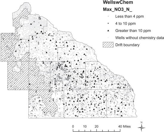
Figure 1. Spatial location of wells with known location information and wells with recent chemistry data. The shaded polygon represents the eastern boundary of glacial drift deposits where the depth to bedrock is greater than 50 ft. Parameter screening approaches identified the drift boundary as a significant feature in classifying contaminated and uncontaminated wells (see SI). As a result, we excluded wells from the final model that were within the drift boundary assuming that these wells were buffered from nitrate contamination by the thick layer of unconsolidated material.
Download figure:
Standard image High-resolution image2.2. Model form and estimation
We assembled spatial data on soil characteristics, surficial and bedrock geology, well attributes, and estimated surface nitrate load (within a 500 m radius) for each well based on a literature review of important nitrate transport and attenuation factors (online supplemental materials, table S1). We evaluated multiple logistic regression models based on all candidate explanatory variables using backwards stepwise regression and cross-validation approaches in order to identify factors that best predicted observed well nitrate contamination. We applied the parameterized multiple logistic regression models to predict the probability of exceeding two specified nitrate concentrations. We used a threshold of 10 mg nitrate-NL−1 (10 ppm) to represent the maximum contaminant standard set by the US Environmental Protection Agency (US EPA 2011) and a threshold of 4 mg nitrate-NL−1 (4 ppm) because exposure at or near to this level has been linked to birth defects and increased risks of some cancers (Weyer et al 2008, Ward et al 2000, Brender et al 2013). We tested the fully-specified model for evidence of spatial autocorrelation by plotting model residuals and estimating global Moran's I statistics in ArcGIS, but found no evidence for significant spatial autocorrelation (z = 1.51, p = 0.12).
We applied the resulting model to each of two scenarios. For the baseline land-use scenario we used the 2007 Cropland Data Layer, a 56 meter resolution raster reclassified into fifteen land cover types (USDA NASS). To represent an 'agricultural expansion' scenario we used the 2012 Cropland Data Layer for the same region. The 2012 map reflects a 26% net loss in grass-dominated cover from the baseline 2007 landscape for this study region. As grassland cover declined, corn and soybean acreage increased by 27% over the same period. These trends are similar to those observed in recent analyses of land cover change in the Midwest which have shown rapid and widespread loss of grasslands to row crop expansion (Johnston 2013, Wright and Wimberly 2013).
These land-use maps were used to estimate the changes in surface nitrate load surrounding each located well. We assigned an export coefficient representing the average annual load of nitrate (in kg nitrate-N ha−1 yr−1) to each land cover type (e.g. forest, grassland, corn) based on literature values (online supplemental materials, table S2). These export coefficients are based on empirical studies with values derived from national meta-analyses, field trials, or experimental plots. For the agricultural covers, we applied export coefficients from studies in Minnesota and neighboring states to best control for variation in atmospheric nitrogen deposition, precipitation regimes, and management practices that may affect nitrate export (see online supplemental materials, table S2). The estimated nitrate load maps corresponding to each land-use scenario are shown in figure 2, where the conversion of grassland to agriculture is visible as a net increase in nitrate load across the landscape. The nitrate export maps are not intended to represent the nitrate exported in the specified years (2007 or 2012), but rather annual average export for landscapes represented by the land-use trends illustrated in these maps.
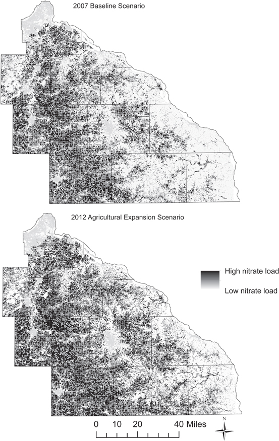
Figure 2. Map of southeast Minnesota showing estimated nitrate load based on land use for a 2007 baseline and 2012 agricultural expansion scenario. Each land cover type was assigned a nitrate load coefficient based on literature values. The effect of grassland conversion to agriculture can be seen as an increase in the amount of high nitrate pixels in the agricultural expansion map. These raster layers were used to assign an estimated nitrate load value to each located well in our study set under each scenario.
Download figure:
Standard image High-resolution image3. Results
3.1. Predictors of nitrate well contamination
The significant predictors of groundwater well nitrate concentration were surface load of nitrate, percent clay, mean drainage class, and aquifer rank for each well (defined as the number of geologic formations overlying the tapped aquifer, see SI). There was agreement in explanatory variables across the two contamination thresholds, with the only exception being percent organic matter, which was significant for only the 4 ppm threshold model (table 1).
Table 1. Parameter estimates and significance tests for the 4 ppm and 10 ppm logistic regression models.
| Effect likelihood ratio tests | ||||
|---|---|---|---|---|
| Estimate | Standard error | Logistic regression chisquare | Prob > chisquare | |
| 4 ppm response variable where 1 = threshold exceeded | ||||
| Intercept | −7.000 | 0.835 | ||
| Sum of the surface load of nitrate-N around each well (kg nitrate-N ha−1 yr−1) | 0.0003 | 3.59e-5 | 51.43 | <0.0001 |
| Average percent clay in well recharge zone | 0.086 | 0.018 | 24.23 | <0.0001 |
| Average percent organic matter in well recharge zone | −0.577 | 0.205 | 11.52 | 0.0050 |
| Average drainage class in well recharge zone | 0.987 | 0.134 | 64.94 | <0.0001 |
| Aquifer rank below the uppermost bedrock unit | −0.810 | 0.073 | 151.18 | <0.0001 |
| 10 ppm response variable where 1 = threshold exceeded | ||||
| Intercept | −14.538 | 1.409 | ||
| Sum of the surface load of nitrate-N around each well (kg nitrate-N ha−1 yr−1) | 0.003 | 0.00005 | 46.14 | <0.0001 |
| Average percent clay in well recharge zone | 0.166 | 0.031 | 35.10 | <0.0001 |
| Average percent organic matter in well recharge zone | ns | ns | ns | ns |
| Average drainage class in well recharge zone | 1.845 | 0.229 | 98.80 | <0.0001 |
| Aquifer rank below the uppermost bedrock unit | −1.103 | 0.126 | 107.39 | <0.0001 |
The significance of surface nitrate load in predicting groundwater contamination indicates that wells in the subset are sensitive to changes in surface nitrate loading and thereby sensitive to changes in land use and land management in the region. Wells with higher estimated surface loads had higher nitrate concentrations and greater probabilities of exceeding well contamination thresholds. Another way to interpret the effect of an explanatory variable using logistic regression is through odds ratios or  where p is the probability of exceeding the threshold value of 4 ppm or 10 ppm. The range odds ratio for surface nitrate load indicates that as nitrate load increases from the lowest recorded level to the highest recorded level, wells are 18 times more likely to exceed 4 ppm nitrate or 46 times more likely to exceed a 10 ppm nitrate threshold (table 2).
Table 2. The range odds ratios for the explanatory variable surface nitrate load with 95% confidence intervals in parenthesis.
| Range odds ratios 4 ppm | Range odds ratios 10 ppm | |
|---|---|---|
| Sum of the surface load of nitrate-N around each well (kg nitrate-N ha−1 yr−1) | 17.5 | 45.8 |
| (8.0–38.4) | (15.4–138.8) |
3.2. Application of the model to wells without chemistry data
To answer the question of how well contamination may respond to observed changes in land use we applied the logistic regression model to 15 107 wells in the eleven county region with location information. Using the logistic regression models estimated for the sub-set of wells with chemistry data, we evaluated potential well contamination for this larger set of wells under baseline and agricultural expansion scenarios. Under the baseline scenario, 888 (6%) of groundwater wells were estimated to exceed a 10 ppm nitrate threshold and 2779 (18%) to exceed a 4 ppm nitrate threshold (table 3). Under the 2012 agricultural expansion scenario, the model estimated 3562 wells at-risk of exceeding the 4 ppm threshold (a 28% increase) and 1292 wells at-risk of exceeding the 10 ppm threshold (a 45% increase; table 3, figure 2).
Table 3. Estimated number of wells exceeding each contamination threshold for the subset of wells with chemistry data (training set) and the full set of located wells under the baseline and agricultural expansion scenario. Percent of wells in each category relative to all wells are in parentheses.
| Training set under the baseline scenario | 2007 Baseline scenario | 2012 Agricultural expansion scenario | Increase in the number of wells predicted to be at risk of contamination due to land-use change | |
|---|---|---|---|---|
| Estimated number of wells exceeding 4 ppm | 245 (14%) | 2779 (18%) | 3562 (24%) | 783 |
| Estimated number of wells exceeding 10 ppm | 94 (5%) | 888 (6%) | 1292 (9%) | 404 |
| Total number of wells | 1777 | 15 107 | 15 107 |
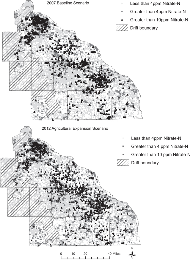
The agricultural expansion scenario should not be interpreted as an estimate of well contamination in the year 2012, but rather an estimate of potential future contamination attributable to the land use change trends observed in this region (figure 3). The residence time and flow path of water as it moves vertically from the surface to each well cannot be estimated from available data. As a result, the land-use observed in 2012 may not be reflected in well contamination in the same year (Schilling and Spooner 2006, Tomer et al 2010). We limited the dataset to focus on those wells where it is reasonable to assume that there is exchange between surface and groundwater over shorter time periods (months to years). However, the effects of nitrate contamination at the surface may persist for years or even decades later (Tomer and Burkart 2003, Sebilo et al 2013).
Figure 3. Model estimated risk to groundwater well contamination under the baseline and agricultural expansion scenarios.
Download figure:
Standard image High-resolution image
3.3. Costs of predicted well contamination
The costs of groundwater nitrate contamination include the costs of remediation actions taken to either replace a contaminated well, install a filtration system or other treatment technologies, or the costs of avoidance behaviors such as purchasing bottled water for drinking and cooking (Lewandowski 2008, table 4). If water is untreated and consumed then there may be costs related to health impacts from drinking untreated water with elevated nitrate (Townsend et al 2003). Here we focus on the costs associated with treating, replacing, or avoiding contaminated well water. Table 4 summarizes the costs of nitrate treatment technologies, new well construction, and drinking bottled water to avoid exposure to elevated nitrate in well water.
Table 4. Per household costs of responses to groundwater well contamination by nitrate. Low and high cost estimates are based on reported costs in Lewandowski (2008), Mahler et al (2007) and estimates from regional well drillers. Bottled water costs assume two gallons daily per capita water consumption for a 2.2 person household at $0.33–0.70 per gallon (low, high bottled water cost estimates, respectively). Present value costs assume a 3% rate of discount over a 20 year time horizon.
| Initial costs | Annual costs | Present value | |
|---|---|---|---|
| Reverse osmosis | $300–1700 | $100–300 | $1790–6160 |
| Distillation | $250–1500 | $400–500 | $6200–8940 |
| Anion exchange | $600–2200 | $270–470 | $4620–9190 |
| New well | $7200–16 000 | — | |
| Bottled water | — | $530–1590 | $7880–16 725 |
We estimate costs using two different approaches. First, we assume that all households will treat using the least-cost approach of installing a reverse-osmosis treatment system. We calculated the present value of costs for treating all of the additional wells exceeding 10 ppm due to land-use change over the twenty year time horizon to be $1.4–4.8 million and $0.7–2.5 million for treating all additional wells exceeding 4 ppm (table 5). This approach represents the lowest cost solution that ensures all households are protected from the health impacts of high nitrate. However, the assumption of 100% adoption of a low-cost technology by households is not supported by the results of a 2008 study in Minnesota that surveyed residents for actions taken if they perceived well contamination by nitrate (Lewandowski 2008). The survey was conducted in conjunction with well nitrate testing so hypothetical responses to contamination could be compared to actual responses taken by owners with confirmed cases of nitrate contamination. In the second cost estimate we apply costs associated with the observed adoption rates reported by surveyed owners of contaminated wells reported in Lewandowski (2008).
Table 5. Costs associated with the modeled increase in future well contamination due to land-use change. Adoption rates are from actual responses to well contamination in Minnesota from Lewandowski (2008). Least cost estimates assume all households respond to nitrate contamination by adopting the least-cost approach (reverse osmosis treatment). Present value costs are based on a 20 year time horizon assuming a 3% rate of discount applied to best estimate costs (high and low) for each potential response. Total costs are the present value estimates applied to the number of additional predicted contaminated wells under the agricultural expansion scenario for each of the two contamination thresholds.
| Adoption rate | Present value of costs per well (20 year time horizon) | Total costs due to land-use change for a 4 ppm threshold (783 wells) | Total costs due to land-use change for a 10 ppm threshold (404 wells) | |
|---|---|---|---|---|
| Nitrate treatment (weighted by adoption rates for each of the three technologies in table 4) | 21.9% | $2600–6710 | $444 900–11 47 400 | $229 000–590 500 |
| New well | 25% | $7200–16 000 | $14 11 200–31 36 000 | $727 200–16 16 000 |
| Bottled water | 25% | $7880–16 725 | $15 45 500–32 78 200 | $796 400–16 89 300 |
| Do nothing | 37.5% | — | — | — |
| Total costs based on actual responses | $34 01 600–75 61 600 | $17 52 600–38 95 700 | ||
| Total costs assuming least-cost response | 100% | $1790–6160 | $13 99 800–48 25 800 | $722 300–24 90 000 |
Costs rise significantly using the actual behavioral responses as reported in Lewandowski (2008) even though only 62.5% of households reported taking any action to avoid contamination. We estimated the twenty year cost of increased well contamination to be $1.8–3.9 million based on a 10 ppm treatment threshold and $3.4–7.6 million for 4 ppm (table 5). There may be other motivating factors besides cost that influence a household decision to adopt a particular response as evident from the range of observed responses to nitrate contamination documented in Lewandowski (2008). This estimate does not include costs associated with drinking water with elevated levels of nitrate for the 37.5% of households that do nothing and may suffer negative health consequences as a result. If we assume that the potential health costs of doing nothing are at least as great as the costs associated with the lowest cost treatment, then our total cost estimates increase to $2.0–4.8 million for a 10 ppm threshold and $3.9–9.4 million for a 4 ppm threshold. Assuming non-zero health costs for households that do nothing in response to contamination, the cost estimates reported in table 5 are conservative and represent an underestimate of the true cost.
Many wells in the region were excluded from the analysis because they were not in the well record, lacked specific location information (16 126 wells), or were missing data on explanatory variables (an additional 4661 wells). Assuming these wells followed the same percentages of contamination under both scenarios as observed for wells with location and attribute data, the total costs attributable to land-use change would more than double to $2.7–6.0 million for a 10 ppm threshold and 5.4–12.0 million for a 4 ppm threshold (assuming adoption rates based on actual surveyed responses). There are an unknown number of wells that are not listed in the CWI and therefore not accounted for in our estimates. These wells are likely to be older wells, built before 1970 when stricter well codes were enacted in Minnesota. These wells are likely to have higher rates of nitrate contamination because they tend to be shallower with poorer construction (Lewandowski 2008).
4. Discussion
The results of the logistic regression models for well contamination are consistent with previous studies that found a significant positive relationship between shallow aquifer concentrations of nitrate and land use in estimated recharge zones around wells (Lichtenberg & Shapiro 1997, Tesoriero and Voss 1997, Nolan et al 2002, Gardner and Vogel 2005, Liu et al 2005, Nolan and Hitt 2006, Gurdak and Qi 2012, Wick et al 2012, Mair and El-Kadi 2013).
Tests for model fit and predictability indicated good model performance (see online supplemental materials) but also highlight the challenges associated with predicting groundwater well contamination. In the absence of detailed information on subsurface geology, groundwater flow and transport models, spatially-explicit estimates of groundwater recharge, and information on aquifer volume and chemistry, it is difficult to accurately predict groundwater contamination over time and space. Factors considered in this study represent vertical transport pathways and processes that affect nitrate levels, but do not capture lateral movement of nitrate. Additionally, there are significant temporal lags in groundwater systems. It may take years or decades for the land-use related nitrogen inputs to affect groundwater nitrate concentrations in private wells (Tomer and Burkart 2003, Sebilo et al 2013). Despite these challenges, our study and previous work demonstrate that land use, particularly the extent of agriculture, is a significant driver of well nitrate contamination.
The high-end estimate of the present value of costs due to the estimated increase in nitrate contamination from agricultural expansion was $12 million dollars (assuming a 20 year time horizon). This estimate is conservative for several reasons. First, a large number of wells were excluded from the analysis due to data availability. Second, cost estimates do not include any health impacts associated with drinking untreated water for residents that are unaware of nitrate contamination or chose not to treat or avoid consuming contaminated water. Our estimates also assume that all households are aware of the nitrate contamination and respond accordingly. Previous surveys of nitrate contamination in groundwater wells showed that significant percentages of consumers are not aware of the nitrate levels in their wells. In the Minnesota survey of well owners, only 29% of respondents had tested their wells for nitrate within the last three years (Lewandowski 2008). A study of nitrate contamination in California drinking water found greater than 50% of surveyed residents in areas with high nitrate water were not aware that nitrate was the source of contamination. The same study found that exposure to high nitrate water was concentrated in areas with low awareness of the problem and greater numbers of low-income households with fewer financial resources to deal with water contamination (Moore et al 2011). Third, our cost estimates do not include reduced property values for homes with contaminated wells or costs incurred by livestock owners with contaminated wells. Fourth, we did not consider health impacts or treatment costs related to other agricultural pollutants in untreated private drinking water wells, but these contaminants may also pose significant health risks to rural residents (Gilliom 2007). Finally, surveys asking households their willingness to pay to avoid drinking water contamination have found significantly higher per household costs than the avoided treatment estimates presented here (Crutchfield et al 1997, Poe and Bishop 1999). This suggests the avoided costs only capture a portion of the full impacts to welfare associated with drinking water contamination.
5. Conclusion
This paper demonstrates the link between land-use change, water quality, and impacts on human well-being. We provide evidence that land-use change in a region experiencing rapid and extensive grassland loss is likely to significantly increase the number of contaminated private drinking water wells, demonstrating a tradeoff between a private gain (agricultural production) and degradation of a public good (groundwater quality). Our estimates of wells contamination are in addition to wells already contaminated due to baseline land-use change in this predominantly agricultural region.
The land-use trends we evaluated in SE MN are not unique. Recent analyses of land cover data across the Midwestern US have found evidence for rapid and extensive grassland conversion to row-crop agriculture (Johnston 2013, Wright and Wimberly 2013). Future land-use change models for the US, based on commodity prices and demand for bioenergy feedstocks, also predict that as the price of corn and other crops rise, additional land will be converted to agriculture (Mehaffey et al 2012, Secchi et al 2011, Lawler et al 2014). These land-use projections have stopped short of estimating the costs associated with degraded water quality. Our methodology could be applied to other scenarios and regions to assess the tradeoffs between agricultural expansion and intensification and costs to public goods such as clean water.
We find that private well owners across SE MN may be faced with millions in additional costs to treat or avoid nitrate contamination due to observed land-use change. While the costs associated with groundwater contamination maybe burdensome to households, the total costs of nitrate pollution are unlikely to exceed the value of crop production associated with agricultural expansion. Still, this study addresses a growing need to estimate the externalities associated with land-use and management decisions. Our approach can serve as a template for future interdisciplinary work where data is needed to inform cost benefit assessments, design water trading programs, or to target lands for investments in water quality protection.
Acknowledgements
We thank Robert Tipping and Tony Runkel of the Minnesota Geologic Survey for providing the well dataset, surficial and bedrock geology information, and assistance with representing the geologic context of the region. Martin Bezener provided assistance with statistical analysis. Jacques Finlay and Jason Hill provided comments that improved the manuscript. Terry Lee, Pat Sarafino, and Jeff Broberg provided information on nitrate-related costs.