

Abstract
The Mongolian Plateau hosts two different governments: the Mongolian People's Republic and the Inner Mongolia Autonomous Region, a provincial-level government of the People's Republic of China. The divergence between these governments has widened in the past century, mostly due to a series of institutional changes that generated different socioeconomic and demographic trajectories. Due to its high latitude and altitude, the Plateau has been highly sensitive to the rapid changes in global and regional climates that have altered the spatial and temporal distributions of energy and water. Based on a recent workshop to synthesize findings on the sustainability of the Plateau amidst socioeconomic and environmental change, we identify five critical issues facing the social-ecological systems (SES): (1) divergent and uncertain changes in social and ecological characteristics; (2) declining prevalence of nomadism; (3) consequences of rapid urbanization in transitional economies; (4) the unsustainability of large-scale afforestation efforts in the semi-arid and arid areas of Inner Mongolia; and (5) the role of institutional changes in shaping the SES on the Plateau. We emphasize that lessons learned in Inner Mongolia are valuable, but may not always apply to Mongolia. National land management policies and regulations have long-term effects on the sustainability of SES; climate change adaptation policies and practices must be tuned to local conditions and should be central to decision-making on natural resource management and socioeconomic development pathways.
Export citation and abstract BibTeX RIS
1. Social-ecological systems (SES) on the Mongolian plateau
The contingent, heterogeneous, and adaptive dynamics of ecological (Holling 1996) and socioeconomic systems (Rosser 1999) often yield complex behaviors in coupled SES, with emergent properties that defy reductionist approaches (Holling 2001, Walker et al 2002, Allen et al 2003, Ostrom and Cox 2010, Binder et al 2013, Chen et al 2015b, Turner et al 2016). Further complications arise from the disparate scales of observation used to study ecological and socioeconomic systems, making measurements at commensurate scales in space and time an exception rather than the rule. For example, data on crop and livestock production may be reported annually at the provincial level based on a survey of producers. In contrast, gross primary production may be measured annually at 1 km or finer resolution based on remote sensing data streams with a temporal resolution of twice-daily. Making linkages between biogeophysical variables retrieved from remote sensing and socioeconomic variables reported through administrative channels is fraught with uncertainties, missing and unreliable data, heterogeneity in measurement and modeling techniques, and mismatches of scale. Nevertheless, it is possible to use disciplinary understanding to identify relationships between socioeconomic and ecological processes that generate observable, expected patterns. These patterns then become the basis for evaluating differences among SES.
The Mongolian Plateau hosts a natural experiment of opportunity for investigating SES: a vast ecosystem used by pastoralists since 1300 BCE (John et al 2009, Fernández-Giménez et al 2017) that was subdivided in the early 20th century into two governments with different socioeconomic systems: the Inner Mongolia Autonomous Region (IM), a provincial-level government of China, and the country of Mongolia (MG). Over time, environmental policies, economic development and demographic pressures have progressed at different rates and intensities across the political border, resulting in quite different landscapes and social-ecological conditions. For instance, rapid land use con demographics and urbanization throughout much of IM and associated regulatory mechanisms (John et al 2009, Fernández-Giménez et al 2012) has resulted in much higher rates of land degradation compared to MG (Fernández-Giménez et al 2012, John et al 2013, Liu et al2013, Wang et al 2013, Dangal et al 2016). There are also marked differences in economic development (Wang et al 2013, Zhang et al 2017), human demographics and urbanization patterns (Fan et al 2016, Park et al 2017), livestock population trends, and agricultural development (Fernández-Giménez et al 2012, Qi et al 2017). Furthermore, there is a major ethnographic difference between IM and MG, where MG is an independent country (with ~96% of its population being ethnic Mongols) while IM is a part of China with ~80% of its population being Han Chinese. In both cases, we observe tendencies of growing urbanization. However, within-country migration to Ulaanbaatar is accompanied by the depopulation of rural areas, while in IM a strong influx of population from other Chinese provinces has compensated the rural (and, in particular, nomadic) population decline. These variations in socio-ecological parameters are compounded by spatiotemporal variation in climate (Liu et al 2013, John et al 2016, Groisman et al 2017), as well as interactive feedbacks among the elements of SES (Hardin 1968, Chen et al 2015b, Hao et al 2016a, Allington et al 2017, Hessl et al 2018).
Similar to other SES across the globe, the functions and dynamics of the SES on the Plateau are affected by multiple contingent drivers (Turner et al 2016) including population, economy, market globalization, global to regional climatic changes, and the emergence of online information exchange (Chen et al 2013, Groisman et al 2017, Allington et al 2018, Fan et al 2018a). Several major geopolitical shifts—e.g. the collapse of the former USSR, transition from a planned to a market-driven economy, and accession to the World Trade Organization (WTO)—have also played major roles in shaping the SES since 1980 in IM and since 1991 in MG (Chen et al 2015a). Specific institutional changes include the various policies proposed and implemented at the national level that may protect the environment, prevent natural disasters and attenuate natural disturbances (e.g. desertification, sands storms), and/or promote socioeconomic development—all of which are critical for the stability and sustainability of SES. For example, in IM, 'The Three-North Shelterbelt' and the 'Grain to Green' programs were implemented to restore degraded grasslands and to mitigate the impacts of local climatic change, desertification, and soil erosion. In MG, the 'Law on Lands (1994)' and the 'Law on Allocation of Land to Mongolian Citizens for Ownership (2002)' aimed to improve management and protection of land resources and to promote their 'rational use' (Fernández-Giménez and Batbuyan 2004, Fernández-Giménez et al 2008, Gao et al 2016). These national policies further exacerbate the different trajectories of the two SES, exhibiting different structures and functions, and differential vulnerabilities to disturbances (see specifics in section 2.5). From an institutional perspective, Chen et al (2015a) reported that the collapse of the USSR was the most important institutional shift of SES for MG; whereas, the accession of China into the WTO appeared to be the key event affecting SES development in IM. Despite this accumulated knowledge, there remain many questions about the short- and long-term sustainability of the SES, especially with the increasing pressures from new economic shifts (e.g. mining, resource extraction), land conversions, climate change, land use and shifts, and rural out-migration.
In June of 2017, 65 scholars gathered in Ulaanbaatar, MG for a workshop to synthesize recent scientific findings relevant to the understanding of the SES of the Plateau, as well as our prospects for the sustainability of the SES amidst socioeconomic and environmental changes. The 3 day workshop was organized to advance the development of new products, synthesizing data and expertise in human and nature systems. Each participant brought to the table their particular mix of skills, expertise, and data for collaboration. A call for synthesis topics was sent to all participants two months before the workshop. During the workshop, each participant gave a brief presentation, followed by three rounds of concurrent thematic discussion groups so that each participant had sufficient time and opportunity for input. Participants were encouraged to move between discussion groups. As expected, a long list of current challenges to understanding the future trajectories of the SES were identified and discussed (e.g. global and local environmental changes, dzuds, heatwaves, overgrazing, globalization, migration and remittances, etc). Here we summarize these challenges into five broad, critical issues that represent emerging processes that are key to understanding the SES on the Plateau. One, the divergence between IM and MG has led to observable changes in the relationships between ecological and socioeconomic indicators that reflect changes in SES development in recent years. Two, a marked contrast between IM and MG in terms of the prevalence of nomadic practices has emerged due to different sedentarization policies, market integration, improved transportation and communication, and the emergence of other economic sectors. Three, large-scale afforestation in the arid and semi-arid areas of IM is unsustainable. Four, sustainability challenges are being caused by rapid urbanization in both IM and MG due to shifts in land use and demographics. Five, myriad institutional changes arising from outside the Plateau have significant impacts on SES functions within the Plateau, including globalization (e.g. international trading, information via the Internet, labor migration, etc).
2. Five critical issues
2.1. Divergent and uncertain social-ecological systems
Climate, geomorphological setting, and soils jointly determine ecosystem type, structure, function and dynamics from local to global scales (Brown and Lomolino 1998), while the richness and accessibility of natural resources are the primary reasons for humans to select dwelling places (Diamond 1997). A common characteristic of any SES is that the spatiotemporal changes in social and ecological characteristics do not match, which creates additional challenges for studying SES when compared with investigations of those social systems or ecosystems independently (Chen et al 2015b, Turner et al 2016). On the Mongolian Plateau, however, widened mismatches have been found in the past century, arising mostly from several institutional changes that generated different socioeconomic and demographic trajectories in the two governments. For example, the political push to resettle Han Chinese into IM during 1950–1980 greatly elevated the population density and urban development while diluting the proportion of ethnic Mongols in IM (Park et al 2017). The Cold War between NATO nations and Warsaw Bloc nations led to an anomalously high population density in the remote Bayan-Olgii Aimag in western MG, where the USSR installed military bases (M, figure 1). After the formal collapse of the USSR in 1991, the majority of Bayan-Olgii's residents moved away to Russia, to cities in central Mongolia, or to other aimags with greater economic opportunities (Chen et al 2015b). These large-scale changes in human population distribution led to land cover/land use changes (e.g. new development of agricultural lands) that, in turn, affected ecosystem structure and function (e.g. species abundance and diversity, spatial distribution of ecosystem functions; see section 2.3 for an example of large scale afforestation in the Gobi Desert).

Figure 1. Long-term changes in (a) gross primary productivity (GPP, gC m−2 yr−1) (2000–2014), (b) evapotranspiration (ET, mm yr−1) (2001–2016), (c) livestock density (LSKd, unit km−2 yr−1), and (d) population density (POPd, No. km−2 yr−1) on the Mongolian Plateau. The linear trends of GPP and ET were based on the 1 km products of MODIS while those of POPd and LSKd were calculated at the province level (aimag in Mongolia and meng in Inner Mongolia) based on the government's annual statistics (1990–2017). IM and MG are separated by the thick black line.
Download figure:
Standard image High-resolution imageRapid climatic changes since the First World War have further caused dramatic changes in ecosystems and land use across the Plateau (Chen et al 2013, Groisman et al 2017, 2018). There has been an increase in the frequency of drier summers and colder winters on the Plateau in recent decades (John et al 2016, 2018), but the rates of change in climatic variables are not spatially homogeneous across the Plateau (John et al 2016). These uneven changes could alter the interactive feedbacks among the elements of SES (e.g. altered albedo-LAI relationship; Tian et al 2018) and, consequently, result in different structure and functions of ecosystems. Gross primary production (GPP) and evapotranspiration (ET), two key coupled ecosystem functions, are critically linked to regional natural resources, grass yield and water availability. These two variables have varied greatly across the Plateau in space and in time (figures 1(a) and (b), Chen et al 2015b, John et al 2018) during the past decades (Running et al 2004, Mu et al 2011). Liu et al (2014) reported that northern parts of the Plateau experienced stronger influence of warming on ecosystem production, whereas the southern parts of the Plateau witnessed stronger direct human impacts through land use change. Spatial variability in both key ecosystem indicators is apparent within each political entity, which have similar ecosystems but different socio-political regimes and land management practices, and divergent land cover/land use change trajectories. Altogether, the spatial distributions of historical natural ecosystems and human settings have been substantially altered in recent decades, making an understanding of the functioning of current and future SES in the Plateau more challenging.
A general inverse relationship between socioeconomic drivers and ecological elements is evident in several provinces of Mongolia. Nonparametric trend analysis has shown significant decreases in annual GPP and ET (figures 1(a) and (b)) in the northern provinces (A) (figure 1(a)) that include Mongolia's three major cities: Ulaanbaatar, Darkhan-Uul, and Erdenet. It is important to note that the detected trends are statistically significant changes in recent decades. These trends do not predict future dynamics, but rather indicate past changes. These decreases correspond to a period of rapid urban growth from 2000 to 2014 (Park et al 2017). Evidence for the growing urban footprint appears in the increasing trends of livestock density (LSKd) and human population density (POPd) and (figures 1(c) and (d)) in these northern provinces. The increased frequency of drought and dzuds (i.e. severe winters) in the last decade has led to a sharp increase in urbanization in the northern provinces (John et al 2013, Fan et al 2016, Groisman et al 2017). Significant decreases of GPP and ET in the north-central provinces of Khovsgol, Bulgan, and Selenge (B) exhibit concomitant increases in LSKd and POPd (figures 1(c) and (d)). Similarly, the south-central province of Uvurkhangaii (C) shows an increasing trend in GPP and a decreasing trend in LSKd. On the other hand, significant increasing trends in GPP and ET in the peripheral, eastern Mongolian provinces of Dornod, Sukhbaatar and Khentii (D) can be attributed to decreasing trends in LSKd and POPd as people migrated to Ulaanbaatar as well as to provincial cities (Groisman et al 2017, John et al 2018).
Some provinces of Mongolia had an inverse relationship. For example, we would predict that the decreasing trend in ET in the western Mongolian province of Uvs (E) would be accompanied by increasing trends in LSKd and POPd, but rather the opposite is true. Similarly, the GPP increasing trend in the northern Mongolian province of Selenge (F) was accompanied by decreasing trends in LSKd and POPd, contrary to the predicted increasing trends. These anomalies may be explained by increases in land uses that disturb the vegetated land surface, e.g. mining, logging (John et al 2018). Another possible explanation for the unexpected relationship between SES trend pairs is a spatiotemporal mismatch arising from the coarse resolution of the MODIS GPP and ET data and the aggregation of socioeconomic data at the provincial level rather than the county or even district level.
The expected inverse relationship between socioeconomic drivers and ecological elements did occur in the prefectures of IM. ET in southern IM decreased significantly, which corresponds with concomitant increases in POPd in the heavily urbanized Hohhot, Baotou, and Ulanqab prefectures (G). In addition, the Hetao irrigation basin within the Bayaanur Shi prefecture exhibited decreasing ET, corresponding to increasing POPd (H). On the other hand, the decreasing LSKd trend in the central Xilingol prefecture (I) explains in part the increasing trends in GPP and ET. The underlying driving factors here can be attributed to migration to cities and implementation of land use policies designed to reduce grazing pressure (Chen et al 2015a, John et al 2016).
Discordance between socioeconomic and ecological trends also appears in some IM prefectures. The increases in POPd and LSKd in the urbanized central prefectures of Hohhot, Baotou and Bayannur prefectures (J) accompany corresponding increases in GPP trends. This anomalous association could be explained by the development of agricultural land uses at the periphery of cities and the spatial resolution mismatch in the data. Another interesting anomalous trend pair appears in the southern Ordos prefecture (K), which exhibited an increased GPP trend but also increases in POPd and LSKd. This increase in GPP arises from ecological restoration efforts in the form of plantation shelterbelts and dune stabilization programs (Wilske et al 2009, John et al 2018). A significant mismatch also occurs between increases in POPd and LSKd and increases in GPP and ET in the southeastern prefectures of Hingaan and the Tongliao (L) prefecture, where the significant proportion of irrigated croplands might explain the variability (John et al 2016).
2.2. Decline in the prevalence of nomadism
The iconic landscape of the Mongolian Plateau is a vast, rolling steppe dotted with the portable dwellings (gers) of nomads and diverse herds of livestock tended by herders proud of their nomadic heritage. Nomadic practices are an adaptation to a low productivity, high variability and/or remote and rugged environments where cultivation and more intensive agriculture are impossible or unsustainable to sustain the livestock (Dangal et al 2016, Shao et al 2017). Today's Mongolian Plateau is a land of contradictions as herder populations decline, steeply in IM and less so in MG, and livestock numbers grow (figure 2(a)), again with greater increases in IM than MG. Land use conversion and land fragmentation coupled with rising livestock numbers, declining herd mobility, and a changing climate contribute to pasture degradation in both IM and MG, leading to increased herder vulnerability to extreme events, especially in MG (Chen et al 2015a) (figure 2(a)). This rural-urban migration has been driven both by 'push' factors, namely increasing pastoral livelihood vulnerability, especially in MG, and 'pull' factors, such as the desire for employment, higher income, education, healthcare, and social networks (Mayer 2015). The rising livestock numbers in MG may be due to increased investment in absentee-owned livestock by city dwellers. Ecosystems and pastoral society on the Plateau may be approaching a tipping point, with IM representing a system that has already transformed, while MG's future remains uncertain.

Figure 2. Changes in (a) livestock density (LSKd, Unit km−2) and gross primary productivity (GPP, gC m−2 year−1) and (b) GPP per LSK (MgC livestock−1) in IM and MG in recent decades. GPP:LSKd (i.e. average primary production per livestock) of IM and MG in the most recent decade appears similar within a range of 7.5–9.5 MgC LSK−1 although both GPP and LSKd in IM were significantly higher than those in MG.
Download figure:
Standard image High-resolution imageAlthough institutions differ in IM and MG, land conversion from grassland to croplands, urbanization and mining has reduced the extent of rangeland cover and has fragmented ecosystems across the Plateau (Cao et al 2013, Tuvshintogtokh and Ariungerel 2013). Species composition and biodiversity are declining in both IM (Han et al 2009) and MG (Khishigbayar et al 2015, Jamiyansharav et al 2018), leading to widespread concern about pasture degradation. However, degradation is rarely defined in a meaningful way in public discourse, fueling debate and misconceptions about current conditions (Addison et al 2012). In MG, three country-wide rangeland assessments using different methodologies concluded that <10% of MG's rangelands are irreversibly degraded, while 47%–53% are not degraded or are slightly altered from reference conditions and could recover within 3–5 years. Thirty-two to 42% are moderately or severely degraded and could recover with 5–10 years of rest (Bulgan et al 2013, Namem and Megdt 2015, Jamiyansharav et al 2018). Regardless of how degradation is defined or its extent (Briske et al 2015), many researchers agree that the trend in rangeland conditions is negative in areas with high concentrations of livestock, especially where they are also exposed to the effects of global climatic changes (Fernández-Giménez et al 2017). The average GPP per livestock unit in the most recent decade appeared stable at 7.5–9.5 MgC yr−1 (figure 2(b)), suggesting a stabilized grazing pressure on the Plateau.
Responses to rangeland changes also diverge between MG and IM. In MG, over 2000 community-based herder groups formed with donor assistance between 1999 and 2006 to address declining pasture conditions and herder livelihoods and increased vulnerability to climate. The performance of these groups varies (Leisher et al 2012, Addison et al 2013, Fernández-Giménez et al 2015, Namem and Megdt 2015), but a country-wide study comparing formally organized groups to traditional herder communities found that formal groups were more likely to act together to address rangeland issues and to adopt beneficial grazing practices (Ulambayar et al 2017). In IM, to address grassland degradation due to overgrazing and fragmentation from the privatization of grassland use rights, the government implemented several key policies. The 'grassland–livestock balance regulation' imposed a cap on livestock densities and prohibited grazing altogether on some grassland while providing payments to herders (Gao et al 2016). In addition, grassland use rights transfers, co-management and economic cooperation among the herders were allowed and encouraged, anticipating that small land holdings would be aggregated into larger parcels held by fewer, more capable herders who would manage more sustainably (Zhang et al 2017). These policies seem to have had some positive effects on grassland conditions (Li et al 2018), but have contributed to a reduction in pastoral mobility and loss of nomadic culture (Zhang et al 2007). Here pastoral mobility is a key adaptive strategy for pastoralists to exploit forage and other pastoral resources (i.e. water, mineral licks, etc) that are variable in space and time in environments where climate, soils and/or terrain make cultivation and more intensive livestock or crop production infeasible. Sedentarizing mobile pastoralists would lead to severe degradation of rangelands. Although less is known about how declining mobility may increase the risks to climate change, reduction in mobility would increase vulnerability of pastoralism or 'subsidizing' fodder via external inputs. However, China is currently implementing new policies (e.g. separating three property rights, STPR) to consolidate rural lands, which may 'undermine the cornerstones of grassland restoration, which are the security of grassland property and payments for ecosystem services (PES) policies' (Li et al 2018).
Mongolian society and landscapes are witnessing a transition from a predominantly pastoralist society to a diversified economy with multiple active sectors including agriculture, mining, manufacturing, and services, including tourism. Although herding and animal husbandry are a smaller part of the overall economy, grazing remains an essential component of the SES and is important for a significant share of the population. In MG, agriculture accounted for 12% of GDP and the herding sector for 89% of agricultural GDP, employing 28% of Mongolia's labor force in 2016 (National Statisitcs of Mongolia 2017). In IM, agriculture accounted for 14% of the GDP, but the pastoralist sector accounted for 43% of agriculture in 2016. Nomadism has mostly disappeared in IM and is trending downward in MG, where livelihoods have cycled between pure pastoralism and agropastoralism for millennia (Fernández-Giménez et al 2017). While livestock levels will continue to rise driven by expanding markets (e.g. rising income, exchange for other goods and services) (Qi et al 2017) and improving management infrastructure (e.g. advanced road networks, fencing, hay harvesting and storage facilities), rural populations are shrinking due to out-migration to urban centers and other social and economic opportunities. The new landscapes feature of more head of livestock, fewer herders, and more spatially concentrated pastoralist activity. We anticipate the pace of these changes in the coming years will be much faster in MG than in IM, but pastoralist practices on the Plateau may converge in the future (Chen et al 2015a).
Transformation of pastoral societies seems inevitable, but it should not be embraced blindly. There is no single trajectory of change, and a diversity of outcomes are possible. IM has witnessed the fastest and greatest changes due to its fast-growing transportation infrastructure, which opened regional and international markets for IM products and services. At the same time, myriad environmental problems caused by urbanization, mining, and improper grassland management are mounting (Li et al 2018). Some of the changes that have taken place in IM may also occur in MG. On a GDP per capita basis, MG has the largest percentage of automobile ownership and is the most urbanized developing country. Nomadic pastoralism is a less attractive livelihood choice for younger generations in MG, and there is concern that pastoral identity and the cultural knowledge of how to graze sustainably may be lost (Fernández-Giménez et al 2017). Herders are more frequently using motorcycles for herding and living in mobile homes instead of gers, while receiving weather and pasture updates on their cellphones. These changes signal a technological transformation but not a loss of pastoral mobility in MG, suggesting that the system may adapt while retaining the essential features of an extensive, mobile livestock husbandry system. In tandem with land and economic development policies, transportation and information technologies are thus transforming the ecological, economic, and cultural landscapes of the Plateau.
2.3. Unsustainability of large-scale afforestation in inner Mongolia
Since 1978, the Chinese government has placed major investments to afforest a 4500 km long forest belt in Northern China (a.k.a., the Three-North Shelterbelt or the Green Great Wall) that includes both arid and semi-arid areas of IM (Li et al 2012). This program was designed to battle expanding deserts (figure 6) and the resulting increase in dust storms that degrade the air quality in northern China, including the national capital of Beijing (Li et al 2012). As part of this initiative, another major project commenced in the early 2000s to afforest the Kubuqi Desert—a major desert in southwestern IM. An estimated 18 000 km2 poplar plantation was engineered in 2015 with a network of wells every 400–500 m to supply a drip irrigation system (figure 3). Two fundamental questions about this afforestation program and other comparable efforts are: (1) whether these trees will survive in the near future, and (2) what are the opportunity costs, i.e. what are the tradeoffs with/among other courses of action regarding their ecological and economic consequences?

Figure 3. Poplar trees have been widely planted with incentives from government funding in the Kubuqi Desert and the floodplains of the Yellow River Basin to control wind erosion and abate dust storms. Drip irrigation from groundwater is required to meet the high evapotranspiration (ET) demand in the arid environment. During the past decade (2006–2018), these plantations have shown apparent mortality of top branches, low growth rates, and low productivity. Our field photos in 2006 and 2018 at an eddy-covariance flux tower in Kubuqi suggest that these plantations are not sustainable and should be replaced by local vegetation (e.g. desert shrubs) when irrigation is terminated.
Download figure:
Standard image High-resolution imageWater is the most critical resource for the sustainable future of dryland ecosystems (Sun et al 2013). Classical ecological principles state that planting trees in arid and semi-arid biomes is not a viable solution because water needed by growing healthy trees for ET often exceeds the local precipitation received. Planting poplars on uplands with deep groundwater (>10 m) requires some type of specific irrigation, especially during drought years. In spite of the perceived positive ecological benefits of the large-scale plantations, few studies have closely examined the ecohydrology of these plantations at the stand level (Lu et al 2011). A study on a poplar plantation in a suburb of Beijing with a comprehensive measurement of water fluxes suggested that the annual lux of water from ET is ~590 mm (Liu et al 2009, Xiao et al 2013, Zhou et al 2014), which is close to the annual precipitation input. This ET-precipitation relationship means that the plantation consumes the majority or all of the precipitation in a normal year, and little to no groundwater recharge can be expected (Xu et al 2018). In drier years when ET exceeds precipitation, trees will be water stressed, resulting in reduced productivity, earlier leaf drop, and even mortality. The water table at the Beijing site has been declining at a rate of >1.5 m yr−1 due to groundwater withdrawals for human use. When groundwater is not available to subsidize the plantation's demand for water or when there is conflict between the demands for irrigation and other human uses of the groundwater, the poplars are likely to die, making such afforestation unsustainable.
This tight water balance between ET and precipitation found at the Beijing polar plantation site is very similar to that of Kubuqi in IM (Hao et al 2016b). A long term water balance study on water use between a planted 6 year old plantation and a native shrub land in the Kubuqi Desert (annual precipitation ~320 mm) (Wilske et al 2009, Lu et al 2011, Wang et al 2018) found that poplar plantations used more water than was received by incident natural precipitation. The growing season ET was similar between the two sites (~220 mm), but the growing season ET at the poplar site exceeded precipitation by ~80 mm, while the ET of the shrub land was similar to the precipitation, indicating that irrigation is essential to meet the poplars' ET demand. A revisit to the poplar site in 2018 revealed that the trees had begun to dieback and had low growth rates (figure 3(b)) in spite of the drip irrigation implemented onsite. The plantations also lacked any understory and ground cover, likely due to low soil moisture that limited the positive effects of reducing soil erosion and dust storms (Cao et al 2011). Clearly, the large amount of water consumption necessary to maintain healthy plantations may actually impair the ecohydrology of neighboring ecosystems at local and regional scales when groundwater pumping is excessive (Cao et al 2010, Sun and Vose 2016).
The Kubuqi desertification control campaigns have drawn much attention from both scientists and the public who question its sustainability. Debates on its success/failure are often politically charged. Nevertheless, basic ecohydrological principles must be followed to make artificial ecosystems sustainable. 'Planting the right trees in the right place for a clear function' was proposed recently by the IUFRO expert panel on forests and water and provides guidance for future ecological restoration efforts to address forest-water issues. The pros and cons pertinent to the socioeconomic and ecological impacts must be evaluated in designing local restoration plans so that long term negative consequences may be avoided (Chen et al 2015a). This admonition is especially important given the rapid changes of climate and land use (figure 6) that have profound influence on ecosystems located within water-sensitive zones (Mátyás and Sun 2014). Global warming and/or extreme droughts are likely to cause more water stress by increasing water demand and, thus, reduce the areas appropriate for afforestation. This situation is further complicated by conflicts over water supplies as human populations, standards of living, and water consumption all rise in the 21st century (Sun and Vose 2016, Qi et al 2017). Although there are not large-scale poplar plantations in Mongolia, lessons learned from IM could be valuable for the Mongolian government that has the intention to promote poplar plantations. More importantly, the large-scale afforestation project was promoted and funded by the central government. While there have been many news media reports on the socioeconomic costs/benefits of the program, there remains a major knowledge gap on the socioeconomic impacts of the project.
2.4. Consequences of rapid urbanization in transitional economies
While urbanization on the Mongolian Plateau has followed the changing trend of the world (i.e. increasing the proportion of urban population to the total population; United Nations 2014), it has three distinct characteristics. First, for the past three decades the increase in urban built-up area has proceeded at a much faster rate than the increase of urban population, especially in IM. The urban population accounted for 36.3% of the total population in IM, and for 57.0% in MG in 1990. It increased to 61.2% and 72.8%, respectively, by 2016, yielding an annual growth rate of 2.6% in IM and 1.0% in MG (World Bank 2018; Fan et al 2018b). In comparison, both IM and MG experienced an even greater expansion in urban land area compared with the increases in their urban populations. From 1990 to 2014, IM expanded its urban area by 1.8 times, yielding an annual growth rate of 6.1%. In contrast, MG expanded its urban area by 1.2 times, yielding a much lower annual growth rate of 1.8% (Fan et al 2016, 2018a, 2018b). Second, the capital cities of Hohhot and Ulaanbaatar expanded their urban areas at either the same or a slower pace than their respective jurisdictions. From 1990 to 2014, Ulaanbaatar and Hohhot expanded their urban areas by 1.2 and 1.6 times, respectively (Fan et al 2016, 2018a). Third, while IM and MG differ in terms of the hierarchical structure of their cities, both of their capital cities have substantially higher levels of economic development than their respective regions. Cities in IM are more evenly distributed in terms of population and economic development level, whereas Ulaanbaatar serves as the primary city of MG and disproportionally settles over half of the country's population (Park et al 2017, World Bank 2018). In 2016, Hohhot had a 50% higher GDP per capita (GDPpc) than that of IM (Fan et al 2018b); similarly, GDPpc of Ulaanbaatar ($5380) was 45% higher than the national average of $3694 in 2016 (National Statisitcs of Mongolia 2017).
The underlying mechanisms driving urban expansion in IM and MG also differ. Economic development was suggested as the single most important driver for IM, while both economic development and social goods (i.e. provision of healthcare and primary/secondary education) have strongly influenced urbanization in MG (Park et al 2017). More importantly, various institutional changes seemed responsible for this massive population migration into cities. The central and regional governments provided public education and health care services in IM (e.g. the Western Development Program, Compulsory Education Program, and the 8337 Development Strategy), which greatly promoted the migration of rural populations to cities (Fan 1999, Gong et al 2012). In addition, two major laws—the Law on Land (1994) and the Law on Allocation of Land to Mongolian Citizens for Ownership (2002)—have been credited as the primary institutional changes promoting rural-to-urban migration by distributing land ownership in MG (Endicott 2012, Chen et al 2015a). Based on these laws, rural-to-urban migrants could secure land tenure for residence. Therefore, by obtaining urban land tenures free of charge, the migrants substantially lowered their risks of rural-to-urban migration. In addition, the key motivations for migration to cities in IM include rural poverty and disparities between urban and rural areas in terms of education, health care, family income, and social networking (Dore and Nagpal 2006).
Urbanization on the Plateau has faced two major challenges from economic and environmental perspectives. First, as globalization played an increasingly important role in economic development after Mongolia and China joined the WTO, urbanization was consequently influenced by global forces, ranging from foreign direct investment (FDI) to tourism and migration (Fan et al 2016). For example, the mining sector, which is critical to the economy of Ulaanbaatar as it comprises 25% of its GDP (Fan et al 2016), has been substantially developed by FDI. International real estate investors also are actively involved in reshaping the urban landscape of Ulaanbaatar. Decision makers and planners at both national and local levels must confront the challenge of strategically using global forces for sustainable urban development while minimizing the risks of global shocks resounding locally. Second, with rapid urbanization comes environmental challenges and the degradation of land and water resources. Rapid economic development has promoted automobile ownership in MG, particularly in the cities (figure 4). During the last twenty years, the number of registered vehicles grew by 1125% in MG and by 1000% in Ulaanbaatar. This fast growth of vehicles has caused severe air pollution and traffic congestion, making Ulaanbaatar one of the world's most polluted cities (UNICEF 2018). The high concentrations of SO2, NO2, and particulate matter (PM) (Fan et al 2016) and their impacts—both short-term and long-term—on residents' health calls for urban and transportation planning to alleviate traffic congestion and to improve air quality. Traffic congestion involves social costs, including increased travel times, loss of quality of living, additional air pollution, and subsequent economic losses. Given the importance of transportation in sustainable urban systems, the current policies and regulatory framework on vehicles and traffic networks should be revisited and adapted to aim for sustainable urban development. Moreover, degradation of land and water resources and a lack of proper management in the urban periphery, such as the ger area in Ulaanbaatar, need attention due to the transmission of diseases such as dysentery and hepatitis A (Uddin et al 2014).

Figure 4. The number of registered motor vehicles in Mongolia and Ulaanbaatar increased exponentially from 1997 through 2017. During this period, the number of registered vehicles grew by 1124.9% in Mongolia and by 999.6% in Ulaanbaatar, and these increases are largely responsible for the severe air pollution (see Fan et al 2016) and traffic jams (insert photo) well known in the capital. While the public records on the number of registered vehicles in Ulaanbaatar are not available till 1997, the growth trend can be inferred by the total number of registered vehicles in Mongolia.
Download figure:
Standard image High-resolution image2.5. Policy and globalization—the role of institutional changes
Located inland on the Eurasian continent, the structure and function of the SES on the Mongolian Plateau have been shaped and constrained by the continental climate, its landforms (e.g. high latitude and elevation, glaciation) and landlocked nature (i.e. limiting connections with the rest of the world), and by its historical relationships with China and Russia (Lattimore 1940). Recent advancements in the availability of the internet have relieved many constraints (e.g. information exchange, access to knowledge, technology, education, etc), yet global climatic changes, dependency of IM on China and MG on Russia, market-driven livestock management, and other intensified land uses (e.g. rapid urbanization, land conversion to croplands, etc) continue to be the foundational driving forces for SES on the Plateau. An excellent example of institutional influences are the direct and indirect effects on ecosystems and societies caused by the collapse of the USSR across Central Asia (de Beurs and Henebry 2004), Eastern Europe (Baumann et al 2015), Mongolia (Chen et al 2015b) and Russia (de Beurs et al 2017), where national and regional land use patterns, ecosystem functions, and socioeconomic stability have been dramatically altered. The role of institutional changes on SES (Ostrom 1986, North 1989, Chen et al 2015a, Turner et al 2016) has been and will continue to be pronounced because of the vulnerability of complex interactions among social, economic, and ecological systems to global changes in the wake of institutional shifts (e.g. emerging policies and regulations), climatic and environmental changes (e.g. warming, uneven precipitation, drought, heatwaves, dzuds), geopolitical changes, and ongoing technological advancements.
While economists have recognized the role of institutions in economic development (North 1989), significantly less effort has been placed on the role of institutional changes in ecosystem processes and functions (Hanna et al 1996, Ostrom et al 1999, Chen et al 2015a), especially at ecosystem and landscape scales. (Note that here, when referring to institutions, we restrict the focus to governmental agencies guided by formal regulations and laws rather than informal and cultural institutions). This oversight is particularly critical, as classical biophysical models do not directly consider the influences of institutions, regardless of their constraining role at higher hierarchal levels. For example, the rapid recovery of grassland cover in Duolun County (IM) in the late 2000s was not a result of favorable climate, but a direct administrative order from Beijing to eliminate all livestock from the county (Chen 2014). Worse yet, quantitative examinations of the complex interactions and feedbacks among the SES elements remain very challenging and are not integrated within the current SES models. Through our previous research on the Plateau, we have demonstrated that major policy shifts have changed the empirical relationships among ecosystem GPP, population density, GDP, and land use (Chen et al 2015a, 2015b, Fan et al 2016). Sporadic studies from several disciplines exist (e.g. Costanza et al 2000, Fisher et al 2008), but few have quantitatively addressed the SES dynamics via the lens of complex interactions and feedbacks among the elements of SES matrix, and even fewer have linked the biophysical consequences flowing from policy shifts to further policy developments downstream in space or time.
There have been many institutional shifts in IM and MG since their political separation in the 1920s. Within nearly 100 years following the separation, the SES of these neighbors have become distinctly different. Mongolia is ~33% larger than the 1.17 million km2 Inner Mongolia. However, MG's population is only ~12% that of IM, its GDP per capita is 34%, and its livestock population is 51.6% that of IM (figure 2). After World War II, both IM and MG were governed under socialist systems until the 1980s when China began its movement toward incorporating market mechanisms into its centrally planned economy. Mongolia attempted a similar movement after the collapse of the USSR in 1991. In the late 1990s and early 2000s, both joined the WTO and began experiencing feedback from global markets. While IM has been necessarily more influenced by changes in the economy of China, MG has reduced its dependence on Russia and is now more connected with China, Australia, South Korea, Japan, the EU, and the USA, yielding a lower development level compared to IM (World Bank 2018). As a result, IM has a much more advanced road and railroad system—a vital infrastructure for high SES functioning for land locked regions—than MG (figure 5). In 2016, the densities of paved roads and railroads in IM were 13.2 and 5.7 times those in MG, respectively. We speculate that other infrastructures such as hay harvesting facilities, fenced grazing lands, feedstock importing and storage facilities, gravel roads, etc are all more prevalent in IM.

Figure 5. Distributions of paved roads and railroads on the Mongolian Plateau, showing a much higher road density in Inner Mongolia than that in Mongolia. With the rapidly increasing number of vehicles used for livestock management and tourists (figure 4), an unknown amount of ephemeral roads for vehicle access continues to be a major landscape feature across the plateau, affecting the society and ecosystem functions directly and indirectly.
Download figure:
Standard image High-resolution image
Figure 6. (a) Land cover in 2016 based on MODIS-derived IGBP classification (MOD12Q1) product and (b) land cover change (LCC) from 2001 to 2016 on the Mongolian Plateau. A red symbol indicates any change in land cover category between 2001 and 2016. LCC was mostly located around the outer edges of the desert biome and in the mountainous regions of Northeastern IM and Northern MG.
Download figure:
Standard image High-resolution image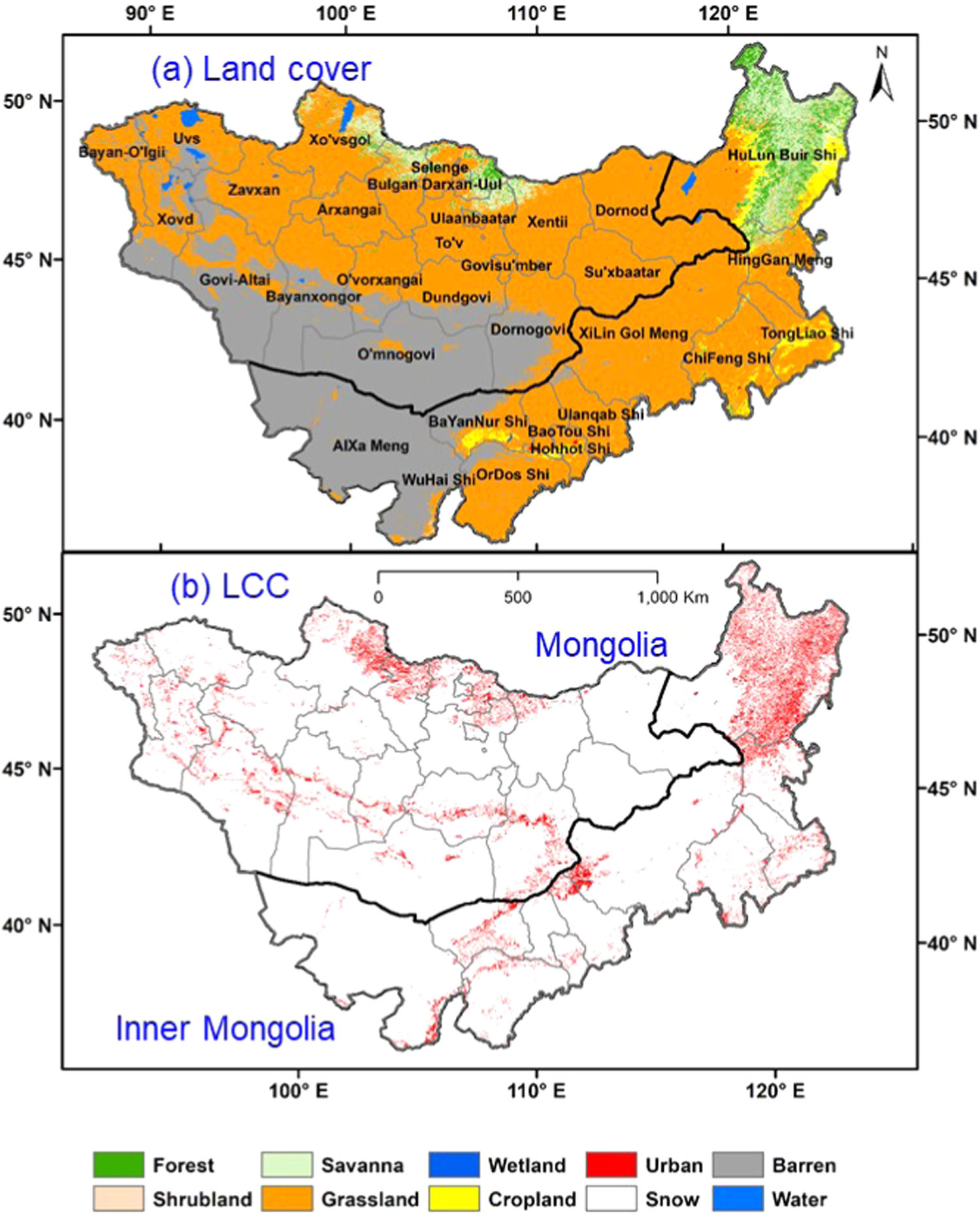
Furthermore, road construction and management should be considered from both social-economic and ecological perspectives, as shown by land degradation arising from improper road management (figure 5). For example, current transportation policies are biased in favor of human systems. Issues arising from urban growth, agricultural development, large-scale afforestation, etc were promoted similarly with relatively small consideration of environmental degradation.
A mediating variable reflecting the socioeconomic and ecosystem changes is land cover/land use that directly affects the SES functions, such as ecosystem productivity, crop yields, timber production, family income, livestock management, urbanization, etc. Institutions in IM and MG have developed a variety of land use policies to address these problems. However, these land use policies have had varying degrees of implementation success. For example, despite the various policies in IM to restore grasslands by reducing livestock population size through numerous policies (Bryan et al 2018), there is no evidence showing a significant improvement in ecosystem GPP or reduction in livestock density (LSKd) (figures 1 and 2).
The proximate causes of these changes appear from multiple forcings such as land conversion, climate change and increasing grazing pressure, but the underlying causes are a legacy of distinct land policies, economic advancements, and cultural resistance to some degree in IM and MG. These different institutional contexts also shape the responses to change in each country. Using livestock as an example, the lack of strong state or customary institutions in MG to coordinate grazing following livestock privatization contributed to a 'tragedy of open access', leading to declining herd mobility, increasing year-round grazing of seasonal pastures, concentrations of herds near settlements and under-use of remote areas, and increased conflicts over pastoral resources (Fernández-Giménez 2001, Fernández-Giménez and Batbuyan 2004, Fernández-Giménez et al 2017). In recent years, there has been an apparent increase in absentee-owned livestock and contract herding (Murphy 2015) which may also contribute to growing herd sizes and poor grazing practices. In contrast, IM suffered from a 'tragedy of privatization': both the livestock and grasslands were privatized through the 'Household Contract Responsibility System', leading to reduced mobility, increased ecosystem fragmentation, and diminished pastoralist culture (Zhang et al 2019).
Although still present in both IM and MG, the social and economic structure of herding has changed drastically in IM, with the majority of herders now settled in towns and reliant on inputs of purchased feed to sustain their animals, which are stabled much of the year. Few IM herders continue to practice extensive livestock husbandry and fewer still move their herds across the landscape with the seasons. In IM, higher income and better job opportunities in cities than in pastoral and agricultural sectors are driving massive rural-to-urban migrations, particularly of the younger generations (Chen et al 2015a). To avoid accelerated degradation and support the community-based management groups, MG should strengthen both formal community-based and government institutions (i.e. policy implementation and enforcement) to coordinate pasture use and enforce seasonal migrations, pasture reserves, limit absentee-owned livestock, and improve education and social support services to remote rural areas to incentivize herders to stay and not migrate to cities. IM should encourage grassland market mechanisms among the herders, enforce the regulation of livestock density, and evaluate the effectiveness of intensive grazing management practices for improving rangeland conditions.
3. Outlooks
Mounting empirical evidence from SES studies clearly indicates that neither biophysical nor socioeconomic systems operate independently; rather, they interact with one another on a global scale, often in a nonlinear fashion, varying across spatial, temporal, and organizational scales and yielding emergent behaviors for each SES (Agrawal and Lemos 2007, Turner et al 2016). Here, we outline our perspectives for the five most critical issues facing the current and future SES on the Mongolian Plateau. It is important to emphasize that these challenges may not apply to every SES at local levels or for different stakeholders on the Mongolian Plateau (Allington et al 2018). For example, the traffic and air pollution concerns for Ulaanbaatar may not apply to other cities in MG. Similarly, issues on large-scale afforestation and development of multi-urban centers are unique to IM.
A particular emphasis of this paper was on the state and divergence of herding practices in IM and MG. The future of nomadic herders in MG is less certain than in IM, mostly because of its landlocked geophysical locations between China and Russia. Popular discourse in the media foretells the end of nomadism, but overlooks Mongolia's long history of shifting livelihood strategies (Honeychurch 2010) and the persistence of mobile pastoralism in marginal environments around the globe, defying predicted extinction (Reid et al 2014). In MG, a more vulnerable pastoral economy and greater access to markets, quality education and health care in the cities have triggered recent rural-to-urban migration (Neupert et al 2012, Save The Children 2013). Although few herders continue to move as frequently or as far as they once did, those who maintain a mobile lifestyle increasingly use technology such as cell phones, social media, satellite dishes, solar panels and motor vehicles to facilitate a 21st century style of nomadism. Mongolian nomadic culture has long been adept at taking up and adapting innovations while maintaining its identity.
SES divergence between IM and MG is apparent and will likely continue. However, lessons learned in IM in combating desertification are certainly applicable in future ecological conservation efforts in MG. For example, water is the limiting environmental factor for the SES on the Plateau. Large-scale afforestation efforts must follow basic ecohydrological principles in terms of species selection and ecological restoration design, and overall planning is needed to maximize effectiveness. Since national land management policies and regulations have long-term effects on grassland ecosystems and regional sustainability, climate change adaptation policies and practices tuned to local conditions should be central to decision-making on natural resource management and socioeconomic development pathways. Apart from the divergences of SES between IM and MG, the lessons learned from this synthesis have the potential for other regional studies. It is well recognized within the scientific community that each SES has unique structure and function, as well as forcing mechanisms (see Turner et al 2016). This suggests that: (1) some challenges in the understanding and projecting of a SES are unique (e.g. afforestation of the Gobi Desert in section 2.3) and should not be over-extrapolated to other regions; (2) some challenges and changes of SES (e.g. urbanization, climatic change, land use change, and declining nomadism) appear as common themes among drylands SES, suggesting possible direct implications of our findings to other regions; and more importantly, (3) future SES research must include institutions—both formal and informal—in the sustainability assessment and modeling of SES.
Acknowledgments
This study was partially supported by the 'Dynamics of Coupled Natural and Human Systems (CNH)' Program of the NSF (#1313761) and the LCLUC program of NASA (NNX14AD85G). We thank the participants of a workshop in Ulaanbaatar during 2–5 June 2017 for the fruitful discussions. P Groisman and G Henebry were supported in part by NASA grant NNX15AP81G. Grant 14.B25.31.0026 of the Ministry of Education and Science of the Russian Federation provided support to P Groisman for his work conducted at the PP Shirshov Institute of Oceanology. P Fan acknowledges the financial support by the LCLUC Program of NASA (NNX15AD51G). L Tian was funded by the National Natural Science Foundation of China (No. 41601100) and the National Key Research and Development Program of China (No. 2017YFB0503005). We appreciate the two anonymous reviewers who provided detailed suggestions for improving the clarity and quality of the manuscript.